2 easy to follow walk route maps of all grades that include part of The Clwydian Way
The Clwydian Way is a 196km (122 miles) circular footpath starting and finishing in Prestatyn in Denbighshire, Wales.
The Clwydian Way is waymarked by named discs and a buzzard motif.
Not familiar with The Clwydian Way?
See these 2 walks that include part of The Clwydian Way on an interactive Google Map
   |
Vital Statistics:
| Length: | 9.5 miles (15 km) |
| Ascent: | 1,359ft (141m) |
| Time: | 4.75hrs |
| Grade: |  |
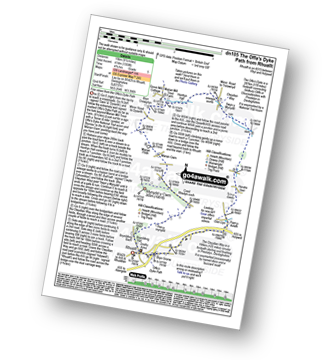
Route Summary:
Rhuallt - The Offa's Dyke Path - Brynllithrig Hall - Pen-y-mynydd - Coed Rhedyn-coch - Mynydd y Cwm (Coed Cwm) - Marian Cwm - Marian Ffrith - Bryn Cnewyllyn - Marian Mill Trout Farm - Henfryn Hall - The Clwydian Way - Swyn y Mynydd - Hendre Fawr - Glan Llyn - Bryn Gronw - Rhuallt
|
Vital Statistics:
| Length: | 7 miles (11 km) |
| Ascent: | 847ft (258m) |
| Time: | 3½ hrs |
| Grade: |  |
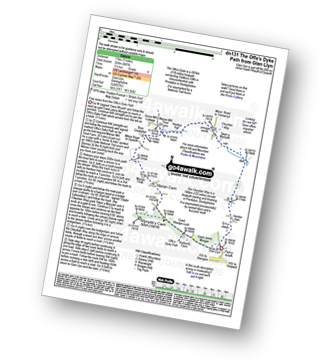
Route Summary:
Glan Llyn - Coed Jenny Morgan - The Offa's Dyke Path - Coed Rhedyn-coch - Mynydd y Cwm (Coed Cwm) - Marian Cwm - Marian Ffrith - Bryn Cnewyllyn - Marian Mill Trout Farm - Henfryn Hall - The Clwydian Way - Swyn y Mynydd - Hendre Fawr - Glan Llyn
Not familiar with The Clwydian Way?
See these 2 walks that include part of The Clwydian Way on an interactive Google Map


