
![]()
Mynydd y Cwm (Coed Cwm)
305m (1001ft)
The Clwydian Hills, Denbighshire, Wales

Not familiar with this top?
You can walk/hike to the top of Mynydd y Cwm (Coed Cwm) by using either of these 2 easy‑to‑follow route maps:
Walk dn131 The Offa's Dyke Path from Glan Llyn
Fine views from the Offa's Dyke Path
   |
|---|
Vital Statistics:
| Length: | 7ml (11km) |
|---|---|
| Ascent: | 847ft (258m) |
| Time: | 3½ hrs |
| Grade: |  (Moderate) (Moderate) |
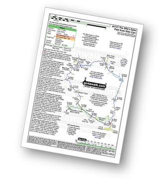
Route Summary:
Glan Llyn - Coed Jenny Morgan - The Offa's Dyke Path - Coed Rhedyn-coch - Mynydd y Cwm (Coed Cwm) - Marian Cwm - Marian Ffrith - Bryn Cnewyllyn - Marian Mill Trout Farm - Henfryn Hall - The Clwydian Way - Swyn y Mynydd - Hendre Fawr - Glan Llyn
Walk dn105 The Offa's Dyke Path from Rhuallt
Fine views from the Offa's Dyke Path
|
|---|
Vital Statistics:
| Length: | 9.5ml (15km) |
|---|---|
| Ascent: | 1,359ft (141m) |
| Time: | 4.75hrs |
| Grade: |  (Moderate) (Moderate) |
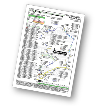
Route Summary:
Rhuallt - The Offa's Dyke Path - Brynllithrig Hall - Pen-y-mynydd - Coed Rhedyn-coch - Mynydd y Cwm (Coed Cwm) - Marian Cwm - Marian Ffrith - Bryn Cnewyllyn - Marian Mill Trout Farm - Henfryn Hall - The Clwydian Way - Swyn y Mynydd - Hendre Fawr - Glan Llyn - Bryn Gronw - Rhuallt
A go4awalk.com downloadable Peak Bagging Map in PDF format featuring Mynydd y Cwm (Coed Cwm) should be available soon.
You can find Mynydd y Cwm (Coed Cwm) & all the walks that climb it on these unique free-to-access Interactive Walk Planning Maps:
1:25,000 scale OS Explorer Maps (orange/yellow covers):
An Interactive Walk Planning Map for OS Explorer 264 Vale of Clwyd / Dyffryn Clwyd is not currently available
An Interactive Walk Planning Map for OS Explorer 265 Clwydian Range / Bryniau is not currently available
1:50,000 scale OS Landranger Map (pink/magenta covers):
 Fellow go4awalkers who have already walked, climbed, scaled, summited, hiked & bagged Mynydd y Cwm (Coed Cwm)
Mark Davidson walked up Mynydd y Cwm (Coed Cwm) on October 17th, 2008 [with] T [weather] Nice & sunny.
Iain Ballard has walked, climbed & bagged Mynydd y Cwm (Coed Cwm).
To add (or remove) your name and experiences on this page - Log On and edit your Personal Mountain Bagging Record
Send us your photographs and pictures on, of, or from Mynydd y Cwm (Coed Cwm)
If you would like to add your walk photographs and pictures to this page, please send them as email attachments (configured for any computer) along with your name to:
and we shall do our best to publish them.
(Guide Resolution = 300dpi. At least = 660pixels (wide) x 440 pixels (high).)

You can also submit photos via our Facebook Page.
NB. Please indicate where each photo was taken and whether you wish us to credit your photos with a Username or your First Name/Last Name.


