13 easy to follow walk route maps of all grades that include part of The Tissington Trail
The Tissington Trail is a 21km (13 miles) linear footpath connecting Ashbourne in Derbyshire, with Parsley Hay in Derbyshire, England.
Originally a railway line built in 1890 to connect Buxton to Ashbourne, it was finally closed to rail traffic in 1967.
The Tissington Trail is waymarked by occasional named posts.
Not familiar with The Tissington Trail?
See these 13 walks that include part of The Tissington Trail on an interactive Google Map
See this list of walks, routes & maps in:
Grade Order | Length Order | Time Order | Walk Number or Start Location Order
NB. To reverse (toggle) this order, click Grade Order again
   |
Vital Statistics:
| Length: | 6.75 miles (11 km) |
| Ascent: | 876ft (267m) |
| Time: | 3½ hrs |
| Grade: |  |
Route Summary:
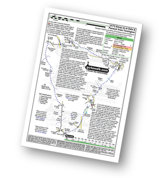
Mappleton Lane (Ashbourne) - The Tissington Trail - Thorpe - The Limestone Way - Coldwall Bridge - River Dove - Big Peg's Wood - Little Peg's Wood - Littlepark Farm - Mappleton (aka Mapleton) - Callow Top - Mappleton Lane (Ashbourne)
|
Vital Statistics:
| Length: | 9.5 miles (15.5 km) |
| Ascent: | 705ft (215m) |
| Time: | 1.25hrs |
| Grade: | |
Route Summary:
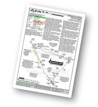
Alsop en le Dale Station - New Hanson Grange - Milldale - River Dove - Mill Dale - Lode Mill Bridge - Coldeaton Bridge - Iron Tors - Gipsy Bank - Drabber Tor - Peasland Rocks - Wolfscote Dale - Biggin Dale - Furny Bottom - Dale End (Heathcote) - Biggin - The Tissington Trail - Alsop en le Dale Station
|
Vital Statistics:
| Length: | 8.5 miles (13.5 km) |
| Ascent: | 1,099ft (335m) |
| Time: | 4.25hrs |
| Grade: |  |

Route Summary:
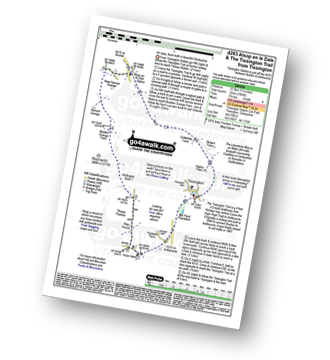
Tissington - The Tissington Trail - Alsop en le Dale Station - Oxdales Farm - Eaton Dale - Eatondale Wood - Flaxdale Holding - Parwich - Bletch Brook - Higher Flats - Tissington
|
Vital Statistics:
| Length: | 12.25 miles (19.5 km) |
| Ascent: | 1,930ft (588m) |
| Time: | 6½ hrs |
| Grade: |  |

Route Summary:
Mappleton Lane (Ashbourne) - The Tissington Trail - Thorpe - Pike House - Bostern Grange Farm - Hanson Grange - The Nabs - Dove Dale - Dove Holes - Taylors Wood - Pickering Rock - Ilam Rock - Shaplow Dale - Lin Dale - Thorpe Cloud - Thorpe Mill Farm - The Limestone Way - Coldwall Bridge - River Dove - Big Peg's Wood - Little Peg's Wood - Littlepark Farm - Mappleton (aka Mapleton) - Callow Top - Mappleton Lane (Ashbourne)
|
Vital Statistics:
| Length: | 9.75 miles (15.5 km) |
| Ascent: | 735ft (224m) |
| Time: | 5.25hrs |
| Grade: | |
Route Summary:
Thorpe - The Tissington Trail - Lin Dale - Dove Dale - The River Dove - Stepping Stones - Lover's Leap - Tissington Spires - Shaplow Dale - Dove Holes - Milldale - Mill Dale - Alsop en le Dale - The Tissington Trail - Tissington - Thorpe
|
Vital Statistics:
| Length: | 15.5 miles (24.5 km) |
| Ascent: | 1,742ft (531m) |
| Time: | 7.25hrs |
| Grade: |  |
Route Summary:
Tissington - The Tissington Trail - Thorpe Station - Thorpe - Pike House - Thorpe Pasture - Bostern Grange Farm - Milldale - River Dove - Mill Dale - Lode Mill Bridge - Coldeaton Bridge - Wolfscote Dale - Biggin Dale - Biggin - The Tissington Trail - Alsop en le Dale Station - Tissington
|
Vital Statistics:
| Length: | 9 miles (14.5 km) |
| Ascent: | 1,453ft (446m) |
| Time: | 4.75hrs |
| Grade: | |
Route Summary:
Tissington - The Tissington Trail - Thorpe Station - Thorpe - Pike House - Thorpe Pasture - Bostern Grange Farm - Alsop en le Dale Station - Parwich - The Limestone Way - Tissington
|
Vital Statistics:
| Length: | 7.25 miles (12.5 km) |
| Ascent: | 1,007ft (307m) |
| Time: | 4 hrs |
| Grade: | |

Route Summary:
Tissington - The Tissington Trail - Thorpe Station - Fenny Bentley - Woodeaves Mill - Woodeaves Farm - Lea Hall - Lee Cottage Farm - Bletch Book - Sittlerlow Farm - Parwich - The Limestone Way - Bletch Brook - The Tissington Trail - Tissington
|
Vital Statistics:
| Length: | 13.5 miles (21.5 km) |
| Ascent: | 1,286ft (392m) |
| Time: | 6.25hrs |
| Grade: | |

Route Summary:
Hartington - Sheen - Brund - Manifold Valley - Longnor - Crowdecote (Crowdicote) - Bridge End Farm - Upper Dove Dale - Pilsbury Castle Hills - Vincent House - Darley Farm - The High Peak Trail - Parlsey Hay - The Tissington Trail - Hartington Station - Heathcote - Heathcote Mere - Highfield Lane - Hartington
|
Vital Statistics:
| Length: | 6.25 miles (10 km) |
| Ascent: | 941ft (287m) |
| Time: | 3.25hrs |
| Grade: | |
Route Summary:
Tissington - Newton Grange - The Tissington Trail - Alsop en le Dale Station - Alsop en le Dale - Flaxdale Holding - Parwich - Bletch Brook - Higher Flats - Tissington
|
Vital Statistics:
| Length: | 7.25 miles (12.5 km) |
| Ascent: | 1,056ft (322m) |
| Time: | 3.75hrs |
| Grade: | |
Route Summary:
Tissington - The Tissington Trail - Thorpe Station - Thorpe - Pike House - Thorpe Pasture - Bostern Grange Farm - Alsop en le Dale Station - Tissington
|
Vital Statistics:
| Length: | 8.75 miles (14 km) |
| Ascent: | 1,171ft (357m) |
| Time: | 4½ hrs |
| Grade: | |

Route Summary:
Hartington - Gorsecroft - Madge Dale - Bank Top Farm - Carder Low - Vincent House - Darley Farm - The High Peak Trail - Parsley Hay - The Tissington Trail - Hartington Station - Heathcote - Heathcote Mere - Highfield Lane - Hartington
|
Vital Statistics:
| Length: | 4 miles (6.5 km) |
| Ascent: | 508ft (155m) |
| Time: | 2 hrs |
| Grade: |  |

Route Summary:
Fenny Bentley - Lees Farm - Darfield Plantation - Tissington - The Tissington Trail - Thorpe Station - Fenny Bentley
See this list of walks, routes & maps in:
Grade Order | Length Order | Time Order | Walk Number or Start Location Order
NB. To reverse (toggle) this order, click Grade Order again
Not familiar with The Tissington Trail?
See these 13 walks that include part of The Tissington Trail on an interactive Google Map


