   |
Vital Statistics:
| Length: | 7mls (11km) |
| Ascent: | 847ft (258m) |
| Time: | 3½hrs |
| Grade: |  |
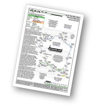
Route outline for walk dn131:
Glan Llyn - Coed Jenny Morgan - The Offa's Dyke Path - Coed Rhedyn-coch - Mynydd y Cwm (Coed Cwm) - Marian Cwm - Marian Ffrith - Bryn Cnewyllyn - Marian Mill Trout Farm - Henfryn Hall - The Clwydian Way - Swyn y Mynydd - Hendre Fawr - Glan Llyn
Peaks, Summits and Tops reached on this walk:
 0 Welsh Mountains |
 0 Wainwrights |
 0 Welsh Nuttalls |
 0 Welsh Deweys |
 0 Wainwright Outlying Fells |
 1 Welsh Marilyn |
 0 Bridgets |
Peak Bagging Statistics for this walk:
The highest point of this walk is Mynydd y Cwm (Coed Cwm) at 305m (1001ft). Mynydd y Cwm (Coed Cwm) is classified as a Welsh Marilyn (142nd highest in Wales, 1371st highest in the UK).
National Trails & Long Paths included on this walk:
Part of this walk follows a section of The Clwydian Way, a 196km (122 miles) circular footpath starting and finishing in Prestatyn in Denbighshire, Wales. The Clwydian Way is waymarked by named discs and a buzzard motif. For more walks that include a section of this trail see The Clwydian Way.
Part of this walk also follows a section of The Offa's Dyke Path, a 287km (178 miles) linear footpath connecting Sedbury Cliffs in Gloucestershire, England with Prestatyn in Denbighshire, Wales. The Offa's Dyke Path is waymarked by a National Trail Acorn. For more walks that include a section of this trail see The Offa's Dyke Path.
You can find this walk and other nearby walks on these unique free-to-access Interactive Walk Planning Maps:
1:25,000 scale OS Explorer Map (orange/yellow covers):
An Interactive Walk Planning Map for OS Explorer 265 Clwydian Range / Bryniau is not currently available
1:50,000 scale OS Landranger Map (pink/magenta covers):
Send us your photographs and pictures from your walks and hikes
We would love to see your photographs and pictures from walk dn131 The Offa's Dyke Path from Glan Llyn. Send them in to us as email attachments (configured for any computer) along with your name and where the picture was taken to:
and we shall do our best to publish them.
(Guide Resolution = 300dpi. At least = 660 pixels (wide) x 440 pixels (high).)

You can also submit photos from walk dn131 The Offa's Dyke Path from Glan Llyn via our Facebook Page.
NB. Please indicate where each photo was taken.


