2 easy to follow walk route maps of all grades that include part of The Lady Anne's Way
The Lady Anne's Way is a 161km (100 miles) linear footpath connecting Skipton in North Yorkshire, with Penrith in Cumbria, England.
The Lady Anne's Way is waymarked by named posts.
Not familiar with The Lady Anne's Way?
See these 2 walks that include part of The Lady Anne's Way on an interactive Google Map
   |
Vital Statistics:
| Length: | 7.75 miles (12.5 km) |
| Ascent: | 1,571ft (479m) |
| Time: | 4½ hrs |
| Grade: |  |
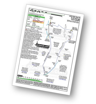
Route Summary:
Outhgill - Thrang Beck - The Lady Anne's Way - Hell Gill Bridge - Hell Gill Beck - Hangingstone Scar - Black Fell Moss - Archy Styrigg (Gregory Chapel) - High Seat (Mallerstang) - Mallerstang Edge - Othgill.
|
Vital Statistics:
| Length: | 9.75 miles (15.5 km) |
| Ascent: | 2,038ft (621m) |
| Time: | 5.75hrs |
| Grade: |  |
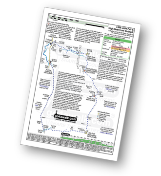
Route Summary:
Thrang Beck - The Lady Anne's Way - Water Cut Sculpture - Hell Gill Bridge - Little Fell (Lunds Fell) (Mallerstang) - Hugh Seat - Black Fell Moss - Archy Styrigg (Gregory Chapel) - High Seat (Mallerstang) - Mallerstang Edge - Outhgill - River Eden - Thrang Beck
Not familiar with The Lady Anne's Way?
See these 2 walks that include part of The Lady Anne's Way on an interactive Google Map


