7 easy to follow walk route maps of all grades that include part of The Pendle Way
The Pendle Way is a 72km (45 miles) circular footpath starting and finishing in Barrowford in Lancashire, England.
The Pendle Way is waymarked by a black witch motif.
Not familiar with The Pendle Way?
See these 7 walks that include part of The Pendle Way on an interactive Google Map
See this list of walks, routes & maps in:
Grade Order | Length Order | Time Order | Walk Number or Start Location Order
NB. To reverse (toggle) this order, click Grade Order again
   |
Vital Statistics:
| Length: | 5.5 miles (9 km) |
| Ascent: | 1,280ft (390m) |
| Time: | 3½ hrs |
| Grade: |  |
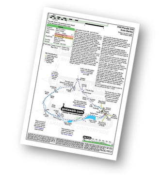
Route Summary:
Barley - Lower Ogden Reservoir - The Pendle Way - Upper Ogden Reservoir - Boar Clough - Ogden Clough - Pendle Moor - Barley Moor - Pendle Hill (Beacon or Big End) - Pendle House - Ing Head Farm - Ing Ends - Barley
|
Vital Statistics:
| Length: | 9 miles (14.5 km) |
| Ascent: | 1,749ft (533m) |
| Time: | 5 hrs |
| Grade: |  |
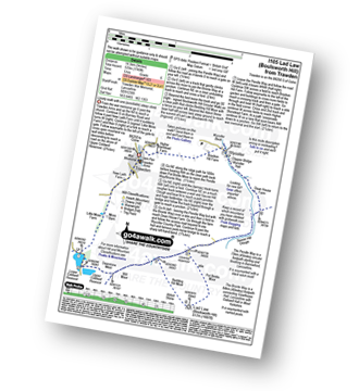
Route Summary:
Trawden - The Pendle Way - Lower Coldwell Reservoir - Upper Coldwell Reservoir - Deerstone Moor - The Bronte Way - Will Moor - Will Moor Clough - Bedding Hill Moor - Abbot Stone (Boulsworth Hill) - Lad Law (Boulsworth Hill) - Saucer Hill Clough - Dean House Farm - Wycoller - Bracken Hill - Trawden
|
Vital Statistics:
| Length: | 4.75 miles (7.5 km) |
| Ascent: | 1,221ft (372m) |
| Time: | 3 hrs |
| Grade: | |

Route Summary:
Barley - Lower Ogden Reservoir - The Pendle Way - Upper Ogden Reservoir - Boar Clough - Pendle Moor - Barley Moor - Pendle Hill (Beacon or Big End) - Pendle House - Ing Head Farm - Ing Ends - Barley,.
|
Vital Statistics:
| Length: | 7.5 miles (12 km) |
| Ascent: | 1,076ft (328m) |
| Time: | 4 hrs |
| Grade: | |
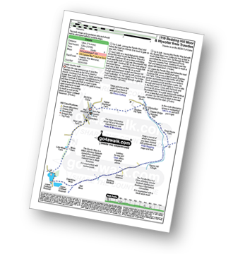
Route Summary:
Trawden - The Pendle Way - Lower Coldwell Reservoir - Upper Coldwell Reservoir - Deerstone Moor - The Bronte Way - Will Moor - Will Moor Clough - Bedding Hill Moor - Saucer Hill Clough - Dean House Farm - Wycoller - Bracken Hill - Trawden
|
Vital Statistics:
| Length: | 8.5 miles (13.5 km) |
| Ascent: | 1,694ft (516m) |
| Time: | 4.75hrs |
| Grade: |  |
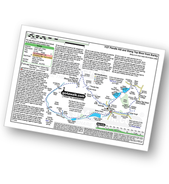
Route Summary:
Barley - Lower Ogden Reservoir - The Pendle Way - Upper Ogden Reservoir - Boar Clough - Ogden Clough - Pendle Moor - Barley Moor - Pendle Hill (Beacon or Big End) - Pendle House - Ing Head Farm - Ing Ends - Barley - Lower Black Moss Reservoir - Upper Black Moss Reservoir - Stang Top Moor - White Hough - Barley
|
Vital Statistics:
| Length: | 10 miles (16 km) |
| Ascent: | 1,267ft (386m) |
| Time: | 5 hrs |
| Grade: | |
Route Summary:
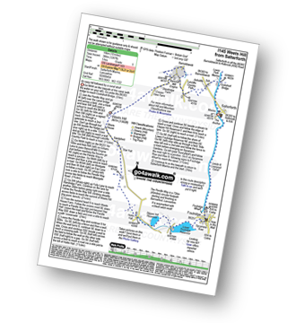
Salterforth Marina - The Leeds and Liverpool Canal - The Leeds and Liverpool Canal Walk - The Pendle Way - Letcliffe Country Park - Bancroft Mill Engine - Barnoldswick - Weets Hill - Weets House - Hollin Hall - Slipper Hill Reservoir - Lower Foulridge Reservoir - Foulridge - Foulridge Wharf - The Leeds and Liverpool Canal - Salterforth.
|
Vital Statistics:
| Length: | 3.75 miles (6 km) |
| Ascent: | 794ft (242m) |
| Time: | 2.25hrs |
| Grade: |  |

Route Summary:
Barley - Barley Green - The Pendle Way - Upper Ogden Reservoir - Fell Wood - Lower Ogden Reservoir - Barley,.
See this list of walks, routes & maps in:
Grade Order | Length Order | Time Order | Walk Number or Start Location Order
NB. To reverse (toggle) this order, click Grade Order again
Not familiar with The Pendle Way?
See these 7 walks that include part of The Pendle Way on an interactive Google Map


