46 walks in The Western Fells area of The Lake District
Forty-six easy-to-follow, hand-crafted walks including routes from Buttermere, Ennerdale Water, Honister, Loweswater, Seathwaite & Seatoller that climb Great Gable (the highest point), Haystacks, High Style, Kirk Fell & Pillar amongst others. More details about each walk can be found below the map.
The Western Fells area of The Lake District National Park
- The edge of The Lake District National Park from Egremont to Cockermouth to the North West
- Lorton Vale, Crummock Water, Buttermere and Honister Pass to the North East
- Sty Head Pass and Wasdale to the South East
- An imaginary line from the Southern Tip of Wast Water to Egremont to the South West
To see interactive maps and list of Mountains, Tops, Peaks and Hills to climb in the area, see Peak Bagging the Lake District Western Fells.
Interactive Map of Walks in The Western Fells area of The Lake District
![]() How to Load this interactive map: Due to usage restrictions, you must be Registered and Logged-On to go4awalk.com to view and use the interactive Google Map below. You do not need to purchase any credits, but you must be Registered and Logged-On.
How to Load this interactive map: Due to usage restrictions, you must be Registered and Logged-On to go4awalk.com to view and use the interactive Google Map below. You do not need to purchase any credits, but you must be Registered and Logged-On.
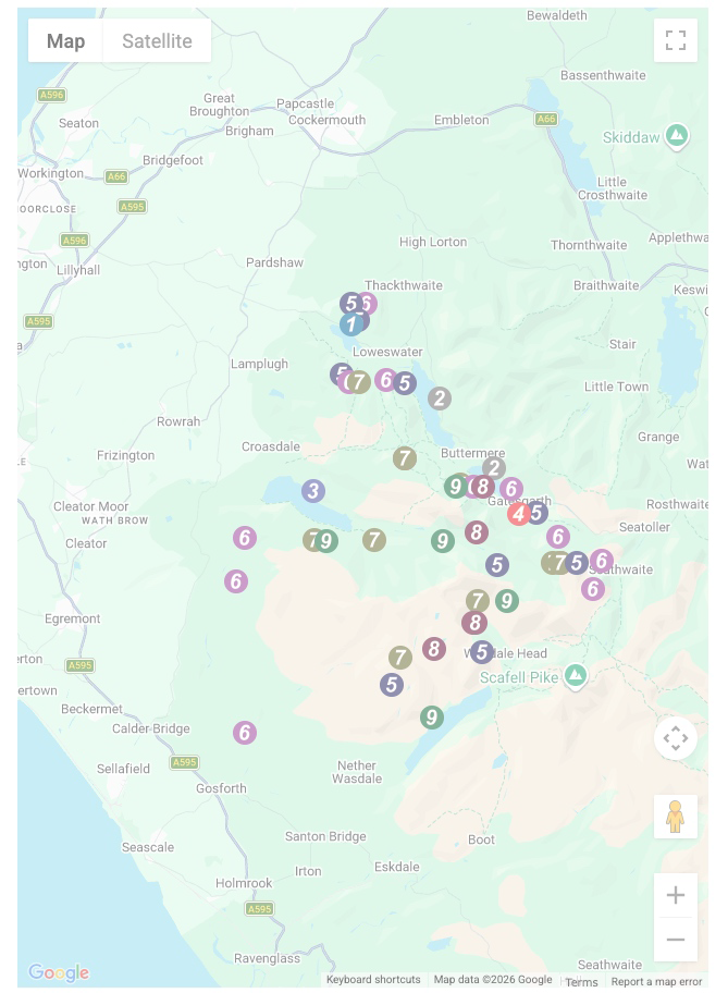
You can use these checkboxes to show only the grades of walk you are interested in:-
Forty-six easy-to-follow, circular, walk route maps in The Western Fells area of The Lake District in Walk Time Order (Shortest to Longest)
See this list of walks, routes & maps in:
Grade Order | Length Order | Time Order | Walk Number or Start Location Order
NB. To reverse (toggle) this order, click Time Order (Shortest to Longest) again
Scroll down the list of walks below & click on each walk title (in blue) to locate it on the map above.
   |
Vital Statistics:
| Length: | 4.25 miles (6.5 km) |
| Ascent: | 98 ft (30 m) |
| Time: | 1½ hrs |
| Grade: |  |
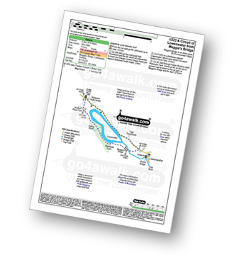
Route Summary:
Maggie's Bridge (Loweswater) - High Thrushbank - Loweswater - Waterend Youth Hostel - Hudson Place Farm - Holme Wood - Watergate Farm - Maggie's Bridge (Loweswater)
|
Vital Statistics:
| Length: | 4.75 miles (7.5 km) |
| Ascent: | 485 ft (148 m) |
| Time: | 2 hrs |
| Grade: |  |
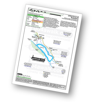
Route Summary:
Buttermere - Dalegarth - Hassnesshow Beck - Gatesgarth - Black Beck - Peggy's Bridge - Burtness Wood - Buttermere
|
Vital Statistics:
| Length: | 7.5 miles (12 km) |
| Ascent: | 262 ft (80 m) |
| Time: | 3 hrs |
| Grade: | |

Route Summary:
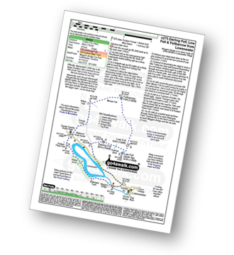
Buttermere - Great Wood - Wood House - Crummock Water - Hause Point - Rannerdale Bridge - Cinderdale Common - Lanthwaite Green - High Wood - Lanthwaite Wood - River Cocker - Park Beck - Iron Stone - Low Ling Crag - Scale Bridge - Buttermere
|
Vital Statistics:
| Length: | 7.25 miles (11.5 km) |
| Ascent: | 683 ft (208 m) |
| Time: | 3.25 hrs |
| Grade: |  |

Route Summary:
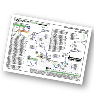
Bowness Knott Car Park - Bowness Plantations - River Liza - Ennerdale Water - Coast To Coast Path - Robin Hood's Chair - Anglers' Crag - Ennerdale Weir - River Ehen - Ennerdale Water - Bowness Knott Car Park
|
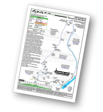
Vital Statistics:
| Length: | 3.25 miles (6 km) |
| Ascent: | 1,920 ft (585 m) |
| Time: | 3½ hrs |
| Grade: |  |

Route Summary:
Buttermere - Gatesgarth - Peggy's Bridge - Buttermere - Scarth Gap - Hay Stacks - Innominate Tarn - Hay Stacks (Haystacks) - Scarth Gap - Peggy's Bridge - Gatesgarth - Buttermere
|
Vital Statistics:
| Length: | 5.25 miles (8.5 km) |
| Ascent: | 2,123 ft (647 m) |
| Time: | 4 hrs |
| Grade: |  |

Route Summary:
Wasdale Head - Mosedale Beck - Dore Head - Yewbarrow (North Top) - Yewbarrow - Bell Rib - Dropping Crag - Over Beck - Overbeck Bridge - Wasdale Head - Wast Water.
|
Vital Statistics:
| Length: | 7 miles (11 km) |
| Ascent: | 1,726 ft (526 m) |
| Time: | 4.25 hrs |
| Grade: | |

Route Summary:
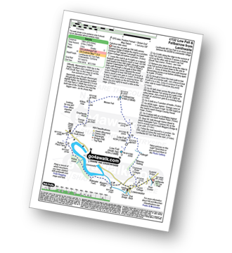
Maggie's Bridge (Loweswater) - Acorn Cottage - Crummockwater Cottages and Foulsyke - Pottergill - Raven Crag (Low Fell) - Low Fell - Low Fell (South Top) - Crabtree Beck - Darling Fell - Loweswater - Waterend Youth Hostel - Hudson Place Farm - Holme Wood - Watergate Farm - Maggie's Bridge (Loweswater)
|
Vital Statistics:
| Length: | 6.5 miles (10.5 km) |
| Ascent: | 1,877 ft (572 m) |
| Time: | 4.25 hrs |
| Grade: | |
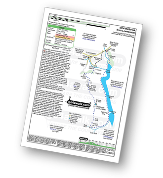
Route Summary:
Lanthwaite - Scale Hill - Scalehill Bridge - Muncaster House - Loweswater - Low Park - Mellbreak (North Top) - Mellbreak - Black Beck (Mosedale) - Scale Knott - Scale Beck - High Ling Crag - Low Ling Crag - Crummock Water - Lanthwaite
|
Vital Statistics:
| Length: | 5.80 miles (8.5 km) |
| Ascent: | 2,455 ft (748 m) |
| Time: | 4½ hrs |
| Grade: | |

Route Summary:
Buttermere - Gatesgarth - Peggy's Bridge - Buttermere - Scarth Gap - Hay Stacks (Haystacks) - Innominate Tarn - Blackbeck Tarn - Black Beck - Green Crag (Buttermere) - Warnscale Beck - Dubs Hut - Dubs Quarry - Fleetwith Pike - Honister Crag (Black Star) - Fleetwith Pike - Fleetwith Edge - Gatesgarth - Buttermere
|
Vital Statistics:
| Length: | 5.25 miles (8.5 km) |
| Ascent: | 2,301 ft (701 m) |
| Time: | 4½ hrs |
| Grade: | |
Route Summary:
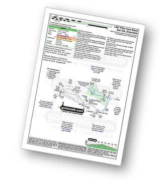
Black Sail Hut (Youth Hostel) - Ennerdale - Black Sail Beck - Black Sail Pass - Looking Stead (Pillar) - Pillar - Black Sail Pass - Black Sail Beck - Black Sail Hut (Youth Hostel) - Ennerdale.
|
Vital Statistics:
| Length: | 5.75 miles (9 km) |
| Ascent: | 2,340 ft (731 m) |
| Time: | 4½ hrs |
| Grade: | |

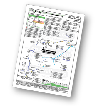
Route Summary:
Honister Pass - Honister Hause - Grey Knotts - Brandreth - Green Gable - Windy Gap - Great Gable - Westmorland Cairn - Beck Head - Beckhead Tarn - Moses' Trod - Wainwright's Coast to Coast Walk - Honister Pass
|
Vital Statistics:
| Length: | 6.5 miles (10.5 km) |
| Ascent: | 2,025 ft (617 m) |
| Time: | 4½ hrs |
| Grade: | |

Route Summary:
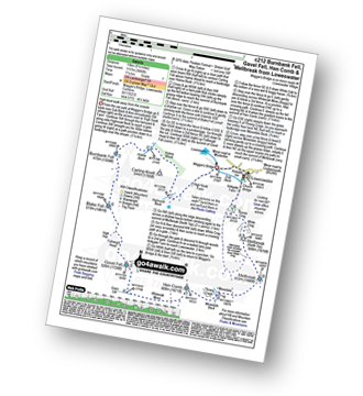
Maggie's Bridge (Loweswater) - Loweswater - High Nook Farm - Highnook Beck - Holme Wood - Burnbank Fell - Sharp Knott - Blake Fell - Fothergill Head - Gavel Fell - Black Crag (Gavel Fell) - Highnook Beck - Maggie's Bridge (Loweswater)
|
Vital Statistics:
| Length: | 7.75 miles (12.5 km) |
| Ascent: | 1,923 ft (586 m) |
| Time: | 4.75 hrs |
| Grade: | |
Route Summary:
Maggie's Bridge (Loweswater) - Loweswater - Darling Fell - Crabtree Beck - Low Fell (South Top) - Low Fell - Fellbarrow - Mosser Fell - Wilkes How - Waterend Youth Hostel - Hudson Place Farm - Holme Wood - Watergate Farm - Maggie's Bridge (Loweswater)
|
Vital Statistics:
| Length: | 6 miles (9.5 km) |
| Ascent: | 2,504 ft (763 m) |
| Time: | 4.75 hrs |
| Grade: | |

Route Summary:
Greendale Farm - Gill Farm - Gill Beck - Buckbarrow - Glade How - Cat Bields - Nether Wasdale Common - Seatallan - Pots of Ashness - Windscale Hows - Middle Fell (Wasdale) - Greendale Gill - Greendale Farm
|
Vital Statistics:
| Length: | 6 miles (9.5 km) |
| Ascent: | 2,845 ft (867 m) |
| Time: | 5 hrs |
| Grade: |  |

Route Summary:
Seathwaite (Borrowdale) - Stockley Bridge - Styhead Tarn - Sty Head - Great Gable - Westmorland Cairn - Windy Gap - Green Gable - Mitchell Cove - Blackmoor Pols - Base Brown - Gillercomb - Sour Milk Gill (Borrowdale) - Seathwaite (Borrowdale)
|
Vital Statistics:
| Length: | 8.75 miles (14 km) |
| Ascent: | 1,884 ft (574 m) |
| Time: | 5 hrs |
| Grade: | |
Route Summary:
Lanthwaite - Acorn Cottage - Crummockwater Cottages and Foulsyke - Pottergill - Raven Crag (Low Fell) - Low Fell - Low Fell (South Top) - Fellbarrow - Mosser Fell - Wilkes How - Waterend Youth Hostel - Hudson Place Farm - Holme Wood - Watergate Farm - Maggie's Bridge (Loweswater) - Loweswater - Lanthwaite
|
Vital Statistics:
| Length: | 8.75 miles (14 km) |
| Ascent: | 1,854 ft (565 m) |
| Time: | 5 hrs |
| Grade: | |

Route Summary:
Friar Well - Friar Gill - River Calder - Tongue How - Town Bank - Lank Rigg - Whoap - Whoap Beck - Stinking Gill - Lankrigg Moss - Latterbrow Moss - Latterbrow Beck - Friar Well
|
Vital Statistics:
| Length: | 6.25 miles (10 km) |
| Ascent: | 6 ft (770 m) |
| Time: | 5 hrs |
| Grade: | |

Route Summary:
Maggie's Bridge (Loweswater) - Loweswater - Kirkgate Farm - Raven Crag - White Crag - Mellbreak (North Top) - Mellbreak - Mosedale Beck (Loweswater) - Thrang Crags - Hen Comb - Little Dodd (Loweswater Fell) - Mosedale Beck (Loweswater) - Kirkgate Farm - Loweswater - Maggie's Bridge (Loweswater)
|
Vital Statistics:
| Length: | 6.25 miles (10 km) |
| Ascent: | 2,756 ft (840 m) |
| Time: | 5.25 hrs |
| Grade: | |

Route Summary:
Honister Pass - Honister Hause - Bell Crags - Hopper Quarry - Honister Quarries - Honister Crag (Black Star) - Burnt Scarth - Fleetwith Pike - Dubs Hut - Dubs Quarry - Warnscale Beck - Green Crag (Buttermere) - Blackbeck Tarn - Innominate Tarn - Hay Stacks (Haystacks) - Innominate Tarn - Loft Beck - Coast to Coast Walk - Brandreth - Grey Knotts - Honister Hause.
|
Vital Statistics:
| Length: | 8.25 miles (13 km) |
| Ascent: | 2,334 ft (711 m) |
| Time: | 5½ hrs |
| Grade: | |

Route Summary:
Buttermere - Gatesgarth - Warnscale Bottom - Warnscale Beck - Green Crag (Buttermere) - Black Beck - Blackbeck Tarn - Innominate Tarn - Hay Stacks (Haystacks) - Scarth Gap - Burtness Wood - Buttermere
|
Vital Statistics:
| Length: | 11 miles (17.5 km) |
| Ascent: | 1,418 ft (432 m) |
| Time: | 5½ hrs |
| Grade: | |
Route Summary:
Gosforth - Rowend Bridge - River Bleng - Bleng Bridge - Hall Bolton - Bolton Head - Low Thistleton Farm - High Thistleton Farm - Guards Head Farm - Hollow Moor - Brown Edge - Blengdale Forest - River Bleng - Scalderskew Beck - Ponsonby Fell - Scargreen Farm - Gidd Hall Farm - Ponsonby Old Hall - Middle Boonwood - Gosforth
|
Vital Statistics:
| Length: | 7.75 miles (12.5 km) |
| Ascent: | 2,028 ft (618 m) |
| Time: | 5½ hrs |
| Grade: | |
Route Summary:
Scaly Moss - Blackely Moss - Heckbarley Wood - Red Moss - Grike - Crag Fell - Black Pots - Whoap - Lank Rigg - Whoap Beck - Lankrigg Moss - Stinking Gill - Blackeley Raise - Whorl Gill - Scaly Moss
|
Vital Statistics:
| Length: | 8.25 miles (13 km) |
| Ascent: | 3,016 ft (919 m) |
| Time: | 6 hrs |
| Grade: | |
Route Summary:
Seatoller - Seathwaite (Borrowdale) - Sourmilk Gill (Borrowdale) - Gillercomb - Blackmoor Pols - Mitchell Cove - Green Gable - Windy Gap - Great Gable - Westmorland Cairn - Beck Head - Beckhead Tarn - Moses' Trod - Honister Pass - Honister Hause - Wainwright's Coast to Coast Walk - Seatoller
|
Vital Statistics:
| Length: | 7.5 miles (12 km) |
| Ascent: | 3,289 ft (1,002 m) |
| Time: | 6 hrs |
| Grade: | |
Route Summary:
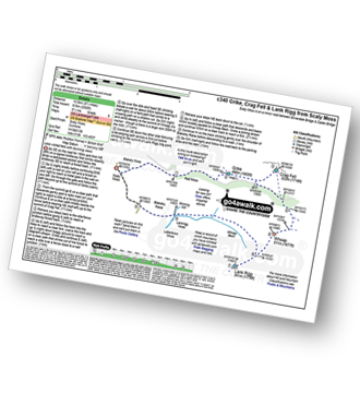
Honister Pass - Honister Hause - Grey Knotts - Brandreth - Green Gable - Windy Gap - Great Gable - Westmorland Cairn - Beck Head - Beckhead Tarn - Kirk Fell (East Top) - Kirk Fell - Moses' Trod - Wainwright's Coast to Coast Walk - Honister Pass
|
Vital Statistics:
| Length: | 8.5 miles (13.5 km) |
| Ascent: | 2,540 ft (774 m) |
| Time: | 6 hrs |
| Grade: | |

Route Summary:
Maggie's Bridge (Loweswater) - Loweswater - High Nook Farm - Highnook Beck - Holme Wood - Holme Beck - Burnbank Fell - Sharp Knott - Blake Fell - Fothergill Head - Gavel Fell - Grain Gill - Whiteoak Moss - Hen Comb - Little Dodd (Loweswater Fell) - Mosedale (Loweswater) - Mosedale Beck (Loweswater) - Loweswater Village - Maggie's Bridge (Loweswater)
|
Vital Statistics:
| Length: | 7.5 miles (12 km) |
| Ascent: | 3,338 ft (1,017 m) |
| Time: | 6.25 hrs |
| Grade: | |

Route Summary:
Buttermere - Sourmilk Gill - Bleaberry Tarn - Dodd (Buttermere) - The Saddle - Red Pike (Buttermere) - High Stile - High Crag (Buttermere) - Gamlin End - Seat (Buttermere) - Scarth Gap - Peggy's Bridge - Burtness Wood - Buttermere
|
Vital Statistics:
| Length: | 8.75 miles (14 km) |
| Ascent: | 3,390 ft (1,033 m) |
| Time: | 6.25 hrs |
| Grade: |  |

Route Summary:
Buttermere - Scale Force - Scale Beck - Blea Crag - Lingcomb Edge - Red Pike (Buttermere) - High Stile - High Crag (Buttermere) - Gamlin End - Seat (Buttermere) - Scarth Gap - Burtness Wood - Sourmilk Gill - Buttermere
|
Vital Statistics:
| Length: | 9.75 miles (15.5 km) |
| Ascent: | 2,734 ft (833 m) |
| Time: | 6.25 hrs |
| Grade: | |

Route Summary:
Buttermere - Buttermere Dubbs - Scale Bridge - Scale Force - Scale Beck - Blea Crag - Lingcomb Edge - Ling Comb - Little Dodd (Ennerdale) - Starling Dodd - Great Borne - Floutern Tarn - Black Beck (Mosedale) - Scale Force - Scale Beck (Crummock Water) - Crummock Water - Buttermere
|
Vital Statistics:
| Length: | 9.75 miles (15.5 km) |
| Ascent: | 3,157 ft (962 m) |
| Time: | 6½ hrs |
| Grade: | |

Route Summary:
Buttermere - Sourmilk Gill - Bleaberry Tarn - Dodd (Buttermere) - The Saddle - Red Pike (Buttermere) - Ling Comb - Little Dodd (Ennerdale) - Starling Dodd - Great Borne - Floutern Tarn - Black Beck (Mosedale) - Blea Crag - Scale Force - Scale Beck (Crummock Water) - Crummock Water - Buttermere Dubs - Buttermere
|
Vital Statistics:
| Length: | 9.75 miles (15.5 km) |
| Ascent: | 3,236 ft (986 m) |
| Time: | 6.75 hrs |
| Grade: | |
Route Summary:
Greendale Farm - Gill Farm - Buckbarrow - Seatallan - Pots of Ashness - Gowder Crag - Haycock - Little Lad Crag - Nether Beck - Wast Water - Wasdale - Greendale Farm
|
Vital Statistics:
| Length: | 8.5 miles (13.5 km) |
| Ascent: | 4,260 ft (1,298 m) |
| Time: | 7.25 hrs |
| Grade: | |

Route Summary:
Honister Pass - Honister Hause - Green Crag (Buttermere) - Black Beck - Blackbeck Tarn - Innominate Tarn - Hay Stacks (Haystacks) - Scarth Gap - Ennerdale - River Liza - Black Sail Hut (Youth Hostel) - Black Sail Path - Kirk Fell - Kirk Fell (East Top) - Beckhead Tarn - Beck Head - Great Gable - Westmorland Cairn - Windy Gap - Green Gable - Gillercomb Head - Brandreth - Grey Knotts - Honister Hause.
|
Vital Statistics:
| Length: | 9.5 miles (15 km) |
| Ascent: | 3,666 ft (1,117 m) |
| Time: | 7.25 hrs |
| Grade: | |
Route Summary:
Maggie's Bridge (Loweswater) - Loweswater - High Nook Farm - Highnook Beck - Holme Wood - Holme Beck - Burnbank Fell - Sharp Knott - Blake Fell - Fothergill Head - Gavel Fell - Grain Gill - Whiteoak Moss - Hen Comb - Thrang Crags - Mosedale (Loweswater) - Mosedale Beck (Loweswater) - Mellbreak - Mellbreak (North Top) - White Crag - Loweswater Village - Maggie's Bridge (Loweswater)
|
Vital Statistics:
| Length: | 11.25 miles (18 km) |
| Ascent: | 3,275 ft (998 m) |
| Time: | 7½ hrs |
| Grade: | |

Route Summary:
Bowness Knott Car Park Ennerdale Water - Char Dub - Silver Cove Beck - Woundell Beck - Caw Fell - Little Gowder Crag - Haycock - Great Scoat Fell - Scoat Fell (Little Scoat Fell) - Steeple - Long Crag - Moss Dub - Lingmell Plantation - Bowness Knott Car Park Ennerdale Water.
|
Vital Statistics:
| Length: | 9 miles (14.5 km) |
| Ascent: | 3,965 ft (1,208 m) |
| Time: | 7½ hrs |
| Grade: | |

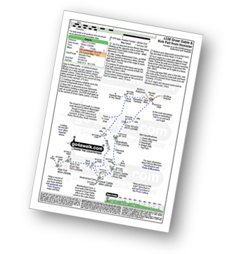
Route Summary:
Honister Pass - Honister Hause - Grey Knotts - Brandreth - Blackmoor Pols - Base Brown - Mitchell Cove - Green Gable - Windy Gap - Great Gable - Westmorland Cairn - Beck Head - Beckhead Tarn - Kirk Fell (East Top) - Kirk Fell - Moses' Trod - Wainwright's Coast to Coast Walk - Honister Pass
|
Vital Statistics:
| Length: | 11.75 miles (19 km) |
| Ascent: | 2,970 ft (905 m) |
| Time: | 7½ hrs |
| Grade: | |
Route Summary:
Ennerdale Weir - Ennerdale Water - Silver Cove Beck - Woundell Beck - Caw Fell - Silver Cove - Iron Crag - Crag Fell - Grike - Ennerdale Weir
|
Vital Statistics:
| Length: | 7.75 miles (12.5 km) |
| Ascent: | 4,808 ft (1,465 m) |
| Time: | 7.75 hrs |
| Grade: | |

Route Summary:
Wasdale Head - Kirk Fell - Kirk Fell (East Top) - Black Sail Pass - Looking Stead (Pillar) - High Level Route - Robinson's Cairn - Pillar - Wind Gap - Black Crag (Pillar) - Scoat Fell (Little Scoat Fell) - Steeple - Red Pike (Wasdale) - Dore Head - Mosedale Beck - Wasdale Head - Wast Water.
|
Vital Statistics:
| Length: | 11 miles (17 km) |
| Ascent: | 4,001 ft (1,219 m) |
| Time: | 8 hrs |
| Grade: |  |

Route Summary:
Wasdale Head - Mosedale Beck - Black Sail Pass - High Level Route - Robinson's Cairn - Pillar - Wind Gap - Black Crag (Pillar) - Scoat Fell (Little Scoat Fell) - Red Pike (Wasdale) - Dore Head - Over Beck - Wasdale Head - Wast Water.
|
Vital Statistics:
| Length: | 11.25 miles (18 km) |
| Ascent: | 4,132 ft (1,259 m) |
| Time: | 8.25 hrs |
| Grade: | |

Route Summary:
Buttermere - Scale Force - Scale Beck - Blea Crag - Lingcomb Edge - Red Pike (Buttermere) - High Stile - High Crag (Buttermere) - Gamlin End - Seat (Buttermere) - Scarth Gap - Hay Stacks (Haystacks) - Innominate Tarn - Blackbeck Tarn - Black Beck - Green Crag (Buttermere) - Warnscale Beck - Warnscale Bottom - Gatesgarth - Buttermere
|
Vital Statistics:
| Length: | 10.25 miles (16.5 km) |
| Ascent: | 4,611 ft (1,405 m) |
| Time: | 8½ hrs |
| Grade: | |

Route Summary:
Buttermere - Gatesgarth - Peggy's Bridge - Scarth Gap Pass - Scarth Gap - Black Sail Hut (Youth Hostel) - Black Sail Pass - Looking Stead (Pillar) - High Level Route - Robinson's Cairn - Pillar - Wind Gap - Black Crag (Pillar) - High Beck - Ennerdale - Scarth Gap Pass - Peggy's Bridge - Gatescarth - Buttermere
|
Vital Statistics:
| Length: | 11 miles (17.5 km) |
| Ascent: | 4,782 ft (1,457 m) |
| Time: | 8.75 hrs |
| Grade: | |

Route Summary:
Wasdale Head - Mosedale Beck - Black Sail Pass - Looking Stead (Pillar) - High Level Route - Robinson's Cairn - Pillar - Wind Gap - Black Crag (Pillar) - Scoat Fell (Little Scoat Fell) - Steeple - Red Pike (Wasdale) - Dore Head - Yewbarrow (North Top) - Yewbarrow - Dropping Crag - Bell Rib - Over Beck - Wasdale Head - Wast Water.
|
Vital Statistics:
| Length: | 11.25 miles (18 km) |
| Ascent: | 5,100 ft (1,554 m) |
| Time: | 9.25 hrs |
| Grade: | |

Route Summary:
Greendale Farm - Middle Fell (Wasdale) - Seatallan - Pots of Ashness - Gowder Crag - Haycock - Great Scoat Fell - Steeple - Scoat Fell (Little Scoat Fell) - Red Pike (Wasdale) - Dore Head - Yewbarrow (North Top) - Yewbarrow - Bell Rib - Dropping Crag - Overbeck Bridge - Wast Water - Greendale Farm
|
Vital Statistics:
| Length: | 15.25 miles (24.5 km) |
| Ascent: | 4,125 ft (1,257 m) |
| Time: | 9.75 hrs |
| Grade: |  |

Route Summary:
Ennerdale Weir - Ennerdale Water - Silver Cove Beck - Woundell Beck - Little Gowder Crag - Haycock - Caw Fell - Silver Cove - Iron Crag - Whoap - Lank Rigg - Crag Fell - Grike - Ennerdale Weir
|
Vital Statistics:
| Length: | 11.25 miles (18 km) |
| Ascent: | 5,819 ft (1,773 m) |
| Time: | 10 hrs |
| Grade: | |

Route Summary:
Wasdale Head - Moses' Trod - Lingmell Beck - Gable Beck Bridge - Sty Head - Great Gable - Westmorland Cairn - Beck Head - Beckhead Tarn - Kirk Fell (East Top) - Kirk Fell - Black Sail Pass - Looking Stead (Pillar) - High Level Route - Robinson's Cairn - Pillar - Wind Gap - Black Crag (Pillar) - Scoat Fell (Little Scoat Fell) - Steeple - Red Pike (Wasdale) - Dore Head - Mosedale Beck - Wasdale Head - Wast Water.
|
Vital Statistics:
| Length: | 15.25 miles (24.5 km) |
| Ascent: | 4,841 ft (1,475 m) |
| Time: | 10½ hrs |
| Grade: | |

Route Summary:
Wasdale Head - (National Trust Campsite) - Wast Water - Lingmell Gill - Illgill Head - Whin Rigg - Greathall Gill - Low Wood - Lund Bridge - Woodhow Farm - Woodhow Tarn - Scale Farm - Tosh Tarn - Gill Farm - Gill Beck - Buckbarrow - Cold Well - Nether Wasdale Common - Seatallan - Windscale Hows - Middle Fell (Wasdale) - Greendale Farm - Nether Beck - Overbeck Bridge - Wasdale Head - Wast Water.
|
Vital Statistics:
| Length: | 16 miles (25.5 km) |
| Ascent: | 6,285 ft (1,915 m) |
| Time: | 12.25 hrs |
| Grade: | |
Route Summary:
Buttermere - Scale Force - Scale Beck - Blea Crag - Great Borne - Starling Dodd - Little Dodd (Ennerdale) - Ling Comb - Lingcomb Edge - Red Pike (Buttermere) - Dodd (Buttermere) - Red Pike (Buttermere) - High Stile - High Crag (Buttermere) - Gamlin End - Seat (Buttermere) - Scarth Gap - Hay Stacks (Haystacks) - Innominate Tarn - Blackbeck Tarn - Black Beck - Green Crag (Buttermere) - Warnscale Beck - Dubs Hut - Dubs Quarry - Fleetwith Pike - Honister Crag (Black Star) - Fleetwith Pike - Fleetwith Edge - Gatesgarth - Buttermere
|
Vital Statistics:
| Length: | 18.75 miles (30 km) |
| Ascent: | 7,309 ft (2,408 m) |
| Time: | 14.75 hrs |
| Grade: | |

Route Summary:
Bowness Knott Car Park Ennerdale - Low Gillerthwaite Field Centre - High Gillerthwaite Yourth Hostel - Red Pike (Buttermere) - High Stile - High Crag (Buttermere) - Seat (Buttermere) - Scarth Gap - Hay Stacks (Haystacks) - Innominate Tarn - Blackbeck Tarn - Black Beck - Green Crag (Buttermere) - Great Round How - Brandreth - Gillercomb Head - Green Gable - Windy Gap - Great Gable - Westmorland Cairn - Beck Head - Beckhead Tarn - Kirk Fell (East Top) - Kirk Fell - Black Sail Pass - Looking Stead (Pillar) - High Level Route - Robinson's Cairn - Pillar - Wind Gap - Black Crag (Pillar) - High Beck - Low Beck - Ennerdale.
See this list of walks, routes & maps in:
Grade Order | Length Order | Time Order | Walk Number or Start Location Order
NB. To reverse (toggle) this order, click Time Order (Shortest to Longest) again


