Buttermere Walk: The Complete Guide to the Lake District's Most Beautiful Circular Route
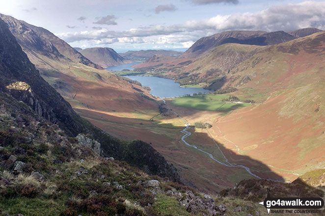 Buttermere Lake from Haystacks - Wainwright's favourite view
Buttermere is a small village nestled between Buttermere Lake and Crummock Water. There are approximately 92 residents of Buttermere (as of 2021).
This Buttermere circular walk is one of the most iconic and rewarding low-level walks in the Lake District - offering dramatic mountain scenery, peaceful lakeshore paths, and a family-friendly trail that suits almost everyone.
Quick Facts
| Distance: | 4.75 miles (7.5 km) |
|---|---|
| Difficulty: | Easy — mostly flat lakeside paths |
| Time Required: | 2–3 hours |
| Total Ascent: | 485ft (148m) |
| Grade: | 2 (Easy) |
| Start/Finish: | Buttermere Village |
| Best Direction: | Clockwise for the best uninterrupted views |
| Terrain: | Lakeside tracks, woodland paths, short rock section, small tunnel |
Why This is One of the Best Walks in the Lake District
What makes the Buttermere walk special is the sheer drama of the surrounding fells. Peaks like Fleetwith Pike, Haystacks, High Stile and High Snockrigg rise sharply from the water, creating perfect reflections on calm days. Yet the route itself remains wonderfully accessible, making it suitable for first-time visitors, families and seasoned walkers alike.
The walk packs in a surprising amount of variety: open lakeshore, woodland, waterfalls, farmland, a rock tunnel, and constantly changing viewpoints. And because it stays close to the water, it delivers maximum scenery with minimal effort.
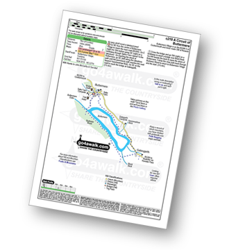
Walk c219 A Circular Walk around Buttermere Lake — Step-by-Step Guide
Park at the National Trust Car Park (Long How) or the village parking area near the Buttermere Court Hotel (formerly the Fish Inn).
-
Go NE out of the centre of Buttermere Village to reach the main road (B5289). Go E (right) for 50m before going SE (right) on a bridleway through Sykes Farm signed ' to the lakeshore'. On reaching the shore of Buttermere, go SE (left) along the lakeshore path, passing through a rock tunnel before the permissive path reaches a road beyond Hassnesshow Beck. (2½km)
-
Go SE (right) on the narrow road to reach the bridge at Gatesgarth. (1km)
-
Cross the bridge and then go SW (right) on a bridleway past Gatesgarth Farm (campsite) & the southern end of the lake to reach a bridge over Black Beck. (½km)
-
Go NW (right) beside the beck (on your right) to rejoin the shore of Buttermere. Follow the clear path back through Burtness Wood to reach the northern end of the lake. (2½km)
-
Go N (right) over a footbridge to return to Buttermere Village and the start. (1 km)
-
Grab a coffee, ice cream or pub lunch as a perfect end to the walk.
Buttermere Walk Map
   |
Vital Statistics:
| Length: | 4.75 miles (7.5 km) | |
| Ascent: | 485 ft (148 m) | |
| Time: | 2 hrs | |
| Grade: |  | (Easy) |
Route Summary:
Buttermere - Dalegarth - Hassnesshow Beck - Gatesgarth - Black Beck - Peggy's Bridge - Burtness Wood - Buttermere
Parking & Facilities
- Long How (National Trust) Car Park — get there early, quickly fills up in summer
- Buttermere Village Parking — smaller but closer to the start
- Public toilets available in Buttermere village
- Pubs, cafés and ice-cream shops available seasonally
- Campsite
Seasonal Path Closure
Between 1 April and 30 June, a small section of the north-western lakeshore path is closed to protect nesting sandpipers. Alternative signposted routes keep the circular walk fully accessible.
Local Tips to Get the Best Out of Your Walk
- Walk anti-clockwise - all the best views stay in front of you.
- Arrive early on sunny weekends - parking fills quickly.
- Take waterproof shoes - some areas can be muddy after rain.
- Go early or late for the quietest experience.
- Dogs welcome but must be on leads near livestock.
FAQs
Is the Buttermere walk suitable for kids?
Yes — it's one of the best family-friendly lake walks in the National Park.
Is the route accessible?
Most of the path is flat and well-maintained, though the rock tunnel area is uneven.
Can the walk be done in poor weather?
Generally, yes, but visibility is reduced, and paths can become muddy. Avoid after severe rain.
Other Walks from Buttermere Village:
Easier Walks | Moderate Walks | Harder Walks
Easier Walks
|
Vital Statistics:
| Length: | 7.5 miles (12 km) | |
| Ascent: | 262 ft (80 m) | |
| Time: | 3 hrs | |
| Grade: | | (Easy) |

Route Summary:
Buttermere - Great Wood - Wood House - Crummock Water - Hause Point - Rannerdale Bridge - Cinderdale Common - Lanthwaite Green - High Wood - Lanthwaite Wood - River Cocker - Park Beck - Iron Stone - Low Ling Crag - Scale Bridge - Buttermere
|
Vital Statistics:
| Length: | 3.25 miles (5 km) | |
| Ascent: | 968 ft (295 m) | |
| Time: | 2.25hrs | |
| Grade: |  | (Easy) |
Moderate Walks
|
Vital Statistics:
| Length: | 3.25 miles (6 km) | |
| Ascent: | 1,920 ft (585 m) | |
| Time: | 3½ hrs | |
| Grade: |  | (Moderate) |

Route Summary:
Buttermere - Gatesgarth - Peggy's Bridge - Buttermere - Scarth Gap - Hay Stacks - Innominate Tarn - Hay Stacks (Haystacks) - Scarth Gap - Peggy's Bridge - Gatesgarth - Buttermere
|
Vital Statistics:
| Length: | 5.80 miles (8.5 km) | |
| Ascent: | 2,455 ft (748 m) | |
| Time: | 4½ hrs | |
| Grade: |  | (Moderate) |

Route Summary:
Buttermere - Gatesgarth - Peggy's Bridge - Buttermere - Scarth Gap - Hay Stacks (Haystacks) - Innominate Tarn - Blackbeck Tarn - Black Beck - Green Crag (Buttermere) - Warnscale Beck - Dubs Hut - Dubs Quarry - Fleetwith Pike - Honister Crag (Black Star) - Fleetwith Pike - Fleetwith Edge - Gatesgarth - Buttermere
|
Vital Statistics:
| Length: | 4.75 miles (7.5 km) | |
| Ascent: | 2,363 ft (720 m) | |
| Time: | 4.25hrs | |
| Grade: | | (Moderate) |

Route Summary:
Buttermere - Dalegarth - Hassnesshow Beck - Goat Crag - Goat Gills - Robinson - Buttermere Moss - High Snockrigg - Buttermere
|
Vital Statistics:
| Length: | 7.5 miles (12 km) | |
| Ascent: | 3,338 ft (1,017 m) | |
| Time: | 6.25hrs | |
| Grade: |  | (Moderate) |

Route Summary:
Buttermere - Sourmilk Gill - Bleaberry Tarn - Dodd (Buttermere) - The Saddle - Red Pike (Buttermere) - High Stile - High Crag (Buttermere) - Gamlin End - Seat (Buttermere) - Scarth Gap - Peggy's Bridge - Burtness Wood - Buttermere
|
Vital Statistics:
| Length: | 8.25 miles (13 km) | |
| Ascent: | 2,334 ft (711 m) | |
| Time: | 5½ hrs | |
| Grade: | | (Moderate) |

Route Summary:
Buttermere - Gatesgarth - Warnscale Bottom - Warnscale Beck - Green Crag (Buttermere) - Black Beck - Blackbeck Tarn - Innominate Tarn - Hay Stacks (Haystacks) - Scarth Gap - Burtness Wood - Buttermere
|
Vital Statistics:
| Length: | 9.75 miles (15.5 km) | |
| Ascent: | 2,734 ft (833 m) | |
| Time: | 6.25hrs | |
| Grade: | | (Moderate) |

Route Summary:
Buttermere - Buttermere Dubbs - Scale Bridge - Scale Force - Scale Beck - Blea Crag - Lingcomb Edge - Ling Comb - Little Dodd (Ennerdale) - Starling Dodd - Great Borne - Floutern Tarn - Black Beck (Mosedale) - Scale Force - Scale Beck (Crummock Water) - Crummock Water - Buttermere
Harder Walks
|
Vital Statistics:
| Length: | 8.75 miles (14 km) | |
| Ascent: | 3,390 ft (1,033 m) | |
| Time: | 6.25hrs | |
| Grade: |  | (Hard) |

Route Summary:
Buttermere - Scale Force - Scale Beck - Blea Crag - Lingcomb Edge - Red Pike (Buttermere) - High Stile - High Crag (Buttermere) - Gamlin End - Seat (Buttermere) - Scarth Gap - Burtness Wood - Sourmilk Gill - Buttermere
|
Vital Statistics:
| Length: | 9.75 miles (15.5 km) | |
| Ascent: | 3,157 ft (962 m) | |
| Time: | 6½ hrs | |
| Grade: | | (Hard) |

Route Summary:
Buttermere - Sourmilk Gill - Bleaberry Tarn - Dodd (Buttermere) - The Saddle - Red Pike (Buttermere) - Ling Comb - Little Dodd (Ennerdale) - Starling Dodd - Great Borne - Floutern Tarn - Black Beck (Mosedale) - Blea Crag - Scale Force - Scale Beck (Crummock Water) - Crummock Water - Buttermere Dubs - Buttermere
|
Vital Statistics:
| Length: | 10.25 miles (16.5 km) | |
| Ascent: | 4,611 ft (1,405 m) | |
| Time: | 8½ hrs | |
| Grade: |  | (Hard) |

Route Summary:
Buttermere - Gatesgarth - Peggy's Bridge - Scarth Gap Pass - Scarth Gap - Black Sail Hut (Youth Hostel) - Black Sail Pass - Looking Stead (Pillar) - High Level Route - Robinson's Cairn - Pillar - Wind Gap - Black Crag (Pillar) - High Beck - Ennerdale - Scarth Gap Pass - Peggy's Bridge - Gatescarth - Buttermere
|
Vital Statistics:
| Length: | 11.25 miles (18 km) | |
| Ascent: | 4,132 ft (1,259 m) | |
| Time: | 8.25hrs | |
| Grade: | | (Hard) |

Route Summary:
Buttermere - Scale Force - Scale Beck - Blea Crag - Lingcomb Edge - Red Pike (Buttermere) - High Stile - High Crag (Buttermere) - Gamlin End - Seat (Buttermere) - Scarth Gap - Hay Stacks (Haystacks) - Innominate Tarn - Blackbeck Tarn - Black Beck - Green Crag (Buttermere) - Warnscale Beck - Warnscale Bottom - Gatesgarth - Buttermere
|
Vital Statistics:
| Length: | 16 miles (25.5 km) | |
| Ascent: | 6,285 ft (1,915 m) | |
| Time: | 12.25hrs | |
| Grade: |  | (Very Hard) |
Route Summary:
Buttermere - Scale Force - Scale Beck - Blea Crag - Great Borne - Starling Dodd - Little Dodd (Ennerdale) - Ling Comb - Lingcomb Edge - Red Pike (Buttermere) - Dodd (Buttermere) - Red Pike (Buttermere) - High Stile - High Crag (Buttermere) - Gamlin End - Seat (Buttermere) - Scarth Gap - Hay Stacks (Haystacks) - Innominate Tarn - Blackbeck Tarn - Black Beck - Green Crag (Buttermere) - Warnscale Beck - Dubs Hut - Dubs Quarry - Fleetwith Pike - Honister Crag (Black Star) - Fleetwith Pike - Fleetwith Edge - Gatesgarth - Buttermere


