Interactive Peak Bagging Map: The Lake District National Park
The Lake District National Park is located in North West England, wholly within the county of Cumbria.
If you count only the Wainwright Outlying Fells there are 116 tops to climb, bag & conquer and the highest point is Walna Scar at 621m (2,038ft).
To see Mountains, Peaks, Tops and Hills displayed in different ways - see the options in the left-hand column and towards the bottom of this page.
![]() Your Personal Bagging Record for The Lake District National Park
Your Personal Bagging Record for The Lake District National Park
Log On and Reload this page to show which Mountains, Peaks, Tops and Hills you have already climbed, bagged & conquered [. . . more details]
Interactive Map of Mountains, Peaks, Tops and Hills in The Lake District National Park
![]() How to Load this interactive map: Due to usage restrictions, you must be Registered and Logged-On to go4awalk.com to view and use the interactive Google Map below. You do not need to purchase any credits, but you must be Registered and Logged-On. NB If you want to record which Mountains, Peaks, Tops and Hills you have sucessfully climber and bagged, you will will need one credit to activate your Personal Mountain Bagging Record (PMBR).
How to Load this interactive map: Due to usage restrictions, you must be Registered and Logged-On to go4awalk.com to view and use the interactive Google Map below. You do not need to purchase any credits, but you must be Registered and Logged-On. NB If you want to record which Mountains, Peaks, Tops and Hills you have sucessfully climber and bagged, you will will need one credit to activate your Personal Mountain Bagging Record (PMBR).
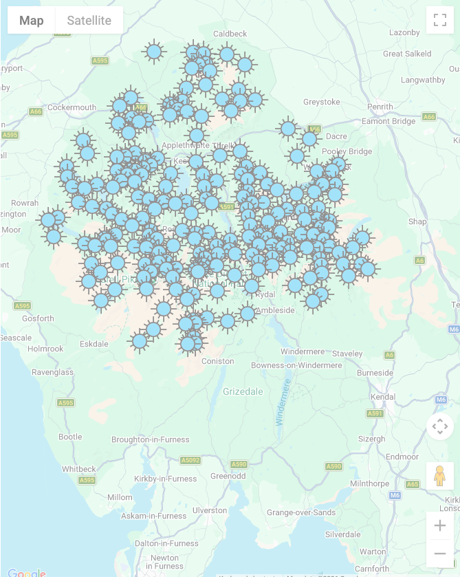
Scroll down this list of mountains, peaks, tops & hills below and tap/click on each name (in blue) to locate it's position on the map above.
See this list in: Alphabetical Order | Height Order‡
To reverse the order select the link again.
Mountain, Peak, Top or Hill:
Bagged

![]()
1. Walna Scar
621m (2,038ft)
Wainwright Outlying Fell
See more details, photos, trip reports and easy-to-follow walks up Walna Scar
![]()
2. Black Combe
600m (1,969ft)
Wainwright Outlying Fell
See more details, photos, trip reports and easy-to-follow walks up Black Combe
![]()
3. Great Yarlside
585m (1,920ft)
Wainwright Outlying Fell
See more details, photos, trip reports and easy-to-follow walks up Great Yarlside
![]()
4. Howes (Mosedale)
580m (1,904ft)
Wainwright Outlying Fell
See more details, photos, trip reports and easy-to-follow walks up Howes (Mosedale)
![]()
5. Whitfell (Whit Fell)
573m (1,880ft)
Wainwright Outlying Fell
See more details, photos, trip reports and easy-to-follow walks up Whitfell (Whit Fell)
![]()
6. Wasdale Pike
565m (1,854ft)
Wainwright Outlying Fell
See more details, photos, trip reports and easy-to-follow walks up Wasdale Pike
![]()
7. Great Saddle Crag
565m (1,854ft)
Wainwright Outlying Fell
See more details, photos, trip reports and easy-to-follow walks up Great Saddle Crag
![]()
8. Ancrow Brow (Swinklebank Crag)
555m (1,822ft)
Wainwright Outlying Fell
See more details, photos, trip reports and easy-to-follow walks up Ancrow Brow (Swinklebank Crag)
![]()
9. Buck Barrow
545m (1,788ft)
Wainwright Outlying Fell
See more details, photos, trip reports and easy-to-follow walks up Buck Barrow
![]()
10. Burn Moor
543m (1,782ft)
Wainwright Outlying Fell
See more details, photos, trip reports and easy-to-follow walks up Burn Moor
![]()
11. Ancrow Brow (North East Top)
541m (1,775ft)
Wainwright Outlying Fell
See more details, photos, trip reports and easy-to-follow walks up Ancrow Brow (North East Top)
![]()
12. Kinmont Buck Barrow
535m (1,755ft)
Wainwright Outlying Fell
See more details, photos, trip reports and easy-to-follow walks up Kinmont Buck Barrow
![]()
13. High Wether Howe
531m (1,743ft)
Wainwright Outlying Fell
See more details, photos, trip reports and easy-to-follow walks up High Wether Howe
![]()
14. White Howe (Bannisdale)
530m (1,739ft)
Wainwright Outlying Fell
See more details, photos, trip reports and easy-to-follow walks up White Howe (Bannisdale)
![]()
15. Caw (Dunnerdale Fells)
529m (1,736ft)
Wainwright Outlying Fell
See more details, photos, trip reports and easy-to-follow walks up Caw (Dunnerdale Fells)
![]()
16. The Forest (Bannisdale)
528m (1,732ft)
Wainwright Outlying Fell
See more details, photos, trip reports and easy-to-follow walks up The Forest (Bannisdale)
![]()
17. Lord's Seat (Crookdale)
524m (1,720ft)
Wainwright Outlying Fell
See more details, photos, trip reports and easy-to-follow walks up Lord's Seat (Crookdale)
![]()
18. Little Yarlside
516m (1,694ft)
Wainwright Outlying Fell
See more details, photos, trip reports and easy-to-follow walks up Little Yarlside
![]()
19. Seat Robert
515m (1,690ft)
Wainwright Outlying Fell
See more details, photos, trip reports and easy-to-follow walks up Seat Robert
![]()
20. Capplebarrow
512m (1,680ft)
Wainwright Outlying Fell
See more details, photos, trip reports and easy-to-follow walks up Capplebarrow
![]()
21. Fewling Stones
510m (1,674ft)
Wainwright Outlying Fell
See more details, photos, trip reports and easy-to-follow walks up Fewling Stones
![]()
22. Sleddale Pike
505m (1,657ft)
Wainwright Outlying Fell
See more details, photos, trip reports and easy-to-follow walks up Sleddale Pike
![]()
23. Hare Shaw
503m (1,650ft)
Wainwright Outlying Fell
See more details, photos, trip reports and easy-to-follow walks up Hare Shaw
![]()
24. Ulthwaite Rigg
500m (1,641ft)
Wainwright Outlying Fell
See more details, photos, trip reports and easy-to-follow walks up Ulthwaite Rigg
![]()
25. Stainton Pike
498m (1,634ft)
Wainwright Outlying Fell
See more details, photos, trip reports and easy-to-follow walks up Stainton Pike
![]()
26. High House Bank
495m (1,625ft)
Wainwright Outlying Fell
See more details, photos, trip reports and easy-to-follow walks up High House Bank
![]()
27. Yoadcastle
494m (1,621ft)
Wainwright Outlying Fell
See more details, photos, trip reports and easy-to-follow walks up Yoadcastle
![]()
28. Robin Hood (Crookdale)
493m (1,618ft)
Wainwright Outlying Fell
See more details, photos, trip reports and easy-to-follow walks up Robin Hood (Crookdale)
![]()
29. Long Crag (Bannisdale Fell)
493m (1,618ft)
Wainwright Outlying Fell
See more details, photos, trip reports and easy-to-follow walks up Long Crag (Bannisdale Fell)
![]()
30. Nabs Moor
492m (1,615ft)
Wainwright Outlying Fell
See more details, photos, trip reports and easy-to-follow walks up Nabs Moor
![]()
31. Woodend Height (Yoadcastle)
490m (1,608ft)
Wainwright Outlying Fell
See more details, photos, trip reports and easy-to-follow walks up Woodend Height (Yoadcastle)
![]()
32. Whatshaw Common
485m (1,592ft)
Wainwright Outlying Fell
See more details, photos, trip reports and easy-to-follow walks up Whatshaw Common
![]()
33. Hesk Fell (Ulpha Fell)
477m (1,565ft)
Wainwright Outlying Fell
See more details, photos, trip reports and easy-to-follow walks up Hesk Fell (Ulpha Fell)
![]()
34. Stoupdale Head
472m (1,549ft)
Wainwright Outlying Fell
See more details, photos, trip reports and easy-to-follow walks up Stoupdale Head
![]()
35. Pikes (Caw)
469m (1,539ft)
Wainwright Outlying Fell
See more details, photos, trip reports and easy-to-follow walks up Pikes (Caw)
![]()
36. White Pike (Birkby Fell)
442m (1,451ft)
Wainwright Outlying Fell
See more details, photos, trip reports and easy-to-follow walks up White Pike (Birkby Fell)
![]()
37. Great Ladstones
439m (1,441ft)
Wainwright Outlying Fell
See more details, photos, trip reports and easy-to-follow walks up Great Ladstones
![]()
38. Kit Crag (Naddle Forest)
435m (1,428ft)
Wainwright Outlying Fell
See more details, photos, trip reports and easy-to-follow walks up Kit Crag (Naddle Forest)
![]()
39. Wallow Crag (Naddle Forest)
428m (1,404ft)
Wainwright Outlying Fell
See more details, photos, trip reports and easy-to-follow walks up Wallow Crag (Naddle Forest)
![]()
40. Great Worm Crag
427m (1,401ft)
Wainwright Outlying Fell
See more details, photos, trip reports and easy-to-follow walks up Great Worm Crag
![]()
41. Brunt Knott (Potter Fell)
427m (1,401ft)
Wainwright Outlying Fell
See more details, photos, trip reports and easy-to-follow walks up Brunt Knott (Potter Fell)
![]()
42. Hollow Moor (Green Quarter)
426m (1,398ft)
Wainwright Outlying Fell
See more details, photos, trip reports and easy-to-follow walks up Hollow Moor (Green Quarter)
![]()
43. Harper Hills
420m (1,378ft)
Wainwright Outlying Fell
See more details, photos, trip reports and easy-to-follow walks up Harper Hills
![]()
44. Green Pikes (Caw)
420m (1,378ft)
Wainwright Outlying Fell
See more details, photos, trip reports and easy-to-follow walks up Green Pikes (Caw)
![]()
45. White Combe
415m (1,362ft)
Wainwright Outlying Fell
See more details, photos, trip reports and easy-to-follow walks up White Combe
![]()
46. Hugh's Laithes Pike
415m (1,362ft)
Wainwright Outlying Fell
See more details, photos, trip reports and easy-to-follow walks up Hugh's Laithes Pike
![]()
47. Hollow Moor (North East Top)
409m (1,342ft)
Wainwright Outlying Fell
See more details, photos, trip reports and easy-to-follow walks up Hollow Moor (North East Top)
![]()
48. Todd Fell
401m (1,316ft)
Wainwright Outlying Fell
See more details, photos, trip reports and easy-to-follow walks up Todd Fell
![]()
49. Langhowe Pike
400m (1,313ft)
Wainwright Outlying Fell
See more details, photos, trip reports and easy-to-follow walks up Langhowe Pike
![]()
50. Whiteside Pike
397m (1,303ft)
Wainwright Outlying Fell
See more details, photos, trip reports and easy-to-follow walks up Whiteside Pike
![]()
51. Hugh's Laithes Pike (North East Top)
395m (1,296ft)
Wainwright Outlying Fell
![]()
52. Brunt Knott (South Top)
395m (1,296ft)
Wainwright Outlying Fell
See more details, photos, trip reports and easy-to-follow walks up Brunt Knott (South Top)
![]()
53. Brunt Knott (East Top)
390m (1,279ft)
Wainwright Outlying Fell
See more details, photos, trip reports and easy-to-follow walks up Brunt Knott (East Top)
![]()
54. Heughscar Hill
375m (1,231ft)
Wainwright Outlying Fell
See more details, photos, trip reports and easy-to-follow walks up Heughscar Hill
![]()
55. Stickle Pike (Dunnerdale Fells)
375m (1,230ft)
Wainwright Outlying Fell
See more details, photos, trip reports and easy-to-follow walks up Stickle Pike (Dunnerdale Fells)
![]()
56. The Pike (Hesk Fell)
370m (1,214ft)
Wainwright Outlying Fell
See more details, photos, trip reports and easy-to-follow walks up The Pike (Hesk Fell)
![]()
57. Lamb Pasture
367m (1,204ft)
Wainwright Outlying Fell
See more details, photos, trip reports and easy-to-follow walks up Lamb Pasture
![]()
58. Raven's Crag (Stickle Pike)
361m (1,185ft)
Wainwright Outlying Fell
See more details, photos, trip reports and easy-to-follow walks up Raven's Crag (Stickle Pike)
![]()
59. Dent (Long Barrow)
352m (1,155ft)
Wainwright Outlying Fell
See more details, photos, trip reports and easy-to-follow walks up Dent (Long Barrow)
![]()
60. Faulds Brow
344m (1,129ft)
Wainwright Outlying Fell
See more details, photos, trip reports and easy-to-follow walks up Faulds Brow
![]()
61. Knipescar Common
342m (1,122ft)
Wainwright Outlying Fell
See more details, photos, trip reports and easy-to-follow walks up Knipescar Common
![]()
62. Scalebarrow Knott
338m (1,109ft)
Wainwright Outlying Fell
See more details, photos, trip reports and easy-to-follow walks up Scalebarrow Knott
![]()
63. Boat How
337m (1,106ft)
Wainwright Outlying Fell
See more details, photos, trip reports and easy-to-follow walks up Boat How
![]()
64. Top o' Selside
335m (1,099ft)
Wainwright Outlying Fell
See more details, photos, trip reports and easy-to-follow walks up Top o' Selside
![]()
65. Ulgraves (Potter Fell)
333m (1,093ft)
Wainwright Outlying Fell
See more details, photos, trip reports and easy-to-follow walks up Ulgraves (Potter Fell)
![]()
66. The Knott (Stainton Fell)
331m (1,086ft)
Wainwright Outlying Fell
See more details, photos, trip reports and easy-to-follow walks up The Knott (Stainton Fell)
![]()
67. Gummer's How
321m (1,054ft)
Wainwright Outlying Fell
See more details, photos, trip reports and easy-to-follow walks up Gummer's How
![]()
68. Rough Crag (Birker Fell)
319m (1,047ft)
Wainwright Outlying Fell
See more details, photos, trip reports and easy-to-follow walks up Rough Crag (Birker Fell)
![]()
69. Carron Crag
314m (1,031ft)
Wainwright Outlying Fell
See more details, photos, trip reports and easy-to-follow walks up Carron Crag
![]()
70. Seat How (Birker Fell)
311m (1,021ft)
Wainwright Outlying Fell
See more details, photos, trip reports and easy-to-follow walks up Seat How (Birker Fell)
![]()
71. Tarn Hill (Dunnerdale Fells)
311m (1,020ft)
Wainwright Outlying Fell
See more details, photos, trip reports and easy-to-follow walks up Tarn Hill (Dunnerdale Fells)
![]()
72. Ponsonby Fell
311m (1,020ft)
Wainwright Outlying Fell
See more details, photos, trip reports and easy-to-follow walks up Ponsonby Fell
![]()
73. Water Crag (Birker Fell)
305m (1,001ft)
Wainwright Outlying Fell
See more details, photos, trip reports and easy-to-follow walks up Water Crag (Birker Fell)
![]()
74. Great Stickle (Dunnerdale Fells)
305m (1,001ft)
Wainwright Outlying Fell
See more details, photos, trip reports and easy-to-follow walks up Great Stickle (Dunnerdale Fells)
![]()
75. Burney (Great Burney)
298m (978ft)
Wainwright Outlying Fell
See more details, photos, trip reports and easy-to-follow walks up Burney (Great Burney)
![]()
76. Cold Fell (Cleator Moor)
293m (961ft)
Wainwright Outlying Fell
See more details, photos, trip reports and easy-to-follow walks up Cold Fell (Cleator Moor)
![]()
77. Caermote Hill
285m (935ft)
Wainwright Outlying Fell
See more details, photos, trip reports and easy-to-follow walks up Caermote Hill
![]()
78. St. John's Hill (Caermote Hill)
285m (935ft)
Wainwright Outlying Fell
See more details, photos, trip reports and easy-to-follow walks up St. John's Hill (Caermote Hill)
![]()
79. The Knott (Dunnerdale Fells)
284m (932ft)
Wainwright Outlying Fell
See more details, photos, trip reports and easy-to-follow walks up The Knott (Dunnerdale Fells)
![]()
80. Dunnerdale Fell (Broughton Mills)
280m (919ft)
Wainwright Outlying Fell
See more details, photos, trip reports and easy-to-follow walks up Dunnerdale Fell (Broughton Mills)
![]()
81. High Knott (Williamson's Monument)
275m (902ft)
Wainwright Outlying Fell
![]()
82. Flat Fell
272m (892ft)
Wainwright Outlying Fell
See more details, photos, trip reports and easy-to-follow walks up Flat Fell
![]()
83. Claife Heights (High Blind How)
270m (886ft)
Wainwright Outlying Fell
See more details, photos, trip reports and easy-to-follow walks up Claife Heights (High Blind How)
![]()
84. Staveley Fell
265m (870ft)
Wainwright Outlying Fell
See more details, photos, trip reports and easy-to-follow walks up Staveley Fell
![]()
85. High Light Haw (Top o' Selside)
259m (850ft)
Wainwright Outlying Fell
See more details, photos, trip reports and easy-to-follow walks up High Light Haw (Top o' Selside)
![]()
86. Hugill Fell
256m (840ft)
Wainwright Outlying Fell
See more details, photos, trip reports and easy-to-follow walks up Hugill Fell
![]()
87. Reston Scar
255m (837ft)
Wainwright Outlying Fell
See more details, photos, trip reports and easy-to-follow walks up Reston Scar
![]()
88. Beacon (Blawith Fells)
255m (836ft)
Wainwright Outlying Fell
See more details, photos, trip reports and easy-to-follow walks up Beacon (Blawith Fells)
![]()
89. Setmurthy Common (Watch Hill)
254m (833ft)
Wainwright Outlying Fell
See more details, photos, trip reports and easy-to-follow walks up Setmurthy Common (Watch Hill)
![]()
90. Grandsire
251m (824ft)
Wainwright Outlying Fell
See more details, photos, trip reports and easy-to-follow walks up Grandsire
![]()
91. Grandsire (South West Top)
247m (810ft)
Wainwright Outlying Fell
See more details, photos, trip reports and easy-to-follow walks up Grandsire (South West Top)
![]()
92. Blawith Knott
246m (807ft)
Wainwright Outlying Fell
See more details, photos, trip reports and easy-to-follow walks up Blawith Knott
![]()
93. Low Light Haw (Top o' Selside)
245m (804ft)
Wainwright Outlying Fell
See more details, photos, trip reports and easy-to-follow walks up Low Light Haw (Top o' Selside)
![]()
94. Clints Crags
245m (804ft)
Wainwright Outlying Fell
See more details, photos, trip reports and easy-to-follow walks up Clints Crags
![]()
95. Latterbarrow
244m (801ft)
Wainwright Outlying Fell
See more details, photos, trip reports and easy-to-follow walks up Latterbarrow
![]()
96. Dunmallard Hill (Dunmallet)
240m (788ft)
Wainwright Outlying Fell
See more details, photos, trip reports and easy-to-follow walks up Dunmallard Hill (Dunmallet)
![]()
97. Orrest Head
238m (781ft)
Wainwright Outlying Fell
See more details, photos, trip reports and easy-to-follow walks up Orrest Head
![]()
98. Watch Hill (Cockermouth)
235m (771ft)
Wainwright Outlying Fell
See more details, photos, trip reports and easy-to-follow walks up Watch Hill (Cockermouth)
![]()
99. Saskills (Newton Fell)
235m (771ft)
Wainwright Outlying Fell
See more details, photos, trip reports and easy-to-follow walks up Saskills (Newton Fell)
![]()
100. Scout Scar (Barrowfield)
233m (765ft)
Wainwright Outlying Fell
See more details, photos, trip reports and easy-to-follow walks up Scout Scar (Barrowfield)
![]()
101. School Knott
232m (761ft)
Wainwright Outlying Fell
See more details, photos, trip reports and easy-to-follow walks up School Knott
![]()
102. Muncaster Fell (Hooker Crag)
231m (758ft)
Wainwright Outlying Fell
See more details, photos, trip reports and easy-to-follow walks up Muncaster Fell (Hooker Crag)
![]()
103. Tottlebank Height
229m (752ft)
Wainwright Outlying Fell
See more details, photos, trip reports and easy-to-follow walks up Tottlebank Height
![]()
104. Brock Barrow (Top o' Selside)
229m (752ft)
Wainwright Outlying Fell
See more details, photos, trip reports and easy-to-follow walks up Brock Barrow (Top o' Selside)
![]()
105. Irton Pike
225m (738ft)
Wainwright Outlying Fell
See more details, photos, trip reports and easy-to-follow walks up Irton Pike
![]()
106. Hampsfell
221m (725ft)
Wainwright Outlying Fell
See more details, photos, trip reports and easy-to-follow walks up Hampsfell
![]()
107. Lord's Seat (Whitbarrow Scar)
215m (706ft)
Wainwright Outlying Fell
See more details, photos, trip reports and easy-to-follow walks up Lord's Seat (Whitbarrow Scar)
![]()
108. Wool Knott
213m (699ft)
Wainwright Outlying Fell
See more details, photos, trip reports and easy-to-follow walks up Wool Knott
![]()
109. Yew Bank (Blawith Fells)
207m (679ft)
Wainwright Outlying Fell
See more details, photos, trip reports and easy-to-follow walks up Yew Bank (Blawith Fells)
![]()
110. Cunswick Scar
207m (679ft)
Wainwright Outlying Fell
See more details, photos, trip reports and easy-to-follow walks up Cunswick Scar
![]()
111. Brant Fell
191m (626ft)
Wainwright Outlying Fell
See more details, photos, trip reports and easy-to-follow walks up Brant Fell
![]()
112. Bigland Barrow
183m (601ft)
Wainwright Outlying Fell
See more details, photos, trip reports and easy-to-follow walks up Bigland Barrow
![]()
113. Dixon Heights (Newton Fell)
177m (581ft)
Wainwright Outlying Fell
See more details, photos, trip reports and easy-to-follow walks up Dixon Heights (Newton Fell)
![]()
114. Finsthwaite Heights
170m (558ft)
Wainwright Outlying Fell
See more details, photos, trip reports and easy-to-follow walks up Finsthwaite Heights
![]()
115. Cartmel Fell (Raven's Barrow)
152m (499ft)
Wainwright Outlying Fell
See more details, photos, trip reports and easy-to-follow walks up Cartmel Fell (Raven's Barrow)
![]()
116. Humphrey Head
53m (173ft)
Wainwright Outlying Fell
See more details, photos, trip reports and easy-to-follow walks up Humphrey Head
See this list in: Alphabetical Order | Height Order‡
To reverse the order select the link again.
View 116 Mountains, Peaks, Tops and Hills:
- On an Interactive Google Map with a list of tops below it. (1)
- On a Detailed List in:
Alphabetical Order | Height Order - On one page with 'yet-to-be-bagged' listed 1st
& then 'already-bagged' tops listed 2nd in:
Alphabetical Order | Height Order - On one page with 'already-bagged' tops listed 1st
& then 'yet-to-be-bagged' tops listed 2nd in:
Alphabetical Order | Height Order - If you are not familiar with this National Park, here is an Interactive Map showing the different areas of The Lake District
- Make sure you look at our Unique Interactive Walk Planning Map of The Lake District National Park
 The view from Scafell Pike
Photo: David Cochrane
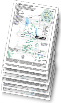
Downloadable PDF Peak Bagging Maps:
On Seven Downloadable PDFs you can print or save to your phone covering:
- The Central Fells #
- The Eastern Fells #
- The Far Eastern Fells #
- The Northern Fells #
- The North Western Fells #
- The Southern Fells #
- The Western Fells #
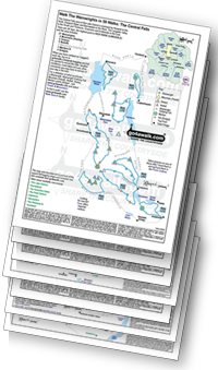
On Seven Special Wainwright Baggers' versions of the above Downloadable PDFs you can print or save to your phone detailing the routes that Bag All 214 Wainwrights in just 59 walks:
- The Wainwrights in the Central Fells Area #
- The Wainwrights in the The Eastern Fells Area #
- The Wainwrights in the The Far Eastern Fells Area #
- The Wainwrights in the The Northern Fells Area #
- The Wainwrights in the The North Western Fells Area #
- The Wainwrights in the The Southern Fells Area #
- The Wainwrights in the The Western Fells Area #
# These Peak Baggers' Maps will prove incredibly useful if you need to know what's classified as what when you are up in the mountains and cannot get a phone signal.
Is there a Mountain, Peak, Top or Hill missing from the above google map or list?
Let us know an we will add it to our database.

To contribute to go4awalk.com or to contact us about anything at all - see Talk To Us.
For help see Help.
go4awalk.com and go4awalk.co.uk are registered trademarks of TMDH Limited.
Copyright © 2000-2026 TMDH Limited. All rights reserved.
Copyright Terms & Conditions Privacy Statement
A - Z Walks Home Log On/Accounts Photo Gallery Walk Ideas and Collections Fell Facts Hill Skills Walking Questions and Answers Your Stories News Competitions Product Reviews/Gear Tests Walking Gear Guides Peaks and Mountains Peak Bagging Find New Walking Friends Camping GPS Waypoints for Walking Contents Walk Search Talk To Us go4awalk.com Help Free Example Walks Newsletter


