Walk The 136 Mountains in Wales

The summit of Snowdon, The Highest Mountain in Wales
Photo: Don Williams
A Mountain in Wales is defined as being any high point over 610m (2000ft) above mean sea-level with at least 30m (approx 100ft) of 'prominence' or 'ascent' on all sides.
Welsh mountains are also sometimes known by the acronym Hewitt which stands for Hill in England, Wales or Ireland over Two Thousand feet.
There are currently 525 Mountains (or Hewitts)
- 180 in England, 136 in Wales and 209 in Ireland.
Mountains in Scotland using the same criteria (i.e. over 610m (2,000ft) & 30m of 'prominence') are commonly known as Murdos, Corbett Tops and Graham Tops.
LOG ON and RELOAD this page to show how many Mountains in each region you have already climbed, bagged & conquered.
The Mountains in Wales
(136/0) - 0%
136 tops including: Snowdon (Yr Wyddfa), Cadair Idris, Pen y Fan . . .
-
View on a Google Map Only

-
View on a Google Map with a list of tops below

- View as a detailed list: In Alphabetical Order | In Height Order
- View as one page with 'yet-to-be-bagged' listed 1st & then 'already bagged' tops listed 2nd: In Alphabetical Order | In Height Order
- View as one page with 'already bagged' tops listed 1st & then 'yet-to-be-bagged' tops listed 2nd:
In Alphabetical Order |
In Height Order
The Mountains in Wales by Welsh Region or Area

The Mountains in The Brecon Beacons
(23/0) - 0%
23 tops including: Pen y Fan, Waun Fach, Fan Brycheiniog . . .
-
View on a Google Map Only

-
View on a Google Map with a list of tops below

- View as a detailed list: In Alphabetical Order | In Height Order
- View as one page with 'yet-to-be-bagged' listed 1st & then 'already bagged' tops listed 2nd: In Alphabetical Order | In Height Order
- View as one page with 'already bagged' tops listed 1st & then 'yet-to-be-bagged' tops listed 2nd:
In Alphabetical Order |
In Height Order
Interactive Map of the areas of The Brecon Beacons
(with the number of Mountains in each area)
-
View on a Google Map Only

-
View on a Google Map with a list of tops below

- View as a detailed list: In Alphabetical Order | In Height Order
- View as one page with 'yet-to-be-bagged' listed 1st & then 'already bagged' tops listed 2nd: In Alphabetical Order | In Height Order
- View as one page with 'already bagged' tops listed 1st & then 'yet-to-be-bagged' tops listed 2nd:
In Alphabetical Order |
In Height Order
The Mountains in The Brecon Beacons Area of Bannau Brycheiniog (The Brecon Beacons National Park)
(14/0) - 0%
14 tops including: Pen y Fan, Fan Brycheiniog, Cribyn . . .
-
View on a Google Map Only

-
View on a Google Map with a list of tops below

- View as a detailed list: In Alphabetical Order | In Height Order
- View as one page with 'yet-to-be-bagged' listed 1st & then 'already bagged' tops listed 2nd: In Alphabetical Order | In Height Order
- View as one page with 'already bagged' tops listed 1st & then 'yet-to-be-bagged' tops listed 2nd:
In Alphabetical Order |
In Height Order
The Mountains in The Black Mountains Area of Bannau Brycheiniog (The Brecon Beacons National Park)
(9/0) - 0%
9 tops including: Waun Fach, Pen y Gadair Fawr . . .

The Mountains in The Cambrian Mountains
(10/0) - 0%
10 tops including: Pen Pumlumon Fawr, Drygarn Fawr, Great Rhos . . .
-
View on a Google Map Only

-
View on a Google Map with a list of tops below

- View as a detailed list: In Alphabetical Order | In Height Order
- View as one page with 'yet-to-be-bagged' listed 1st & then 'already bagged' tops listed 2nd: In Alphabetical Order | In Height Order
- View as one page with 'already bagged' tops listed 1st & then 'yet-to-be-bagged' tops listed 2nd:
In Alphabetical Order |
In Height Order
Interactive Map of the areas of The Cambrian Mountains
(with the number of Mountains in each area)
-
View on a Google Map Only

-
View on a Google Map with a list of tops below

- View as a detailed list: In Alphabetical Order | In Height Order
- View as one page with 'yet-to-be-bagged' listed 1st & then 'already bagged' tops listed 2nd: In Alphabetical Order | In Height Order
- View as one page with 'already bagged' tops listed 1st & then 'yet-to-be-bagged' tops listed 2nd:
In Alphabetical Order |
In Height Order
The Mountains in The Central area of Mynyddoedd Cambria (The Cambrian Mountains)
(4/0) - 0%
4 tops including: Pen Pumlumon Fawr, Y Garn . . .
-
View on a Google Map Only

-
View on a Google Map with a list of tops below

- View as a detailed list: In Alphabetical Order | In Height Order
- View as one page with 'yet-to-be-bagged' listed 1st & then 'already bagged' tops listed 2nd: In Alphabetical Order | In Height Order
- View as one page with 'already bagged' tops listed 1st & then 'yet-to-be-bagged' tops listed 2nd:
In Alphabetical Order |
In Height Order
The Mountains in The South Western Area of Mynyddoedd Cambria (The Cambrian Mountains)
(3/0) - 0%
3 tops: Drygarn Fawr, Gorllwyn, Pen y Garn
-
View on a Google Map Only

-
View on a Google Map with a list of tops below

- View as a detailed list: In Alphabetical Order | In Height Order
- View as one page with 'yet-to-be-bagged' listed 1st & then 'already bagged' tops listed 2nd: In Alphabetical Order | In Height Order
- View as one page with 'already bagged' tops listed 1st & then 'yet-to-be-bagged' tops listed 2nd:
In Alphabetical Order |
In Height Order
The Mountains in The South Eastern Area of Mynyddoedd Cambria (The Cambrian Mountains)
(3/0) - 0%
3 tops: Great Rhos, Black Mixen, Bache Hill
The Mountains in Snowdonia
(88/0) - 0%
88 tops including: Snowdon, Garnedd Ugain, Carnedd Llewelyn . . .
-
View on a Google Map Only

-
View on a Google Map with a list of tops below

- View as a detailed list: In Alphabetical Order | In Height Order
- View as one page with 'yet-to-be-bagged' listed 1st & then 'already bagged' tops listed 2nd: In Alphabetical Order | In Height Order
- View as one page with 'already bagged' tops listed 1st & then 'yet-to-be-bagged' tops listed 2nd:
In Alphabetical Order |
In Height Order
Interactive Map of the areas of Snowdonia
(with the number of Mountains in each area)
-
View on a Google Map Only

-
View on a Google Map with a list of tops below

- View as a detailed list: In Alphabetical Order | In Height Order
- View as one page with 'yet-to-be-bagged' listed 1st & then 'already bagged' tops listed 2nd: In Alphabetical Order | In Height Order
- View as one page with 'already bagged' tops listed 1st & then 'yet-to-be-bagged' tops listed 2nd:
In Alphabetical Order |
In Height Order
The Mountains in The Arans area of Snowdonia National Park
(10/0) - 0%
10 tops including: Aran Fawddwy, Aran Benllyn . . .
-
View on a Google Map Only

-
View on a Google Map with a list of tops below

- View as a detailed list: In Alphabetical Order | In Height Order
- View as one page with 'yet-to-be-bagged' listed 1st & then 'already bagged' tops listed 2nd: In Alphabetical Order | In Height Order
- View as one page with 'already bagged' tops listed 1st & then 'yet-to-be-bagged' tops listed 2nd:
In Alphabetical Order |
In Height Order

The Mountains in The Arenigs area of Snowdonia National Park
(8/0) - 0%
8 tops including: Arenig Fawr, Moel Llyfnant, Rhobell Fawr . . .
-
View on a Google Map Only

-
View on a Google Map with a list of tops below

- View as a detailed list: In Alphabetical Order | In Height Order
- View as one page with 'yet-to-be-bagged' listed 1st & then 'already bagged' tops listed 2nd: In Alphabetical Order | In Height Order
- View as one page with 'already bagged' tops listed 1st & then 'yet-to-be-bagged' tops listed 2nd:
In Alphabetical Order |
In Height Order
The Mountains in The Berwyns area of Snowdonia National Park
(14/0) - 0%
14 tops including: Cadair Berwyn, Moel Sych, Cadair Bronwen . . .
-
View on a Google Map Only

-
View on a Google Map with a list of tops below

- View as a detailed list: In Alphabetical Order | In Height Order
- View as one page with 'yet-to-be-bagged' listed 1st & then 'already bagged' tops listed 2nd: In Alphabetical Order | In Height Order
- View as one page with 'already bagged' tops listed 1st & then 'yet-to-be-bagged' tops listed 2nd:
In Alphabetical Order |
In Height Order
The Mountains in The Cadair Idris area of Snowdonia National Park
(11/0) - 0%
11 tops including: Cadair Idris, Mynydd Moel, Cyfrwy . . .
-
View on a Google Map Only

-
View on a Google Map with a list of tops below

- View as a detailed list: In Alphabetical Order | In Height Order
- View as one page with 'yet-to-be-bagged' listed 1st & then 'already bagged' tops listed 2nd: In Alphabetical Order | In Height Order
- View as one page with 'already bagged' tops listed 1st & then 'yet-to-be-bagged' tops listed 2nd:
In Alphabetical Order |
In Height Order
The Mountains in The Carneddau area of Snowdonia National Park
(15/0) - 0%
15 tops including: Carnedd Llewelyn, Carnedd Dafydd . . .
-
View on a Google Map Only

-
View on a Google Map with a list of tops below

- View as a detailed list: In Alphabetical Order | In Height Order
- View as one page with 'yet-to-be-bagged' listed 1st & then 'already bagged' tops listed 2nd: In Alphabetical Order | In Height Order
- View as one page with 'already bagged' tops listed 1st & then 'yet-to-be-bagged' tops listed 2nd:
In Alphabetical Order |
In Height Order
The Mountains in The Glyders (or Glyderau) area of Snowdonia National Park
(9/0) - 0%
9 tops including: Glyder Fawr, Glyder Fach, Y Garn . . .
-
View on a Google Map Only

-
View on a Google Map with a list of tops below

- View as a detailed list: In Alphabetical Order | In Height Order
- View as one page with 'yet-to-be-bagged' listed 1st & then 'already bagged' tops listed 2nd: In Alphabetical Order | In Height Order
- View as one page with 'already bagged' tops listed 1st & then 'yet-to-be-bagged' tops listed 2nd:
In Alphabetical Order |
In Height Order
The Mountains in The Moel Hebog area of Snowdonia National Park
(9/0) - 0%
9 tops including: Moel Hebog, Craig Cwm Silyn, Trum y Ddysgl . . .
-
View on a Google Map Only

-
View on a Google Map with a list of tops below

- View as a detailed list: In Alphabetical Order | In Height Order
- View as one page with 'yet-to-be-bagged' listed 1st & then 'already bagged' tops listed 2nd: In Alphabetical Order | In Height Order
- View as one page with 'already bagged' tops listed 1st & then 'yet-to-be-bagged' tops listed 2nd:
In Alphabetical Order |
In Height Order

The Mountains in The Moelwyns area of Snowdonia National Park
(12/0) - 0%
12 tops including: Carnedd Moel Siabod, Moelwyn Mawr . . .
-
View on a Google Map Only

-
View on a Google Map with a list of tops below

- View as a detailed list: In Alphabetical Order | In Height Order
- View as one page with 'yet-to-be-bagged' listed 1st & then 'already bagged' tops listed 2nd: In Alphabetical Order | In Height Order
- View as one page with 'already bagged' tops listed 1st & then 'yet-to-be-bagged' tops listed 2nd:
In Alphabetical Order |
In Height Order
The Mountains in The Snowdon area of Snowdonia National Park
(8/0) - 0%
8 tops including: Snowdon, Garnedd Ugain, Crib Goch . . .
-
View on a Google Map Only

-
View on a Google Map with a list of tops below

- View as a detailed list: In Alphabetical Order | In Height Order
- View as one page with 'yet-to-be-bagged' listed 1st & then 'already bagged' tops listed 2nd: In Alphabetical Order | In Height Order
- View as one page with 'already bagged' tops listed 1st & then 'yet-to-be-bagged' tops listed 2nd:
In Alphabetical Order |
In Height Order
The Mountains in The Rhinogs area of Snowdonia National Park
(7/0) - 0%
7 tops including: Y Llethr, Diffwys, Rhinog Fawr . . .
LOG ON and RELOAD this page to show how many Mountains in each region you have already climbed, bagged & conquered.
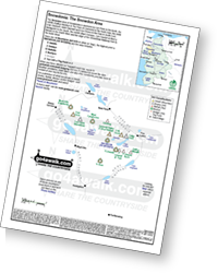
Example shown: Snowdon Area of The Snowdonia National Park which includes Mount Snowdon (Yr Wyddfa), The Highest Mountain in Wales.
Peak Bagging The Mountains in Wales is a way of discovering and experiencing new mountains, peaks, tops and hills that you might not otherwise have thought of walking on - often in glorious solitude well away from the crowded honeypots.
It can be a lot of fun and immensely satisfying too!
Peak Bagging The Mountains in Wales - How to get started.
Peak Bagging Location Maps detailing all the Mountains, Peaks, Tops and Hills in a particular area are available in selected areas now to print and/or save to your phone so you can view it anytime without needing a signal.
To see which Peak Bagging Location Maps are currently available - click here
A free example peak bagging map is available via a link in the current edition of our regular newsletter - click here to get your copy now!


