Interactive Peak Bagging Map: The Lake District The Western Fells
The Lake District Western Fells are enlosed by:
- The edge of The Lake District National Park from Egremont to Cockermouth to the North West
- Lorton Vale, Crummock Water, Buttermere and Honister Pass to the North East
- Sty Head Pass and Wasdale to the South East
- An imaginary line from the Southern Tip of Wast Water to Egremont to the South West
If you count only the Wainwrights there are 33 tops to climb, bag & conquer and the highest point is Great Gable at 899m (2,951ft).
To see these Mountains, Peaks, Tops and Hills displayed in different ways - see the options in the left-hand column and towards the bottom of this page.
 Your Personal Bagging Record for The Western Fells area of The Lake District
Log On and Reload this page to show which Mountains, Peaks, Tops and Hills you have already climbed, bagged & conquered [. . . more details]
Interactive Map of Mountains, Peaks, Tops and Hills in The Western Fells area of The Lake District
How to Load this interactive map: Due to usage restrictions, you must be Registered and Logged-On to go4awalk.com to view and use the interactive Google Map below. You do not need to purchase any credits, but you must be Registered and Logged-On. NB If you want to record which Mountains, Peaks, Tops and Hills you have sucessfully climber and bagged, you will will need one credit to activate your Personal Mountain Bagging Record (PMBR).
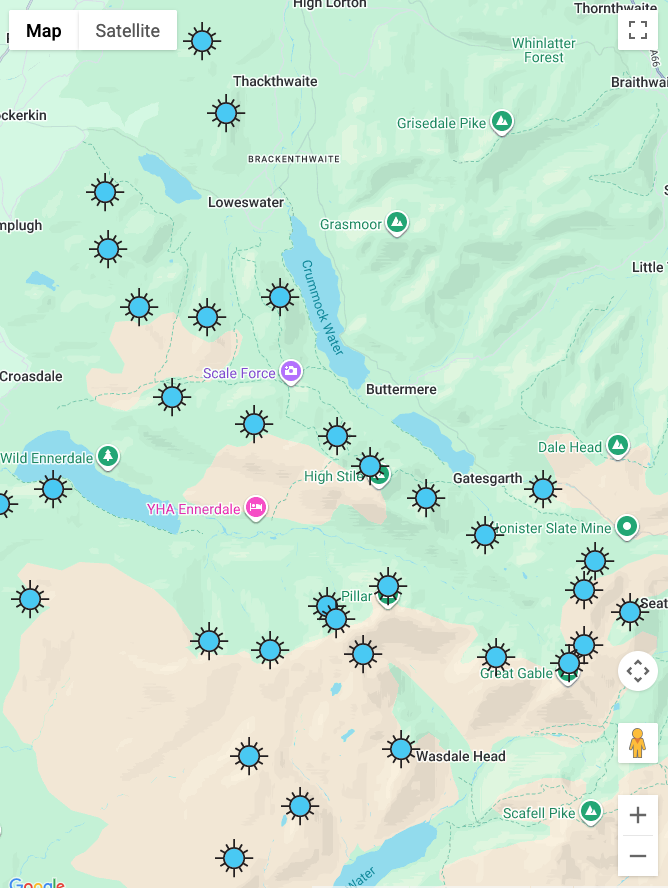
Scroll down this list of mountains, peaks, tops & hills below and tap/click on each name (in blue) to locate it's position on the map above.
See this list in: Alphabetical Order | Height Order‡
To reverse the order select the link again.
Mountain, Peak, Top or Hill:
Bagged


1. Great Gable
899m (2,951ft)
Wainwright
See more details, photos, trip reports and easy-to-follow walks up Great Gable
2. Pillar
892m (2,928ft)
Wainwright
See more details, photos, trip reports and easy-to-follow walks up Pillar
3. Scoat Fell (Little Scoat Fell)
841m (2,759ft)
Wainwright
See more details, photos, trip reports and easy-to-follow walks up Scoat Fell (Little Scoat Fell)
4. Red Pike (Wasdale)
826m (2,711ft)
Wainwright
See more details, photos, trip reports and easy-to-follow walks up Red Pike (Wasdale)
5. Steeple
819m (2,688ft)
Wainwright
See more details, photos, trip reports and easy-to-follow walks up Steeple
6. High Stile
807m (2,646ft)
Wainwright
See more details, photos, trip reports and easy-to-follow walks up High Stile
7. Kirk Fell
802m (2,631ft)
Wainwright
See more details, photos, trip reports and easy-to-follow walks up Kirk Fell
8. Green Gable
801m (2,629ft)
Wainwright
See more details, photos, trip reports and easy-to-follow walks up Green Gable
9. Haycock
797m (2,616ft)
Wainwright
See more details, photos, trip reports and easy-to-follow walks up Haycock
10. Red Pike (Buttermere)
755m (2,478ft)
Wainwright
See more details, photos, trip reports and easy-to-follow walks up Red Pike (Buttermere)
11. High Crag (Buttermere)
744m (2,442ft)
Wainwright
See more details, photos, trip reports and easy-to-follow walks up High Crag (Buttermere)
12. Brandreth
715m (2,346ft)
Wainwright
See more details, photos, trip reports and easy-to-follow walks up Brandreth
13. Caw Fell
697m (2,288ft)
Wainwright
See more details, photos, trip reports and easy-to-follow walks up Caw Fell
14. Grey Knotts
697m (2,287ft)
Wainwright
See more details, photos, trip reports and easy-to-follow walks up Grey Knotts
15. Seatallan
692m (2,271ft)
Wainwright
See more details, photos, trip reports and easy-to-follow walks up Seatallan
16. Fleetwith Pike
648m (2,126ft)
Wainwright
See more details, photos, trip reports and easy-to-follow walks up Fleetwith Pike
17. Base Brown
646m (2,120ft)
Wainwright
See more details, photos, trip reports and easy-to-follow walks up Base Brown
18. Starling Dodd
633m (2,077ft)
Wainwright
See more details, photos, trip reports and easy-to-follow walks up Starling Dodd
19. Yewbarrow
628m (2,062ft)
Wainwright
See more details, photos, trip reports and easy-to-follow walks up Yewbarrow
20. Great Borne
616m (2,021ft)
Wainwright
See more details, photos, trip reports and easy-to-follow walks up Great Borne
21. Hay Stacks (Haystacks)
597m (1,959ft)
Wainwright
See more details, photos, trip reports and easy-to-follow walks up Hay Stacks (Haystacks)
22. Middle Fell (Wasdale)
582m (1,910ft)
Wainwright
See more details, photos, trip reports and easy-to-follow walks up Middle Fell (Wasdale)
23. Blake Fell
573m (1,881ft)
Wainwright
See more details, photos, trip reports and easy-to-follow walks up Blake Fell
24. Lank Rigg
541m (1,775ft)
Wainwright
See more details, photos, trip reports and easy-to-follow walks up Lank Rigg
25. Gavel Fell
526m (1,726ft)
Wainwright
See more details, photos, trip reports and easy-to-follow walks up Gavel Fell
26. Crag Fell
523m (1,716ft)
Wainwright
See more details, photos, trip reports and easy-to-follow walks up Crag Fell
27. Mellbreak
512m (1,680ft)
Wainwright
See more details, photos, trip reports and easy-to-follow walks up Mellbreak
28. Hen Comb
509m (1,670ft)
Wainwright
See more details, photos, trip reports and easy-to-follow walks up Hen Comb
29. Grike
488m (1,602ft)
Wainwright
See more details, photos, trip reports and easy-to-follow walks up Grike
30. Burnbank Fell
475m (1,559ft)
Wainwright
See more details, photos, trip reports and easy-to-follow walks up Burnbank Fell
31. Low Fell
423m (1,388ft)
Wainwright
See more details, photos, trip reports and easy-to-follow walks up Low Fell
32. Fellbarrow
416m (1,365ft)
Wainwright
See more details, photos, trip reports and easy-to-follow walks up Fellbarrow
33. Buckbarrow
405m (1,329ft)
Wainwright
See more details, photos, trip reports and easy-to-follow walks up Buckbarrow
See this list in: Alphabetical Order | Height Order‡
To reverse the order select the link again.
View these 33 Mountains, Peaks, Tops and Hills:
- On a Downloadable PDF you can Print or Save to your Phone#
- On an Interactive Google Map with a list of tops below it.
(makes it easier to locate a particular top) - On a Detailed List in:
Alphabetical Order | Height Order - On one page with 'yet-to-be-bagged' listed 1st
& then 'already-bagged' tops listed 2nd in:
Alphabetical Order | Height Order - On one page with 'already-bagged' tops listed 1st
& then 'yet-to-be-bagged' tops listed 2nd in:
Alphabetical Order | Height Order
 The view from Great Gable
Photo: Ian Mansell
# Whether you print a copy or download it to your phone, this Peak Baggers' Map will prove incredibly useful if you want to know what's what when you are up in the mountains and cannot get a phone signal.
Is there a Mountain, Peak, Top or Hill missing from the above google map or list?
Let us know an we will add it to our database.

To contribute to go4awalk.com or to contact us about anything at all - see Talk To Us.
For help see Help.
go4awalk.com and go4awalk.co.uk are registered trademarks of TMDH Limited.
Copyright © 2000-2026 TMDH Limited. All rights reserved.
Copyright Terms & Conditions Privacy Statement
A - Z Walks Home Log On/Accounts Photo Gallery Walk Ideas and Collections Fell Facts Hill Skills Walking Questions and Answers Your Stories News Competitions Product Reviews/Gear Tests Walking Gear Guides Peaks and Mountains Peak Bagging Find New Walking Friends Camping GPS Waypoints for Walking Contents Walk Search Talk To Us go4awalk.com Help Free Example Walks Newsletter