UK Postcode NE49 - The 30 nearest easy-to-follow, circular walk route maps to you
The thirty nearest easy-to-follow, circular walk route maps to you in UK Postcode NE49 in Walk Grade Order
The UK cities, towns and villages in Northumberland, England that have NE49 in their UK Postcode include:
• Haltwhistle • Melkridge • Plenmeller • Rowfoot • Stonehouse •
Not familiar with the area around NE49?
See these 30 nearest walks to UK Postcode NE49 on a google map
   |
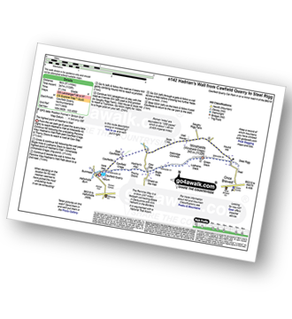
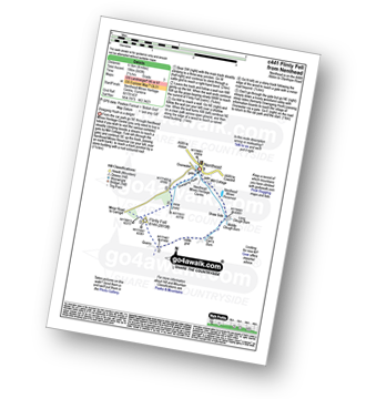
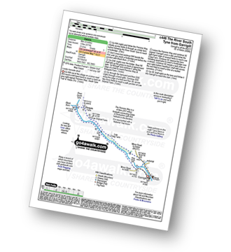
Vital Statistics:
| Length: | 8.5 miles (13.5 km) |
| Ascent: | 804ft (245m) |
| Time: | 4 hrs |
| Grade: |  |

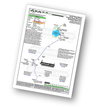
Route Summary:
Haltwhistle - Wydon Farm - Wydon Eals Farm - River South Tyne - Featherstone Castle - Lambley Viaduct Nature Trail - Thorneyhole Wood - Featherstone Rowfoot - Park Village - Broomhouse Farm - Haltwhistle
|
Vital Statistics:
| Length: | 5.5 miles (9 km) |
| Ascent: | 1,138ft (347m) |
| Time: | 3½ hrs |
| Grade: | |
Route Summary:
Cawfield Quarry Car Park - Hadrian's Wall - The Pennine Way - The Hadrian's Wall Path - Cawfield Crags - Thorny Doors - Caw Gap - Bogle Hole - Lodhams Slack - Winshields (Winshield Crags) - Green Slack - Steel Rigg - Hound Hill - Melkridge Common - East Cawfields - Cawfields - Cawfield Quarry Car Park
|
Vital Statistics:
| Length: | 8.25 miles (13 km) |
| Ascent: | 1,460ft (445m) |
| Time: | 4½ hrs |
| Grade: |  |

Route Summary:
Housteads Visitor Centre - Chapel Hill - Housesteads - Vercovicium Fort - The Hadrian's Wall Path - Housesteads Crags - Cuddy's Crag - The Pennine Way - Hotbank Crags - Hotbank - Crag Lough - Highshield Crags - Steel Rigg - Peel Crags - Peel - Once Brewed - Brackies Burn - Smith's Shield - Causeway House - Vindolanda Roman Fort - Chesterholm - Barcombe - East Crindledykes Farm - Green Brae - Little Shield - Deafley Rigg - Housteads Visitor Centre
|
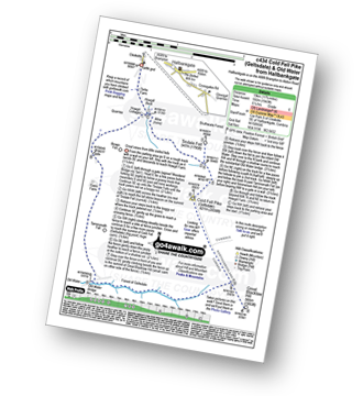
Vital Statistics:
| Length: | 5.75 miles (9 km) |
| Ascent: | 1,480ft (451m) |
| Time: | 3.75hrs |
| Grade: | |
Route Summary:
Clesketts - Tortie Farm - Howgill Cottages - Tindale Fells - Howgill Beck - Cold Fell Pike (Geltsdale) - Tindale Fell - Tindale Tarn - Thron Farm - Clesketts
|
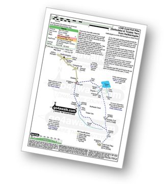
Vital Statistics:
| Length: | 11.75 miles (19 km) |
| Ascent: | 1,943ft (592m) |
| Time: | 6.25hrs |
| Grade: |  |
Route Summary:
Clesketts - Tortie Farm - Howgill Cottages - Tindale Fells - Howgill Beck - Tindale Fell - Cold Fell Pike (Geltsdale) - Great Blacklaw Hill - Old Water - Old Water Bridge - Gairs Farm - Howgill Cottages - Clesketts
|
Vital Statistics:
| Length: | 10 miles (16 km) |
| Ascent: | 1,628ft (496m) |
| Time: | 5.25hrs |
| Grade: | |

Route Summary:
Gilderdale Bridge - The Pennine Way - Black Hill (Whitley Common) - Grey Nag - Tom Smith's Stone Top - Tom Smith's Stone - Croglin Water - Haresceugh Fell - Black Fell (Haresceugh Fell) - Woldgill Moss - Gilderdale Burn - Gilderdale Bridge
|
Vital Statistics:
| Length: | 6.25 miles (10 km) |
| Ascent: | 1,325ft (404m) |
| Time: | 3½ hrs |
| Grade: | |

Route Summary:
Gilderdale Bridge - Gilderdale Burn - The Pennine Way - Whitley Castle - Black Hill (Whitley Common) - Grey Nag - Black Hill (Whitley Common) - Whitley Castle - The Pennine Way - Gilderdale Burn - Gilderdale Bridge
|
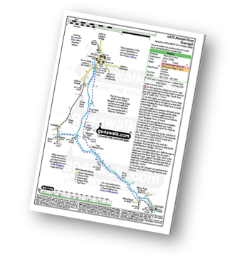
Vital Statistics:
| Length: | 4.75 miles (7.5 km) |
| Ascent: | 479ft (146m) |
| Time: | 2.25hrs |
| Grade: |  |
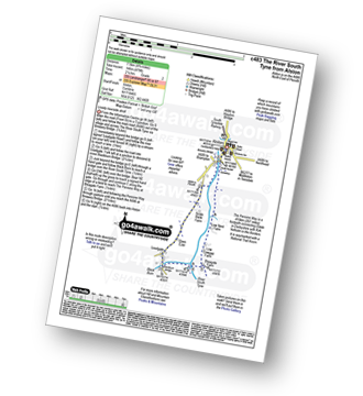
Route Summary:
Alston - Leadgate - Blackburn Bridge - Bleagate Farm - The Pennine Way - Low Nest Farm - Alston
|
Vital Statistics:
| Length: | 4 miles (6.5 km) |
| Ascent: | 643ft (196m) |
| Time: | 2.25hrs |
| Grade: |  |
Route Summary:
Nenthead - Nenthead Mines Heritage Centre - Shaw Side - Old Carr's Burn - Flinty Fell - Dowgang Hush - Nenthead
|
Vital Statistics:
| Length: | 6.25 miles (10 km) |
| Ascent: | 821ft (250m) |
| Time: | 3.25hrs |
| Grade: | |
Route Summary:
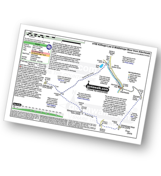
Killhope Cross - Killhope Head - Black Hill - The Dodd - Smallburns Moor - Sunnyside Farm - Coalcleugh Farm - Mufton Hall - Carrshield Moor - Bridge Cleugh - Killhope Law - Killhope Head - Killhope Cross
|
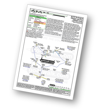
Vital Statistics:
| Length: | 8.75 miles (14 km) |
| Ascent: | 798ft (243m) |
| Time: | 4 hrs |
| Grade: | |
Route Summary:
Garrigill - The Pennine Way - The South Tyne Trail - The River South Tyne - Low Sillyhall Farm - Bleagate Farm - Low Cowgap Farm - Low Nest Farm - Brewery Bridge - Alston - Crosslands - Leadgate - Blackburn Bridge - Garrigill
|
Vital Statistics:
| Length: | 10.25 miles (16.5 km) |
| Ascent: | 1,408ft (429m) |
| Time: | 5.25hrs |
| Grade: | |
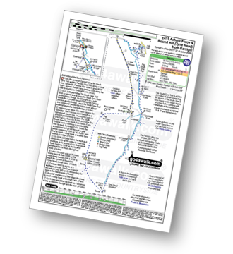
Route Summary:
Garrigill - The Pennine Way - The South Tyne Trail - Low Crossgill - Ash Gill - Ashgill Force - Waterfall - Hole House Farm - Tynehead Farm - Tyne Head - Round Hill (Tyne Head) - Noonstones Hill - Dorthgill Farm - Hill House Farm - Lee Houses - Garrigill
|
Vital Statistics:
| Length: | 10 miles (16 km) |
| Ascent: | 1,359ft (414m) |
| Time: | 4 hrs |
| Grade: | |

Route Summary:
Garrigill - The Pennine Way - The South Tyne Trail - Low Crossgill - Ash Gill - Ashgill Force - Waterfall - Hole House Farm - Tynehead Farm - Allan's Clough - Bellbeaver Rigg (Tynehead Fell) - Tyne Head - Garrigill
|
Vital Statistics:
| Length: | 5 miles (8 km) |
| Ascent: | 571ft (174m) |
| Time: | 2½ hrs |
| Grade: | |
Route Summary:
Garrigill - The Pennine Way - The River South Tyne - Black Burn - Bleagate Farm - Low Sillyhall Farm - Low Craig Farm - Garrigill
|
Vital Statistics:
| Length: | 11 miles (17.5 km) |
| Ascent: | 1,766ft (538m) |
| Time: | 5.75hrs |
| Grade: | |

Route Summary:
Garrigill - The Pennine Way - The South Tyne Trail - Low Crossgill - Ash Gill - Ashgill Force - Waterfall - Hole House Farm - Tynehead Farm - Allan's Clough - Bellbeaver Rigg (Tynehead Fell) - Tyne Head - Round Hill (Tyne Head) - Noonstones Hill - Dorthgill Farm - Hill House Farm - Lee Houses - Garrigill
Not familiar with the area around NE49?
See these 30 nearest walks to UK Postcode NE49 on a google map
|
Vital Statistics:
| Length: | 20 miles (32 km) |
| Ascent: | 2,905ft (885m) |
| Time: | 10 hrs |
| Grade: |  |

Route Summary:
Garrigill - The Pennine Way - The South Tyne Trail - Low Crossgill - Ash Gill - Ashgill Force - Hole House Farm - Tynehead Farm - Tyne Head - River Tees - Dunfell Hush - Great Dun Fell - Little Dun Fell - Cross Fell - Skirwith Fell - Yad Stone - Greg's Hut (bothy) - Backstone Edge (Lambgreen Hills) - Long Man Hill - Meg Moffat's Hill - Black Band - Garrigill
|
Vital Statistics:
| Length: | 6.28 miles (10 km) |
| Ascent: | 666ft (203m) |
| Time: | 3 hrs |
| Grade: | |
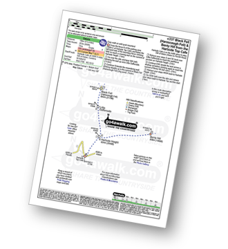
Route Summary:
Hartside Top Cafe - Hartside Height - Little Daffenside - Black Fell (Haresceugh Fell) - Little Daffenside - Hartside Height - Benty Hill - Hartside Height - Hartside Top Cafe
|
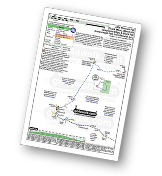
Vital Statistics:
| Length: | 4 miles (6.5 km) |
| Ascent: | 1,293ft (394m) |
| Time: | 2.75hrs |
| Grade: | |
|
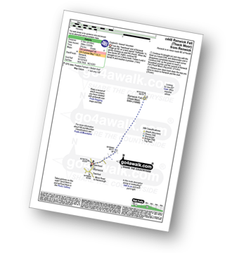
Vital Statistics:
| Length: | 10.25 miles (16.5 km) |
| Ascent: | 2,002ft (610m) |
| Time: | 5.75hrs |
| Grade: | |
Route Summary:
Renwick - Townend - Renwick Fell (Thack Moor) - Watch Hill (Graystone Edge) - Black Fell (Haresceugh Fell) - Little Daffenside - Hartside Height - Hartside Top Cafe (A686) - Ricker Gill - Seavy Sike - Haresceugh - Raven Bridge - Townfoot - Renwick
|
Vital Statistics:
| Length: | 12.75 miles (20.5 km) |
| Ascent: | 1,759ft (536m) |
| Time: | 6½ hrs |
| Grade: | |

Route Summary:
Allenheads - Dirt Pots - The Weardale Way - Killhope Law - Shivery Hill - Carshield Moor - Scum Hill - Hartley Moor - Nan Davison's Cleugh - Philipson's Fold - Knockshield Moor - Black Way (Track) - Swinhope Shield - High Knock Shield - Knock Shield - Knockburn Farm - River East Allen - Low Sipton Shield - Sipton Terrace - Teedham Green - Corn Mill - Low Huntwell - Dirt Pots - Allenheads
|
Vital Statistics:
| Length: | 9.5 miles (15 km) |
| Ascent: | 1,378ft (420m) |
| Time: | 4.75hrs |
| Grade: | |
Route Summary:
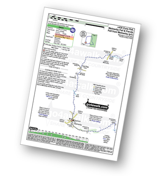
Allenheads - Dirt Pots - The Weardale Way - Killhope Law - Stangend Currick - Middlehope Moor - Shorngate Cross - Allenheads
|
Vital Statistics:
| Length: | 8.5 miles (13.5 km) |
| Ascent: | 945ft (288m) |
| Time: | 4 hrs |
| Grade: | |

Route Summary:
Hawkhope Car Park - Starsley Burn - Falstone Mine - Flastone Forest - Belling Burn - Goodwell Syke - Soney Gap - Plashetts Incline Jetty - Kielder Water - Benny Shanks Jetty - Pot Burn - Cock Soor - Whinny Hill - Belling Burn - The Belling - Bastle - Kielder Water Dam - Hawkhope Car Park
|
Vital Statistics:
| Length: | 11 miles (17.5 km) |
| Ascent: | 2,288ft (697m) |
| Time: | 6.25hrs |
| Grade: | |
Route Summary:
Melmerby - Meikle Awfell - Cuns Fell - Maiden Way (Roman Road) - Meg's Cairn - Melmerby Fell - Knapside Hill - Little Knapside Hill - Fiend's Fell - Twotop Bridge - Hazel Rigg Farm - Gamblesby - Gill Beck - Melmerby
|
Vital Statistics:
| Length: | 11.5 miles (18.5 km) |
| Ascent: | 1,631ft (497m) |
| Time: | 5.75hrs |
| Grade: | |
Route Summary:
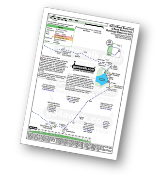
Burnhope Reservoir - Ireshope Moor - Coldberry End - Great Stony Hill - Scaud Hill - Redgleam (Harwood Common) - Burnhope Seat - Dead Stones - White Edge (Burnhope Reservoir) - Lamb's Head - Highwatch Currick - The Malakoff - Bents Head - Stripe End - Burnhope Reservoir
|
Vital Statistics:
| Length: | 14 miles (22.5 km) |
| Ascent: | 1,904ft (580m) |
| Time: | 7 hrs |
| Grade: |  |
Route Summary:
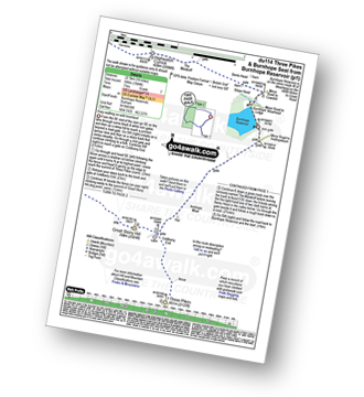
Burnhope Reservoir - Ireshope Moor - Coldberry End - Three Pikes - Coldberry End - Great Stony Hill - Scaud Hill - Redgleam (Harwood Common) - Burnhope Seat - Dead Stones - White Edge (Burnhope Reservoir) - Lamb's Head - Highwatch Currick - The Malakoff - Bents Head - Stripe End - Burnhope Reservoir
|
Vital Statistics:
| Length: | 7.5 miles (12 km) |
| Ascent: | 1,287ft (392m) |
| Time: | 4 hrs |
| Grade: | |
Route Summary:
Burnhope Reservoir - Ireshope Moor - Coldberry End - Three Pikes - Coldberry End - Great Stony Hill - Coldberry End - Ireshope Moor - Burnhope Reservoir
|
Vital Statistics:
| Length: | 9 miles (14.5 km) |
| Ascent: | 1,651ft (503m) |
| Time: | 5 hrs |
| Grade: | |

Route Summary:
St John's Chapel - Thatch Mires - Chapelfell Top - Fendrith Hill - Swinhope Moor - Dora's Seat - Swinhope Head - Swinside House - Daddry Shield - River Wear - Weardale - The Weardale Way - St John's Chapel
|
Vital Statistics:
| Length: | 14 miles (22.5 km) |
| Ascent: | 1,979ft (603m) |
| Time: | 7 hrs |
| Grade: | |

Route Summary:
St John's Chapel - Thatch Mires - Chapelfell Top - Fendrith Hill - Swinhope Moor - Dora's Seat - Swinhope Head - Westernhope Moor - Black Hill (Westernhope Moor) - Littlewood Farm - Brotherlee - Shield - River Wear - Weardale - The Weardale Way - Westgate - Daddry - St John's Chapel
|
Vital Statistics:
| Length: | 10.75 miles (17 km) |
| Ascent: | 2,437ft (743m) |
| Time: | 6 hrs |
| Grade: | |

Route Summary:
Kirkland - Kirkland Beck - Cocklick Scar - Plylier's Gap - High Cap - Ironwell Band - The Pennine Way - Cross Fell - Crowdundle Head - Tees Head - Sturba Nook - Wildboar Scar - Grumply Hill - Littledale Beck - Cringle Moor - Blencarn - Blencarn Lake - Blencarn Beck - Kirk Hill - Kirkland
|
Vital Statistics:
| Length: | 15.75 miles (23.5 km) |
| Ascent: | 1,835ft (559m) |
| Time: | 7.25hrs |
| Grade: | |
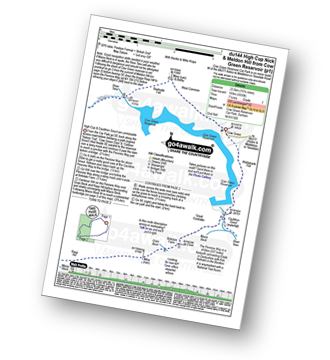
Route Summary:
Cow Green Reservoir - Widdybank Fell - Cauldron Snout - The Pennine Way - Birkdale Farm - Grain Beck - Rasp Hill - Maize Beck - High Cup - High Cup Nick - Stake Beck - Meldon Hill (Dufton Fell) - Force Burn - River Tees - Backside Fell Bothy - Cow Green Reservoir
Not familiar with the area around NE49?
See these 30 nearest walks to UK Postcode NE49 on a google map


