Seven easy to follow circular walk route maps from Garrigill in the The North Pennines, Cumbria, England
   |
Vital Statistics:
| Length: | 5 miles (8 km) |
| Ascent: | 571ft (174m) |
| Time: | 2½ hrs |
| Grade: |  |
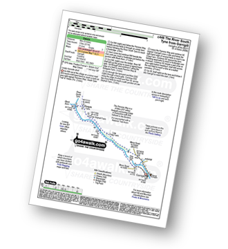
Route Summary:
Garrigill - The Pennine Way - The River South Tyne - Black Burn - Bleagate Farm - Low Sillyhall Farm - Low Craig Farm - Garrigill
|
Vital Statistics:
| Length: | 8.75 miles (14 km) |
| Ascent: | 798ft (243m) |
| Time: | 4 hrs |
| Grade: |  |
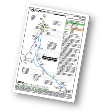
Route Summary:
Garrigill - The Pennine Way - The South Tyne Trail - The River South Tyne - Low Sillyhall Farm - Bleagate Farm - Low Cowgap Farm - Low Nest Farm - Brewery Bridge - Alston - Crosslands - Leadgate - Blackburn Bridge - Garrigill
|
Vital Statistics:
| Length: | 10.25 miles (16.5 km) |
| Ascent: | 1,408ft (429m) |
| Time: | 5.25hrs |
| Grade: |  |
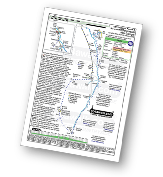
Route Summary:
Garrigill - The Pennine Way - The South Tyne Trail - Low Crossgill - Ash Gill - Ashgill Force - Waterfall - Hole House Farm - Tynehead Farm - Tyne Head - Round Hill (Tyne Head) - Noonstones Hill - Dorthgill Farm - Hill House Farm - Lee Houses - Garrigill
|
Vital Statistics:
| Length: | 10 miles (16 km) |
| Ascent: | 1,359ft (414m) |
| Time: | 4 hrs |
| Grade: | |

Route Summary:
Garrigill - The Pennine Way - The South Tyne Trail - Low Crossgill - Ash Gill - Ashgill Force - Waterfall - Hole House Farm - Tynehead Farm - Allan's Clough - Bellbeaver Rigg (Tynehead Fell) - Tyne Head - Garrigill
|
Vital Statistics:
| Length: | 11 miles (17.5 km) |
| Ascent: | 1,766ft (538m) |
| Time: | 5.75hrs |
| Grade: |  |

Route Summary:
Garrigill - The Pennine Way - The South Tyne Trail - Low Crossgill - Ash Gill - Ashgill Force - Waterfall - Hole House Farm - Tynehead Farm - Allan's Clough - Bellbeaver Rigg (Tynehead Fell) - Tyne Head - Round Hill (Tyne Head) - Noonstones Hill - Dorthgill Farm - Hill House Farm - Lee Houses - Garrigill
|
Vital Statistics:
| Length: | 15.75 miles (25 km) |
| Ascent: | 2,343ft (714m) |
| Time: | 8 hrs |
| Grade: |  |

Route Summary:
Garrigill - The Pennine Way - The South Tyne Trail - Low Crossgill - Ash Gill - Ashgill Force - Waterfall - Hole House Farm - Tynehead Farm - Allan's Clough - Bellbeaver Rigg (Tynehead Fell) - Tyne Head - Round Hill (Tyne Head) - Crossgill Head - Crossgill Pants - Rake End - Lambgreen Hills - Bullman Hills - Bullman Hills (North Top) - Bullman Sike - Cash Burn - Long Man Hill - Craglands Sike - Pikeman Hill - Meg Moffat's Hill - Black Band - Garrigill
|
Vital Statistics:
| Length: | 20 miles (32 km) |
| Ascent: | 2,905ft (885m) |
| Time: | 10 hrs |
| Grade: |  |

Route Summary:
Garrigill - The Pennine Way - The South Tyne Trail - Low Crossgill - Ash Gill - Ashgill Force - Hole House Farm - Tynehead Farm - Tyne Head - River Tees - Dunfell Hush - Great Dun Fell - Little Dun Fell - Cross Fell - Skirwith Fell - Yad Stone - Greg's Hut (bothy) - Backstone Edge (Lambgreen Hills) - Long Man Hill - Meg Moffat's Hill - Black Band - Garrigill


