
![]()
Black Fell (Haresceugh Fell)
664m (2179ft)
The North Pennines, Cumbria, England
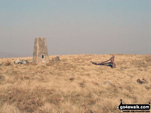
The summit of Black Fell (Haresceugh Fell) is marked by an Ordnance Survey Trig Point.

Not familiar with this top?
You can walk/hike to the top of Black Fell (Haresceugh Fell) by using either of these 2 easy‑to‑follow route maps:
Walk c337 Black Fell (Haresceugh Fell) and Benty Hill from Hartside Top Cafe
Easy walk on wild moorland
   |
|---|
Vital Statistics:
| Length: | 6.28ml (10km) |
|---|---|
| Ascent: | 666ft (203m) |
| Time: | 3 hrs |
| Grade: |  (Moderate) (Moderate) |
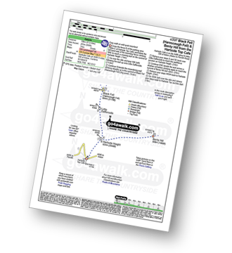
Route Summary:
Hartside Top Cafe - Hartside Height - Little Daffenside - Black Fell (Haresceugh Fell) - Little Daffenside - Hartside Height - Benty Hill - Hartside Height - Hartside Top Cafe
Walk c308 Renwick Fell (Thack Moor), Watch Hill and Black Fell (Haresceugh Fell) from Renwick
Wild quiet moorland
|
|---|
Vital Statistics:
| Length: | 10.25ml (16.5km) |
|---|---|
| Ascent: | 2,002ft (610m) |
| Time: | 5.75hrs |
| Grade: |  (Moderate) (Moderate) |
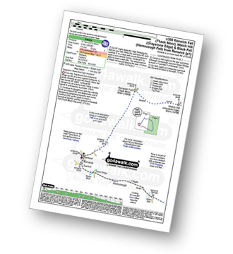
Route Summary:
Renwick - Townend - Renwick Fell (Thack Moor) - Watch Hill (Graystone Edge) - Black Fell (Haresceugh Fell) - Little Daffenside - Hartside Height - Hartside Top Cafe (A686) - Ricker Gill - Seavy Sike - Haresceugh - Raven Bridge - Townfoot - Renwick
See Black Fell (Haresceugh Fell) and the surrounding tops on our free-to-access 'Google Style' Peak Bagging Map:
The North Pennines
Less data - quicker to download
See Black Fell (Haresceugh Fell) and the surrounding tops on our unique, downloadable, PDF Peak Bagging Map:

NB: Whether you print off a copy or download it to your phone, this PDF Peak Baggers' Map might prove incredibly useful when your are up there on the tops and you cannot get a phone signal.
You can find Black Fell (Haresceugh Fell) & all the walks that climb it on these unique free-to-access Interactive Walk Planning Maps:
1:25,000 scale OS Explorer Map (orange/yellow covers):
1:50,000 scale OS Landranger Map (pink/magenta covers):
 Fellow go4awalkers who have already walked, climbed, scaled, summited, hiked & bagged Black Fell (Haresceugh Fell)
David Peebles walked up Black Fell (Haresceugh Fell) on July 13th, 2024 [from/via/route] Bridge near Gilderdale Bridge [with] Solo walk [weather] Rained most of the day. - New boots. Sore heels by the end. Broken in now after 18km hopefully.
Kate Barnes climbed it on September 9th, 2023 [from/via/route] Nightmare, no paths, not possible to walk NW bank Grindale Burn [with] K & P [weather] Hot
Sam Jones bagged it on March 26th, 2022 [from/via/route] From Hartside [with] Solo [weather] pleasant day reasonably bright - Awesome views
Mark Davidson hiked Black Fell (Haresceugh Fell) on March 23rd, 2007 [from/via/route] Walk c337 Black Fell (Haresceugh Fell) & Benty Hill from Hartside Top Cafe [with] alone [weather] Bright & sunny - lovely summer's day - Loved it (loved it!)
Caroline Winter summited on August 19th, 2021 [from/via/route] A686/Hartside Cross CP, fence line to Black Fell [with] Becky [weather] Drizzly, low cloud on top - CP Great spot of surrounding landscape & road a bikers paradise. Straight forward walk to reach top
To add (or remove) your name and experiences on this page - Log On and edit your Personal Mountain Bagging Record
. . . [see more walk reports]
More Photographs & Pictures of views from, on, or of, Black Fell (Haresceugh Fell)


Sun and snow on Skiddaw and Blencathra from Black Fell (Haresceugh Fell)

Black Fell (Haresceugh Fell) and the A686 near Hartside Cafe from Fiend's Fell
Send us your photographs and pictures on, of, or from Black Fell (Haresceugh Fell)
If you would like to add your walk photographs and pictures to this page, please send them as email attachments (configured for any computer) along with your name to:
and we shall do our best to publish them.
(Guide Resolution = 300dpi. At least = 660pixels (wide) x 440 pixels (high).)

You can also submit photos via our Facebook Page.
NB. Please indicate where each photo was taken and whether you wish us to credit your photos with a Username or your First Name/Last Name.


