UK Postcode CA16 - The 30 nearest easy-to-follow, circular walk route maps to you
The thirty nearest easy-to-follow, circular walk route maps to you in UK Postcode CA16 in Walk Grade Order
The UK cities, towns and villages in Cumbria, England that have CA16 in their UK Postcode include:
• Appleby-in-Westmorland • Bleatarn • Bolton • Brackenber • Brampton • Burrells • Colby • Coupland • Crackenthorpe • Drybeck • Dufton • Great Asby • Great Ormside • Hilton • Hoff • Keisley • Knock • Long Marton • Murton • Sandford • Warcop •
Not familiar with the area around CA16?
See these 30 nearest walks to UK Postcode CA16 on a google map
   |
Vital Statistics:
| Length: | 15.75 miles (25 km) |
| Ascent: | 2,918ft (889m) |
| Time: | 8.75hrs |
| Grade: |  |

Route Summary:
Hilton Town Head - Hilton Beck - Warcop Training Area - Swindale Brow - Swindale Beck - Swindale Edge - Marn Gill - Christy Bank - Siss Gill - Burton Fell - Little Fell (Burton Fell) - Hilton Fell - Arnside Rake - King's Pot - Mickle Fell - Fisher Sike - Maize Beck - Swarth Beck - Master Sike - Murton Fell - Murton Fell (SE Top) - Scordale - Lowfield Hush - Hilton Town Head
|
Vital Statistics:
| Length: | 5 miles (8 km) |
| Ascent: | 703ft (214m) |
| Time: | 2½ hrs |
| Grade: |  |

Route Summary:
Dufton - The Pennine Way - Eller Beck - Church Bridge - Knock Church - Swindale Beck - Knock - Cosca Hill - Great Rundale Beck - Pisgill House - Dufton
|
Vital Statistics:
| Length: | 11.25 miles (18 km) |
| Ascent: | 2,206ft (672m) |
| Time: | 6.25hrs |
| Grade: |  |

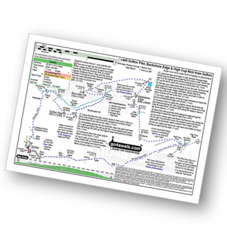
Route Summary:
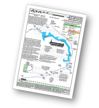
Dufton - Eller Beck - Pusgill House - Great Rundale Beck - Bluethwaite Hill - Threlkeld Side - Brownber Hill - Tossgill Edge - Great Rundale Tarn - Backstone Edge (Dufton Fell) - Narrowgate Beacon - Little Rundale Beck - High Cup Nick - High Cup - The Pennine Way - Narrow Gate Path - Peeping Hill - Bow Hall - Town Head - Dufton
|
Vital Statistics:
| Length: | 10.75 miles (17 km) |
| Ascent: | 1,976ft (602m) |
| Time: | 6 hrs |
| Grade: | |

Route Summary:
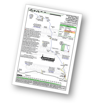
Dufton - The Pennine Way - Town End - Kemplar Bridge - Greenhow Farm - Keisley House - Harbour Flatt Farm - Trundale Gill - Middle Tongue - Murton Fell - Murton Herds - High Cup - High Cup Gill - High Cup Nick - The Pennine Way - Narrow Gate Path - Peeping Hill - Bow Hall - Town Head - Dufton
|
Vital Statistics:
| Length: | 4.75 miles (7.5 km) |
| Ascent: | 1,139ft (347m) |
| Time: | 3 hrs |
| Grade: |  |

Route Summary:
Dufton - The Pennine Way - Eller Beck - Coastsyke Farm (Coatsike Farm) - Hurning Lane - Halsteads - Cosca Hill - Great Rundale Beck - Dufton Pike - Pusgill House - Dufton
|
Vital Statistics:
| Length: | 11.25 miles (18 km) |
| Ascent: | 2,629ft (801m) |
| Time: | 6.75hrs |
| Grade: |  |

Route Summary:
Dufton - The Pennine Way - Coatsyke Farm (Coatsike Farm) - Halsteads - Great Rundale Beck - Cosca Hill - Swindale Beck - Knock Old Man - Knock Fell - Green Castle - Knock Ore Gill - Knock Pike - Swindale Beck - Knock Village - Knock Church - Dufton
|
Vital Statistics:
| Length: | 12.75 miles (20.5 km) |
| Ascent: | 2,819ft (859m) |
| Time: | 7½ hrs |
| Grade: | |
Route Summary:
Dufton - The Pennine Way - Eller Beck - Coastsyke Farm (Coatsike Farm) - Hurning Lane - Halsteads - Cosca Hill - Great Rundale Beck - Dufton Pike - Bluethwaite Hill - Threlkeld Side - Brownber Hill - Tossgill Edge - Great Rundale Tarn - Backstone Edge (Dufton Fell) - Narrowgate Beacon - Little Rundale Beck - High Cup Nick - High Cup - The Pennine Way - Narrow Gate Path - Peeping Hill - Bow Hall - Town Head - Dufton
|
Vital Statistics:
| Length: | 10.75 miles (17 km) |
| Ascent: | 2,437ft (743m) |
| Time: | 6 hrs |
| Grade: | |

Route Summary:
Kirkland - Kirkland Beck - Cocklick Scar - Plylier's Gap - High Cap - Ironwell Band - The Pennine Way - Cross Fell - Crowdundle Head - Tees Head - Sturba Nook - Wildboar Scar - Grumply Hill - Littledale Beck - Cringle Moor - Blencarn - Blencarn Lake - Blencarn Beck - Kirk Hill - Kirkland
|
Vital Statistics:
| Length: | 13.75 miles (22 km) |
| Ascent: | 2,507ft (764m) |
| Time: | 7½ hrs |
| Grade: | |
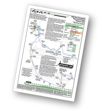
Route Summary:
Kirkby Stephen - Market Square - Frank's Bridge - The River Eden - Ladthwaite Beck - Ewbank Scar - Birkett Hill - Ladthwaite Farm - Faraday Gill - Nine Standards Rigg - White Mossy Hill - Coldbergh Scar - Dukerdale Head - Dukerdale Pots - Rigg Beck - Nateby Common (Tailbridge Hill) - Green Hill - Stank Hill - Great Bell (Long Crag) - Kitchen Gill - B6259 - Nateby - The River Eden - Kirkby Stephen
|
Vital Statistics:
| Length: | 12.5 miles (20 km) |
| Ascent: | 2,127ft (648m) |
| Time: | 6.75hrs |
| Grade: | |
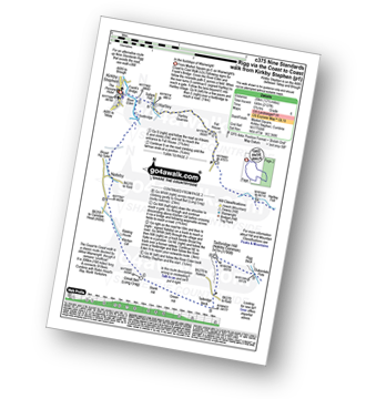
Route Summary:
Kirkby Stephen - Market Square - Frank's Bridge - Hartley - Fell House - Hartley Fell - Faraday Gill - Nine Standards Rigg - White Mossy Hill - Coldbergh Scar - Dukerdale Head - Dukerdale Pots - Rigg Beck - Nateby Common (Tailbridge Hill) - B6270 - Tailbridge Neck - Green Hill - Stank Hill - Great Bell (long Crag) - Kitchen Gill - B6259 - Nateby - The River Eden - Kirkby Stephen
|
Vital Statistics:
| Length: | 5.5 miles (9 km) |
| Ascent: | 1,182ft (360m) |
| Time: | 3.25hrs |
| Grade: | |
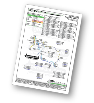
Route Summary:
Kirkby Stephen - Market Square - Frank's Bridge - The River Eden - Ladthwaite Beck - Ewbank Scar - Birkett Hill - Ladthwaite Farm - Fell House - Hartley - Kirkby Stephen
|
Vital Statistics:
| Length: | 15.75 miles (23.5 km) |
| Ascent: | 1,835ft (559m) |
| Time: | 7.25hrs |
| Grade: | |
Route Summary:
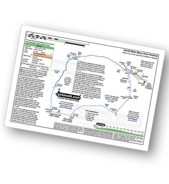
Cow Green Reservoir - Widdybank Fell - Cauldron Snout - The Pennine Way - Birkdale Farm - Grain Beck - Rasp Hill - Maize Beck - High Cup - High Cup Nick - Stake Beck - Meldon Hill (Dufton Fell) - Force Burn - River Tees - Backside Fell Bothy - Cow Green Reservoir
|
Vital Statistics:
| Length: | 7.75 miles (12 km) |
| Ascent: | 1,083ft (330m) |
| Time: | 4 hrs |
| Grade: | |

Route Summary:
B6270 - Tailbridge Neck - Nateby Common (Tailbridge Hill) - Dukerdale Pots - Tollinson Gill - Rollinson Haggs - Boston Gill Head - Nine Standards Rigg - White Mossy Hill - Birk Dale - Birkdale Cross - Birkdale Common - Uldale Beck - Lamps Moss - Tailbridge Neck.
|
Vital Statistics:
| Length: | 9.75 miles (15.5 km) |
| Ascent: | 1,467ft (447m) |
| Time: | 5 hrs |
| Grade: |  |

Route Summary:
B6270 - Tailbridge Neck - Nateby Common (Tailbridge Hill) - Dukerdale Pots - Tollinson Gill - Rollinson Haggs - Boston Gill Head - Nine Standards Rigg - Whitsundale Beck - Ney Gill - Birk Dale - Birkdale Cross - Birkdale Common - Uldale Beck - Lamps Moss - Tailbridge Ne.
|
Vital Statistics:
| Length: | 9.5 miles (15 km) |
| Ascent: | 2,050ft (625m) |
| Time: | 5½ hrs |
| Grade: | |

Route Summary:
Demings Moss - Shap - Whatshaw Common - Little Yarlside - Great Yarlside - Harrop Pike - Grey Crag (Sleddale) - Lord's Seat (Crookdale) - Robin Hood (Crookdale) - High House Bank - Demings Moss - Shap.
Not familiar with the area around CA16?
See these 30 nearest walks to UK Postcode CA16 on a google map
|
Vital Statistics:
| Length: | 11 miles (17.5 km) |
| Ascent: | 2,288ft (697m) |
| Time: | 6.25hrs |
| Grade: | |
Route Summary:
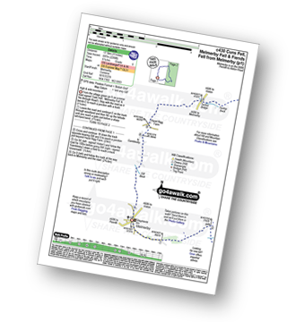
Melmerby - Meikle Awfell - Cuns Fell - Maiden Way (Roman Road) - Meg's Cairn - Melmerby Fell - Knapside Hill - Little Knapside Hill - Fiend's Fell - Twotop Bridge - Hazel Rigg Farm - Gamblesby - Gill Beck - Melmerby
|
Vital Statistics:
| Length: | 14 miles (22.5 km) |
| Ascent: | 1,743ft (531m) |
| Time: | 7 hrs |
| Grade: | |
Route Summary:
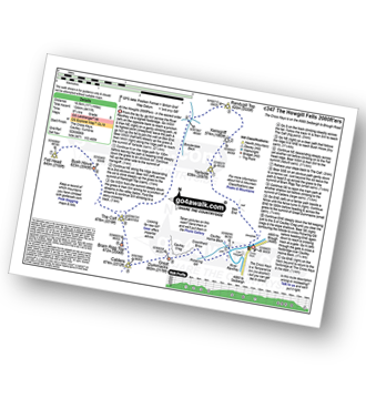
Langdon Beck - Tarn Hole - Tarn Hole Edge - Three Pikes - Grasshill Common - Causeway Hill - Coldberry Edge - Great Stony Hill - Scaud Hill - Redgleam (Harwood Common) - Swallow Hole - Holdenhurth Band - Herdship Fell - Viewing Hill - Backside Fell Bothy - West Common - Touting Hill - Cow Green Reservoir - Widdybank Fell - Langdon Beck
|
Vital Statistics:
| Length: | 7.75 miles (12.5 km) |
| Ascent: | 1,571ft (479m) |
| Time: | 4½ hrs |
| Grade: | |
Route Summary:
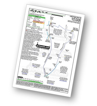
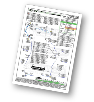
Outhgill - Thrang Beck - The Lady Anne's Way - Hell Gill Bridge - Hell Gill Beck - Hangingstone Scar - Black Fell Moss - Archy Styrigg (Gregory Chapel) - High Seat (Mallerstang) - Mallerstang Edge - Othgill.
|
Vital Statistics:
| Length: | 4.5 miles (7 km) |
| Ascent: | 1,214ft (370m) |
| Time: | 3 hrs |
| Grade: | |

Route Summary:
Hause Bridge Parking Area - Grayrigg Pike - Grayrigg Forest - Repeater Station - Borrowdale Wood - Hause Bridge Parking Area
|
Vital Statistics:
| Length: | 8.25 miles (13 km) |
| Ascent: | 1,572ft (479m) |
| Time: | 4½ hrs |
| Grade: | |

Route Summary:
Huck's Bridge - Ashstead Fell - Mabbin Crag - Castle Fell - Whinfell Beacon - Low Borrowdale - Borrow Beck - High Borrowdale - Borrowdale - Huck's Bridge
|
Vital Statistics:
| Length: | 11 miles (17.5 km) |
| Ascent: | 4,430ft (1,350m) |
| Time: | 8½ hrs |
| Grade: | |

Route Summary:
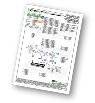
Carlingill Bridge - The Howgills - Carlingill Beck - Carlin Gill - Screes of Black Force - Carlingill Spout - Blakethwaite Bottom - Docker Knott - Great Blea Gill - Simon's Seat (Howgills) - Langdale Beck (Howgills) - Hazelgill Knott - Bowderdale Beck - Bowderdale Head - Cautley Spout - Cautley Crag - Great Dummacks - Little Dummacks - Calders - Bram Rigg Top - The Calf - White Fell Head - Bush Howe - Windscarth Wyke - Breaks Head - Fell Head (Howgills) - Fell Head Scar - Linghaw - Knowles - Back Balk - Gibbet Hill - Carlingill Bridge - The Howgill Fells.
|
Vital Statistics:
| Length: | 4.75 miles (7.5 km) |
| Ascent: | 1,890ft (576m) |
| Time: | 3½ hrs |
| Grade: | |
Route Summary:
Carlingill Bridge - Carlingill Beck - Carlin Gill - Screes of Black Force - Carlingill Spout - Little Ulgill Beck - Black Force - Ulgill Rigg - Fell Head (Howgills) - Linghaw - Knowles - Back Balk - Gibbet Hill - Carlingill Bridge - The Howgill Fells.
|
Vital Statistics:
| Length: | 9.75 miles (15.5 km) |
| Ascent: | 2,038ft (621m) |
| Time: | 5.75hrs |
| Grade: | |
Route Summary:
Thrang Beck - The Lady Anne's Way - Water Cut Sculpture - Hell Gill Bridge - Little Fell (Lunds Fell) (Mallerstang) - Hugh Seat - Black Fell Moss - Archy Styrigg (Gregory Chapel) - High Seat (Mallerstang) - Mallerstang Edge - Outhgill - River Eden - Thrang Beck
|
Vital Statistics:
| Length: | 11.25 miles (18 km) |
| Ascent: | 1,601ft (488m) |
| Time: | 5½ hrs |
| Grade: | |

Route Summary:
Rawthey Bridge - River Rawthey - Holmes Moss - Rawthey Gill - Rawthey Gill Quarry - Rawthey Gill Foot - Baugh Fell (Tarn Rigg Hill) - Broken Gill - Tarn Rigg Hill - Knoutberry Haw - West Baugh Fell Tarn - Raven Thorn - Rawthey Bridge
|
Vital Statistics:
| Length: | 8.5 miles (13.5 km) |
| Ascent: | 1,231ft (375m) |
| Time: | 4½ hrs |
| Grade: | |
Route Summary:
Holwick - Holwick Scars - Rowton Beck - Green Fell - Bink Moss - Dry Gill - Hagworm Hill - Howden Moss - Black Beck - White Rigg - Holwick
|
Vital Statistics:
| Length: | 6 miles (9.5 km) |
| Ascent: | 1,946ft (593m) |
| Time: | 4½ hrs |
| Grade: | |

Route Summary:
The Cross Keys - River Rawthey - Cautley Holme Beck - Cautley Spout - Cautley Crag - Great Dummacks - Little Dummacks - Calders - Bram Rigg Top - The Calf - Bowderdale Beck - Bowderdale Head - Cautley Holme Beck - The Cross Keys
|
Vital Statistics:
| Length: | 11.5 miles (18.5 km) |
| Ascent: | 4,411ft (1,344m) |
| Time: | 8.75hrs |
| Grade: | |
Route Summary:
The Cross Keys - River Rawthey - Ben End - Yarlside - Kensgriff - Randygill Top - Bowderdale Beck - The Calf - Bush Howe - Fell Head (Howgills) - The Calf - Bram Rigg Top - Calders - Cautley Crag - Croonthard Brow - Cautley Holme Beck - River Rawthey - The Cross Keys
|
Vital Statistics:
| Length: | 8 miles (12.5 km) |
| Ascent: | 3,485ft (1,062m) |
| Time: | 6½ hrs |
| Grade: | |

Route Summary:
The Cross Keys - River Rawthey - Ben End - Yarlside - Kensgriff - Randygill Top - Bowderdale Beck - The Calf - Bram Rigg Top - Calders - Great Dummacks - Cautley Crag - Croonthard Brow - Cautley Holme Beck - River Rawthey - The Cross Keys
|
Vital Statistics:
| Length: | 6.5 miles (10.5 km) |
| Ascent: | 2,612ft (796m) |
| Time: | 5 hrs |
| Grade: | |

Route Summary:
The Cross Keys - River Rawthey - Cautley Holme Beck - Cautley Spout - Cautley Crag - Great Dummacks - Little Dummacks - Calders - Bram Rigg Top - The Calf - Bowderdale Beck - Bowderdale Head - Yarlside - Ben End - The Cross Keys
|
Vital Statistics:
| Length: | 8.5 miles (13.5 km) |
| Ascent: | 1,864ft (568m) |
| Time: | 5 hrs |
| Grade: | |

Route Summary:
Needle House Farm - Flint Howe - Sand Tarn - Sandtarn Riggs - Wild Boar Fell - Yoadcomb Scar - High White Scar - The Band (Wild Boar Fell) - Aisgill Head - Standard Brow - Swarth Fell - Swarth Fell Pike - Holmes Moss Hill - Rawthey Gil Foot - Holme Moss - Whin Stone Gill - Blea Gill - Uldale House - Nettlehouse Gill - Needle House Farm
Not familiar with the area around CA16?
See these 30 nearest walks to UK Postcode CA16 on a google map


