
![]()
Wild Boar Fell
708m (2323ft)
The Northern Dales Area, The Yorkshire Dales, Cumbria, England
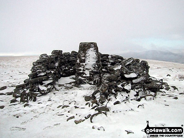
The summit of Wild Boar Fell is marked by an Ordnance Survey Trig Point.

Not familiar with this top?
You can walk/hike to the top of Wild Boar Fell by using either of these 2 easy‑to‑follow route maps:
Walk c282 Wild Boar Fell from Cotegill Bridge
Fine Views from lonely hilltops
   |
|---|
Vital Statistics:
| Length: | 6.25ml (10km) |
|---|---|
| Ascent: | 1,548ft (472m) |
| Time: | 3.75hrs |
| Grade: |  (Moderate) (Moderate) |

Route Summary:
Cotegill Bridge - Low Soursike - Yoadcomb Scar - Blackbed Scar - The Nab - Wild Boar Fell - High White Scar - The Band - Aisgill Head - Standard Brow - Swarth Fell - Swarth Fell Pike - Stubbing Rigg - Smithy Gill - Aisgill Moor Cottages - Cotegill Bridge
Walk c323 Wild Boar Fell and Swarth Fell from Needle House Farm
Fine views of the Mallerstang Valley
|
|---|
Vital Statistics:
| Length: | 8.5ml (13.5km) |
|---|---|
| Ascent: | 1,864ft (568m) |
| Time: | 5 hrs |
| Grade: |  (Moderate) (Moderate) |

Route Summary:
Needle House Farm - Flint Howe - Sand Tarn - Sandtarn Riggs - Wild Boar Fell - Yoadcomb Scar - High White Scar - The Band (Wild Boar Fell) - Aisgill Head - Standard Brow - Swarth Fell - Swarth Fell Pike - Holmes Moss Hill - Rawthey Gil Foot - Holme Moss - Whin Stone Gill - Blea Gill - Uldale House - Nettlehouse Gill - Needle House Farm
See Wild Boar Fell and the surrounding tops on our free-to-access 'Google Style' Peak Bagging Maps:
The Northern Dales Area of The Yorkshire Dales National Park
Less data - quicker to download
The Whole of The Yorkshire Dales National Park
More data - might take a little longer to download
See Wild Boar Fell and the surrounding tops on our unique, downloadable, PDF Peak Bagging Map:

NB: Whether you print off a copy or download it to your phone, this PDF Peak Baggers' Map might prove incredibly useful when your are up there on the tops and you cannot get a phone signal.
You can find Wild Boar Fell & all the walks that climb it on these unique free-to-access Interactive Walk Planning Maps:
1:25,000 scale OS Explorer Map (orange/yellow covers):
1:50,000 scale OS Landranger Map (pink/magenta covers):
 Fellow go4awalkers who have already walked, climbed, scaled, summited, hiked & bagged Wild Boar Fell
Angela Moroney walked up Wild Boar Fell on March 31st, 2021 [from/via/route] uldale house [with] Jane ludders [weather] sunny
Caroline Winter climbed it on August 9th, 2020 [from/via/route] The Thrang, PW bridle way to The Nab, Wild Boar Fell, Swarth Fell, Stubbings Rigg, Aisgill cottages, Hell Gill, High Way [with] Becky [weather] Warm with light Easterly wind - Began walkng the path along beck at Mallerstang, but third field, we were faced out by 5 testy bullucks at the stile, determined not to move, so we back tracked to road again & walked the tarmac to meet the PW. Pleasant walk up The Nab, & amused by WB trig in shelter, which offered no shelter from the wind. Swarth Fell easy to locate & then long walk back. We were quite spooked by the beefy Texal sheep coming down from The high way.
David Congreave bagged it on November 3rd, 2018 [from/via/route] Cotegill Bridge [with] Jonah [weather] Windy & wild.
Kevin Foster hiked Wild Boar Fell on August 24th, 2017 [from/via/route] Minor road to Uldale [with] Henry [weather] Cloudy with rain on summit - An interesting line of approach from Uldale, first following along the wall beside Needlehouse Gill, then Grains Gill, before heading NE over pathless grassy moor to eventually reach Sand tarn. As the cloud had dropped & light showers had set in I decided to have an early lunch break. My mood dropped even further (like the clouds) when the light rain turned heavy for a time & I almost decided to call it a day at this point. However, minutes later the wind was blowing the clouds away & revealing glimpses of the views so I persevered & after a short climb to the summit plateau I made my way to the OS trig & wind shelter marking the fell top. I didn't hang around & made my way across the soggy plateau to the line of stone men & wind shelter marking the vertical edge of High White Scar. After lingering here for a few minutes the cloud lifted just enough to give me a few tantalising glimpses of the Mallerstang valley below. I took the good path heading South & my mood lifted even further as I dropped below the cloud & I could see my next objective ahead Swarth Fell.
Mark Davidson summited on January 4th, 2003 [with] Mike [weather] Lovely sunny winter day with lots of snow
To add (or remove) your name and experiences on this page - Log On and edit your Personal Mountain Bagging Record
. . . [see more walk reports]
More Photographs & Pictures of views from, on, or of, Wild Boar Fell


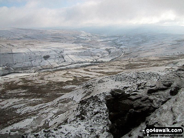
Little Fell (Lunds Fell) (Mallerstang) and Mallerstang Common from Wild Boar Fell in the snow
Nine Standards Rigg and upper Mallerstang Common from
Wild Boar Fell in the snow

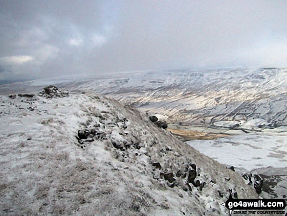
Little Fell (Lunds Fell) (Mallerstang) and Mallerstang Common from the lower slopes of Wild Boar Fell in the snow


The Howgills (left) and Wild Boar Fell (right) from Swarth Fell in the snow
. . . see all 17 walk photographs & pictures of views from, on, or of, Wild Boar Fell
Send us your photographs and pictures on, of, or from Wild Boar Fell
If you would like to add your walk photographs and pictures to this page, please send them as email attachments (configured for any computer) along with your name to:
and we shall do our best to publish them.
(Guide Resolution = 300dpi. At least = 660pixels (wide) x 440 pixels (high).)

You can also submit photos via our Facebook Page.
NB. Please indicate where each photo was taken and whether you wish us to credit your photos with a Username or your First Name/Last Name.


