
![]()
Nateby Common (Tailbridge Hill)
547m (1795ft)
The North Pennines, Cumbria, England

Not familiar with this top?
You can walk/hike to the top of Nateby Common (Tailbridge Hill) by using any of these 4 easy‑to‑follow route maps:
Walk c381 Nine Standards Rigg from Tailbridge Neck
Nine Standards Rigg - the easy way!
   |
|---|
Vital Statistics:
| Length: | 7.75ml (12km) |
|---|---|
| Ascent: | 1,083ft (330m) |
| Time: | 4 hrs |
| Grade: |  (Moderate) (Moderate) |

Route Summary:
B6270 - Tailbridge Neck - Nateby Common (Tailbridge Hill) - Dukerdale Pots - Tollinson Gill - Rollinson Haggs - Boston Gill Head - Nine Standards Rigg - White Mossy Hill - Birk Dale - Birkdale Cross - Birkdale Common - Uldale Beck - Lamps Moss - Tailbridge Neck.
Walk c404 Nine Standards Rigg and Whitsundale Beck from Tailbridge Neck
In the footsteps of Wainwright
|
|---|
Vital Statistics:
| Length: | 9.75ml (15.5km) |
|---|---|
| Ascent: | 1,467ft (447m) |
| Time: | 5 hrs |
| Grade: |  (Moderate) (Moderate) |

Route Summary:
B6270 - Tailbridge Neck - Nateby Common (Tailbridge Hill) - Dukerdale Pots - Tollinson Gill - Rollinson Haggs - Boston Gill Head - Nine Standards Rigg - Whitsundale Beck - Ney Gill - Birk Dale - Birkdale Cross - Birkdale Common - Uldale Beck - Lamps Moss - Tailbridge Ne.
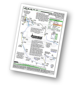
Walk c375 Nine Standards Rigg via The Coast to Coast walk from Kirkby Stephen
In the footsteps of Wainwright
|
|---|
Vital Statistics:
| Length: | 12.5ml (20km) |
|---|---|
| Ascent: | 2,127ft (648m) |
| Time: | 6.75hrs |
| Grade: |  (Moderate) (Moderate) |
Route Summary:
Kirkby Stephen - Market Square - Frank's Bridge - Hartley - Fell House - Hartley Fell - Faraday Gill - Nine Standards Rigg - White Mossy Hill - Coldbergh Scar - Dukerdale Head - Dukerdale Pots - Rigg Beck - Nateby Common (Tailbridge Hill) - B6270 - Tailbridge Neck - Green Hill - Stank Hill - Great Bell (long Crag) - Kitchen Gill - B6259 - Nateby - The River Eden - Kirkby Stephen
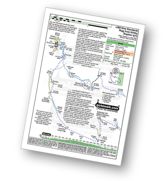
Walk c368 Nine Standards Rigg from Kirkby Stephen
The route Wainwright should have taken
|
|---|
Vital Statistics:
| Length: | 13.75ml (22km) |
|---|---|
| Ascent: | 2,507ft (764m) |
| Time: | 7½ hrs |
| Grade: |  (Hard) (Hard) |
Route Summary:
Kirkby Stephen - Market Square - Frank's Bridge - The River Eden - Ladthwaite Beck - Ewbank Scar - Birkett Hill - Ladthwaite Farm - Faraday Gill - Nine Standards Rigg - White Mossy Hill - Coldbergh Scar - Dukerdale Head - Dukerdale Pots - Rigg Beck - Nateby Common (Tailbridge Hill) - Green Hill - Stank Hill - Great Bell (Long Crag) - Kitchen Gill - B6259 - Nateby - The River Eden - Kirkby Stephen
See Nateby Common (Tailbridge Hill) and the surrounding tops on our free-to-access 'Google Style' Peak Bagging Map:
The North Pennines
Less data - quicker to download
See Nateby Common (Tailbridge Hill) and the surrounding tops on our unique, downloadable, PDF Peak Bagging Map:

NB: Whether you print off a copy or download it to your phone, this PDF Peak Baggers' Map might prove incredibly useful when your are up there on the tops and you cannot get a phone signal.
You can find Nateby Common (Tailbridge Hill) & all the walks that climb it on these unique free-to-access Interactive Walk Planning Maps:
1:25,000 scale OS Explorer Map (orange/yellow covers):
1:50,000 scale OS Landranger Maps (pink/magenta covers):
 Fellow go4awalkers who have already walked, climbed, scaled, summited, hiked & bagged Nateby Common (Tailbridge Hill)
Tony Rogerson walked up Nateby Common (Tailbridge Hill) on February 5th, 2017 [from/via/route] Stenkrith Bridge Nateby Tailbridge Neck Natebt Common Dukerdale Pots Jack Standards White Mossy Hill Nine Standards Rigg Hartley Fell Dismantled Railway [with] Caz Floss [weather] High cloud some sunny spells
David Congreave climbed it on September 24th, 2016 [from/via/route] Tailbridge Neck [with] Lydia
Darren Mortimer bagged it on March 15th, 2014 [from/via/route] Kirkby Stephen [with] Dermot Palmer & Graham Panton [weather] Overcast & windy
Patrick Rogozinski and Mark Davidson have both walked, climbed & bagged Nateby Common (Tailbridge Hill).
To add (or remove) your name and experiences on this page - Log On and edit your Personal Mountain Bagging Record
Send us your photographs and pictures on, of, or from Nateby Common (Tailbridge Hill)
If you would like to add your walk photographs and pictures to this page, please send them as email attachments (configured for any computer) along with your name to:
and we shall do our best to publish them.
(Guide Resolution = 300dpi. At least = 660pixels (wide) x 440 pixels (high).)

You can also submit photos via our Facebook Page.
NB. Please indicate where each photo was taken and whether you wish us to credit your photos with a Username or your First Name/Last Name.


