
![]()
Yarlside
639m (2097ft)
The Howgill Fells, The Yorkshire Dales, Cumbria, England
Not familiar with this top?
You can walk/hike to the top of Yarlside by using any of these 3 easy‑to‑follow route maps:
Walk c336 Calders, The Calf and Yarlside via Cautley Spout from The Cross Keys
A stunning waterfall - can be difficult in mist
   |
|---|
Vital Statistics:
| Length: | 6.5ml (10.5km) |
|---|---|
| Ascent: | 2,612ft (796m) |
| Time: | 5 hrs |
| Grade: |  (Moderate) (Moderate) |

Route Summary:
The Cross Keys - River Rawthey - Cautley Holme Beck - Cautley Spout - Cautley Crag - Great Dummacks - Little Dummacks - Calders - Bram Rigg Top - The Calf - Bowderdale Beck - Bowderdale Head - Yarlside - Ben End - The Cross Keys
Walk c330 Yarlside, Randygill Top, The Calf and Calders from The Cross Keys
The fabulous Howgills
|
|---|
Vital Statistics:
| Length: | 8ml (12.5km) |
|---|---|
| Ascent: | 3,485ft (1,062m) |
| Time: | 6½ hrs |
| Grade: |  (Hard) (Hard) |

Route Summary:
The Cross Keys - River Rawthey - Ben End - Yarlside - Kensgriff - Randygill Top - Bowderdale Beck - The Calf - Bram Rigg Top - Calders - Great Dummacks - Cautley Crag - Croonthard Brow - Cautley Holme Beck - River Rawthey - The Cross Keys
Walk c347 The Howgill Fells 2000ft'ers
All the Howgills 2000ft'ers - in the easiest order
|
|---|
Vital Statistics:
| Length: | 11.5ml (18.5km) |
|---|---|
| Ascent: | 4,411ft (1,344m) |
| Time: | 8.75hrs |
| Grade: |  (Hard) (Hard) |
Route Summary:
The Cross Keys - River Rawthey - Ben End - Yarlside - Kensgriff - Randygill Top - Bowderdale Beck - The Calf - Bush Howe - Fell Head (Howgills) - The Calf - Bram Rigg Top - Calders - Cautley Crag - Croonthard Brow - Cautley Holme Beck - River Rawthey - The Cross Keys
See Yarlside and the surrounding tops on our free-to-access 'Google Style' Peak Bagging Maps:
The Howgill Fells Area of The Yorkshire Dales National Park
Less data - quicker to download
The Whole of The Yorkshire Dales National Park
More data - might take a little longer to download
See Yarlside and the surrounding tops on our unique, downloadable, PDF Peak Bagging Map:

NB: Whether you print off a copy or download it to your phone, this PDF Peak Baggers' Map might prove incredibly useful when your are up there on the tops and you cannot get a phone signal.
You can find Yarlside & all the walks that climb it on these unique free-to-access Interactive Walk Planning Maps:
1:25,000 scale OS Explorer Map (orange/yellow covers):
1:50,000 scale OS Landranger Map (pink/magenta covers):
 Fellow go4awalkers who have already walked, climbed, scaled, summited, hiked & bagged Yarlside
Caroline Winter walked up Yarlside on May 31st, 2021 [from/via/route] Cross keys pub, Ben End, Yarlside, Kensgriff, Randy Gill Top, Bowderdale Beck, The Calf, White Fell Head, Calders, Great Dummacks, Pickering Gill [with] Becky [weather] Excellent views. Warm & sunny. Windy on tops - Long day with lots of ups & downs
Mark Davidson climbed it on June 8th, 2006 [from/via/route] Walk c347 The Howgill Fells 2000ft'ers [with] MK [weather] Sunny & dry - gorgeous!
Margaret Richards bagged it on October 18th, 2018 [from/via/route] c330 Yarlside, Randygill Top, The Calf & Calders from The Cross Keys [with] Don [weather] Sunny, beautiful calm day - Very hard, steep slopes
Kevin Foster hiked Yarlside on October 26th, 2017 [from/via/route] Randygill Top (via Kensgriff). [with] Henry. [weather] Cloudy but tops clear (just), Sunny later. - This walk was an adaptation of a walk I found in Wainwright's 'Walks on the Howgill Fells'. I extended the approach bit up the remote valley of Westerdale to include Randygill Top. The return over Kensgriff & Yarlside involved some calf busting descents & then reascents which are typical of the hills in this area.
David Congreave summited on March 17th, 2018 [from/via/route] The Cross Keys [with] Jonah [weather] Snowy peaks but weather fairly mild.
To add (or remove) your name and experiences on this page - Log On and edit your Personal Mountain Bagging Record
. . . [see more walk reports]
More Photographs & Pictures of views from, on, or of, Yarlside
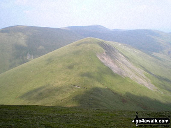


Cautley Crag, Cautley Spout, Yarlside, Cautley Holme Beck, and Cross Keys from Great Dummacks


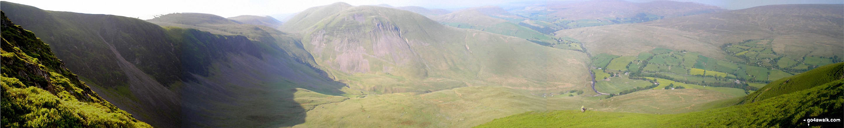
Cautley Crag, Cautley Spout, Bowderdale Head and Yarlside from Great Dummacks


. . . see all 22 walk photographs & pictures of views from, on, or of, Yarlside
Send us your photographs and pictures on, of, or from Yarlside
If you would like to add your walk photographs and pictures to this page, please send them as email attachments (configured for any computer) along with your name to:
and we shall do our best to publish them.
(Guide Resolution = 300dpi. At least = 660pixels (wide) x 440 pixels (high).)

You can also submit photos via our Facebook Page.
NB. Please indicate where each photo was taken and whether you wish us to credit your photos with a Username or your First Name/Last Name.


