Four easy to follow circular walk route maps from the village of Braithwaite in the The Lake District National Park, Cumbria, England
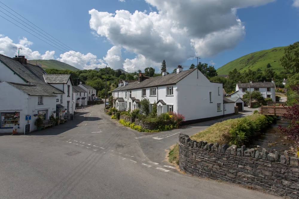 Braithwaite Village
Photo: Visit Keswick
Braithwaite is a charming village nestling in the heart of the English Lake District, offering stunning scenery and a peaceful atmosphere. Located just west of Keswick, the village is surrounded by breathtaking mountains, lush valleys, and crystal-clear lakes.
Braithwaite is situated at the foot of Whinlatter Pass, between Derwentwater and Bassenthwaite Lake. It's about 2.5 miles from Keswick and can be reached by car via the A66 or bus on the X4 or X5.
Braithwaite makes a great base for exploring the northwestern Lake District with plenty of local walks to suit most tastes.
Walking the Wainwrights from Braithwaite
Walkers seeking to Walk the Wainwrights will find no shortage of opportunities to add to their hill bagging tick lists with 10 Wainwrights accessible by foot direct from Braithwaite itself. These are:-
- Grasmoor (No. 20);
- Crag Hill (Eel Crag) (No. 24);
- Grisedale Pike (No. 40);
- Sail (Derwent Fells) (No. 50);
- Wandope (No. 51);
- Hopegill Head (No. 52);
- Scar Crags (No. 101);
- Causey Pike (No. 120);
- Outerside (No. 142);
- Barrow (Newlands) (No. 187);
All 10 of these Wainwrights can be climbed using Walk c310 The Coledale Horseshoe from Braithwaite though at 12 miles long and some 5,261ft of ascent it is not for the faint-hearted.
Nearby is the beautiful Newlands Valley and Whinlatter Forest for those who prefer a gentler kind of walk.
Braithwaite has a rich history, with evidence of Roman occupation and medieval settlements. Nowadays, Braithwaite has a village shop (which began trading in 1830), pubs (Royal Oak & Coledale Inn), and a community centre, providing essential services for residents and visitors.
Braithwaite Village Camping & Caravanning Club Site is located in the village and has 150 grass or hardstanding pitches. The site is suitable for tents, caravans, and motorhomes, and has a children's play area, bike services area, and public transport within 1 mile.
Nearby Keswick, which can be reached by foot on a path that avoids the busy road, offers an even wider range of shops, restaurants, and cultural attractions.
4 easy to follow walks from Braithwaite
   |
Vital Statistics:
| Length: | 7.25 miles (11.5 km) |
| Ascent: | 3,013ft (918m) |
| Time: | 5.75hrs |
| Grade: |  |
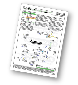
Route Summary:
Braithwaite - Barrow (Newlands) - Stile End - Low Moss - Outerside - High Moss - Scar Crags - Causey Pike - Sleet Hause - Rowling End - Stoneycroft - Braithwaite
|
Vital Statistics:
| Length: | 8.5 miles (13.5 km) |
| Ascent: | 3,840ft (1,170m) |
| Time: | 7 hrs |
| Grade: |  |

Route Summary:
Braithwaite - Sleet How - Grisedale Pike - Hobcarton Crag - Hopegill Head - Sand Hill - Coldale Hause - Eel Crag - Crag Hill (Eel Crag) - Sail (Derwent Fells) - Long Comb - High Moss - Low Moss - Barrow Door - Braithwaite
|
Vital Statistics:
| Length: | 10 miles (16 km) |
| Ascent: | 4,641ft (1,414m) |
| Time: | 8½ hrs |
| Grade: |  |
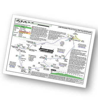
Route Summary:
Braithwaite - Sleet How - Grisedale Pike - Hobcarton Crag - Hopegill Head - Sand Hill - Coledale Hause - Crag Hill (Eel Crag) - Sail (Derwent Fells) - Scar Crags - Causey Pike - Outerside - Stile End - Barrow (Newlands) - Braithwaite
|
Vital Statistics:
| Length: | 12 miles (19 km) |
| Ascent: | 5,261ft (1,603m) |
| Time: | 9.75hrs |
| Grade: |  |

Route Summary:
Braithwaite - Sleet How - Grisedale Pike - Hobcarton Crag - Hopegill Head - Sand Hill - Coledale Hause - Grasmoor - Wandope - Crag Hill (Eel Crag) - Sail (Derwent Fells) - Scar Crags - Causey Pike - Outerside - Stile End - Barrow (Newlands) - Braithwaite


