Fourteen easy to follow circular walk route maps from the tiny village of Stonethwaite, Rosthwaite & Seatoller in the The Lake District National Park, Cumbria, England
   |
Vital Statistics:
| Length: | 8.25 miles (13 km) |
| Ascent: | 1,031ft (314m) |
| Time: | 4 hrs |
| Grade: |  |
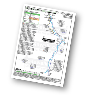
Route Summary:
Rosthwaite - Wainwright's Coast to Coast Walk - Stonethwaite - Stonethwaite Beck - Galleny Force - Langstrath Beck - The Cumbria Way - Greenup Gill - Stonethwaite - Rosthwaite
|
Vital Statistics:
| Length: | 5.5 miles (9 km) |
| Ascent: | 1,384ft (422m) |
| Time: | 3½ hrs |
| Grade: | |
Route Summary:
Seatoller - The Allerdale Ramble - Longthwaite - Rosthwaite - New Bridge - The River Derwent - The Cumbria Way - Castle Crag - Seatoller
|
Vital Statistics:
| Length: | 9.75 miles (15.5 km) |
| Ascent: | 886ft (270m) |
| Time: | 4.25hrs |
| Grade: | |
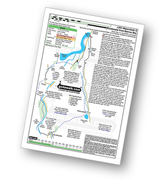
Route Summary:
Barrow Bay - Derwent Water - Ashness Bridge - Surprise View - Watendlath - Bracken Platt - Puddingstone Bank - The Cumbria Way - Rosthwaite - River Derwent - High Hows Wood - Low Hows Wood - Broadslack Gill - Hollows Farm - Borrowdale Gates - Ellers Beck Lodore Falls - Barrow Bay - Derwent Water
|
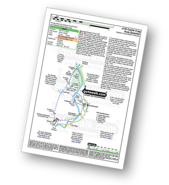
Vital Statistics:
| Length: | 6 miles (9.5 km) |
| Ascent: | 1,861ft (567m) |
| Time: | 4½ hrs |
| Grade: |  |

Route Summary:
Rosthwaite - The Cumbria Way - Lingy End - Willygrass Gill - Dock Tarn - Great Crag - Puddingstone Bank - Jopplety How - Joppletyhow Moss - Grange Fell (Brund Fell) - King's How - Rosthwaite
|
Vital Statistics:
| Length: | 9 miles (14.5 km) |
| Ascent: | 2,780ft (847m) |
| Time: | 6 hrs |
| Grade: |  |
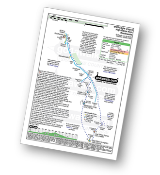
Route Summary:
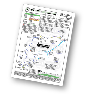
Rosthwaite - Stonethwaite - Wainwright's Coast to Coast Walk - Stonethwaite Beck - Galleny Force - The Cumbria Way - Langstrath Beck - Eagle Crag - Sergeant's Crag - High Raise (Langdale) - Low White Stones - Greenup Edge - Lining Crag - Greenup Gill - Stonethwaite Beck - Stonethwaite - Rosthwaite
|
Vital Statistics:
| Length: | 8.25 miles (13 km) |
| Ascent: | 3,016ft (919m) |
| Time: | 6 hrs |
| Grade: | |
Route Summary:
Seatoller - Seathwaite (Borrowdale) - Sourmilk Gill (Borrowdale) - Gillercomb - Blackmoor Pols - Mitchell Cove - Green Gable - Windy Gap - Great Gable - Westmorland Cairn - Beck Head - Beckhead Tarn - Moses' Trod - Honister Pass - Honister Hause - Wainwright's Coast to Coast Walk - Seatoller
|
Vital Statistics:
| Length: | 7.75 miles (12.5 km) |
| Ascent: | 2,419ft (737m) |
| Time: | 5.25hrs |
| Grade: | |

Route Summary:
Stonethwaite - Stonethwaite Bridge - Stonethwaite Beck - The Cumbria Way - Wainwright's Coast to Coast Walk - Galleny Force - Greenup Gill - Lining Crag - Greenup Edge - Ullscarf - High Saddle (Coldbarrow Fell) - Low Saddle (Coldbarrow Fell) - Lord's How - Green Combe - Dock Tarn - Great Crag - Willygrass Gill - Stonethwaite
|
Vital Statistics:
| Length: | 10.5 miles (17 km) |
| Ascent: | 3,407ft (1,038m) |
| Time: | 7.25hrs |
| Grade: |  |

Route Summary:
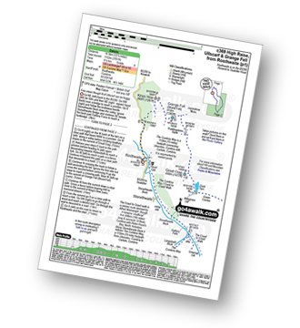
Seatoller - Big Stanger Gill - Hanging Haystack Crag - Alisongrass Crag - Rosthwaite Fell (Bessyboot) - Tarn At Leaves - Rosthwaite Cam (Rosthwaite Fell) - Dovenest Top - Combe Door Top - Combe Head - Glaramara - Looking Steads (Glaramara) - Red Beck Top - High House Tarn Top - Allen Crags - Sprinking Tarn - Seathwaite Fell (South Top) - Seathwaite Fell - Grains Gill - The Allerdale Ramble - Stockley Bridge - Seathwaite (Borrowdale) - Thornythwaite Farm - Strands Bridge - The River Derwent - Seatoller
|
Vital Statistics:
| Length: | 11.25 miles (18 km) |
| Ascent: | 3,371ft (1,027m) |
| Time: | 7½ hrs |
| Grade: | |

Route Summary:
Rosthwaite - Stonethwaite - Wainwright's Coast to Coast Walk - Stonethwaite Beck - Galleny Force - The Cumbria Way - Langstrath Beck - Eagle Crag - Sergeant's Crag - High Raise (Langdale) - Low White Stones - Greenup Edge - Ullscarf - High Saddle (Coldbarrow Fell) - Low Saddle (Coldbarrow Fell) - Lord's How - Dock Tarn - Willygrass Gill - Great Crag - Rosthwaite
|
Vital Statistics:
| Length: | 9.75 miles (15.5 km) |
| Ascent: | 3,046ft (928m) |
| Time: | 6½ hrs |
| Grade: | |

Route Summary:
Seatoller - Strands Bridge - Borrowdale - The Combe - Thornythwaite Fell - Comb Head - Glaramara - Looking Steads (Glaramara) - Red Beck - Red Beck Top - Allen Gill - High House Tarn - High House Tarn Top - Allen Crags - Esk Hause - Ruddy Gill - Sprinkling Tarn - Sty Head - Sty Head Tarn - Sty Head Gill - Stockley Bridge - Grains Gill - Seathwaite (Borrowdale) - The Allerdale Ramble - Seatoller
|
Vital Statistics:
| Length: | 10.5 miles (17 km) |
| Ascent: | 3,384ft (1,031m) |
| Time: | 7.25hrs |
| Grade: | |

Route Summary:
Stonethwaite - Big Stanger Gill - Hanging Haystack Crag - Alisongrass Crag - Rosthwaite Fell (Bessyboot) - Tarn At Leaves - Rosthwaite Cam (Rosthwaite Fell) - Dovenest Top - Combe Door Top - Combe Head - Glaramara - Looking Steads (Glaramara) - Red Beck Top - High House Tarn Top - Allen Crags - Esk Hause - Allencrags Gill - Langstrath - Stonethwaite
|
Vital Statistics:
| Length: | 10.5 miles (17 km) |
| Ascent: | 4,693ft (1,430m) |
| Time: | 8½ hrs |
| Grade: |  |

Route Summary:
Seatoller - Strands Bridge - Borrowdale - The Combe - Thornythwaite Fell - Comb Head - Glaramara - Looking Steads (Glaramara) - Red Beck - Red Beck Top - Allen Gill - High House Tarn - High House Tarn Top - Allen Crags - Esk Hause - Ruddy Gill - Sprinkling Tarn - Sty Head - Great Gable - Westmorland Cairn - Windy Gap - Green Gable - Gillercomb Head - Brandreth - Grey Knotts - Honister Hause - Honister Pass - Wainwright's Coast to Coast Walk - Seatoller
|
Vital Statistics:
| Length: | 12 miles (19 km) |
| Ascent: | 3,502ft (1,067m) |
| Time: | 7.75hrs |
| Grade: | |

Route Summary:
Stonethwaite - Wainwright's Coast to Coast Walk - Stonethwaite Beck - Galleny Force - The Cumbria Way - Langstrath Beck - Stake Pass - Pike of Stickle (Pike O' Stickle) - Harrison Stickle - Thunacar Knott - High Raise (Langdale) - Low White Stones - Greenup Edge - Ullscarf - Low Saddle (Coldbarrow Fell) - Willygrass Gill - Dock Tarn.
|
Vital Statistics:
| Length: | 12.25 miles (19.5 km) |
| Ascent: | 3,781ft (1,152m) |
| Time: | 8½ hrs |
| Grade: | |
Route Summary:
Rosthwaite - The Cumbria Way - Stonethwaite - Wainwright's Coast to Coast Walk - Stonethwaite Beck - Galleny Force - The Cumbria Way - Langstrath Beck - Eagle Crag - Sergeant's Crag - High Raise (Langdale) - Low White Stones - Greenup Edge - Ullscarf - Low Saddle (Coldbarrow Fell) - Lord's How - Dock Tarn - Great Crag - Puddingstone Bank - Jopplety How - Joppletyhow Moss - Grange Fell (Brund Fell) - King's How - Rosthwaite


