29 walks in The Far Eastern Fells area of The Lake District
Twenty-nine easy-to-follow, hand-crafted walks including routes from Ambleside, Brothers Water, Christy Bridge, Glenridding, Howtown, Mardale Head, Patterdale, Stockdale & Troutbeck that climb the Angletarn Pikes, High Street (the highest point), Place Fell, Steel Knotts (Pikeawassa), Yoke, Ill Bell, Froswick, Thornthwaite Crag, Stony Cove Pike (Caudale Moor) & Wansfell Pike amongst many others. More details about each walk can be found below the map.
The Far Eastern Fells area of The Lake District National Park is enclosed by:
- Ullswater to the North West
- The Kirkstone Pass and Ambleside to the West
- an imaginary line from Ambleside through Troutbeck, Kentmere and Sadgill to the Eastern tip of Haweswater Reservoir and then North to Pooley Bridge
Interactive Map of Walks in The Far Eastern Fells area of The Lake District
![]() How to Load this interactive map: Due to usage restrictions, you must be Registered and Logged-On to go4awalk.com to view and use the interactive Google Map below. You do not need to purchase any credits, but you must be Registered and Logged-On.
How to Load this interactive map: Due to usage restrictions, you must be Registered and Logged-On to go4awalk.com to view and use the interactive Google Map below. You do not need to purchase any credits, but you must be Registered and Logged-On.

You can use these checkboxes to show only the grades of walk you are interested in:-
Twenty-nine easy-to-follow, circular, walk route maps in The Far Eastern Fells area of The Lake District in Walk Length Order (Shortest to Longest)
See this list of walks, routes & maps in:
Grade Order | Length Order | Time Order | Walk Number or Start Location Order
NB. To reverse (toggle) this order, click Length Order again
Scroll down the list of walks below & click on each walk title (in blue) to locate it on the map above.
   |
Vital Statistics:
| Length: | 4.75 miles (7.5 km) |
| Ascent: | 1,292 ft (394 m) |
| Time: | 3 hrs |
| Grade: |  |
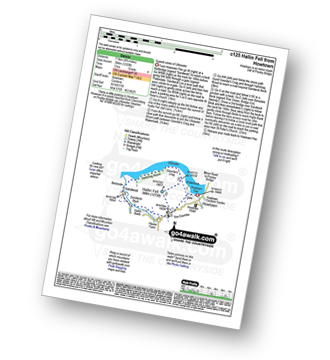
Route Summary:
Howtown - St Peter's Church - Hallin Fell - Geordie's Crag - Hallinhag Wood - Sandwick - Sandwick Beck - Howtown
|
Vital Statistics:
| Length: | 5 miles (8 km) |
| Ascent: | 912 ft (278 m) |
| Time: | 2.75 hrs |
| Grade: |  |
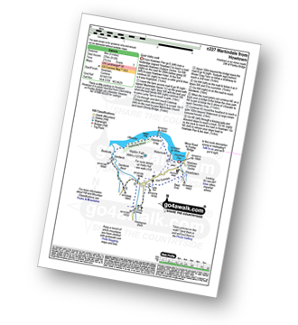
Route Summary:
Howtown - The Coombs - St Peter's Church - Lanty Tarn - Martindale - Christy Bridge - Howegrain Beck - Sandwick Beck - Sandwick - Hallinhag Wood - Geordie's Crag - Waternook - Howtown
|
Vital Statistics:
| Length: | 5.5 miles (8.5 km) |
| Ascent: | 1,582 ft (482 m) |
| Time: | 3.75 hrs |
| Grade: | |
Route Summary:
Troutbeck Bridge - Garburn Road - Backstone Barrow - Sour Howes - Sallows - Garburn Pass - Troutbeck - Troutbeck Bridge
|
Vital Statistics:
| Length: | 5.75 miles (9 km) |
| Ascent: | 1,260 ft (384 m) |
| Time: | 3½ hrs |
| Grade: | |
Route Summary:
Kentmere - Cornclose Lane (track) - Rasp Howe - Skeggles Water - Cocklaw Fell - Green Quarter Fell - Hollow Moor (Green Quarter) - Hollow Moor (North East Top) - Kentmere
|
Vital Statistics:
| Length: | 6 miles (9.5 km) |
| Ascent: | 2,192 ft (668 m) |
| Time: | 5 hrs |
| Grade: |  |
Route Summary:
Ambleside - Stockghyll Force - Wansfell Pike - Baystones (Wansfell) - The Hundreds - Nanny Lane - Troutbeck - Robin Lane - High Skelghyll Farm - Skelghyll Wood - Jenkin Crag - Ambleside
|
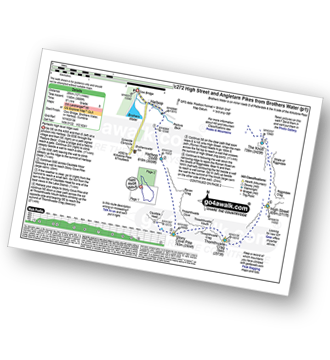
Vital Statistics:
| Length: | 6 miles (9.5 km) |
| Ascent: | 2,202 ft (671 m) |
| Time: | 4½ hrs |
| Grade: | |

Route Summary:
Mardale Head - Haweswater Reservoir - The Rigg - Swine Crag (Riggindale) - Heron Crag (Riggindale) - Eagle Crag (Riggindale) - Rough Crag (Riggindale) - Caspel Gate - Riggindale Crag - Long Stile - High Street - Rough Crag (Riggindale) - Eagle Crag (Riggindale) - Heron Crag (Riggindale) - Swine Crag (Riggindale) - Dudderwick - The Rigg - Mardale Head
|
Vital Statistics:
| Length: | 6.5 miles (10.5 km) |
| Ascent: | 643 ft (196 m) |
| Time: | 3 hrs |
| Grade: | |
Route Summary:
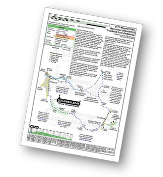
Patterdale - Noran Bank Farm - Greenbank Farm - Lane Head - Deepdale Bridge - Low Wood - Cow Bridge - Brothers Water - Hartsop Hall - Sykeside - Brothers Water - Hartsop - Eden Beck - Hartsop Fold - Angletarn Beck - Beckstones - Crookabeck - Dubhow - Rooking - Patterdale
|
Vital Statistics:
| Length: | 7.25 miles (11.5 km) |
| Ascent: | 2,745 ft (837 m) |
| Time: | 5½ hrs |
| Grade: |  |

Route Summary:
Mardale Head - Haweswater Reservoir - The Rigg - Dudderwick - Swine Crag (Riggindale) - Heron Crag (Riggindale) - Rough Crag (Riggindale) - Caspel Gate - Riggindale Crag - Long Stile - High Street - Mardale Ill Bell - Nan Bield Pass - Harter Fell (Mardale) - Adam Seat - Gatescarth Pass - Mardale Head
|
Vital Statistics:
| Length: | 7.5 miles (12 km) |
| Ascent: | 2,283 ft (696 m) |
| Time: | 5.25 hrs |
| Grade: |  |

Route Summary:
Howtown - Steel Knotts (Pikeawassa) - Brownthwaite Crag - Keasgill Head - Wether Hill (South Top) - Wether Hill - Loadpot Hill - Bonscale Pike - Bonscale Tower - Swarthbeck Gill - Howtown
|
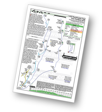
Vital Statistics:
| Length: | 7.5 miles (12 km) |
| Ascent: | 3,131 ft (954 m) |
| Time: | 5.75 hrs |
| Grade: | |

Route Summary:
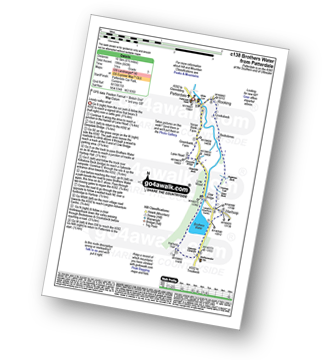
Cow Bridge - Brothers Water - Hartsop - Hartsop Dodd - Caudale Moor - Caudale Head - Stony Cove Pike (Caudale Moor) - Threshthwaite Mouth - Thornthwaite Crag - Gray Crag (Hayeswater) - Hayeswater Gill - Hartsop - Cow Bridge
|
Vital Statistics:
| Length: | 7.5 miles (12 km) |
| Ascent: | 1,216 ft (462 m) |
| Time: | 4.25 hrs |
| Grade: | |

Route Summary:
Ullthwaite Bridge - Croft Head - Meadowplatts Plantation - Capple Howe - Sour Howes - Sallows - Garburn Pass - Crabtree Brow - Kentmere - kentmere Hall - Hall Wood - Kentmere Plantation - Sawmill Cottage - Kentmere - Ullthwaite Bridge
|
Vital Statistics:
| Length: | 8.25 miles (13 km) |
| Ascent: | 1,421 ft (433 m) |
| Time: | 4½ hrs |
| Grade: | |

Route Summary:
Troutbeck Bridge - Troutbeck - Limefitt Holiday Park - Long Green Head - Ing Bridge - Troutbeck Park - Park Fell Head - Trout Beck - Troutbeck Tongue - Hagg Gill - Lowther Brow - Long Green Head - Limefitt Holiday Park - Troutbeck - Troutbeck Bridge
|
Vital Statistics:
| Length: | 8.5 miles (13.5 km) |
| Ascent: | 2,552 ft (778 m) |
| Time: | 6 hrs |
| Grade: | |
Route Summary:
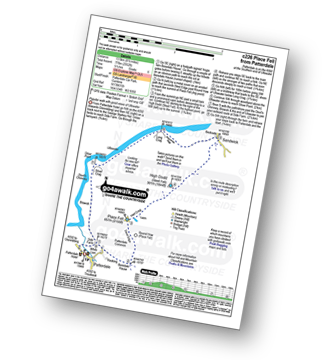
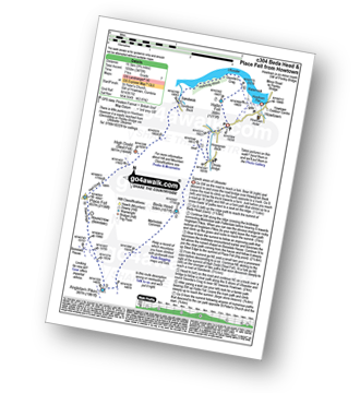
Patterdale - Rooking - Boredale Hause - Place Fell - High Dodd (Sleet Fell) - Martindale - Sandwick - Long Crag (Ullswater) - Silver Point - Ullswater - Blowick - Rooking - Side Farm - Patterdale
|
Vital Statistics:
| Length: | 8.5 miles (13.5 km) |
| Ascent: | 1,994 ft (608 m) |
| Time: | 5 hrs |
| Grade: | |

Route Summary:
Howtown - Lock Bank - White Knott - Barton Fell - Whinny Crag - Arthur's Pike - Loadpot Hill - Bonscale Pike - Swarthbeck Gill - Howtown
|
Vital Statistics:
| Length: | 9 miles (14.5 km) |
| Ascent: | 2,619 ft (798 m) |
| Time: | 6 hrs |
| Grade: | |
Route Summary:
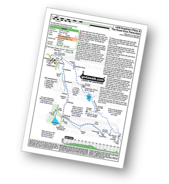
Patterdale - Side Farm - Boredale Hause - Angletarn Pikes - Angle Tarn (Martindale) - Satura Crag - Brock Crags - Satura Crag - The Knott - Hayeswater Reservoir - Hayeswater Gill - Hartsop - Dubhow - Beckstones - Crookabeck - Rooking - Side Farm - Patterdale
|
Vital Statistics:
| Length: | 9.75 miles (15.5 km) |
| Ascent: | 3,470 ft (1,058 m) |
| Time: | 7 hrs |
| Grade: | |
Route Summary:
St Peter's Church (Martindale) - Howtown - Howegrain Beck - Christy Bridge - Beda Head (Beda Fell) - Martindale Common - Angletarn Pikes - Angle Tarn (Martindale) - Boredale Hause - Steel Edge - Place Fell - High Dodd (Sleet Fell) - Sandwick - Hallinhag Wood - Geordies Crag - Hallin Fell (Martindale) - Howtown
|
Vital Statistics:
| Length: | 10.5 miles (17 km) |
| Ascent: | 3,417 ft (1,041 m) |
| Time: | 7.25 hrs |
| Grade: | |

Route Summary:
Stockdale - Sadgill Bridge - Stockdale Beck - Great Howe - Grey Crag (Sleddale) - Tarn Crag (Sleddale) - Sleddale Fell - Selside Brow - Branstree (Artlecrag Pike) - Gatescarth Pass - Adam Seat - Harter Fell (Mardale) - Kentmere Pike - Goat Scar - Shipman Knotts - Wray Crag - Stockdale
|
Vital Statistics:
| Length: | 11 miles (17.5 km) |
| Ascent: | 3,410 ft (1,039 m) |
| Time: | 7½ hrs |
| Grade: | |

Route Summary:
Troutbeck Bridge - Garburn Road - Backstone Barrow - Sour Howes - Sallows - Garburn Pass - Yoke - Ill Bell - Froswick - Wanfer Crag - Hagg Gill - Trout Beck - Troutbeck Tongue - Lowther Brow - Long Green Head - Limefitt Campsite - Troutbeck - Troutbeck Bridge
|
Vital Statistics:
| Length: | 11.25 miles (18 km) |
| Ascent: | 2,736 ft (834 m) |
| Time: | 6.75 hrs |
| Grade: | |

Route Summary:
St Peter's Church (Martindale) - Howtown - Swarthbeck Gill - White Knott - Barton Fell - Whinny Crag - Arthur's Pike - Swarth Beck - Bonscale Tower - Bonscale Pike - Loadpot Hill - Wether Hill - Wether Hill (South Top) - Keasgill Head - Steel Knotts (Pikeawassa) - Steel End - St Peter's Church (Martindale) - Howtown
|
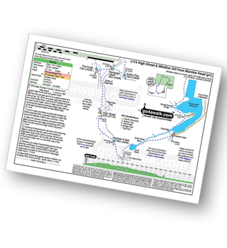
Vital Statistics:
| Length: | 11.25 miles (18 km) |
| Ascent: | 3,843 ft (1,171 m) |
| Time: | 8 hrs |
| Grade: |  |

Route Summary:
Cow Bridge - Brothers Water - Hartsop - Hartsop Dodd - Caudale Moor - Stony Cove Pike (Caudale Moor) - Caudale Head - Stony Cove Pike - Threshthwaite Mouth - Thornthwaite Crag - High Street - Straits of Riggindale - Rampsgill Head - Kidsty Pike - High Raise (Mardale) - The Knott - Hayeswater Reservoir - Hayeswater Gill - Hartsop - Cow Bridge - Brothers Water.
|
Vital Statistics:
| Length: | 11.25 miles (18 km) |
| Ascent: | 3,436 ft (1,047 m) |
| Time: | 7½ hrs |
| Grade: | |

Route Summary:
Mardale Head - Haweswater Reservoir - Rowantreethwaite Beck - Old Corpse Road - Selside Pike - Branstree (North East Top) - Branstree (Artlecrag Pike) - Gatescarth Pass - Adam Seat - Harter Fell (Mardale) - Nan Bield Pass - Mardale Ill Bell - High Street - Riggindale Crag - Caspel Gate - Rough Crag (Riggindale) - Eagle Crag (Riggindale) - Heron Crag (Riggindale) - Swine Crag (Riggindale) - Dudderwick - The Rigg - Mardale Head
|
Vital Statistics:
| Length: | 11.5 miles (18.5 km) |
| Ascent: | 3,378 ft (1,030 m) |
| Time: | 7½ hrs |
| Grade: | |

Route Summary:
Kentmere - Garburn Pass - Yoke - Ill Bell - Froswick - Thornthwaite Crag - Mardale Ill Bell - Nan Bield Pass - Harter Fell (Mardale) - Kentmere Pike - Brookstones - Kentmere
|
Vital Statistics:
| Length: | 12.25 miles (19.5 km) |
| Ascent: | 4,194 ft (1,278 m) |
| Time: | 8.75 hrs |
| Grade: | |
Route Summary:
Troutbeck Bridge - Garburn Pass - Yoke - Ill Bell - Froswick - Thornthwaite Crag - Stony Cove Pike (Caudale Moor) - Doup Crag - Trout Beck - Troutbeck Tongue - Hagg Gill - Lowther Brow - Long Green Head - Limefitt Campsite - Troutbeck - Troutbeck Bridge
|
Vital Statistics:
| Length: | 12.5 miles (20 km) |
| Ascent: | 3,769 ft (1,149 m) |
| Time: | 8½ hrs |
| Grade: | |

Route Summary:
Christy Bridge - Martindale - Dale Head Farm - Heck Crag - Angle Tarn - Buck Crag - Brock Crags - Satura Crag - The Nab (Martindale) - Rest Dodd - The Knott - Rampsgill Head - Kidsty Pike - High Raise (Mardale) - Red Crag - Keasgill Head - Christy Bridge
|
Vital Statistics:
| Length: | 12.5 miles (20 km) |
| Ascent: | 3,814 ft (1,162 m) |
| Time: | 8½ hrs |
| Grade: | |

Route Summary:
Mardale Head - Haweswater - Rowantreethwaite Beck - Old Corpse Road - Selside Pike - Branstree (North East Top) - Branstree (Artlecrag Pike) - Gatescarth Pass - Adam Seat - Harter Fell (Mardale) - Nan Bield Pass - Mardale Ill Bell - High Street - Riggindale - Rampsgill Head - Wainwright's Coast to Coast Walk - Kidsty Pike - Kidsty Howes - Bowderthaite Bridge - The Rigg - Mardale Head
|
Vital Statistics:
| Length: | 12.5 miles (20 km) |
| Ascent: | 3,889 ft (1,185 m) |
| Time: | 8½ hrs |
| Grade: | |
Route Summary:
Cow Bridge - Brothers Water - Hartsop - Hartsop Dodd - Stony Cove Pike - Caudale Head - Caudale Moor - Stony Cove Pike (Caudale Moor) - Threshthwaite Mouth - Thornthwaite Crag - High Street - Straits of Riggindale - The Knott - Angle Tarn (Martindale) - Angletarn Pikes - Boredale Hause - Patterdale
|
Vital Statistics:
| Length: | 14.5 miles (23 km) |
| Ascent: | 3,364 ft (1,025 m) |
| Time: | 8½ hrs |
| Grade: | |
Route Summary:
Mardale Head (Haweswater Reservoir) - Small Water - Nan Bield Pass - Mardale Ill Bell - High Street - Straits of Riggindale - The Knott - Rampsgill Head - Kidsty Pike - High Raise (Mardale) - Raven Howe - Red Crag - Keasgill Head - Wether Hill (South Top) - Wether Hill - Bampton Common - Low Kop - Measand Beck - Haweswater Reservoir - Wainwright's Coast to Coast Walk - Bowderthwaite Bridge - The Rigg - Mardale Head
|
Vital Statistics:
| Length: | 14.5 miles (23 km) |
| Ascent: | 4,555 ft (1,388 m) |
| Time: | 9.75 hrs |
| Grade: |  |

Route Summary:
St Peter's Church (Martindale) - Howtown - Steel Knotts (Pikeawassa) - Keasgill Head - High Raise (Mardale) - Kidsty Pike - Rampsgill Head - The Knott - Rest Dodd - The Nab - Satura Crag - Brock Crags - Angle Tarn (Martindale) - Angletarn Pikes - Bedafel Knott - Beda Head (Beda Fell) - Winter Crag - Christy Bridge - Howegrain Beck - Martindale - St Peter's Church (Martindale) - Howtown
|
Vital Statistics:
| Length: | 15.5 miles (25 km) |
| Ascent: | 4,293 ft (1,308 m) |
| Time: | 10 hrs |
| Grade: | |

Route Summary:
Patterdale - Rooking - Crookabeck - Beckstones - Dubhow - Hartsop - Hayswater Gill - Hayswater - The Knott - Brock Crags - Angle Tarn (Martindale) - Angletarn Pikes - Boredale Hause - Place Fell - High Dodd (Sleet Fell) - Sandwick - Long Crag - Silver Point - Ullswater - Blowick - Rooking - Side Farm - Patterdale
See this list of walks, routes & maps in:
Grade Order | Length Order | Time Order | Walk Number or Start Location Order
NB. To reverse (toggle) this order, click Length Order again


