UK Postcode CA14 - The 30 nearest easy-to-follow, circular walk route maps to you
The thirty nearest easy-to-follow, circular walk route maps to you in UK Postcode CA14 in Walk Grade Order
The UK cities, towns and villages in Cumbria, England that have CA14 in their UK Postcode include:
• Asby • Branthwaite • Bridgefoot • Camerton • Dean • Distington • Gilgarran • Great Clifton • High Harrington • Lamplugh • Little Clifton • Pica • Seaton • Ullock • Westfield • Workington •
Not familiar with the area around CA14?
See these 30 nearest walks to UK Postcode CA14 on a google map
   |
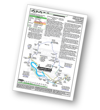
Vital Statistics:
| Length: | 6.25 miles (10 km) |
| Ascent: | 1,523ft (464m) |
| Time: | 3.75hrs |
| Grade: |  |
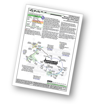
Route Summary:
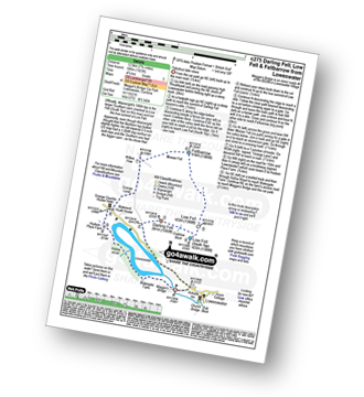
Wath Bridge - Cleator Moor - River Ehen - Ramsgill Wood - Old Wood - Black How - Wainwright's Coast to Coast Walk - Blackhow Wood - Weather Slacks - Dent (Long Barrow) - Uldale Plantation - Kirk Beck - Uldale - Nannycatch Gate - Flat Fell - Brown Bank - Wath Bridge
|
Vital Statistics:
| Length: | 4.5 miles (7 km) |
| Ascent: | 630ft (192m) |
| Time: | 2.25hrs |
| Grade: |  |
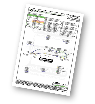
Route Summary:
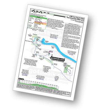
Cockermouth - Watch Hill (Cockermouth) - Hay - Setmurthy Plantation - Setmurthy Common (Watch Hill) - Peel Wood - Long Bottom - Greenlands - Cockermouth
|
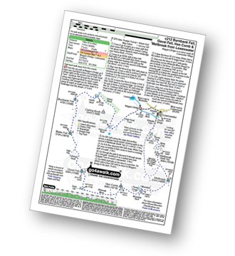
Vital Statistics:
| Length: | 8.5 miles (13.5 km) |
| Ascent: | 2,540ft (774m) |
| Time: | 6 hrs |
| Grade: |  |

Route Summary:
Maggie's Bridge (Loweswater) - Loweswater - High Nook Farm - Highnook Beck - Holme Wood - Holme Beck - Burnbank Fell - Sharp Knott - Blake Fell - Fothergill Head - Gavel Fell - Grain Gill - Whiteoak Moss - Hen Comb - Little Dodd (Loweswater Fell) - Mosedale (Loweswater) - Mosedale Beck (Loweswater) - Loweswater Village - Maggie's Bridge (Loweswater)
|
Vital Statistics:
| Length: | 4.25 miles (6.5 km) |
| Ascent: | 98ft (30m) |
| Time: | 1½ hrs |
| Grade: |  |
Route Summary:
Maggie's Bridge (Loweswater) - High Thrushbank - Loweswater - Waterend Youth Hostel - Hudson Place Farm - Holme Wood - Watergate Farm - Maggie's Bridge (Loweswater)
|
Vital Statistics:
| Length: | 7 miles (11 km) |
| Ascent: | 1,726ft (526m) |
| Time: | 4.25hrs |
| Grade: | |

Route Summary:
Maggie's Bridge (Loweswater) - Acorn Cottage - Crummockwater Cottages and Foulsyke - Pottergill - Raven Crag (Low Fell) - Low Fell - Low Fell (South Top) - Crabtree Beck - Darling Fell - Loweswater - Waterend Youth Hostel - Hudson Place Farm - Holme Wood - Watergate Farm - Maggie's Bridge (Loweswater)
|
Vital Statistics:
| Length: | 9.5 miles (15 km) |
| Ascent: | 3,666ft (1,117m) |
| Time: | 7.25hrs |
| Grade: |  |
Route Summary:
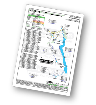
Maggie's Bridge (Loweswater) - Loweswater - High Nook Farm - Highnook Beck - Holme Wood - Holme Beck - Burnbank Fell - Sharp Knott - Blake Fell - Fothergill Head - Gavel Fell - Grain Gill - Whiteoak Moss - Hen Comb - Thrang Crags - Mosedale (Loweswater) - Mosedale Beck (Loweswater) - Mellbreak - Mellbreak (North Top) - White Crag - Loweswater Village - Maggie's Bridge (Loweswater)
|
Vital Statistics:
| Length: | 7.75 miles (12.5 km) |
| Ascent: | 1,923ft (586m) |
| Time: | 4.75hrs |
| Grade: | |
Route Summary:
Maggie's Bridge (Loweswater) - Loweswater - Darling Fell - Crabtree Beck - Low Fell (South Top) - Low Fell - Fellbarrow - Mosser Fell - Wilkes How - Waterend Youth Hostel - Hudson Place Farm - Holme Wood - Watergate Farm - Maggie's Bridge (Loweswater)
|
Vital Statistics:
| Length: | 6.5 miles (10.5 km) |
| Ascent: | 2,025ft (617m) |
| Time: | 4½ hrs |
| Grade: | |

Route Summary:
Maggie's Bridge (Loweswater) - Loweswater - High Nook Farm - Highnook Beck - Holme Wood - Burnbank Fell - Sharp Knott - Blake Fell - Fothergill Head - Gavel Fell - Black Crag (Gavel Fell) - Highnook Beck - Maggie's Bridge (Loweswater)
|
Vital Statistics:
| Length: | 6.25 miles (10 km) |
| Ascent: | 6ft (770m) |
| Time: | 5 hrs |
| Grade: | |

Route Summary:
Maggie's Bridge (Loweswater) - Loweswater - Kirkgate Farm - Raven Crag - White Crag - Mellbreak (North Top) - Mellbreak - Mosedale Beck (Loweswater) - Thrang Crags - Hen Comb - Little Dodd (Loweswater Fell) - Mosedale Beck (Loweswater) - Kirkgate Farm - Loweswater - Maggie's Bridge (Loweswater)
|
Vital Statistics:
| Length: | 15.25 miles (24.5 km) |
| Ascent: | 4,125ft (1,257m) |
| Time: | 9.75hrs |
| Grade: |  |

Route Summary:
Ennerdale Weir - Ennerdale Water - Silver Cove Beck - Woundell Beck - Little Gowder Crag - Haycock - Caw Fell - Silver Cove - Iron Crag - Whoap - Lank Rigg - Crag Fell - Grike - Ennerdale Weir
|
Vital Statistics:
| Length: | 11.75 miles (19 km) |
| Ascent: | 2,970ft (905m) |
| Time: | 7½ hrs |
| Grade: | |
Route Summary:
Ennerdale Weir - Ennerdale Water - Silver Cove Beck - Woundell Beck - Caw Fell - Silver Cove - Iron Crag - Crag Fell - Grike - Ennerdale Weir
|
Vital Statistics:
| Length: | 7.75 miles (12.5 km) |
| Ascent: | 2,028ft (618m) |
| Time: | 5½ hrs |
| Grade: | |
Route Summary:
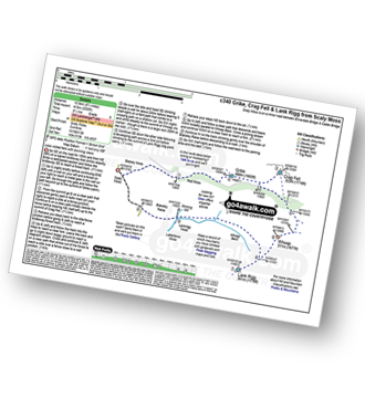
Scaly Moss - Blackely Moss - Heckbarley Wood - Red Moss - Grike - Crag Fell - Black Pots - Whoap - Lank Rigg - Whoap Beck - Lankrigg Moss - Stinking Gill - Blackeley Raise - Whorl Gill - Scaly Moss
|
Vital Statistics:
| Length: | 6.5 miles (10.5 km) |
| Ascent: | 1,877ft (572m) |
| Time: | 4.25hrs |
| Grade: | |
Route Summary:
Lanthwaite - Scale Hill - Scalehill Bridge - Muncaster House - Loweswater - Low Park - Mellbreak (North Top) - Mellbreak - Black Beck (Mosedale) - Scale Knott - Scale Beck - High Ling Crag - Low Ling Crag - Crummock Water - Lanthwaite
|
Vital Statistics:
| Length: | 8.75 miles (14 km) |
| Ascent: | 1,884ft (574m) |
| Time: | 5 hrs |
| Grade: | |
Route Summary:
Lanthwaite - Acorn Cottage - Crummockwater Cottages and Foulsyke - Pottergill - Raven Crag (Low Fell) - Low Fell - Low Fell (South Top) - Fellbarrow - Mosser Fell - Wilkes How - Waterend Youth Hostel - Hudson Place Farm - Holme Wood - Watergate Farm - Maggie's Bridge (Loweswater) - Loweswater - Lanthwaite
|
Vital Statistics:
| Length: | 7.25 miles (11.5 km) |
| Ascent: | 683ft (208m) |
| Time: | 3.25hrs |
| Grade: | |

Route Summary:
Bowness Knott Car Park - Bowness Plantations - River Liza - Ennerdale Water - Coast To Coast Path - Robin Hood's Chair - Anglers' Crag - Ennerdale Weir - River Ehen - Ennerdale Water - Bowness Knott Car Park
Not familiar with the area around CA14?
See these 30 nearest walks to UK Postcode CA14 on a google map
|
Vital Statistics:
| Length: | 11.25 miles (18 km) |
| Ascent: | 3,275ft (998m) |
| Time: | 7½ hrs |
| Grade: | |

Route Summary:
Bowness Knott Car Park Ennerdale Water - Char Dub - Silver Cove Beck - Woundell Beck - Caw Fell - Little Gowder Crag - Haycock - Great Scoat Fell - Scoat Fell (Little Scoat Fell) - Steeple - Long Crag - Moss Dub - Lingmell Plantation - Bowness Knott Car Park Ennerdale Water.
|
Vital Statistics:
| Length: | 18.75 miles (30 km) |
| Ascent: | 7,309ft (2,408m) |
| Time: | 14.75hrs |
| Grade: | |

Route Summary:
Bowness Knott Car Park Ennerdale - Low Gillerthwaite Field Centre - High Gillerthwaite Yourth Hostel - Red Pike (Buttermere) - High Stile - High Crag (Buttermere) - Seat (Buttermere) - Scarth Gap - Hay Stacks (Haystacks) - Innominate Tarn - Blackbeck Tarn - Black Beck - Green Crag (Buttermere) - Great Round How - Brandreth - Gillercomb Head - Green Gable - Windy Gap - Great Gable - Westmorland Cairn - Beck Head - Beckhead Tarn - Kirk Fell (East Top) - Kirk Fell - Black Sail Pass - Looking Stead (Pillar) - High Level Route - Robinson's Cairn - Pillar - Wind Gap - Black Crag (Pillar) - High Beck - Low Beck - Ennerdale.
|
Vital Statistics:
| Length: | 7.25 miles (11.5 km) |
| Ascent: | 3,180ft (969m) |
| Time: | 5.75hrs |
| Grade: | |

Route Summary:
Hopebeck - Hope Beck - Swinside (Whinlatter) - Hope Gill - Ladyside Pike - Hopegill Head - Hobcarton Crag - Grisedale Pike - Hopegill Head - Gasgale Crags - Whiteside (Crummock) - Whiteside (Crummock) (West Top) - Dodd (Whiteside) - Hopebeck
|
Vital Statistics:
| Length: | 7.25 miles (11.5 km) |
| Ascent: | 3,164ft (964m) |
| Time: | 5.75hrs |
| Grade: | |

Route Summary:
Lanthwaite Green - Liza Beck - Whin Ben - Whiteside (Crummock) (West Top) - Whiteside (Crummock) - Gasgale Crags - Hopegill Head - Hobcarton Crag - Sand Hill - Coledale Hause - Grasmoor - Liza Beck - Gasgale Gill - Lanthwaite
|
Vital Statistics:
| Length: | 8.5 miles (13.5 km) |
| Ascent: | 2,977ft (907m) |
| Time: | 6 hrs |
| Grade: | |
Route Summary:
Lanthwaite Green - Liza Beck - Gasgale Crags - Gasgale Gill - Coledale Hause - Grasmoor - Wandope - Whiteless Edge - Whiteless Pike - Whiteless Breast - Squat Beck - High Rannerdale - Crummock Water - Lanthwaite Green
|
Vital Statistics:
| Length: | 7 miles (11 km) |
| Ascent: | 3,243ft (988m) |
| Time: | 5.75hrs |
| Grade: | |

Route Summary:
Lanthwaite Green - Grasmoor - Wandope - Whiteless Edge - Whiteless Pike - Whiteless Breast - Low Bank - Rannerdale Knotts - Crummock Water - Lanthwaite Green
|
Vital Statistics:
| Length: | 9.75 miles (15.5 km) |
| Ascent: | 4,043ft (1,232m) |
| Time: | 7.75hrs |
| Grade: | |

Route Summary:
Lanthwaite Green - Liza Beck - Whin Ben - Whiteside (Crummock) (West Top) - Whiteside (Crummock) - Gasgale Crags - Hopegill Head - Sand Hill - Coledale Hause - Grasmoor - Wandope - Whiteless Edge - Whiteless Pike - Whiteless Breast - Low Bank - Rannerdale Knotts - Crummock Water - Hause Point - Lanthwaite Green
|
Vital Statistics:
| Length: | 9 miles (14.5 km) |
| Ascent: | 3,699ft (1,127m) |
| Time: | 7 hrs |
| Grade: | |

Route Summary:
Lanthwaite Green - Liza Beck - Whin Ben - Whiteside (Crummock) (West Top) - Whiteside (Crummock) - Gasgale Crags - Hopegill Head - Hobcarton Crag - Sand Hill - Coledale Hause - Grasmoor - Wandope - Whiteless Edge - Whiteless Pike - Whiteless Breast - Squat Beck - High Rannerdale - Crummock Water - Lanthwaite Green
|
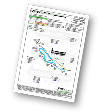
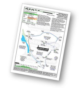
Vital Statistics:
| Length: | 8.25 miles (13 km) |
| Ascent: | 1,549ft (472m) |
| Time: | 4½ hrs |
| Grade: | |
Route Summary:
St Bees Beach - Wainwright's Coast to Coast Walk - Pattering Holes - South Head - Tomlin - St Bees Head - Fleswick - Cloven Barth - St Bees Lighthouse - North Head - Sandwith - Townhead - Demesne Farm - Bell House - Stanley - Pow Beck - Abbey Wood - St Bees - St Bees Beach
|
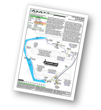
Vital Statistics:
| Length: | 2.5 miles (4 km) |
| Ascent: | 794ft (242m) |
| Time: | 2 hrs |
| Grade: |  |
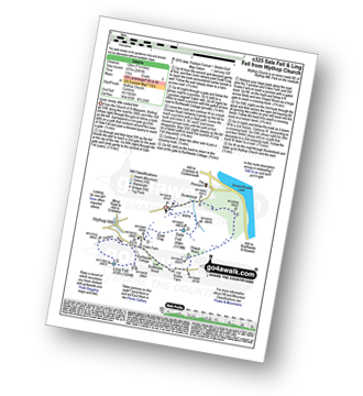
Route Summary:
Brumstone Bridge - Eskin Farm - Corpse Road - Ling Fell (Wythop) - Burthwaite Cottage - Brumstone Bridge
|
Vital Statistics:
| Length: | 8.75 miles (14 km) |
| Ascent: | 1,854ft (565m) |
| Time: | 5 hrs |
| Grade: | |

Route Summary:
Friar Well - Friar Gill - River Calder - Tongue How - Town Bank - Lank Rigg - Whoap - Whoap Beck - Stinking Gill - Lankrigg Moss - Latterbrow Moss - Latterbrow Beck - Friar Well
|
Vital Statistics:
| Length: | 7.5 miles (12 km) |
| Ascent: | 2,091ft (637m) |
| Time: | 5 hrs |
| Grade: | |
Route Summary:
Church of St Margaret - Wythop Mill - Sale Fell - Dodd Crag - Wythop Beck - Esking Farm - Corpse Road - Ling Fell (Wythop) - Burthwaite Cottage - Old Scale - Chapel Wood - Routenbeck - Wythop.
|
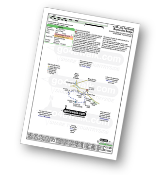
Vital Statistics:
| Length: | 2.5 miles (4 km) |
| Ascent: | 748ft (228m) |
| Time: | 1.75hrs |
| Grade: | |

|
Vital Statistics:
| Length: | 16 miles (25.5 km) |
| Ascent: | 6,285ft (1,915m) |
| Time: | 12.25hrs |
| Grade: | |
Route Summary:
Buttermere - Scale Force - Scale Beck - Blea Crag - Great Borne - Starling Dodd - Little Dodd (Ennerdale) - Ling Comb - Lingcomb Edge - Red Pike (Buttermere) - Dodd (Buttermere) - Red Pike (Buttermere) - High Stile - High Crag (Buttermere) - Gamlin End - Seat (Buttermere) - Scarth Gap - Hay Stacks (Haystacks) - Innominate Tarn - Blackbeck Tarn - Black Beck - Green Crag (Buttermere) - Warnscale Beck - Dubs Hut - Dubs Quarry - Fleetwith Pike - Honister Crag (Black Star) - Fleetwith Pike - Fleetwith Edge - Gatesgarth - Buttermere
|
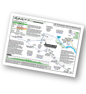
Vital Statistics:
| Length: | 8.75 miles (14 km) |
| Ascent: | 3,390ft (1,033m) |
| Time: | 6.25hrs |
| Grade: | |

Route Summary:
Buttermere - Scale Force - Scale Beck - Blea Crag - Lingcomb Edge - Red Pike (Buttermere) - High Stile - High Crag (Buttermere) - Gamlin End - Seat (Buttermere) - Scarth Gap - Burtness Wood - Sourmilk Gill - Buttermere
Not familiar with the area around CA14?
See these 30 nearest walks to UK Postcode CA14 on a google map


