Wainwright, Dewey & OS Trig Point Icon

Rosthwaite Fell (Bessyboot)
551m (1808ft)

The Southern Fells, The Lake District, Cumbria, England

The summit of Rosthwaite Fell (Bessyboot) is marked by an Ordnance Survey Trig Point.


Record Rosthwaite Fell (Bessyboot) as Bagged, Climbed & Conquered


Wainwright Icon

Wainwright
(No. 148)

English Dewey Icon

English Dewey
68th in England,
157th in England & Wales

English Trig Point Icon


English Trig Point (Pillar)

Walk Rosthwaite Fell (Bessyboot) walking UK Mountains in The Southern Fells The Lake District National Park Cumbria, England

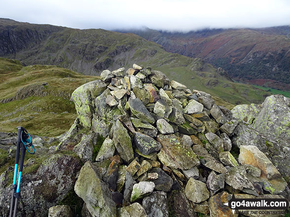
Rosthwaite Fell (Bessyboot) Summit

Photo: John Antrobus

You can find Rosthwaite Fell (Bessyboot) & all the walks that climb it on these unique free-to-access Interactive Walk Planning Maps: (click/TAP to select)

The Lake District National Park


1:25,000 scale OS Explorer Map (the ones with orange/yellow covers):

OL6 The English Lakes - South Western area


1:50,000 scale OS Landranger Maps (the ones with pink/magenta covers):

89 West Cumbria, Cockermouth & Wast Water


90 Penrith & Keswick, Ambleside


See Rosthwaite Fell (Bessyboot) and the surrounding tops on our free-to-access 'Google Style' Peak Bagging Maps:

See Rosthwaite Fell (Bessyboot) and the surrounding tops on our downloadable PDF Peak Bagging Maps:

NB: Whether you print off a copy on to paper or download it to your phone, these PDF Peak Baggers Maps will prove incredibly useful when your are up there on the tops and you cannot get a phone signal!


You can walk to the top of Rosthwaite Fell (Bessyboot) by using either of these 2 easy‑to‑follow route maps:
Walking Boot Print Icon

Walk c139 Allen Crags, Glaramara and Seathwaite Fell from Seatoller

Peak bagging heaven

Walk GPS Icon
Walk GPX Icon
Walk PDF Icon

Vital Statistics:

Length: 10.5ml (17km)
Ascent:3,407ft (1,038m)
Time:7.25hrs
Grade:Walk Grade 7 Icon (Hard)
Walking Boot Print Icon

Walk c395 Glaramara, Allen Crags and Langstrath from Stonethwaite

Terrific views - Terrific for the Peak Baggers

Walk GPS Icon
Walk GPX Icon
Walk PDF Icon

Vital Statistics:

Length: 10.5ml (17km)
Ascent:3,384ft (1,031m)
Time:7.25hrs
Grade:Walk Grade 7 Icon (Hard)

Other walkers who hiked, climbed, bagged and summited Rosthwaite Fell (Bessyboot) Fellow go4awalkers who have already walked, climbed, summited & bagged Rosthwaite Fell (Bessyboot)

Pete George walked up Rosthwaite Fell (Bessyboot) on April 14th, 2024 [from/via/route] from Seathwaite. With Pete Sisson [with] Roco & Pete Sisson [weather] Warm spring day

Richard Fulcher climbed Rosthwaite Fell (Bessyboot) on July 8th, 2024 [from/via/route] Parked at the NT car park at Seatoller (plenty of room at 11:30 on a Monday in July!). We set off down the road towards Strands Bridge, turning right to take the public footpath around the Old Mill Cottage. We then followed the path that takes you across a rock strewn hillside, gradually climbing up by Rottenstone Gill to Tarn At Leaves. After eating our sandwiches we then completed the short hike up to the top of Bessyboot. We met a fellow walker at the top who had climbed up from Langstrath - he said he'd never attempt it again! We returned by a slightly different route through an unnamed gully before finding the 'official' path down. At the bottom of the hill we crossed over Combe Gill to follow a track back down to the road. For further variation we crossed over the road & took a footpath back to the car park. [with] Jen [weather] A fine day, cloudy with spells of sunshine, warm. - Great views all the way & especially from the top.

Christine Shepherd bagged Rosthwaite Fell (Bessyboot) on May 28th, 2009 [from/via/route] Walked from Borrowdale using walk c139 Climbed again with a group from Head4theHills on 16.10.21 from Stonethwaite Church Climbed for a third time on a lovely day via Big Stranger Gill on 9.08.2023 [with] On my own [weather] Very hot in the morning, clouding over & becoming very wet & misty in the afternoon.

Ian Ashton hiked Rosthwaite Fell (Bessyboot) on April 29th, 2023 [with] Solo 17 miler

John Tippins summited Rosthwaite Fell (Bessyboot) on October 27th, 2022 [from/via/route] From Seatoller [with] Alone [weather] Dry to start with & mild - t-shirt mild for the ascent. Started to rain mid-morning, then rained on & off all day. Very low cloud - in cloud for most of the walk. Wind quite calm. - Not an enjoyable walk, particularly the stretch from Rosthwaite to Glaramara. Confronted with many sheer rock faces that you have to find a way over. And I forgot the warning about the scree at Aaron Crags until I was part way down. It was bad. 'Not for the faint hearted' - you're not kidding.

Michael Nolan conquered Rosthwaite Fell (Bessyboot) on September 20th, 2022 [with] Morag [weather] Lovely

Richard Marchant scaled Rosthwaite Fell (Bessyboot) on July 13th, 2022 [from/via/route] Started out from Seathwaite up to Stockley Bridge & right then up to Greenhow Knott, from here I went straight South up through Aaron Crags on to Seathwaite Fell to Great Stack & Sprinkling Tarn then Esk Hause. From here up to Allen Crags & then ridge along to Glaramara on to Combe Head, East to Combe Door along to Rosthwaite Cam & finally Rosthwaite Fell (Bessy Boot) down to Seatoller & back along the road to Seathwaite & the car [with] On my Own [weather] Clear hot sunny day with little or no breeze.

Nick Dobson walked up Rosthwaite Fell (Bessyboot) on August 30th, 2021 [from/via/route] Stonethwaite, ascending up via Big Stanger Gill [with] Margaret & Ralph. [weather] Warm but cloudy day with the odd occasional light rain. - We considered going on to Glaramara, but with low cloud enveloping the bigger peaks decided against it on this occasion, descending via Combe Gill round the Northern Spur of the fell & back to Stonethwaite 182 done, 32 remaining.

Paul Talbot-Greaves climbed Rosthwaite Fell (Bessyboot) on July 29th, 2021 [from/via/route] Seatoller [with] Paul Drury and Andy Bailey [weather] Rain most of day. High winds & low cloud with poor visibility on tops. Difficult terrain & challenging navigation. Soaked...even boots on inside.

Chris Sheard bagged Rosthwaite Fell (Bessyboot) on July 12th, 2021 [from/via/route] Along from Stonethwaite up Stanger Gill [with] George [weather] Very muggy, slight winds very sweaty, clagged in at top - Nice top, with impressive views when heavy mist lifted - Tarn at Leaves a good handrail

To add (or remove) your name and experiences on this page - Log On and edit your Personal Mountain Bagging Record

. . . [see more walk reports]


More Photographs & Pictures of views from, on or of Rosthwaite Fell (Bessyboot)

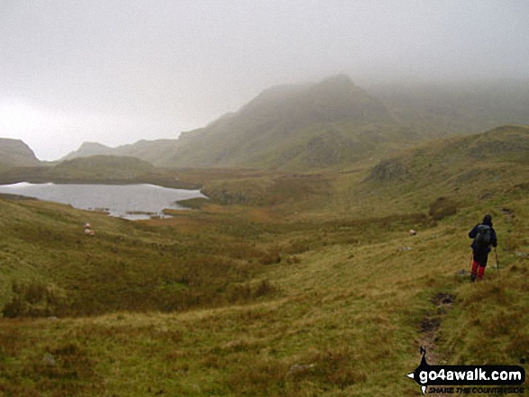
Approaching Rosthwaite Cam (Rosthwaite Fell) and Tarn at Leaves from Rosthwaite Fell (Bessyboot)

Approaching Rosthwaite Cam (Rosthwaite Fell) and Tarn at Leaves from Rosthwaite Fell (Bessyboot)

Photo: John Antrobus (7)

Me on the summit of Rosthwaite Fell (Bessyboot)

Me on the summit of Rosthwaite Fell (Bessyboot)

Photo: Christine Shepherd (850)

Tarn at Leaves from Rosthwaite Fell (Bessyboot)

Tarn at Leaves from Rosthwaite Fell (Bessyboot)

Photo: Christine Shepherd (849)

Rosthwaite Fell (Bessyboot) from above Hanging Haystack Crag

Rosthwaite Fell (Bessyboot) from above Hanging Haystack Crag

Photo: John Antrobus (4)

*Scafell Pike (far left back) and The Borrowdale Fells featuring Allen Crags, High House Tarn Top, Red Beck Top, Looking Stead, Glaramara, Comb Head, Comb Door Top, Dovenest Top and Rosthwaite Fell (Bessyboot) from High Raise (Langdale)

*Scafell Pike (far left back) and The Borrowdale Fells featuring Allen Crags, High House Tarn Top, Red Beck Top, Looking Stead, Glaramara, Comb Head, Comb Door Top, Dovenest Top and Rosthwaite Fell (Bessyboot) from High Raise (Langdale)

Photo: Tim Hope (32)

Rosthwaite Fell (Bessyboot) summit cairn

Rosthwaite Fell (Bessyboot) summit cairn

Photo: Christine Shepherd (851)


Send us your photographs and pictures on, of, or from Rosthwaite Fell (Bessyboot)

If you would like to add your walk photographs and pictures featuring views from, on or of Rosthwaite Fell (Bessyboot) to this page, please send them as email attachments (configured for any computer) along with your name to:


and we shall do our best to publish them.

(Guide Resolution = 300dpi. At least = 660pixels (wide) x 440 pixels (high).)

Send us your photographs and pictures on, of, or from Rosthwaite Fell (Bessyboot) via Facebook

You can also submit photos via our Facebook Page.

NB. Please indicate where each photo was taken.


Do not miss our pick of the Best Walks in the UK


Follow go4awalk.com on Twitter Follow go4awalk.com on Facebook


Home


Find new Friends to go walking with

Walk all 214 Wainwrights in just 59 Walks. Download GPS Waypoints - Great Walks you must not miss!

Walk The Yorkshire Three Peaks Challenge Walk - All the Latest Route Information, GPS Waypoints and Split Times to keep you on Schedule

Walk The British Three Peaks Challenge Walk - All the Latest Route Information and GPS Waypoints

See our pick of The Best Walks in The Lake District - Great Walks you must not miss!

Walk our pick of the Best Lake District Ridge Walks - Great Walks you must not miss!

Walk our pick of the Best Lake District Walks to do in the rain - Great Walks you must not miss!

Walk our pick of The Best Walks in Snowdonia - Great Walks you must not miss!

Walk our pick of The Best Ridge Walks in Wales - Walks you must not miss!

Walk our pick of The Best Walks in The Brecon Beacons - Great Walks you must not miss!

Walk our pick of The Best Walks in The Yorkshire Dales - Walks you must not miss!

Walk our pick of The Best Walks in The Peak District - Walks you must not miss!

Walk our pick of The Best Walks in The Forest of Bowland - Walks you must not miss!

Walk our pick of The Best Walks in Shropshire - Walks you must not miss!

Walk our pick of The Best Walks in Cheshire - Walks you must not miss!

Walk our pick of The Best Walks in Lancashire - Walks you must not miss!

Not sure where to walk next? Try Peak Bagging - Great Walks you must not miss!

Not sure where to walk next? Walk part of a National Trail - Great Walks you must not miss!

Walks with Downloadable and Uploadable GPS Waypoint Data

Walking Kit and Gear Tested by Walkers

Full Site Search