All the Mountains, Peaks, Tops and Hills in England, England as a detailed list

England is defined as the whole of the country of England which includes the National Parks of Dartmoor, Exmoor, The Lake District, The Peak District, The North York Moors, Northumberland, The South Downs and The Yorkshire Dales, as well as The Chilterns, The Cotswolds, The Forest of Bowland, The North Peninnes, The Shropshire Hills and The South Peninnes.


If you count only the Deweys there are 180 tops to climb, bag & conquer and the highest point is Sugar Loaf (Horse Head Moor) at 609m (1,999ft).


Wainwright
214/0
Wainwrights
Hewitt
180/0
English
Mountains
Dewey
180/0
English
Deweys
nuttall
254/0
English
Nuttalls
Wainwright Outlying Fell
116/0
Wainwright
Outlying Fells
marilyn
174/0
English
Marilyns
Bridget
534/0
English
Bridgets
Trig Point
487/0
Trig
Points


To see all Mountains, Peaks, Tops and Hills displayed in different ways - see the options in the left-hand column and towards the bottom of this page.


LOG ON and RELOAD this page to show which Mountains, Peaks, Tops and Hills you have already climbed, bagged & conquered [. . . more]


Page 4 of 6    Go to page: 1 2 3 4 5 6


See this list in: Alphabetical Order | Height Order
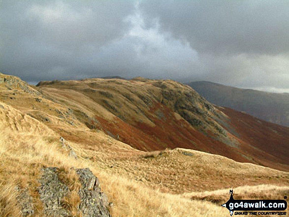
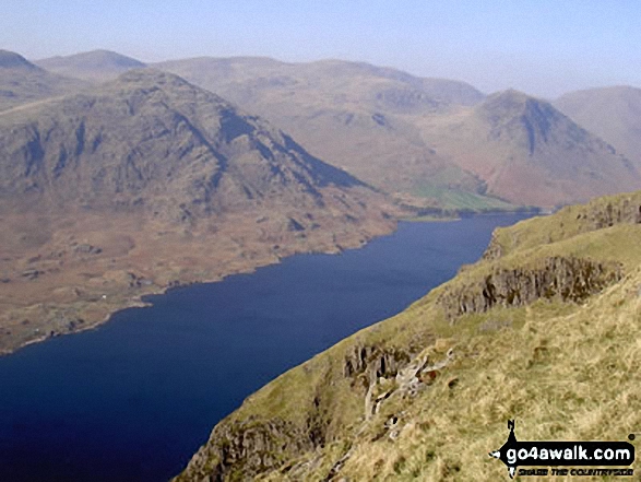
To reverse the order select the link again.


Mountain, Peak, Top or Hill:

Bagged


91. Bolt's Law (Hunstanworth)

541m (1,776ft)


Got a good photo of
Bolt's Law (Hunstanworth)?

Send it in and we'll publish it here.

Photo
Submission
Details

  • Dewey (91st in England, 208th in England & Wales)
  • OS Trig Point

  • To walk, climb & bag Bolt's Law (Hunstanworth) use this easy to follow walk:

    Google Maps Icon
    See the location of Bolt's Law (Hunstanworth) and walks up it on a google Map

    Bolt's Law (Hunstanworth) is on interactive maps:

  • OS Explorer (Orange Covers): 307
  • OS Landranger (Pink Covers): 87

  • Bolt's Law (Hunstanworth) is on Peak Bagging Map and Hill Tick List:


    92. Lank Rigg

    541m (1,775ft)

  • Wainwright (No. 153)
  • Dewey (92nd in England, 209th in England & Wales)
  • OS Trig Point

  • To walk, climb & bag Lank Rigg use any of these easy to follow walks:

    Google Maps Icon
    See the location of Lank Rigg and walks up it on a google Map

    Lank Rigg is on interactive maps:

  • OS Explorer (Orange Covers): OL4
  • OS Landranger (Pink Covers): 89

  • Lank Rigg is on Peak Bagging Map and Hill Tick List:

    *Version including the walk routes marked on it that you need to follow to Walk all 214 Wainwrights in just 59 walks.


    93. Brown Clee Hill (Abdon Burf)

    540m (1,772ft)

  • Dewey (93rd in England, 212th in England & Wales)
  • Marilyn (66th in England, 895th in GB)
  • OS Trig Point
  • Brown Clee Hill (Abdon Burf) is the highest point in the county of Shropshire


    To walk, climb & bag Brown Clee Hill (Abdon Burf) use this easy to follow walk:

    Google Maps Icon
    See the location of Brown Clee Hill (Abdon Burf) and walks up it on a google Map

    Brown Clee Hill (Abdon Burf) is on interactive maps:

  • OS Explorer (Orange Covers): 217
  • OS Landranger (Pink Covers): 137 and 138

  • Brown Clee Hill (Abdon Burf) is on Peak Bagging Map and Hill Tick List:


    94. Cuns Fell

    539m (1,769ft)

  • Dewey (94th in England, 215th in England & Wales)

  • To walk, climb & bag Cuns Fell use this easy to follow walk:

    Google Maps Icon
    See the location of Cuns Fell and walks up it on a google Map

    Cuns Fell is on interactive maps:

  • OS Explorer (Orange Covers): OL31
  • OS Landranger (Pink Covers): 91

  • Cuns Fell is on Peak Bagging Map and Hill Tick List:


    95. Great Mis Tor

    539m (1,768ft)

  • Dewey (95th in England, 216th in England & Wales)

  • To walk, climb & bag Great Mis Tor use any of these easy to follow walks:

    Google Maps Icon
    See the location of Great Mis Tor and walks up it on a google Map

    Great Mis Tor is on interactive maps:

  • OS Explorer (Orange Covers): OL28
  • OS Landranger (Pink Covers): 191

  • Great Mis Tor is on Peak Bagging Map and Hill Tick List:


    96. Back Tor (Derwent Edge)

    538m (1,766ft)

  • Dewey (96th in England, 219th in England & Wales)
  • OS Trig Point

  • To walk, climb & bag Back Tor (Derwent Edge) use any of these easy to follow walks:

    Google Maps Icon
    See the location of Back Tor (Derwent Edge) and walks up it on a google Map

    Back Tor (Derwent Edge) is on interactive maps:

  • OS Explorer (Orange Covers): OL1
  • OS Landranger (Pink Covers): 110

  • Back Tor (Derwent Edge) is on Peak Bagging Map and Hill Tick List:


    97. Parson's Pulpit

    538m (1,765ft)

  • Dewey (97th in England, 222nd in England & Wales)
  • OS Trig Point

  • To walk, climb & bag Parson's Pulpit use either of these easy to follow walks:

    Google Maps Icon
    See the location of Parson's Pulpit and walks up it on a google Map

    Parson's Pulpit is on interactive maps:

  • OS Explorer (Orange Covers): OL2
  • OS Landranger (Pink Covers): 98

  • Parson's Pulpit is on Peak Bagging Map and Hill Tick List:


    98. Calf Crag

    537m (1,762ft)

  • Wainwright (No. 155)
  • Dewey (99th in England, 230th in England & Wales)

  • To walk, climb & bag Calf Crag use any of these easy to follow walks:

    Google Maps Icon
    See the location of Calf Crag and walks up it on a google Map

    Calf Crag is on interactive maps:

  • OS Explorer (Orange Covers): OL4 and OL5 OL6 OL7
  • OS Landranger (Pink Covers): 90

  • Calf Crag is on Peak Bagging Map and Hill Tick List:

    *Version including the walk routes marked on it that you need to follow to Walk all 214 Wainwrights in just 59 walks.


    99. Great Mell Fell

    537m (1,762ft)

  • Wainwright (No. 154)
  • Dewey (98th in England, 229th in England & Wales)
  • Marilyn (67th in England, 901st in GB)
  • OS Trig Point

  • To walk, climb & bag Great Mell Fell use either of these easy to follow walks:

    Google Maps Icon
    See the location of Great Mell Fell and walks up it on a google Map

    Great Mell Fell is on interactive maps:

  • OS Explorer (Orange Covers): OL5
  • OS Landranger (Pink Covers): 90

  • Great Mell Fell is on Peak Bagging Map and Hill Tick List:

    *Version including the walk routes marked on it that you need to follow to Walk all 214 Wainwrights in just 59 walks.


    100. Newton Tors

    537m (1,762ft)

  • Dewey (100th in England, 233rd in England & Wales)
  • OS Trig Point

  • We hope to have walks that climb & bag Newton Tors very soon

    Google Maps Icon
    See the location of Newton Tors and walks up it on a google Map

    Newton Tors is on interactive maps:

  • OS Explorer (Orange Covers): OL16
  • OS Landranger (Pink Covers): 74 and 75

  • A go4awalk.com Peak Bagging Map and Hill Tick List featuring Newton Tors will be available soon.


    101. Castle Knott

    536m (1,759ft)

  • Dewey (102nd in England, 237th in England & Wales)

  • To walk, climb & bag Castle Knott use this easy to follow walk:

    Google Maps Icon
    See the location of Castle Knott and walks up it on a google Map

    Castle Knott is on interactive maps:

  • OS Explorer (Orange Covers): OL2
  • OS Landranger (Pink Covers): 97

  • Castle Knott is on Peak Bagging Map and Hill Tick List:


    102. Stiperstones (Manstone Rock)

    536m (1,759ft)

  • Dewey (101st in England, 234th in England & Wales)
  • Marilyn (68th in England, 904th in GB)
  • OS Trig Point

  • To walk, climb & bag Stiperstones (Manstone Rock) use either of these easy to follow walks:

    Google Maps Icon
    See the location of Stiperstones (Manstone Rock) and walks up it on a google Map

    Stiperstones (Manstone Rock) is on interactive maps:

  • OS Explorer (Orange Covers): 217
  • OS Landranger (Pink Covers): 137

  • Stiperstones (Manstone Rock) is on Peak Bagging Map and Hill Tick List:


    103. Harland Hill

    535m (1,756ft)


    Got a good photo of
    Harland Hill?

    Send it in and we'll publish it here.

    Photo
    Submission
    Details

  • Dewey (104th in England, 240th in England & Wales)

  • We hope to have walks that climb & bag Harland Hill very soon

    Google Maps Icon
    See the location of Harland Hill and walks up it on a google Map

    Harland Hill is on interactive maps:

  • OS Explorer (Orange Covers): OL30
  • OS Landranger (Pink Covers): 98

  • Harland Hill is on Peak Bagging Map and Hill Tick List:


    104. Whin Rigg

    535m (1,756ft)

  • Wainwright (No. 156)
  • Dewey (103rd in England, 239th in England & Wales)

  • To walk, climb & bag Whin Rigg use any of these easy to follow walks:

    Google Maps Icon
    See the location of Whin Rigg and walks up it on a google Map

    Whin Rigg is on interactive maps:

  • OS Explorer (Orange Covers): OL6
  • OS Landranger (Pink Covers): 89

  • Whin Rigg is on Peak Bagging Map and Hill Tick List:

    *Version including the walk routes marked on it that you need to follow to Walk all 214 Wainwrights in just 59 walks.


    105. Blea Moor (Crag of Blea Moor)

    535m (1,755ft)


    Got a good photo of
    Blea Moor (Crag of Blea Moor)?

    Send it in and we'll publish it here.

    Photo
    Submission
    Details

  • Dewey (105th in England, 242nd in England & Wales)

  • We hope to have walks that climb & bag Blea Moor (Crag of Blea Moor) very soon

    Google Maps Icon
    See the location of Blea Moor (Crag of Blea Moor) and walks up it on a google Map

    Blea Moor (Crag of Blea Moor) is on interactive maps:

  • OS Explorer (Orange Covers): OL2
  • OS Landranger (Pink Covers): 98

  • Blea Moor (Crag of Blea Moor) is on Peak Bagging Map and Hill Tick List:


    106. Brownley Hill (Kevelin Moor)

    533m (1,749ft)


    Got a good photo of
    Brownley Hill (Kevelin Moor)?

    Send it in and we'll publish it here.

    Photo
    Submission
    Details

  • Dewey (107th in England, 249th in England & Wales)
  • OS Trig Point

  • We hope to have walks that climb & bag Brownley Hill (Kevelin Moor) very soon

    Google Maps Icon
    See the location of Brownley Hill (Kevelin Moor) and walks up it on a google Map

    Brownley Hill (Kevelin Moor) is on interactive maps:

  • OS Explorer (Orange Covers): OL31
  • OS Landranger (Pink Covers): 86 and 87

  • Brownley Hill (Kevelin Moor) is on Peak Bagging Map and Hill Tick List:


    107. Titterstone Clee Hill

    533m (1,749ft)

  • Dewey (106th in England, 247th in England & Wales)
  • Marilyn (69th in England, 912th in GB)
  • OS Trig Point

  • To walk, climb & bag Titterstone Clee Hill use this easy to follow walk:

    Google Maps Icon
    See the location of Titterstone Clee Hill and walks up it on a google Map

    Titterstone Clee Hill is on interactive maps:

  • OS Explorer (Orange Covers): 217
  • OS Landranger (Pink Covers): 137 and 138

  • Titterstone Clee Hill is on Peak Bagging Map and Hill Tick List:


    108. Hameldown Tor (Hamel Down)

    532m (1,746ft)


    Got a good photo of
    Hameldown Tor (Hamel Down)?

    Send it in and we'll publish it here.

    Photo
    Submission
    Details

  • Dewey (109th in England, 257th in England & Wales)
  • OS Trig Point

  • We hope to have walks that climb & bag Hameldown Tor (Hamel Down) very soon

    Google Maps Icon
    See the location of Hameldown Tor (Hamel Down) and walks up it on a google Map

    Hameldown Tor (Hamel Down) is on interactive maps:

  • OS Explorer (Orange Covers): OL28
  • OS Landranger (Pink Covers): 191

  • Hameldown Tor (Hamel Down) is on Peak Bagging Map and Hill Tick List:


    109. Steeperton Tor

    532m (1,746ft)

  • Dewey (110th in England, 258th in England & Wales)

  • To walk, climb & bag Steeperton Tor use either of these easy to follow walks:

    Google Maps Icon
    See the location of Steeperton Tor and walks up it on a google Map

    Steeperton Tor is on interactive maps:

  • OS Explorer (Orange Covers): OL28
  • OS Landranger (Pink Covers): 191

  • Steeperton Tor is on Peak Bagging Map and Hill Tick List:


    110. Uldale Head (Howgills)

    532m (1,746ft)

  • Dewey (108th in England, 254th in England & Wales)

  • To walk, climb & bag Uldale Head (Howgills) use either of these easy to follow walks:

    Google Maps Icon
    See the location of Uldale Head (Howgills) and walks up it on a google Map

    Uldale Head (Howgills) is on interactive maps:

  • OS Explorer (Orange Covers): OL19
  • OS Landranger (Pink Covers): 91

  • Uldale Head (Howgills) is on Peak Bagging Map and Hill Tick List:


    111. High Wether Howe

    531m (1,743ft)

  • Dewey (111th in England, 260th in England & Wales)
  • Wainwright Outlying Fell (No. 13)

  • To walk, climb & bag High Wether Howe use either of these easy to follow walks:

    Google Maps Icon
    See the location of High Wether Howe and walks up it on a google Map

    High Wether Howe is on interactive maps:

  • OS Explorer (Orange Covers): OL5 and OL7
  • OS Landranger (Pink Covers): 90

  • A go4awalk.com Peak Bagging Map and Hill Tick List featuring High Wether Howe will be available soon.


    112. Proctor High Mark

    531m (1,743ft)

  • Dewey (112th in England, 261st in England & Wales)

  • To walk, climb & bag Proctor High Mark use either of these easy to follow walks:

    Google Maps Icon
    See the location of Proctor High Mark and walks up it on a google Map

    Proctor High Mark is on interactive maps:

  • OS Explorer (Orange Covers): OL2
  • OS Landranger (Pink Covers): 98

  • Proctor High Mark is on Peak Bagging Map and Hill Tick List:


    113. White Howe (Bannisdale)

    530m (1,739ft)

  • Dewey (113th in England, 264th in England & Wales)
  • Wainwright Outlying Fell (No. 14)
  • OS Trig Point

  • We hope to have walks that climb & bag White Howe (Bannisdale) very soon

    Google Maps Icon
    See the location of White Howe (Bannisdale) and walks up it on a google Map

    White Howe (Bannisdale) is on interactive maps:

  • OS Explorer (Orange Covers): OL7
  • OS Landranger (Pink Covers): 90

  • A go4awalk.com Peak Bagging Map and Hill Tick List featuring White Howe (Bannisdale) will be available soon.


    114. Caw (Dunnerdale Fells)

    529m (1,736ft)

  • Dewey (114th in England, 265th in England & Wales)
  • Wainwright Outlying Fell (No. 15)
  • OS Trig Point

  • To walk, climb & bag Caw (Dunnerdale Fells) use either of these easy to follow walks:

    Google Maps Icon
    See the location of Caw (Dunnerdale Fells) and walks up it on a google Map

    Caw (Dunnerdale Fells) is on interactive maps:

  • OS Explorer (Orange Covers): OL6
  • OS Landranger (Pink Covers): 96

  • A go4awalk.com Peak Bagging Map and Hill Tick List featuring Caw (Dunnerdale Fells) will be available soon.


    115. Wolfhole Crag

    528m (1,733ft)

  • Dewey (115th in England, 270th in England & Wales)
  • OS Trig Point

  • To walk, climb & bag Wolfhole Crag use this easy to follow walk:

    Google Maps Icon
    See the location of Wolfhole Crag and walks up it on a google Map

    Wolfhole Crag is on interactive maps:

  • OS Explorer (Orange Covers): OL41
  • OS Landranger (Pink Covers): 102 and 103

  • Wolfhole Crag is on Peak Bagging Map and Hill Tick List:


    116. Green Crag (Buttermere)

    528m (1,732ft)

  • Dewey (117th in England, 274th in England & Wales)

  • To walk, climb & bag Green Crag (Buttermere) use any of these easy to follow walks:

    Google Maps Icon
    See the location of Green Crag (Buttermere) and walks up it on a google Map

    Green Crag (Buttermere) is on interactive maps:

  • OS Explorer (Orange Covers): OL4
  • OS Landranger (Pink Covers): 89 and 90

  • Green Crag (Buttermere) is on Peak Bagging Map and Hill Tick List:

    *Version including the walk routes marked on it that you need to follow to Walk all 214 Wainwrights in just 59 walks.


    117. Shill Moor

    528m (1,732ft)

  • Dewey (118th in England, 275th in England & Wales)
  • OS Trig Point

  • To walk, climb & bag Shill Moor use this easy to follow walk:

    Google Maps Icon
    See the location of Shill Moor and walks up it on a google Map

    Shill Moor is on interactive maps:

  • OS Explorer (Orange Covers): OL16
  • OS Landranger (Pink Covers): 80

  • A go4awalk.com Peak Bagging Map and Hill Tick List featuring Shill Moor will be available soon.


    118. The Forest (Bannisdale)

    528m (1,732ft)

  • Dewey (116th in England, 273rd in England & Wales)
  • Wainwright Outlying Fell (No. 16)

  • We hope to have walks that climb & bag The Forest (Bannisdale) very soon

    Google Maps Icon
    See the location of The Forest (Bannisdale) and walks up it on a google Map

    The Forest (Bannisdale) is on interactive maps:

  • OS Explorer (Orange Covers): OL7
  • OS Landranger (Pink Covers): 90

  • A go4awalk.com Peak Bagging Map and Hill Tick List featuring The Forest (Bannisdale) will be available soon.


    119. Horse Stone (Horse Stone Naze)

    527m (1,730ft)

  • Dewey (119th in England, 278th in England & Wales)

  • To walk, climb & bag Horse Stone (Horse Stone Naze) use this easy to follow walk:

    Google Maps Icon
    See the location of Horse Stone (Horse Stone Naze) and walks up it on a google Map

    Horse Stone (Horse Stone Naze) is on interactive maps:

  • OS Explorer (Orange Covers): OL1
  • OS Landranger (Pink Covers): 110

  • Horse Stone (Horse Stone Naze) is on Peak Bagging Map and Hill Tick List:


    120. Ravens Knowe

    527m (1,729ft)


    Got a good photo of
    Ravens Knowe?

    Send it in and we'll publish it here.

    Photo
    Submission
    Details

  • Dewey (120th in England, 280th in England & Wales)

  • We hope to have walks that climb & bag Ravens Knowe very soon

    Google Maps Icon
    See the location of Ravens Knowe and walks up it on a google Map

    Ravens Knowe is on interactive maps:

  • OS Explorer (Orange Covers): OL16
  • OS Landranger (Pink Covers): 80

  • A go4awalk.com Peak Bagging Map and Hill Tick List featuring Ravens Knowe will be available soon.


    Page 4 of 6    Go to page: 1 2 3 4 5 6


    View all 1233 Mountains, Peaks, Tops and Hills in EnglandThe Peak District:


    Is there a Mountain, Peak, Top or Hill missing from the above google map or list?

    Let us know an we will add it to our database.


    Follow go4awalk.com on Twitter Follow go4awalk.com on Facebook


    Home


    Find new Friends to go walking with

    Walk all 214 Wainwrights in just 59 Walks. Download GPS Waypoints - Great Walks you must not miss!

    Walk The Yorkshire Three Peaks Challenge Walk - All the Latest Route Information, GPS Waypoints and Split Times to keep you on Schedule

    Walk The British Three Peaks Challenge Walk - All the Latest Route Information and GPS Waypoints

    See our pick of The Best Walks in The Lake District - Great Walks you must not miss!

    Walk our pick of the Best Lake District Ridge Walks - Great Walks you must not miss!

    Walk our pick of the Best Lake District Walks to do in the rain - Great Walks you must not miss!

    Walk our pick of The Best Walks in Snowdonia - Great Walks you must not miss!

    Walk our pick of The Best Ridge Walks in Wales - Walks you must not miss!

    Walk our pick of The Best Walks in The Brecon Beacons - Great Walks you must not miss!

    Walk our pick of The Best Walks in The Yorkshire Dales - Walks you must not miss!

    Walk our pick of The Best Walks in The Peak District - Walks you must not miss!

    Walk our pick of The Best Walks in The Forest of Bowland - Walks you must not miss!

    Walk our pick of The Best Walks in Shropshire - Walks you must not miss!

    Walk our pick of The Best Walks in Cheshire - Walks you must not miss!

    Walk our pick of The Best Walks in Lancashire - Walks you must not miss!

    Not sure where to walk next? Try Peak Bagging - Great Walks you must not miss!

    Not sure where to walk next? Walk part of a National Trail - Great Walks you must not miss!

    Walks with Downloadable and Uploadable GPS Waypoint Data

    Walking Kit and Gear Tested by Walkers

    Full Site Search
    Do not miss our pick of the Best Walks in Britain