The Mountains, Peaks, Tops and Hills in The Eastern Fells area of The Lake District, Cumbria with all the tops you have already bagged in first & then the ones you are yet to climb second.
The Eastern Fells area of The Lake District National Park, Cumbria is enclosed by:
- Threlkeld and Pooley Bridge to the North
- Grasmere and Thirlmere to the West
- Ambleside to the South
- The Kirkstone Pass and Ullswater to the East
If you count only the Wainwrights there are 35 tops to climb, bag & conquer and the highest point is Helvellyn at 950m (3,118ft).
To see these Mountains, Peaks, Tops and Hills displayed in different ways - see the options in the left-hand column and towards the bottom of this page.
![]() Your Personal Bagging Record for The Eastern Fells area of The Lake District
Your Personal Bagging Record for The Eastern Fells area of The Lake District
LOG ON and RELOAD this page to show which Mountains, Peaks, Tops and Hills you have already climbed, bagged & conquered [. . . more details]
Scroll down this list of mountains, peaks, tops & hills below and tap/click on each name (in blue) to locate it on the map above.
See this list in: Alphabetical Order | Height Order‡
To reverse the order select the link again.
Mountain, Peak, Top or Hill already bagged:
Bagged
Top yet to be climbed, bagged & conquered:
Bagged

![]()
1. Helvellyn
950m (3118ft)
Wainwright
See more details, photos, trip reports and easy-to-follow walks up Helvellyn
![]()
2. Nethermost Pike
891m (2924ft)
Wainwright
See more details, photos, trip reports and easy-to-follow walks up Nethermost Pike
![]()
3. Catstye Cam
890m (2921ft)
Wainwright
See more details, photos, trip reports and easy-to-follow walks up Catstye Cam
![]()
4. Raise (Helvellyn)
883m (2898ft)
Wainwright
See more details, photos, trip reports and easy-to-follow walks up Raise (Helvellyn)
![]()
5. Fairfield
873m (2865ft)
Wainwright
See more details, photos, trip reports and easy-to-follow walks up Fairfield
![]()
6. White Side
863m (2832ft)
Wainwright
See more details, photos, trip reports and easy-to-follow walks up White Side
![]()
7. Dollywaggon Pike
858m (2816ft)
Wainwright
See more details, photos, trip reports and easy-to-follow walks up Dollywaggon Pike
![]()
8. Great Dodd
857m (2813ft)
Wainwright
See more details, photos, trip reports and easy-to-follow walks up Great Dodd
![]()
9. Stybarrow Dodd
843m (2767ft)
Wainwright
See more details, photos, trip reports and easy-to-follow walks up Stybarrow Dodd
![]()
10. St Sunday Crag
841m (2760ft)
Wainwright
See more details, photos, trip reports and easy-to-follow walks up St Sunday Crag
![]()
11. Hart Crag
822m (2698ft)
Wainwright
See more details, photos, trip reports and easy-to-follow walks up Hart Crag
![]()
12. Dove Crag
792m (2599ft)
Wainwright
See more details, photos, trip reports and easy-to-follow walks up Dove Crag
![]()
13. Watson's Dodd
789m (2589ft)
Wainwright
See more details, photos, trip reports and easy-to-follow walks up Watson's Dodd
![]()
14. Red Screes
776m (2547ft)
Wainwright
See more details, photos, trip reports and easy-to-follow walks up Red Screes
![]()
15. Great Rigg
766m (2514ft)
Wainwright
See more details, photos, trip reports and easy-to-follow walks up Great Rigg
![]()
16. Hart Side
756m (2481ft)
Wainwright
See more details, photos, trip reports and easy-to-follow walks up Hart Side
![]()
17. Seat Sandal
736m (2417ft)
Wainwright
See more details, photos, trip reports and easy-to-follow walks up Seat Sandal
![]()
18. Clough Head
726m (2383ft)
Wainwright
See more details, photos, trip reports and easy-to-follow walks up Clough Head
![]()
19. Birkhouse Moor
718m (2356ft)
Wainwright
See more details, photos, trip reports and easy-to-follow walks up Birkhouse Moor
![]()
20. Sheffield Pike
676m (2218ft)
Wainwright
See more details, photos, trip reports and easy-to-follow walks up Sheffield Pike
![]()
21. High Pike (Scandale)
656m (2153ft)
Wainwright
See more details, photos, trip reports and easy-to-follow walks up High Pike (Scandale)
![]()
22. Middle Dodd
654m (2146ft)
Wainwright
See more details, photos, trip reports and easy-to-follow walks up Middle Dodd
![]()
23. Little Hart Crag
637m (2091ft)
Wainwright
See more details, photos, trip reports and easy-to-follow walks up Little Hart Crag
![]()
24. Birks
624m (2047ft)
Wainwright
See more details, photos, trip reports and easy-to-follow walks up Birks
![]()
25. Heron Pike
612m (2008ft)
Wainwright
See more details, photos, trip reports and easy-to-follow walks up Heron Pike
![]()
26. Hartsop Above How
570m (1871ft)
Wainwright
See more details, photos, trip reports and easy-to-follow walks up Hartsop Above How
![]()
27. Great Mell Fell
537m (1762ft)
Wainwright
See more details, photos, trip reports and easy-to-follow walks up Great Mell Fell
![]()
28. High Hartsop Dodd
519m (1703ft)
Wainwright
See more details, photos, trip reports and easy-to-follow walks up High Hartsop Dodd
![]()
29. Low Pike (Scandale)
508m (1667ft)
Wainwright
See more details, photos, trip reports and easy-to-follow walks up Low Pike (Scandale)
![]()
30. Little Mell Fell
505m (1657ft)
Wainwright
See more details, photos, trip reports and easy-to-follow walks up Little Mell Fell
![]()
31. Stone Arthur
500m (1641ft)
Wainwright
See more details, photos, trip reports and easy-to-follow walks up Stone Arthur
![]()
32. Gowbarrow Fell (Airy Crag)
481m (1579ft)
Wainwright
See more details, photos, trip reports and easy-to-follow walks up Gowbarrow Fell (Airy Crag)
![]()
33. Nab Scar
450m (1477ft)
Wainwright
See more details, photos, trip reports and easy-to-follow walks up Nab Scar
![]()
34. Glenridding Dodd
442m (1451ft)
Wainwright
See more details, photos, trip reports and easy-to-follow walks up Glenridding Dodd
![]()
35. Arnison Crag
433m (1421ft)
Wainwright
See more details, photos, trip reports and easy-to-follow walks up Arnison Crag
![]() Your Personal Bagging Record for The Eastern Fells area of The Lake District
Your Personal Bagging Record for The Eastern Fells area of The Lake District
LOG ON and RELOAD this page to show which Mountains, Peaks, Tops and Hills you have already climbed, bagged & conquered [. . . more details]
View these 35 Mountains, Peaks, Tops and Hills:
- On a Downloadable PDF you can Print or Save to your Phone#
- On an Interactive Google Map with a list of tops below it.
(makes it easier to locate a particular top) - On a Detailed List in:
Alphabetical Order | Height Order - On one page with 'yet-to-be-bagged' listed 1st
& then 'already-bagged' tops listed 2nd in:
Alphabetical Order | Height Order - On one page with 'already-bagged' tops listed 1st
& then 'yet-to-be-bagged' tops listed 2nd in:
Alphabetical Order | Height Order
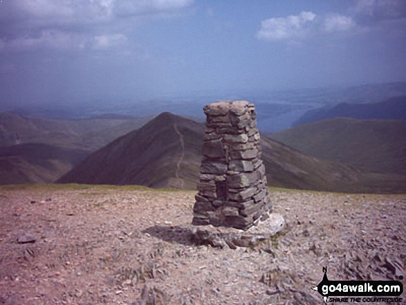 The summit of Helvellyn in The Eastern Fells area of The Lake District
Photo: William Ringwood
# Whether you print a copy or download it to your phone, this Peak Baggers' Map will prove incredibly useful if you want to know what's what when you are up in the mountains and cannot get a phone signal.
Is there a Mountain, Peak, Top or Hill missing from the above google map or list?


