UK Postcode DL6 - The 30 nearest easy-to-follow, circular walk route maps to you
The thirty nearest easy-to-follow, circular walk route maps to you in UK Postcode DL6 in Walk Grade Order
The UK cities, towns and villages in North Yorkshire, England that have DL6 in their UK Postcode include:
• Appleton Wiske • Brompton • Cleveland Tontine • Deighton • East Harlsey • East Rounton • Ellerbeck • Great Smeaton • High Entercommon • Hornby • Ingleby Arncliffe • Ingleby Cross • Kirby Sigston • Low Entercommon • Northallerton • Oaktree Hill • Osmotherley • Potto • Swainby • Thimbleby • Thornton-le-Beans • Welbury • West Rounton • Whorlton •
Not familiar with the area around DL6?
See these 30 nearest walks to UK Postcode DL6 on a google map
   |
Vital Statistics:
| Length: | 5 miles (8 km) |
| Ascent: | 689ft (210m) |
| Time: | 2½ hrs |
| Grade: |  |
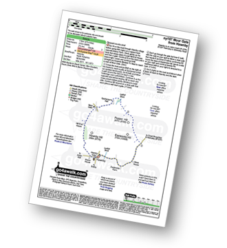
Route Summary:
Hawnby - Hill End House - Moor Gate - Sportsman's Hall - Ladhill Beck - Pepper Hill - Easterside Hill - Wass House - Easterside Farm - Ladhill Beck - Hawnby
|
Vital Statistics:
| Length: | 6.25 miles (10 km) |
| Ascent: | 1,355ft (413m) |
| Time: | 3.75hrs |
| Grade: |  |
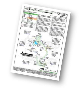
Route Summary:
Kilburn White Horse - Hoodhill Feld Plantation - Hood Hill Plantation - Hood Grange - Kennycow - High Cleavers Farm - Gormire Rigg - Gormire Lake - Southwoods Lodge - Garbutt Wood - The Cleveland Way - Whitestone Cliff - White Mare Crag - Great Relief Pot - Cliff Plantation - Sutton Brow - Sutton Bank - Knowlson's Drop - Roulston Scar - Ivy Scar - Kilburn White Horse
|
Vital Statistics:
| Length: | 6.5 miles (10.5 km) |
| Ascent: | 932ft (284m) |
| Time: | 3.25hrs |
| Grade: | |
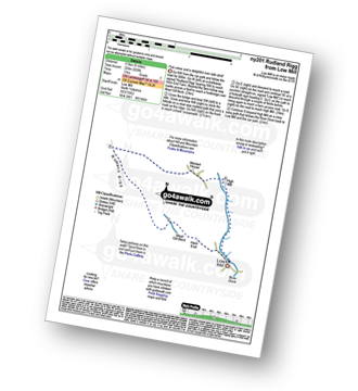
Route Summary:
Low Mill - Horn End Farm - Crow Wood - West Gill Beck - Westside Road (Track) - West Gill Head - Rudland Rigg - Dickon Howe - Monket House Bank (Track) - Monket House - Thorn Wath Bridge - Church Houses - High Mill - River Dove - Ferndale Nature Reserve - Low Mill
|
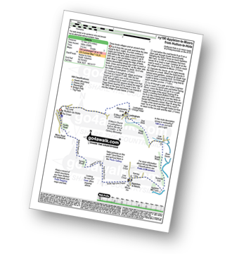
Vital Statistics:
| Length: | 12.75 miles (20.5 km) |
| Ascent: | 1,056ft (322m) |
| Time: | 5.75hrs |
| Grade: |  |

Route Summary:
Hutton-le-Hole - Lodge Road - Wheat Lund - Hutton Ridge - High Snapes - Loskey Beck - Loskey Ridge - Ana Cross - Spaunton Moor - Spring Heads Turn - Barker Slack - Lastingham Ridge - Lastingham - St Chad's Well - St Cedd's Well - Ings beck - Hagg Wood - Lower Askew - Birk Head - Scarth Wood - Tenterhill End - Appleton Mill Farm - The Tabular Hills Walk - Hamley Lane - Appleton-le-Moors - South Ings Lane (Track) - Ings Balk (Track) - Lingmoor Lane (Track) - Spring Wood - Bottom Fields Lane - Austin Head - Hutton-le-Hole
|
Vital Statistics:
| Length: | 8.5 miles (13.5 km) |
| Ascent: | 1,089ft (332m) |
| Time: | 4 hrs |
| Grade: | |

Route Summary:
Hutton-le-Hole - Lodge Road - Wheat Lund - Hutton Ridge - High Snapes - Loskey Beck - Loskey Ridge - Ana Cross - Spaunton Moor - Spring Heads Turn - Barker Slack - Lastingham Ridge - Lastingham - St Chad's Well - St Cedd's Well - Ings beck - Hagg Wood - Spaunton - Grange Farm - Austin Head - Hutton-le-Hole
|
Vital Statistics:
| Length: | 4.5 miles (7 km) |
| Ascent: | 623ft (190m) |
| Time: | 2.25hrs |
| Grade: | |

Route Summary:
Hutton-le-Hole - The Lund - Fairy Call Beck - High Cross Plain - Mary Magdalene Well - Lastingham - St Chad's Well - St Cedd's Well - Ings Beck - Hagg Wood - Spaunton - Grange Farm - Austin Head - Hutton-le-Hole
|
Vital Statistics:
| Length: | 8.75 miles (14 km) |
| Ascent: | 590ft (180m) |
| Time: | 3.75hrs |
| Grade: | |
Route Summary:
Hutton-le-Hole - The Lund - Fairy Call Beck - High Cross Plain - Mary Magdalene Well - Lastingham - St Chad's Well - St Cedd's Well - Ings beck - Hagg Wood - Lower Askew - Birk Head - Scarth Wood - Tenterhill End - Appleton Mill Farm - The Tabular Hills Walk - Hamley Lane - Appleton-le-Moors - South Ings Lane (Track) - Ings Balk (Track) - Lingmoor Lane (Track) - Spring Wood - Bottom Fields Lane - Austin Head - Hutton-le-Hole
|
Vital Statistics:
| Length: | 17.5 miles (28 km) |
| Ascent: | 1,591ft (485m) |
| Time: | 7.75hrs |
| Grade: |  |
Route Summary:
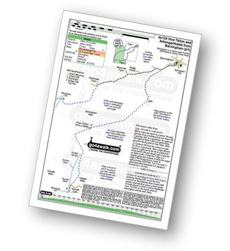
Barningham - Birk Hills Farm - Brown Hill - Cathaw Stoop - Carter Allotment - Badger Way - Badger Way Stoop - How Tallon - How Tallon Gate - How Tallon Ridge - High Moor - Arndale Springs - Frankinshaw How - Holgate Moor - Arndale hole - Kexwith Beck - Kexwith Farm - Moresdale Gill - Moresdale - Moresdale Road - Fair Seat Hill - Moresdale Ridge - Stony Man (St Andrew's Cross) - Booze Moor - Low Moor - Windeg Vein - Little Windeg - Dry Gill Bottom - Shaw Farm - Stang Side - Stang House - Freestone Ridge - Stang Top - Hope Moor - The Stang - Woodcote Gill - Black Hill Gate - Haythwaite Farm - Moorcock Farm - Bragg House - Barningham
|
Vital Statistics:
| Length: | 9 miles (14.5 km) |
| Ascent: | 1,674ft (510m) |
| Time: | 5 hrs |
| Grade: | |

Route Summary:
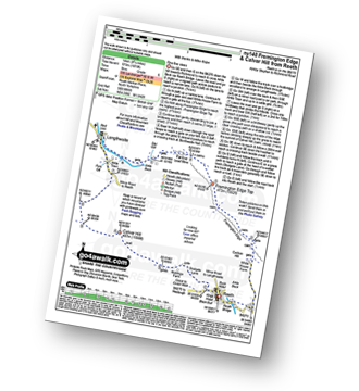
Reeth - Wainwright's Coast to Coast Walk - Arkle Beck - High Fremington - White House Farm - Fremington Edge - Fremington Edge Top - Fell End Lead Mine - Storthwaite Hall - Arkengarthdale - Langthwaite - Castle Farm House - Cuckoo Hill - The Herriot Way - Reeth
|
Vital Statistics:
| Length: | 12.75 miles (20.5 km) |
| Ascent: | 1,935ft (590m) |
| Time: | 6½ hrs |
| Grade: |  |

Route Summary:
Reeth - River Swale - Harkerside Place Farm - Harker Mires - The Herriot Way - Low Harker Hill - High Harker Hill - Blue Hill - Beldow Hill - Green Hill Ends - Whitaside Moor - ashpot Gutters - Apedale Road (Track) Apedale - Dent's House - Greets Hill - How Hill - Grinton Lodge - The Herriot Way - Grinton - Arkle Beck - Reeth
|
Vital Statistics:
| Length: | 8.75 miles (14 km) |
| Ascent: | 1,870ft (570m) |
| Time: | 5 hrs |
| Grade: | |
Route Summary:
Reeth - Arkle Beck - High Fremington - White House Farm - Fremington Edge - Fremington Edge Top - Fell End Lead Mine - Storthwaite Hall - Arkengarthdale - Langthwaite - Arken Town - Calver Hill - Riddings Farm - Skelgate Lane - Wainwright's Coast to Coast Walk - The Herriot Way - Reeth
|
Vital Statistics:
| Length: | 7 miles (11 km) |
| Ascent: | 1,674ft (411m) |
| Time: | 4 hrs |
| Grade: | |

Route Summary:
Reeth - Wainwright's Coast to Coast Walk - Arkle Beck - High Fremington - White House Farm - Fremington Edge - Fremington Edge Top - Fell End Lead Mine - Storthwaite Hall - Arkengarthdale - Castle Farm House - Cuckoo Hill - The Herriot Way - Reeth
|
Vital Statistics:
| Length: | 6.5 miles (10.5 km) |
| Ascent: | 647ft (197m) |
| Time: | 3 hrs |
| Grade: | |
Route Summary:
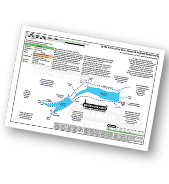
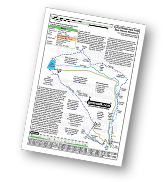
Nidderdale - Scar House Reservoir - River Nidd - Nidderdale - Carle Fell Road (Track) - Stand Sike - Wench Gill - Angram Reservoir - Pudding Hill - West House Pasture - Angram Low Pasture - Stone Beck - Scar House Reservoir - Nidderdale
|
Vital Statistics:
| Length: | 4.75 miles (7.5 km) |
| Ascent: | 571ft (174m) |
| Time: | 2.25hrs |
| Grade: | |
Route Summary:
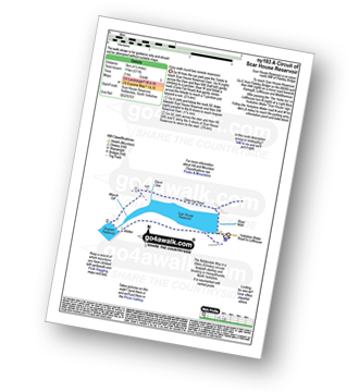
Nidderdale - Scar House Reservoir - River Nidd - Nidderdale - Carle Fell Road (Track) - Stand Sike - Wench Gill - Angram Reservoir - Scar House Reservoir - Nidderdale
|
Vital Statistics:
| Length: | 10.75 miles (17 km) |
| Ascent: | 2,022ft (616m) |
| Time: | 6 hrs |
| Grade: | |
Route Summary:
Nidderdale - Scar House Reservoir - The Nidderdale Way - In Moor Lane - Rain Stang - Middlesmoor - How Stean Beck - How Stean Gorge - River Nidd - Lofthouse - Thorpe Lane - Thorp Farm - Dry Wrath Ford - Limley Farm - Thwaite House - Bracken Ridge - Summerstone Lodge - The Edge - Nidd Cottage - New Houses Edge Farm - Turnacar - Thornet Barn - Twizling Gill - Woo Gill - Carl Fell Road (Track) - River Nidd - Scar House Reservoir - Nidderdale
Not familiar with the area around DL6?
See these 30 nearest walks to UK Postcode DL6 on a google map
|
Vital Statistics:
| Length: | 11.5 miles (18.5 km) |
| Ascent: | 1,913ft (583m) |
| Time: | 6.25hrs |
| Grade: | |

Route Summary:
Nidderdale - Scar House Reservoir - Nidderdale - River Nidd - Carle Fell Road - Wench Gill - Little Whernside - Nidd Head - Black Dike Hole - Blackfell Top - Great Whernside - Stone Beck - Angram Reservoir - Scar House Reservoir - Nidderdale
|
Vital Statistics:
| Length: | 3 miles (4.5 km) |
| Ascent: | 367ft (112m) |
| Time: | 1½ hrs |
| Grade: |  |
Route Summary:
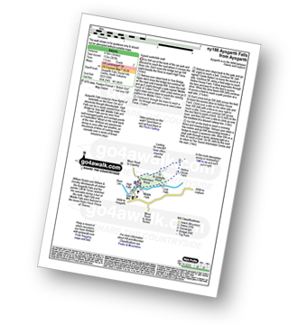
Aysgarth - Aysgarth Falls - High Force - The Herriot Way - Aysgarth Falls - Middle Force - Aysgarth Falls - Low Force - St Josephs Wood - Freeholders' Wood - Aysgarth
|
Vital Statistics:
| Length: | 4.5 miles (7 km) |
| Ascent: | 870ft (265m) |
| Time: | 2½ hrs |
| Grade: | |
Route Summary:
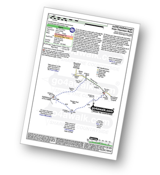
Thornton Rust - Thornton Rust Moor - Addlebrough - Swallow Hole - Worton Scar - Thornton Scar - Thornton Rust
|
Vital Statistics:
| Length: | 5.25 miles (8.5 km) |
| Ascent: | 380ft (116m) |
| Time: | 2.25hrs |
| Grade: | |
Route Summary:
Thornton-le-Dale - Hagg House - Howl Dale Wood - Howl Dale - Orchan Dale - Pexton Moor Plantation - Kirkdale Slack - Ellerburn - Thornton-le-Dale
|
Vital Statistics:
| Length: | 9.75 miles (15.5 km) |
| Ascent: | 1,388ft (423m) |
| Time: | 5 hrs |
| Grade: | |
Route Summary:
Askrigg - Askrigg Bottoms - The River Ure - Wensleysdale - Worton Bridge - Worton - Cubeck - Carpley Green Road - Worton Pasture - Carpley Green Farm - Addlebrough - Thornton Rust Moor - Thornton Rust - River Ure - Wensleydale - Nappa Mill Farm - Askrigg
|
Vital Statistics:
| Length: | 7.75 miles (12.5 km) |
| Ascent: | 1,214ft (370m) |
| Time: | 4.25hrs |
| Grade: | |

Route Summary:
Askrigg - Askrigg Bottoms - The River Ure - Wensleysdale - Worton Bridge - Worton - Cubeck - Carpley Green Road - Worton Pasture - Carpley Green Farm - Addlebrough - Swallow Hole - Worton Scar - Worton - Wensleydale - Askrigg Bottoms - Askrigg
|
Vital Statistics:
| Length: | 5 miles (8 km) |
| Ascent: | 502ft (153m) |
| Time: | 2½ hrs |
| Grade: | |

Route Summary:
Askrigg - Askrigg Bottoms - The River Ure - Wensleysdale - Worton Bridge - Worton - Worton Scar - Thornton Scar - Thornton Rust - River Ure - Wensleydale - Nappa Mill Farm - Askrigg
|
Vital Statistics:
| Length: | 7 miles (11 km) |
| Ascent: | 1,345ft (410m) |
| Time: | 3.75hrs |
| Grade: | |

Route Summary:
Muker - Kisdon - Hooker Mill Scar - Swallow Hole Farm - Keld - The Herriot Way - The Pennine Way - The River Swale - Wainwright's Coast to Coast Walk - Kisdon Force - East Gill Force - Crackpot Hall - Swinner Gill - Arngill Wood - Swaledale - Ramps Holme Bridge - Muker
|
Vital Statistics:
| Length: | 11 miles (17.5 km) |
| Ascent: | 1,181ft (360m) |
| Time: | 5.25hrs |
| Grade: | |
Route Summary:
Yarnbury - Grassington Lead Mines - Duke's New Road (Track) - Hebden Beck - Cupola Corner - Deep Cut - Grassington Moor - Rather Standard Side - Sleet Moor - Rather Standard End - Henstone Band - Meugher Dike - Meugher Drive - Meugher - Friar Hood - Sandy Gate - Sandy Gate Pike Shelter - Mossdale - Mossdale Shooting Lodge - Mossdale Beck - Mossdale Scar - Bycliffe Road (Track) - Bycliffe - Kelber - Seeds Hill - Green Hill Pasture - Back Pasture - Downs Pasture - High Barn (ruin) - New Pasture Edge - Yarnbury
|
Vital Statistics:
| Length: | 12.5 miles (20 km) |
| Ascent: | 2,099ft (640m) |
| Time: | 6.75hrs |
| Grade: | |
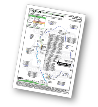
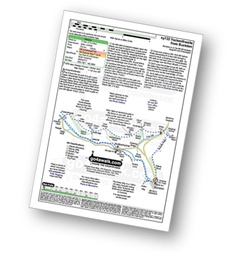
Route Summary:
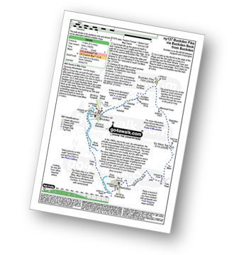
Buckden - Rakes Wood - Buckden Rake - Cray Gill - Cray - Crook Gill - Todd's Wood - Scar House - Strans Gill - Strans Wood - Yockenthwaite - Horse Head (Horse Head Moor) - Sugar Loaf (Horse Head Moor) - High Combe Stoop - Birks Fell - Birks Tarn - Firth Fell - Redmire Farm - Buckden
|
Vital Statistics:
| Length: | 9 miles (14.5 km) |
| Ascent: | 1,766ft (538m) |
| Time: | 5 hrs |
| Grade: | |
Route Summary:
Buckden - Rakes Wood - Cow Close - Buckden Pike - Fox Memorial - Starbotton Fell - Tor Mere Top - Cam Head - Starbotton Cam Road - Starbotton - The Dales Way - River Wharfe - Wharfedale - Buckden
|
Vital Statistics:
| Length: | 9.5 miles (15 km) |
| Ascent: | 1,906ft (581m) |
| Time: | 5½ hrs |
| Grade: | |

Route Summary:
Buckden - Rakes Wood - Buckden Rake - Cray Gill - Cray - Crook Gill - Todd's Wood - Scar House - Strans Gill - Strans Wood - Yockenthwaite Moor - Yockenthwaite - The Dales Way - Hubberholme - The River Wharfe - Wharfedale - Buckden
|
Vital Statistics:
| Length: | 8.5 miles (13.5 km) |
| Ascent: | 1,802ft (549m) |
| Time: | 4.75hrs |
| Grade: | |
Route Summary:
Buckden - Buckden Beck - Buckden Lead Mine - Buckden Pike - Fox Memorial - Starbotton Fell - Tor Mere Top - Cam Head - Starbotton Cam Road - Starbotton - The Dales Way - River Wharfe - Wharfedale - Buckden
|
Vital Statistics:
| Length: | 7.25 miles (11.5 km) |
| Ascent: | 991ft (302m) |
| Time: | 3½ hrs |
| Grade: | |
Route Summary:
Buckden - Rakes Wood - Buckden Rake - Cray Gill - Cray - Crook Gill - Todd's Wood - Scar House - Strans Gill - Strans Wood - Yockenthwaite - The Dales Way - Hubberholme - The River Wharfe - Wharfedale - Buckden
|
Vital Statistics:
| Length: | 10 miles (16 km) |
| Ascent: | 1,771ft (540m) |
| Time: | 5½ hrs |
| Grade: | |
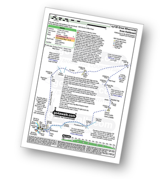
Route Summary:
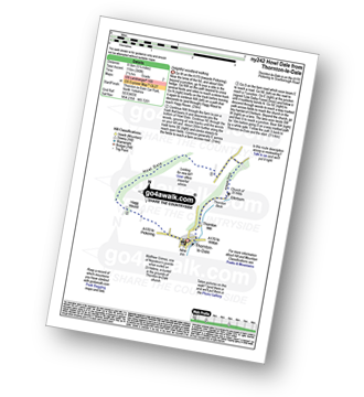
Kettlewell - Dowber Gill Beck - Providence Pot - Hag Dyke (hostel) - Great Whernside - Black Hole Dike - Nidd Head - Little Hunters Sleet - Tor Dyke - Starbotton Road - Top Mere Road - Kettlewell
Not familiar with the area around DL6?
See these 30 nearest walks to UK Postcode DL6 on a google map


