   |
Vital Statistics:
| Length: | 17½mls (28km) |
| Ascent: | 1,591ft (485m) |
| Time: | 7¾hrs |
| Grade: |  |
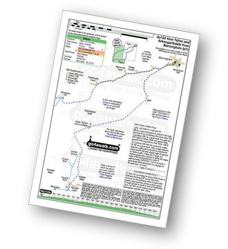
Route outline for walk du124:
Barningham - Birk Hills Farm - Brown Hill - Cathaw Stoop - Carter Allotment - Badger Way - Badger Way Stoop - How Tallon - How Tallon Gate - How Tallon Ridge - High Moor - Arndale Springs - Frankinshaw How - Holgate Moor - Arndale hole - Kexwith Beck - Kexwith Farm - Moresdale Gill - Moresdale - Moresdale Road - Fair Seat Hill - Moresdale Ridge - Stony Man (St Andrew's Cross) - Booze Moor - Low Moor - Windeg Vein - Little Windeg - Dry Gill Bottom - Shaw Farm - Stang Side - Stang House - Freestone Ridge - Stang Top - Hope Moor - The Stang - Woodcote Gill - Black Hill Gate - Haythwaite Farm - Moorcock Farm - Bragg House - Barningham
You can find this walk and other nearby walks on these unique free-to-access Interactive Walk Planning Maps:
1:25,000 scale OS Explorer Maps (orange/yellow covers):
1:50,000 scale OS Landranger Map (pink/magenta covers):
Send us your photographs and pictures from your walks and hikes
We would love to see your photographs and pictures from walk du124 How Tallon and The Stang from Barningham. Send them in to us as email attachments (configured for any computer) along with your name and where the picture was taken to:
and we shall do our best to publish them.
(Guide Resolution = 300dpi. At least = 660 pixels (wide) x 440 pixels (high).)

You can also submit photos from walk du124 How Tallon and The Stang from Barningham via our Facebook Page.
NB. Please indicate where each photo was taken.


