Twenty-four easy to follow walks from Braithwaite Bridges Campsite, Braithwaite, The Lake District, Cumbria, England
To reach Braithwaite Bridges Campsite, Braithwaite, in-car SatNav users should select the Latitude/Longitude (Lat Lon) screen and enter:
Lat = N54.60214 and Lon = W3.18763 or postcode: CA12 5TD
Not familiar with this campsite?
Twenty-four easy to follow walks from Braithwaite Bridges Campsite, Braithwaite, The Lake District, Cumbria, England
Scroll down the list of walks below & click on each walk title (in blue) to locate it on the map above.
   |
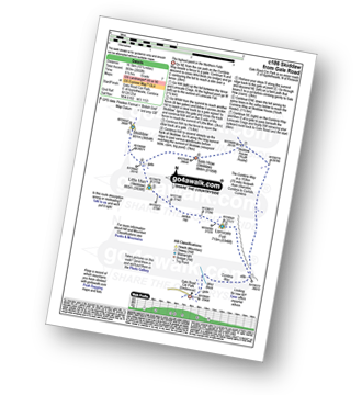
Vital Statistics:
| Length: | 2 miles (3 km) |
| Ascent: | 413ft (126m) |
| Time: | 1 hrs |
| Grade: |  |

Route Summary:
Keswick - Gale Road (Underscar) - The Cumbria Way - Latrigg - Gale Road (Underscar) - Nr Keswick.
|
Vital Statistics:
| Length: | 4.5 miles (7 km) |
| Ascent: | 361ft (110m) |
| Time: | 2 hrs |
| Grade: |  |

Route Summary:
Keswick - Keswick Station - Former Keswick Railway Line - A591 - Chestnut Hill - Castlerigg Stone Circle - High Nest Farm - Castlerigg - Brockle Beck - Springs Farm - Keswick
|
Vital Statistics:
| Length: | 9 miles (14 km) |
| Ascent: | 131ft (40m) |
| Time: | 3.25hrs |
| Grade: | |
Route Summary:
Keswick - The Cumbria Way - The Allerdale Ramble - Portinscale - Nichol End - Derwent Water - Hawes End - Brandlehow Point - Park Neb - Strutta Wood - Calfclose Bay - Stable Hills - Friar's Crag - Keswick
|
Vital Statistics:
| Length: | 5 miles (8 km) |
| Ascent: | 649ft (198m) |
| Time: | 2.75hrs |
| Grade: |  |

Route Summary:
Hawes End - Gutherscale - Derwent Water - Skelgill Farm - Yewthwaite Gill - Little Town - Parrocks Gill - Goldscope Lead Mine - Newlands Beck - Low Snab Farm - Newlands Church - Newlands Valley - Rigg Beck - Rowling End Farm - Newlands Beck - Ghyll Bank - Skelgill Farm - Gutherscale - Hawes End
|
Vital Statistics:
| Length: | 6.25 miles (10 km) |
| Ascent: | 1,230ft (375m) |
| Time: | 3½ hrs |
| Grade: |  |

Route Summary:
Keswick - Friar's Crag - Calfclose Bay - Barrow Bay - Derwent Water - Ashness Bridge - Walla Crag - Rakefoot - Castlerigg - Brockle Beck - Spring Farm - Keswick
|
Vital Statistics:
| Length: | 6.25 miles (10 km) |
| Ascent: | 941ft (287m) |
| Time: | 3 hrs |
| Grade: | |

|
Vital Statistics:
| Length: | 3.75 miles (6 km) |
| Ascent: | 1,628ft (496m) |
| Time: | 3 hrs |
| Grade: | |

Route Summary:
Keswick - Derwent Water Launch - Nichol End Pier - Hawes End Pier - Newlands Valley - Woodford's Path - Cat Bells (Catbells) - Hawes End Pier - Derwent Water Launch - Keswick
|
Vital Statistics:
| Length: | 6 miles (9.5 km) |
| Ascent: | 900ft (274m) |
| Time: | 3.24hrs |
| Grade: | |
Route Summary:
Keswick - Friar's Crag - Borrowdale Road - Spring Farm - Brockle Beck - Castlerigg - High Nest Farm - Castlerigg Stone Circle - Brigham - River Greta - Keswick
|
Vital Statistics:
| Length: | 9.5 miles (15 km) |
| Ascent: | 1,250ft (381m) |
| Time: | 4.75hrs |
| Grade: |  |

Route Summary:
Keswick - Friar's Crag - Borrowdale Road - Spring Farm - Brockle Beck - Castlerigg - High Nest Farm - Castlerigg Stone Circle - Naddle Bridge - Threlkeld - River Greta - Keswick
|
Vital Statistics:
| Length: | 8.25 miles (13 km) |
| Ascent: | 2,512ft (766m) |
| Time: | 5½ hrs |
| Grade: |  |

Route Summary:
Hawes End - Derwent Water - Newlands Valley - Skelgill Bank - Woodford's Path - Cat Bells (Catbells) - Maiden Moor - High Spy (North Top) - High Spy - Dalehead Tarn - Newlands Valley - Newlands Church - Little Town - Hawes End
|
Vital Statistics:
| Length: | 9.5 miles (15 km) |
| Ascent: | 2,257ft (688m) |
| Time: | 5½ hrs |
| Grade: | |
Route Summary:
Keswick - Derwent Water - Friar's Crag - Calfclose Bay - Barrow Bay - Derwent Water - Ashness Bridge - High Seat (Ashness Fell) - Bleaberry Fell - Walla Crag - Rakefoot - Castlerigg - Keswick
|
Vital Statistics:
| Length: | 7.25 miles (11.5 km) |
| Ascent: | 3,013ft (918m) |
| Time: | 5.75hrs |
| Grade: | |
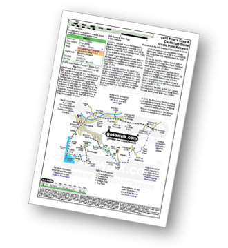
Route Summary:
Braithwaite - Barrow (Newlands) - Stile End - Low Moss - Outerside - High Moss - Scar Crags - Causey Pike - Sleet Hause - Rowling End - Stoneycroft - Braithwaite
|
Vital Statistics:
| Length: | 10.25 miles (16.5 km) |
| Ascent: | 3,585ft (1,093m) |
| Time: | 7½ hrs |
| Grade: |  |

Route Summary:
Hawes End - Derwent Water - Skelgill Bank - Woodford's Path - Cat Bells (Catbells) - Maiden Moor - High Spy (North Top) - High Spy - Dalehead Tarn - Dale Head (Newlands) - Hindscarth - High Crags - Scope End - Low Snab Farm - Newlands Church - Little Town - Newlands Valley - Hawes End - Derwent Water.
|
Vital Statistics:
| Length: | 8.5 miles (13.5 km) |
| Ascent: | 3,840ft (1,170m) |
| Time: | 7 hrs |
| Grade: | |

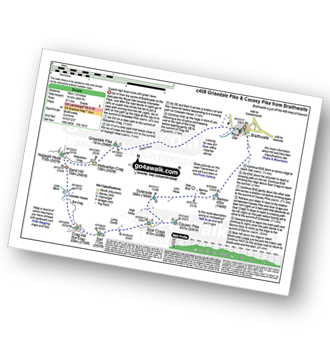
Route Summary:
Braithwaite - Sleet How - Grisedale Pike - Hobcarton Crag - Hopegill Head - Sand Hill - Coldale Hause - Eel Crag - Crag Hill (Eel Crag) - Sail (Derwent Fells) - Long Comb - High Moss - Low Moss - Barrow Door - Braithwaite
|
Vital Statistics:
| Length: | 10.25 miles (16.5 km) |
| Ascent: | 2,850ft (869m) |
| Time: | 6½ hrs |
| Grade: | |
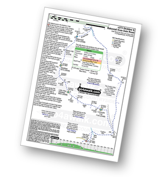
Route Summary:
Keswick - Gale Road (Underscar) Nr Keswick - Lonscale Fell - Jenkin Hill - Little Man (Skiddaw) - Skiddaw - Sale How (Skiddaw) - Skiddaw House - Gale Road (Underscar) Nr Keswick.
|
Vital Statistics:
| Length: | 8.25 miles (13 km) |
| Ascent: | 3,306ft (1,008m) |
| Time: | 6.25hrs |
| Grade: | |
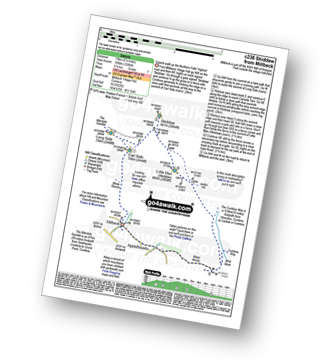
Route Summary:
Keswick - Millbeck - The Allerdale Ramble - Doups - White Stones - Carl Side - Longside Edge - Long Side - Skiddaw - Little Man (Skiddaw) - The Cumbria Way - Applethwaite - The Allerdale Ramble - Millbeck - Nr Keswick.
|
Vital Statistics:
| Length: | 11.5 miles (18.5 km) |
| Ascent: | 3,214ft (980m) |
| Time: | 7½ hrs |
| Grade: | |
Route Summary:
Keswick - Gale Road - Lonscale Fell - Jenkin Hill - Little Man (Skiddaw) - Skiddaw - Bakestall - Birkett Edge - Whitewater Dash - Back O' Skiddaw - The Cumbria Way - Skiddaw House - Gale Road (Underscar) Nr Keswick.
|
Vital Statistics:
| Length: | 9.75 miles (15.5 km) |
| Ascent: | 3,529ft (1,076m) |
| Time: | 7 hrs |
| Grade: | |

Route Summary:
Keswick - Millbeck - The Allerdale Ramble - Doups - White Stones - Carl Side - Longside Edge - Long Side - Skiddaw - Little Man (Skiddaw) - Jenkin Hill - Lonscale Fell - Lonscale Crags - The Cumbria Way - Applethwaite - The Allerdale Ramble - Millbeck - Nr Keswick.
|
Vital Statistics:
| Length: | 10 miles (16 km) |
| Ascent: | 3,349ft (1,082m) |
| Time: | 7.25hrs |
| Grade: | |

Route Summary:
Hawes End - Derwent Water - Skelgill Bank - Woodford's Path - Cat Bells (Catbells) - Maiden Moor - Narrow Moor - High Spy (North Top) - High Spy - Dale Head Tarn - Rigghead Quarries - The Allerdale Ramble - Castle Crag - River Derwent - Yewdale Knott - Manesty - Manesty Band - Hawes End - Derwent Water.
|
Vital Statistics:
| Length: | 12 miles (19 km) |
| Ascent: | 4,152ft (1,266m) |
| Time: | 8½ hrs |
| Grade: |  |

Route Summary:
Hawes End - Derwent Water - Skelgill Bank - Woodford's Path - Cat Bells (Catbells) - Maiden Moor - High Spy (North Top) - High Spy - Dale Head Tarn - Dale Head (Newlands) - Hindscarth Edge - Hindscarth - Littledale Edge - Robinson - High Snab Bank - Newlands Church - Little Town - Hawes End - Derwent Water.
|
Vital Statistics:
| Length: | 10 miles (16 km) |
| Ascent: | 4,641ft (1,414m) |
| Time: | 8½ hrs |
| Grade: | |
Route Summary:
Braithwaite - Sleet How - Grisedale Pike - Hobcarton Crag - Hopegill Head - Sand Hill - Coledale Hause - Crag Hill (Eel Crag) - Sail (Derwent Fells) - Scar Crags - Causey Pike - Outerside - Stile End - Barrow (Newlands) - Braithwaite
|
Vital Statistics:
| Length: | 12 miles (19 km) |
| Ascent: | 5,261ft (1,603m) |
| Time: | 9.75hrs |
| Grade: |  |

Route Summary:
Braithwaite - Sleet How - Grisedale Pike - Hobcarton Crag - Hopegill Head - Sand Hill - Coledale Hause - Grasmoor - Wandope - Crag Hill (Eel Crag) - Sail (Derwent Fells) - Scar Crags - Causey Pike - Outerside - Stile End - Barrow (Newlands) - Braithwaite
|
Vital Statistics:
| Length: | 15.25 miles (24.5 km) |
| Ascent: | 5,458ft (1,663m) |
| Time: | 11 hrs |
| Grade: | |

Route Summary:
Keswick - Millbeck - The Allerdale Ramble - Doups - Dodd (Skiddaw) - White Stones (Skiddaw) - Carl Side - Longside Edge - Long Side - Ullock Pike - Carlside Tarn - Skiddaw - Blake Hill - Bakestall - Little Man (Skiddaw) - Jenkin Hill - Lonscale Fell - Lonscale Crags - The Cumbria Way - Latrigg - Applethwaite - The Allerdale Ramble - Millbeck - Nr Keswick.
|
Vital Statistics:
| Length: | 14.5 miles (23 km) |
| Ascent: | 5,409ft (1,648m) |
| Time: | 11 hrs |
| Grade: | |

Route Summary:
Hawes End - Derwent Water - Skelgill Bank - Woodford's Path - Cat Bells (Catbells) - Maiden Moor - High Spy (North Top) - High Spy - Dalehead Tarn - Dale Head (Newlands) - Hindscarth - Littledale Edge - Robinson - High Snockrigg - Moss Force - Newlands Hause - Knott Rigg - Ard Crags - Birkrigg - Keskerdale Beck - Newlands Church - Newlands Beck - Little Town - Skelgill Farm - Hawes End Derwent Water.


