
![]()
Knott Rigg
556m (1825ft)
The North Western Fells, The Lake District, Cumbria, England

Not familiar with this top?
   |
|---|
Vital Statistics:
| Length: | 6ml (9.5km) |
|---|---|
| Ascent: | 1,894ft (577m) |
| Time: | 4 hrs |
| Grade: |  (Moderate) (Moderate) |

Route Summary:
Little Town - Newlands Church - Keskerdale Farm - Knott Rigg - Ard Crags - Rigg Beck - Birkrigg - Gillbrow - Little Town
|
|---|
Vital Statistics:
| Length: | 14.5ml (23km) |
|---|---|
| Ascent: | 5,409ft (1,648m) |
| Time: | 11 hrs |
| Grade: |  (Very Hard) (Very Hard) |

Route Summary:
Hawes End - Derwent Water - Skelgill Bank - Woodford's Path - Cat Bells (Catbells) - Maiden Moor - High Spy (North Top) - High Spy - Dalehead Tarn - Dale Head (Newlands) - Hindscarth - Littledale Edge - Robinson - High Snockrigg - Moss Force - Newlands Hause - Knott Rigg - Ard Crags - Birkrigg - Keskerdale Beck - Newlands Church - Newlands Beck - Little Town - Skelgill Farm - Hawes End Derwent Water.
See Knott Rigg and the surrounding tops on our free-to-access 'Google Style' Peak Bagging Maps:
The North Western Fells of The Lake District National Park
Less data - quicker to download
The Whole of The Lake District National Park
More data - might take a little longer to download
See Knott Rigg and the surrounding tops on our downloadable Peak Bagging Maps in PDF format:

NB: Whether you print off a copy or download it to your phone, these PDF Peak Baggers' Maps might prove incredibly useful when your are up there on the tops and you cannot get a phone signal.
*This version is marked with the walk routes you need to follow to Walk all 214 Wainwrights in just 59 walks.
You can find Knott Rigg & all the walks that climb it on these unique free-to-access Interactive Walk Planning Maps:
1:25,000 scale OS Explorer Map (orange/yellow covers):
1:50,000 scale OS Landranger Maps (pink/magenta covers):
 Fellow go4awalkers who have already walked, climbed, summited & bagged Knott Rigg
Neil Walker walked up Knott Rigg on August 21st, 2025 [from/via/route] Rowling End Farm [with] Emma [weather] Cloudy - Out-and-back walk from Rowling End. Tough slog up Ard Crags from Ill rigg, then easy walking on the plateau to Knot Rigg
James Hughes climbed it on August 2nd, 2025 [from/via/route] c345 Knott Rigg & Ard Crags from Little Town [weather] Warm, sunny spells, breezy on tops. - Pleasant afternoon stroll from carpark near Newlands Church (honesty payment). Easy walk up road to cross fields to road near Keskerdale Farm. Not clear where to take path up to Knott Rigg, but farmer assisted. Through gate opposite farm, make for tree & then climb over gate at top (to keep sheep in). Path is clear from there cutting up side of hill to ascend to Knott Rigg. Really easy over top to Ard Crags. Then steepish but easy descent off top. Clear path bears left to path at base of Causey Pike. Took a less distinct path due to following instructions which ended up on this path anyhow. Path joins road at bridge & then returned on road back to Newlands Church. Easy. Pint of Landlord at Swinside Inn. Generally underwhelmed.
Caroline Winter bagged it on March 26th, 2025 [from/via/route] Quarry CP, Rigg beck, Ard crags, Ard top, Knott Rigg, Newlands Hause, road back [with] Solo [weather] Warm excellent views - Excellent for fell top spotting from Blencathra & Dodds, to Grassmoor & beyond.
Nick Tippins hiked Knott Rigg on March 24th, 2025 [from/via/route] c345: Knott Rigg & Ard Crags from Little Town [with] Fran
Martin Hartshorne summited on March 21st, 2025 [from/via/route] Rannerdale parking area [with] finley [weather] Started warm & sunny, then strong winds clouded over quite cold
To add (or remove) your name and experiences on this page - Log On and edit your Personal Mountain Bagging Record
. . . [see more walk reports]
More Photographs & Pictures of views from, on or of Knott Rigg
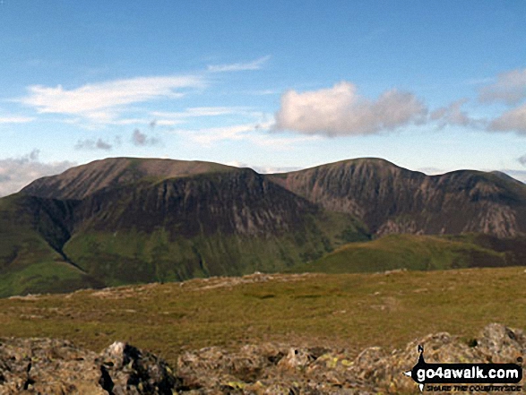
Grasmoor (back), Whiteless Pike, Wandope and Crag Hill (Eel Crag), Sail (mid distance) and Knott Rigg (foreground right) from Robinson

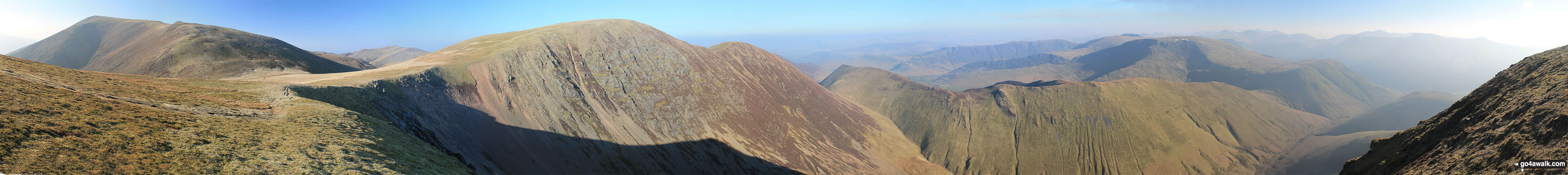
Grasmoor, Crag Hill (Eel Crag), Sail, Ard Crags and Knott Rigg from the summit of Wandope

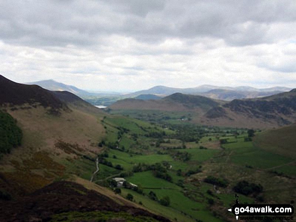
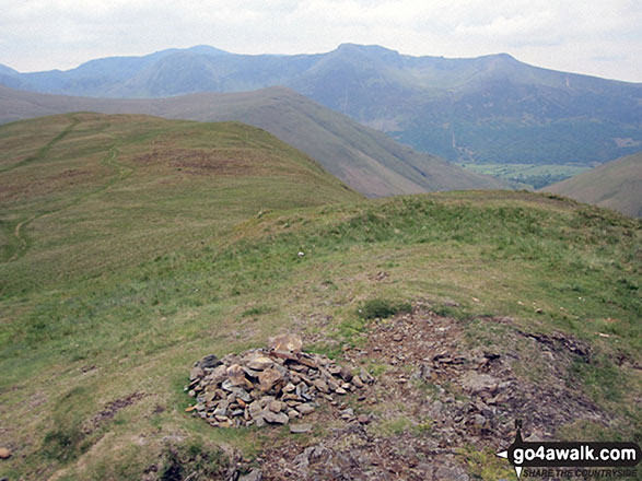
Knott Rigg (foreground left), Buttermere (just poking out) with Red Pike (Buttermere) beyond and Whitelees Pike & Wandope (centre right) from Ard Crags

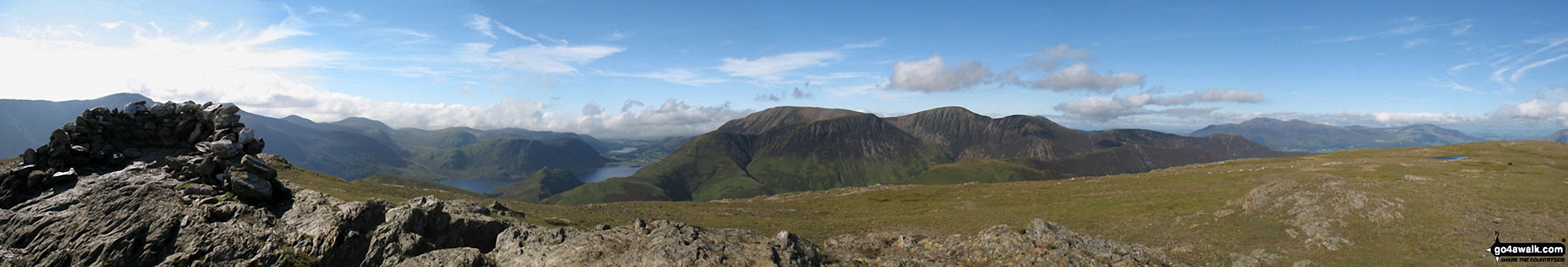
The summit shelter, Mellbreak, Rannerdale Knotts, Buttermere, Grasmoor, Whiteless Pike, Wandope, Crag Hill (Eel Crag), Sail and Knott Rigg from the summit of Robinson
. . . see all 10 walk photographs & pictures of views from, on or of Knott Rigg
Send us your photographs and pictures on, of, or from Knott Rigg
If you would like to add your walk photographs and pictures to this page, please send them as email attachments (configured for any computer) along with your name to:
and we shall do our best to publish them.
(Guide Resolution = 300dpi. At least = 660pixels (wide) x 440 pixels (high).)

You can also submit photos via our Facebook Page.
NB. Please indicate where each photo was taken and whether you wish us to credit your photos with a Username or your First Name/Last Name.


