UK Postcode LD3 - The 30 nearest easy-to-follow, circular walk route maps to you
The thirty nearest easy-to-follow, circular walk route maps to you in UK Postcode LD3 in Walk Grade Order
The UK cities, towns and villages in Powys, Wales that have LD3 in their UK Postcode include:
• Abercynafon • Aberyscir • Battle • Blaen Dyryn • Boughrood • Brecon • Bronllys • Bwlch • Castle Madoc • Cathedine • Cefn Cantref • Cnewr • Cray • Defynnog • Felinfach • Ffrwdgrech • Garthbrengy • Glan Honddu • Halfway • Heol Lly Goden • Heol Senni • Libanus • Llanddew • Llandefaelog Fach • Llandefaelog-tre'r-graig • Llandefalle • Llandeilo'r-Fan • Llanelieu • Llanfaes • Llanfihangel Nant Bran • Llanfihangel-Tal-y-llyn • Llanfilo • Llanfrynach • Llangasty-Talyllyn • Llangorse • Llanhamlach • Llansantffraed • Llanspyddid • Llanstephan • Llanywern • Llechfaen • Llyswen • Llywel • Lower Chapel • Merthyr Cynog • Pencelli • Pengenffordd • Penpont • Pentre-bach • Pentre-Dolau-Honddu • Pentre'r-felin • Pipton • Pont-faen • Pwllgloyw • Scethrog • Sennybridge • Tai'r Bull • Talachddu • Talgarth • Talybont-on-Usk • Talyllyn • Three Cocks • Trallong • Trecastle • Tredomen • Trefecca • Tregoyd • Upper Chapel • Velindre •
Not familiar with the area around LD3?
See these 30 nearest walks to UK Postcode LD3 on a google map
   |
Vital Statistics:
| Length: | 8.5 miles (13.5 km) |
| Ascent: | 2,539ft (774m) |
| Time: | 5.75hrs |
| Grade: |  |
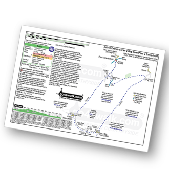
Route Summary:
Pont y Caniedydd - Afon Cynrig - Bailea - Cwm Cynwyn Farm - Bryn Teg - Cribyn - Bwlch ar y Fan - Fan y Big - Cefn Cyff - Nant Cynrig - Cwmcynwyn - Pont y Caniedydd
|
Vital Statistics:
| Length: | 8 miles (12 km) |
| Ascent: | 2,629ft (801m) |
| Time: | 5½ hrs |
| Grade: | |
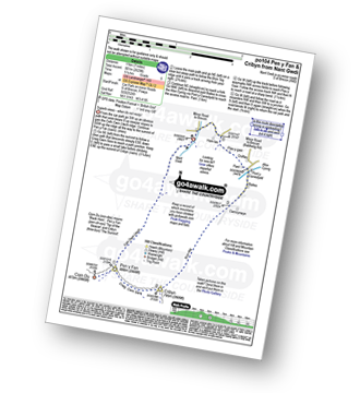
Route Summary:
Nant Gwdi - Cefn Cwm Llwch - Pen y Fan - Corn Du - Pen y Fan - (Penyfan) - Craig Cwm Sere - Cribyn - Bryn-teg - Pant - Plas-y-gaer - Nant Gwdi
|
Vital Statistics:
| Length: | 7.25 miles (11.5 km) |
| Ascent: | 1,526ft (465m) |
| Time: | 4.25hrs |
| Grade: |  |

Route Summary:
LLangors Lake (Llangorse Lake) or Llyn Syfaddan - Llangors - Mynydd Troed - Llangors - LLangors Lake.
|
Vital Statistics:
| Length: | 7 miles (11 km) |
| Ascent: | 2,288ft (697m) |
| Time: | 5 hrs |
| Grade: | |
Route Summary:
Nant Cwm Llwch - Brecon - Llyn Cwm Llwch - Tommy Jones Obelisk - Craig Cwm Llwch - Corn Du - Pen y Fan - (Penyfan) - Cefn Cwm Llwch - Heolfanog - Cil-rhew - Pont Rhydybetws - Nant Cwm Llwch
|
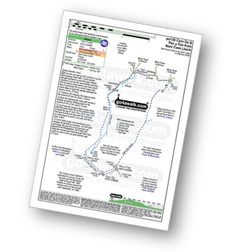
Vital Statistics:
| Length: | 10.5 miles (17 km) |
| Ascent: | 3,256ft (992m) |
| Time: | 7.25hrs |
| Grade: |  |

Route Summary:
Nant Cwm Llwch - Brecon - Llyn Cwm Llwch - Tommy Jones Obelisk - Craig Cwm Llwch - Corn Du - Pen y Fan - (Penyfan) - Craig Cwm Sere - Cribyn - Craig Cwm Cynwyn - Fan y Big - Bailea - Afon Cynrig - Pant - Plas-y-gaer - Nant Gwdi - Heolfanog - Cil-rhew - Pont Rhydybetws - Nant Cwm Llwch
|
Vital Statistics:
| Length: | 9 miles (14.5 km) |
| Ascent: | 2,330ft (710m) |
| Time: | 5½ hrs |
| Grade: | |
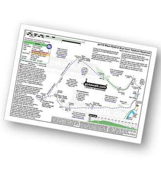
Route Summary:
Talybont Reservoir - Twyn Du (Waun Rydd) - Carn Pica - Craig Pwllfa - Waun Rydd - Gwaun Cerrig Llwydion (Bwlch y Ddwyallt) - Rhiw Bwlch y Ddwyallt - Gist Wen - Ffordd Las or Bwlch Main - Bryn (Waun Rydd) - Bryn Bair - The Usk Valley Walk - Aber Village - Talybont Reservoir
|
Vital Statistics:
| Length: | 13.25 miles (21 km) |
| Ascent: | 3,397ft (1,035m) |
| Time: | 8.25hrs |
| Grade: |  |
Route Summary:
Talybont Reservoir - Allt Lwyd - Gwalciau'r Cwm - Carn Pica - Craig Pwllfa - Waun Rydd - Gwaun Cerrig Llwydion (Bwlch y Ddwyallt) - Graig Fan Las - Craig y Fan Ddu - Blaen y Glyn - The Taff Trail - Pant y Creigiau - Cefn Tarenni Cochion - Bryniau Gleision (Talybont Reservoir) - Darren Fawr - Darren Fach - Pen Bwlch Glasgwm - Pen Rhiw-calch - The Taff Trail - Talybont Reservoir
|
Vital Statistics:
| Length: | 10 miles (16 km) |
| Ascent: | 2,521ft (768m) |
| Time: | 6.25hrs |
| Grade: | |
Route Summary:
Talybont Reservoir - Allt Lwyd - Gwalciau'r Cwm - Carn Pica - Craig Pwllfa - Waun Rydd - Gwaun Cerrig Llwydion (Bwlch y Ddwyallt) - Rhiw Bwlch y Ddwyallt - Gist Wen - Ffordd Las or Bwlch Main - Bryn (Waun Rydd) - Bryn Bair - The Usk Valley Walk - Aber Village - Talybont Reservoir
|
Vital Statistics:
| Length: | 7.75 miles (12.5 km) |
| Ascent: | 2,445ft (745m) |
| Time: | 5.25hrs |
| Grade: | |
Route Summary:
Talybont Reservoir - Allt Lwyd - Gwalciau'r Cwm - Nant Cynafon - Cwar y Gigfran - Gwaun Cerrig Llwydion (Bwlch y Ddwyallt) - Waun Rydd - Craig Pwllfa - Carn Pica - Twyn Du (Waun Rydd) - Berth Lwyd Fach - Nant Tarthwynni - Talybont Reservoir
|
Vital Statistics:
| Length: | 7.5 miles (12 km) |
| Ascent: | 1,736ft (529m) |
| Time: | 4½ hrs |
| Grade: | |

Route Summary:
A470 Nr Llwyn-y-celyn Youth Hostel - Libanus - Craig Cerrig-gleisiad - Fan Frynych - Nant Cwm-du - Craig Cwm-du - Pont Blaen-Cwm-du - Coed y Fan - Twyn Dylluan-ddu - A470.
|
Vital Statistics:
| Length: | 8.25 miles (13 km) |
| Ascent: | 2,009ft (612m) |
| Time: | 5 hrs |
| Grade: | |

Route Summary:
A470 Nr Llwyn-y-celyn Youth Hostel - Libanus - Twyn Dylluan-ddu - Fan Frynych - Craig Cerrig-gleisiad - Rhos Dringarth - Gorllwn - Fan Fawr - Bryn Du - The Storey Arms Outdoor Centre - The Taff Trail - A470.
|
Vital Statistics:
| Length: | 3.75 miles (6 km) |
| Ascent: | 1,099ft (335m) |
| Time: | 2½ hrs |
| Grade: |  |

Route Summary:
A470 Nr Llwyn-y-celyn Youth Hostel - Libanus - Craig Cerrig-gleisiad - Fan Frynych - Twyn Dylluan-ddu - A470.
|
Vital Statistics:
| Length: | 5 miles (8 km) |
| Ascent: | 1,736ft (529m) |
| Time: | 3.75hrs |
| Grade: |  |
Route Summary:
The Storey Arms Outdoor Centre - Y Gyrn - Tommy Jones Obelisk - Craig Cwm Llwch - Corn Du - Pen y Fan - (Penyfan) - Bwlch Duwynt - Craig Gwaun Taf (Bwlch Duwynt) - Blaen Taf Fawr - The Storey Arms Outdoor Centre
|
Vital Statistics:
| Length: | 5.25 miles (8.5 km) |
| Ascent: | 1,736ft (529m) |
| Time: | 3.75hrs |
| Grade: | |

Route Summary:
The Storey Arms Outdoor Centre - Y Gyrn - Tommy Jones Obelisk - Craig Cwm Llwch - Corn Du - Pen y Fan - (Penyfan) - Bwlch Duwynt - Craig Gwaun Taf (Bwlch Duwynt) - Blaen Taf Fawr - The Storey Arms Outdoor Centre
|
Vital Statistics:
| Length: | 8.25 miles (13 km) |
| Ascent: | 1,257ft (383m) |
| Time: | 4.25hrs |
| Grade: | |
Route Summary:
Blaen y Glyn - Pant y Creigiau - Cefn Tarenni Cochion - Bryniau Gleison - Pen Bwlch Glasgwm - Pen Rhiw-calch - The Taff Trail - Blaen y Glyn
Not familiar with the area around LD3?
See these 30 nearest walks to UK Postcode LD3 on a google map
|
Vital Statistics:
| Length: | 5.5 miles (9 km) |
| Ascent: | 1,165ft (355m) |
| Time: | 3.25hrs |
| Grade: | |

Route Summary:
Blaen y Glyn Uchaf - Pant y Creigiau - Cefn Tarenni Cochion - Bryniau Gleison - Darren Fach - The Taff Trail - Blaen y Glyn Uchaf.
|
Vital Statistics:
| Length: | 8.25 miles (13 km) |
| Ascent: | 1,942ft (592m) |
| Time: | 5 hrs |
| Grade: | |

Route Summary:
Blaen y Glyn - Craig y Fan Ddu - Gwaun Cerrig Llwydion (Bwlch y Ddwyallt) - Craig Cwareli - Craig Cwmoergwm - Fan y Big - Bwlch ar y Fan - Roman Road - The Taff Trail - Blaen y Glyn
|
Vital Statistics:
| Length: | 4 miles (6.25 km) |
| Ascent: | 1,736ft (487m) |
| Time: | 3.25hrs |
| Grade: | |
Route Summary:
Pont Ar Daf Car Park - Blaen Taf Fawr - Bwlch Duwynt - Pen y Fan - Craig Cwm Llwch - Corn Du - Pen y Fan - Bwlch Duwynt - Craig Gwaun Taf (Bwlch Duwynt) - Blaen Taf Fawr - Pont Ar Daf Car Park
|
Vital Statistics:
| Length: | 8.5 miles (13.5 km) |
| Ascent: | 2,402ft (732m) |
| Time: | 5½ hrs |
| Grade: | |
Route Summary:
Lower Neuadd Reservoir - Bwlch ar y Fan - Cribyn - Pen y Fan - (Penyfan) - Corn Du - Bwlch Duwynt - Craig Gwaun Taf (Bwlch Duwynt) - Graig Fan Ddu - Lower Neuadd Reservoir
|
Vital Statistics:
| Length: | 10 miles (16 km) |
| Ascent: | 2,850ft (869m) |
| Time: | 6½ hrs |
| Grade: | |
Route Summary:
Lower Neuadd Reservoir - Bwlch ar y Fan - Fan y Big - Cribyn - Pen y Fan - (Penyfan) - Corn Du - Bwlch Duwynt - Craig Gwaun Taf (Bwlch Duwynt) - Graig Fan Ddu - Twyn Mwyalchod - Lower Neuadd Reservoir
|
Vital Statistics:
| Length: | 15 miles (24 km) |
| Ascent: | 3,157ft (962m) |
| Time: | 8½ hrs |
| Grade: | |
Route Summary:
Maen Llia Standing Stone - Fan Nedd - Bwlch y Duwynt - Fan Fraith - Fan Gyhirych - Bwlch Bryn-rhudd - Penwyllt - Carreg Cadno - Sand Hill - Coed-y-Garreg - Sarn Helen Roman Road - Maen Madoc Standing Stone - Plas-y-gors - Blaen Llia - Maen Llia.
|
Vital Statistics:
| Length: | 8.25 miles (13 km) |
| Ascent: | 1,326ft (404m) |
| Time: | 4.25hrs |
| Grade: | |
Route Summary:
Ponsticill - Baltic Quarry - Cefn Yr Ystrad - Cwar Yr Ystrad - Cwar Yr Hendre - Gwaun Danydarren - Gwaun Nant Ddu - Cwm Callan - Dolygaer - Pontsticill Reservoir - Brecon Mountain Railway - Pontsticill Railway Station - Ponsticill
|
Vital Statistics:
| Length: | 13.5 miles (21.5 km) |
| Ascent: | 3,175ft (968m) |
| Time: | 8 hrs |
| Grade: | |

Route Summary:
Nuadd-fawr - Llanbedr - Table Mountain (Pen Cerrig-calch) - Trwyn Ysgwrfa - Pen Cerrig-calch - Pen Allt-mawr - Pen Twyn Glas - Mynydd Llysiau - Pen Trumau - Waun Fach - Pen y Gadair Fawr - Pen Twyn Mawr - Pen Gwyllt Meirch - Nantyrychain - Cwm Farm - Nuadd-fawr
|
Vital Statistics:
| Length: | 11 miles (17.5 km) |
| Ascent: | 2,430ft (741m) |
| Time: | 6½ hrs |
| Grade: | |

Route Summary:
Nuadd-fawr - Llanbedr - Table Mountain (Pen Cerrig-calch) - Trwyn Ysgwrfa - Pen Cerrig-calch - Pen Allt-mawr - Pen Twyn Glas - Mynydd Llysiau - Tal-y-maes Bridge - Hermitage Bridge - Cwm Farm - Nuadd-fawr
|
Vital Statistics:
| Length: | 12 miles (19 km) |
| Ascent: | 2,637ft (804m) |
| Time: | 7 hrs |
| Grade: | |

Route Summary:
Nuadd-fawr - Llanbedr - Darren Fach - Pen Twyn Glas - Mynydd Llysiau - Pen Trumau - Waun Fach - Pen y Gadair Fawr - Pen Twyn Mawr - Pen Gwyllt Meirch - Nantyrychain - Cwm Farm - Nuadd-fawr
|
Vital Statistics:
| Length: | 6.25 miles (10 km) |
| Ascent: | 1,879ft (573m) |
| Time: | 4.25hrs |
| Grade: | |
Route Summary:
Neuadd-fawr - Llanbedr - Ty-Croes Farm - Table Mountain (Pen Cerrig-calch) - Trwyn Ysgwrfa - Pen Cerrig-calch - Pen Allt-mawr - Pen Twyn Glas - Tal Trwynau - Darren Fach - Neuadd-fawr.
|
Vital Statistics:
| Length: | 9.75 miles (15.5 km) |
| Ascent: | 2,402ft (732m) |
| Time: | 6 hrs |
| Grade: | |

Route Summary:
Blaen Llia Picnic Area - Fan Llia - Fan Dringarth - Cefn Perfedd - Craig Cwm-du - Rhos Dringarth - Craig Cerrig-gleisiad - Gorllwn - Fan Fawr - Ystradfellte Reservoir - Cwm Dringarth - Blaen Llia.
|
Vital Statistics:
| Length: | 4.75 miles (7.5 km) |
| Ascent: | 1,024ft (312m) |
| Time: | 2.75hrs |
| Grade: | |
Route Summary:
Blaen Llia Picnic Area - Fan Llia - Rhyd Uchaf - Maen Llia Standing Stone - Sarn Helen Roman Road - Blaen Llia.
|
Vital Statistics:
| Length: | 10.5 miles (17 km) |
| Ascent: | 1,569ft (478m) |
| Time: | 5½ hrs |
| Grade: | |
Route Summary:
Blaen Llia Picnic Area - Fan Llia - Fan Dringarth - Cefn Perfedd - Craig Cwm-du - Rhos Dringarth - Craig Cerrig-gleisiad - Fan Frynych - Nant Cwm-du - Pont Blaen Cwm-du - Sran Heln Roman Road - Maen Llia Standing Stone - Rhyd Uchaf - Blaen Llia.
|
Vital Statistics:
| Length: | 8.5 miles (13.5 km) |
| Ascent: | 1,792ft (546m) |
| Time: | 5 hrs |
| Grade: | |
Route Summary:
Pont Gihirych (Cray Reservoir) - Heol Senni (Fan Bwlch Chwyth) - Yr Allt (Forest Fawr) - Bwlch y Duwynt - Fan Fraith - Fan Gyhirych - Bwlch Bryn-fhudd - Pont Gihirych.
Not familiar with the area around LD3?
See these 30 nearest walks to UK Postcode LD3 on a google map


