UK Postcode S5 - The 30 nearest easy-to-follow, circular walk route maps to you
The thirty nearest easy-to-follow, circular walk route maps to you in UK Postcode S5 in Walk Grade Order
The UK cities, towns and villages in South Yorkshire, England that have S5 in their UK Postcode include:
• Fir Vale • Wadsley Bridge •
Not familiar with the area around S5?
See these 30 nearest walks to UK Postcode S5 on a google map
   |
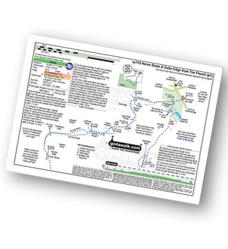
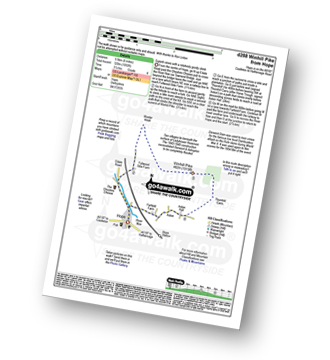
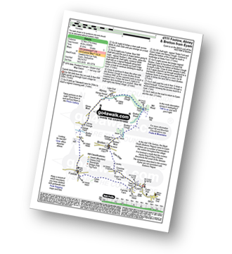
Vital Statistics:
| Length: | 4.5 miles (7 km) |
| Ascent: | 804ft (245m) |
| Time: | 2½ hrs |
| Grade: |  |
Route Summary:
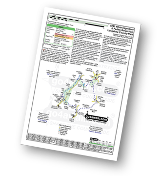
Longshaw Country Park - Woodcroft Car Park - Wooden Pool - White Edge Moor - White Edge Lodge - Nether Padley - Oaks Wood - Grindleford Station - Padley Gorge - Lawrence Field - Burbage Brook - Granby Barn - Granby Wood - Longshaw Pond - Longshaw Country Park
|
Vital Statistics:
| Length: | 5.5 miles (8.5 km) |
| Ascent: | 1,007ft (307m) |
| Time: | 3 hrs |
| Grade: |  |
Route Summary:
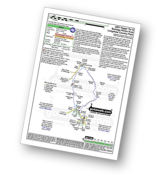
Longshaw Country Park - Woodcroft Car Park - Burbage Brook - Burbage Bridge - Toad's Mouth - Hathersage Moor - Carl Wark - Higger Tor - Upper Burbage Bridge - Burbage Moor - Burbage Rocks - Longshaw Country Park
|
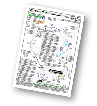
Vital Statistics:
| Length: | 8.5 miles (13.5 km) |
| Ascent: | 896ft (273m) |
| Time: | 4 hrs |
| Grade: | |

Route Summary:
Longshaw Country Park - Woodcroft Car Park - Wooden Pole - White Edge Moor - White Edge (Big Moor) - White Edge (Big Moor) (South East Top) - Curbar Gap - Curbar Edge - Froggatt Edge - Hay Wood - Longshaw Estate - Sheffield Plantation - Longshaw Lodge - Longshaw Country Park
|
Vital Statistics:
| Length: | 9.5 miles (15 km) |
| Ascent: | 2,097ft (639m) |
| Time: | 5½ hrs |
| Grade: |  |
Route Summary:
Hathersage - Hathersage Pinfold - Toothill Farm - Hookcar Sitch - Overstones Farm - Cowper Stone - Stanage Edge (Stanage Edge) - Hook's Car - White Path Moss - Robin Hood's Cave - Stanage Plantation - Long Causeway - Stanage Edge - High Neb (Stanage Edge) - Crow Chin - Moscar Moor - Bamford Moor - Upper Hurst Brook - Bole Hill (Bamford) - Bolehill Wood - Upper Hurst Farm - Gatehouse Farm - Hurstclough Lane - Nether Hurst Farm - Coggers Lane - Hathersage
|
Vital Statistics:
| Length: | 8.75 miles (14 km) |
| Ascent: | 1,887ft (575m) |
| Time: | 5.25hrs |
| Grade: | |

Route Summary:
Yorkshire Bridge - Parkin Clough - Winhill Plantation - Winhill Pike (Win Hill) - Twitchill Farm - Fullwood Stile Farm - Roman Road - Hope Cross - Ladybower Reservoir - Wiseman Hey Clough Plantation - Yorkshire Bridge
|
Vital Statistics:
| Length: | 6.75 miles (10.5 km) |
| Ascent: | 1,289ft (393m) |
| Time: | 3.75hrs |
| Grade: | |

Route Summary:
Heatherdene Car Park - Ladybower Reservoir - Yorkshire Bridge - Parkin Clough - Winhill Plantation - Winhill Pike (Win Hill) - Hope Bank - Wooler Knoll - Woodlands Valley - Ladybower Reservoir - Wiseman Hey Clough Plantation - Yorkshire Bridge - Heatherdene Car Park
|
Vital Statistics:
| Length: | 10.75 miles (17 km) |
| Ascent: | 1,493ft (455m) |
| Time: | 5½ hrs |
| Grade: | |

Route Summary:
Grindleford Station - Oaks Wood - Nether Padley - White Edge Moor - Hurkling Stone - White Edge - White Edge (Big Moor) - White Edge (Big Moor) (South East Top) - Curbar Gap - Baslow Edge - Eaglestone Flat - Eagle Stone - Wellington's Monument - Over End - Baslow - The Derwent Valley Heritage Way - Bridge End - River Derwent - Bubnell - Townend Wood - St Mary's Wood - Curbar - Stocking Farm - New Bridge - Froggatt Bridge - Derwent Farm - Horse Hay Coppice - Grindleford - Grindleford Station
|
Vital Statistics:
| Length: | 7.5 miles (12 km) |
| Ascent: | 1,467ft (447m) |
| Time: | 4.25hrs |
| Grade: |  |

Route Summary:
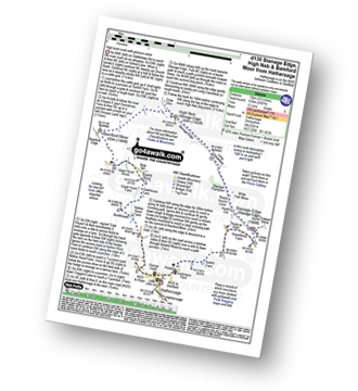
Grindleford Station - Padley Gorge - Lawrence Field - Toad's Mouth - Hathersage Moor - Carl Wark - Higger Tor - Fiddler's Elbow - Upper Burbage Bridge - Burbage Moor - Burbage Rocks - Longshaw Country Park - Sheffield Plantation - Nether Padley - Oaks Wood - Grindleford Station
|
Vital Statistics:
| Length: | 10 miles (16 km) |
| Ascent: | 1,568ft (478m) |
| Time: | 5.25hrs |
| Grade: | |

Route Summary:
Ashopton Bridge - Ladybower Reservoir - Ashopton - Whinstone Lee Tor - Hurkling Stones - Wheel Stones - White Tor (Derwent Edge) - Salt Cellar (Boulder) - Derwent Edge - Dove Stone (Boulder) - Dovestones Tor - Cakes of Bread - Bradfield Gate Head - Back Tor (Derwent Edge) - Lost Lad - Bamford House - Little Howden Moor - Derwent Reservoir - Derwent Valley - Ladybower Reservoir - Ashopton Bridge..
|
Vital Statistics:
| Length: | 10 miles (16 km) |
| Ascent: | 515ft (157m) |
| Time: | 4½ hrs |
| Grade: | |

Route Summary:
Harthill - Woodall - The Cuckoo Way - Kiveton Waters - Chesterfield Canal - Kiveton - Kiveton Park - Hawks Wood - Old Spring Wood - Turnerwood - Brook House Top Farm - Top Hall Farm - Crow Wood - Harthill
|
Vital Statistics:
| Length: | 8.25 miles (13 km) |
| Ascent: | 404ft (123m) |
| Time: | 3½ hrs |
| Grade: | |

Route Summary:
Harthill - Woodall - The Cuckoo Way - Kiveton Waters - Chesterfield Canal - Kiveton - Kiveton Park - Hawks Wood - Thorpe Salvin - Loscar Wood - Crow Wood - Harthill
|
Vital Statistics:
| Length: | 3.75 miles (6.5 km) |
| Ascent: | 673ft (205m) |
| Time: | 2.25hrs |
| Grade: | |
Route Summary:
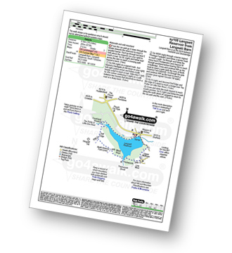
Langsett Barn - Langsett - Langsett Reservoir Dam - Upper Midhope - Thickwoods - Thickwoods Brook - North America Farm - Delf Edge - Langsett Reservoir - The Porter or Little Don River - Crookland Wood - Langsett Reservoir - Langsett Barn
|
Vital Statistics:
| Length: | 7.5 miles (12 km) |
| Ascent: | 1,118ft (360m) |
| Time: | 4 hrs |
| Grade: | |

Route Summary:
Langsett Barn - Langsett - Langsett Reservoir - Langsett Reservoir Dam - Upper Midhope - Thickwoods - Thickwoods Brook - Fenny Common Ings - Fenny Common - Pike Lowe Stones - Pike Lowe - Candlerush Edge - Sugden Top - Lost Lad (Langsett) - Mickleden Edge (Langsett) - Haslingshaw Hingcliff Common - Delf Edge - Langsett Reservoir - The Porter or Little Don River - Crookland Wood - Langsett Reservoir - Langsett Barn
|
Vital Statistics:
| Length: | 6.75 miles (11 km) |
| Ascent: | 1,122ft (342m) |
| Time: | 3.75hrs |
| Grade: | |

Route Summary:
Hay Wood - Longshaw - Froggatt Edge - Curbar Edge - Curbar - The Derwent Valley Heritage Way - The River Derwent - Stocking Farm - The Goit - New Bridge - Stoke Brook - Froggatt Bridge - Derwent Farm - Horse Hay Coppice - Grindleford - Grindleford Church - Hay Wood
|
Vital Statistics:
| Length: | 4.75 miles (7.5 km) |
| Ascent: | 1,195ft (364m) |
| Time: | 3 hrs |
| Grade: | |

Route Summary:
Ladybower Reservoir - Bridge End Car Park - Ridges Coppice - Hagg Side - Open Hagg - Longley Bank - Bridge-end Pasture - Crook Hill (Ladybower) - Crook Hill (Ladybower) (South Top) - Crookhill Farm - Ladybower Reservoir - Hurst Clough Car Park - Bridge End Car Park.
Not familiar with the area around S5?
See these 30 nearest walks to UK Postcode S5 on a google map
|
Vital Statistics:
| Length: | 11.5 miles (18.5 km) |
| Ascent: | 1,674ft (510m) |
| Time: | 6 hrs |
| Grade: | |
Route Summary:
The Flouch Car Park - Crookland Wood - Swinden Lane - Fox Clough - Langsett Moors - Barmings - Hordron Road - Long Moor Clough - Hordron Clough - The Porter or Little Don River - Laund Clough - Harden Moor - Howden Edge - Hoar Stones - Horse Stone (Horse Stone Naze) - Stainery Clough Head - Howden Moors - Crow Stones - Crow Stones Edge - Outer Edge - Cut Gate End - Cut Gate Path - Mickleden Edge - Delf Edge - Langsett Reservoir - The Porter or Little Don River - The Flouch.
|
Vital Statistics:
| Length: | 10 miles (16 km) |
| Ascent: | 2,368ft (722m) |
| Time: | 6 hrs |
| Grade: | |

Route Summary:
Ladybower Reservoir - Fairholmes Car Park - Lockerbrook Farm - Lockerbrook Heights - Rowlee Pasture - Alport Castles - River Alport - Alport Dale - Alport Farm - Hayridge Farm - Upper Ashop - Blackley Clough - Hagg Farm - Hagg Side - Fairholmes Car Park - Ladybower Reservoir
|
Vital Statistics:
| Length: | 12.75 miles (20.5 km) |
| Ascent: | 2,094ft (638m) |
| Time: | 6.75hrs |
| Grade: |  |

Route Summary:
Ladybower Reservoir - Fairholmes Car Park - Derwent Reservoir - Abbey Bank - Abbey Brook - Hey Bank (Nether Hey) - Howden Moors - Nether Hey (Howden Edge) - Row Top - Featherbed Moss (Howden Edge) - High Stones (Howden Moor) - Willfrey Edge - High Peak - Margery Stones - Margery Hill - Outer Edge - Crow Stones - Crow Stones Edge - Airspeed Consul TF-RPM Plane Wreckage - Broadhead Clough - Cranberry Bed - Swine Side - Cranberry Clough - Cold Side Oaks - Slippery Stones - Packhorse Bridge (River Derwent) - Howden Reservoir - Cold Side (Howden Reservoir) - Derwent Reservoir - Fairholmes Car Park - Ladybower Reservoir
|
Vital Statistics:
| Length: | 13.75 miles (22 km) |
| Ascent: | 2,061ft (628m) |
| Time: | 7 hrs |
| Grade: | |

Route Summary:
Ladybower Reservoir - Fairholmes Car Park - Ashopton - Whinstone Lee Tor - Hurkling Stones - Wheel Stones - White Tor (Derwent Edge) - Salt Cellar (Boulder) - Derwent Edge - Dove Stone (Boulder) - Dovestones Tor - Cakes of Bread - Bradfield Gate Head - Back Tor (Derwent Edge) - Lost Lad - Sheepfold Clough - Abbey Brook - Howden Dean - Abbey Tip Plantation - Derwent Reservoir - Fairholmes Car Park - Ladybower Reservoir
|
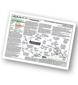
Vital Statistics:
| Length: | 16.5 miles (26.5 km) |
| Ascent: | 2,604ft (794m) |
| Time: | 8½ hrs |
| Grade: |  |

Route Summary:
Ladybower Reservoir - Fairholmes Car Park - Derwent Reservoir - Howden Reservoir - Fagney Clough - Ridgewalk Moor - Barrow Stones - Bleaklow Stones (Bleaklow Hill) - Alport Moor - West End Moor - Birchin Hat - Alport Castles - Rowlee Pasture - Lockerbrook Heights - Lockerbrook Farm - Fairholmes Car Park - Ladybower Reservoir
|
Vital Statistics:
| Length: | 19.75 miles (31.5 km) |
| Ascent: | 2,757ft (840m) |
| Time: | 9.75hrs |
| Grade: | |

Route Summary:
Ladybower Reservoir - Fairholmes Car Park - Ashopton - Whinstone Lee Tor - Hurkling Stones - Wheel Stones - White Tor (Derwent Edge) - Salt Cellar (Boulder) - Derwent Edge - Dove Stone (Boulder) - Dovestones Tor - Cakes of Bread - Bradfield Gate Head - Back Tor (Derwent Edge) - Abbey Brook - High Peak - Howden Moors - Featherbed Moss (Howden Edge) - High Stones (Howden Moor) - Margery Hill - Outer Edge - Crow Stones - Crow Stones Edge - Airspeed Consul TF-RPM Plane Wreckage - Broadhead Clough - Cranberry Bed - Bull Clough - Cranberry Clough - Slippery Stones - Packhorse Bridge (River Derwent) - Howden Reservoir - Cold Side (Howden Reservoir) - Derwent Reservoir - Fairholmes Car Park - Ladybower Reservoir
|
Vital Statistics:
| Length: | 6 miles (9.5 km) |
| Ascent: | 331ft (101m) |
| Time: | 2½ hrs |
| Grade: |  |
Route Summary:
Thorpe Salvin - Hawks Wood - The Cuckoo Way - Chesterfield Canal - Old Spring Wood - Turnerwood - Crow Wood - Thorpe Salvin
|
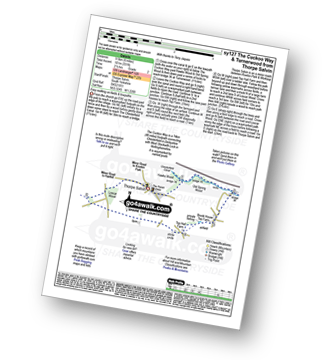
Vital Statistics:
| Length: | 9.75 miles (15.5 km) |
| Ascent: | 1,001ft (305m) |
| Time: | 4.75hrs |
| Grade: | |
Route Summary:
Curbar Gap - Curbar Edge - Froggatt Edge - Hay Wood - Longshaw (A621) - White Edge Lodge - White Edge Moor - Barbrook Bridge - Barbrook Reservoir - Bar Brook - Big Moor - Ramsley Moor - Ramsley Reservoir - Blake Brook - Wellington's Monument - Eagle Stone - Eaglestone Flat - Baslow Edge - Curbar Gap
|
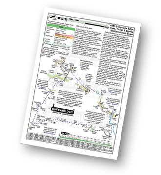
Vital Statistics:
| Length: | 9.5 miles (15 km) |
| Ascent: | 1,588ft (484m) |
| Time: | 5 hrs |
| Grade: | |
Route Summary:
Hope - Townhead Bridge - Losehill End - Lose Hill (Ward's Piece) - Back Tor (Hollins Cross) - Barker Bank - Hollins Cross - Mam Tor Farm - Knowlgate Farm - Odin Sitch - Castleton - Hollowford Centre - Spring House Farm - Hope
|
Vital Statistics:
| Length: | 5.75 miles (9 km) |
| Ascent: | 971ft (296m) |
| Time: | 3 hrs |
| Grade: | |
Route Summary:
Hope - Hope Bank - Wooler Knoll - Winhill Plantation - Winhill Pike (Win Hill) - Thornhill - Aston - Hope
|
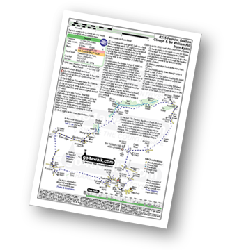
Vital Statistics:
| Length: | 11.75 miles (19 km) |
| Ascent: | 1,989ft (606m) |
| Time: | 6.25hrs |
| Grade: | |

Route Summary:
Eyam - The Cliff - Stoney Middleton - Coombs Dale - Sallet Hole Mine - Rough Side - Black Harry Gate - Blakedon Hollow - High Rake - Longstone Edge - Watershaw Rake - Longstone Moor - Wardlow Hay Cop - Cressbrook Dale - Tansley Dale - Wardlow Mires - Stanley House Farm - Silly Dale - Foolow - Linen Dale - Eyam
|
Vital Statistics:
| Length: | 9.75 miles (15.5 km) |
| Ascent: | 1,697ft (517m) |
| Time: | 5.25hrs |
| Grade: | |
Route Summary:
Eyam - Foolow - Eyam Edge - Bretton - Bretton Clough - Abney Clough - Stoke Ford - Mill Wood - Brook Wood - Hazelford - Leam - Eyam Moor - Sir William Hill - Eyam
|
Vital Statistics:
| Length: | 9.5 miles (15 km) |
| Ascent: | 1,792ft (546m) |
| Time: | 5.25hrs |
| Grade: | |
Route Summary:
Eyam - Eyam Dale - Middleton Dale - Dalton Quarry - High Fields - Black Harry Lane - Black Harry Gate - Blakedon Hollow - Longstone Edge - High Rake - Deep Rake - Bramley Wood - Bramley Farm - Townend Wood - The Dane Valley Heritage Way - St Mary's Wood - Calver - Stoney Middleton - The Cliff - Eyam
|
Vital Statistics:
| Length: | 6.25 miles (10 km) |
| Ascent: | 1,246ft (380m) |
| Time: | 3½ hrs |
| Grade: | |
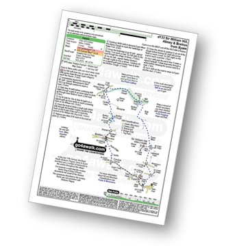
Route Summary:
Eyam - Sir William Hill - Eyam Moor - Bole Hill (Highlow) - Stoke Ford - Abney Clough - Abney - Cockey Farm - Bretton Clough - Bretton - Eyam
|
Vital Statistics:
| Length: | 7.5 miles (12.5 km) |
| Ascent: | 722ft (220m) |
| Time: | 3½ hrs |
| Grade: | |
Route Summary:
Eyam - Town Head - Linen Dale - Foolow - Bretton Brook - Grange Farm - Abney Grange - Abney - Abney Clough - Stoke Ford - Bretton Brook - Bretton Clough - Bretton - Eyam Edge - Eyam
Not familiar with the area around S5?
See these 30 nearest walks to UK Postcode S5 on a google map


