UK Postcode LL16 - The 30 nearest easy-to-follow, circular walk route maps to you
The thirty nearest easy-to-follow, circular walk route maps to you in UK Postcode LL16 in Walk Grade Order
The UK cities, towns and villages in Denbighshire, Wales that have LL16 in their UK Postcode include:
• Bodfari • Bylchau • Denbigh • Deunant • Ffordd-las • Groes • Gwaynynog • Henllan • Llandyrnog • Llangwyfan • Llangynhafal • Llannefydd • Llanrhaeadr • Llansannan • Llanynys • Nantglyn • Pant-pastynog • Pentre Llanrhaeadr • Pentre Saron • Plasisaf • Tan-y-fron • Trefnant • Waen •
Not familiar with the area around LL16?
See these 30 nearest walks to UK Postcode LL16 on a google map
   |
Vital Statistics:
| Length: | 12.25 miles (19.5 km) |
| Ascent: | 1,874ft (571m) |
| Time: | 6.25hrs |
| Grade: |  |

Route Summary:
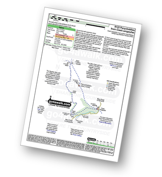
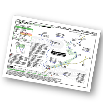
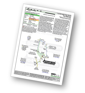
Bodfari - The Offa's Dyke Path - Moel-y-Gaer - Pen y Bryn - Sodom Covert - Cefn Du - Pant Glas - Moel Maenefa - Bryn Gronw - Cobweb Cottage - Brick Kiln Rough - Ty Hir - Rhos Onnen - Croes-wian - Caerwys - Maes-mynan Hall - Candy Mill - Ty-draw - The Offa's Dyke Path - Bodfari
|
Vital Statistics:
| Length: | 9.75 miles (15.5 km) |
| Ascent: | 1,447ft (441m) |
| Time: | 5 hrs |
| Grade: |  |

Route Summary:
Bodfari - The Offa's Dyke Path - Moel-y-Gaer - Pen y Bryn - Sodom Covert - Cefn Du - Pant Glas - Coed Bron-fawr - Bryngwyn Hall - Ffrith Farm - Croes-wian - Caerwys - Maes-mynan Hall - Candy Mill - Ty-draw - The Offa's Dyke Path - Bodfari
|
Vital Statistics:
| Length: | 5 miles (8 km) |
| Ascent: | 994ft (303m) |
| Time: | 3 hrs |
| Grade: |  |
|
Vital Statistics:
| Length: | 7.5 miles (12 km) |
| Ascent: | 962ft (293m) |
| Time: | 3.75hrs |
| Grade: |  |

Route Summary:
Rhuallt - The Offa's Dyke Path - A55 - Bryn Gronw - Cobweb Cottage - Ty Hir - Rhos Onnen - Croes-wian - Ffrith Farm - Bryngwyn Hall - Coed Bron-fawr - The Offa's Dyke Path - Bryn Gronw - A55 - Rhuallt
|
Vital Statistics:
| Length: | 9.5 miles (15 km) |
| Ascent: | 1,359ft (141m) |
| Time: | 4.75hrs |
| Grade: | |
Route Summary:
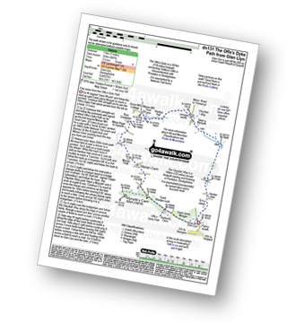
Rhuallt - The Offa's Dyke Path - Brynllithrig Hall - Pen-y-mynydd - Coed Rhedyn-coch - Mynydd y Cwm (Coed Cwm) - Marian Cwm - Marian Ffrith - Bryn Cnewyllyn - Marian Mill Trout Farm - Henfryn Hall - The Clwydian Way - Swyn y Mynydd - Hendre Fawr - Glan Llyn - Bryn Gronw - Rhuallt
|
Vital Statistics:
| Length: | 4 miles (6.5 km) |
| Ascent: | 715ft (218m) |
| Time: | 2.25hrs |
| Grade: | |

Route Summary:
Rhuallt - The Offa's Dyke Path - Brynllithrig Hall - Pen-y-mynydd - Coed Jenny Morgan - Glan Llyn - Bryn Gronw - Rhuallt
|
Vital Statistics:
| Length: | 4 miles (6.5 km) |
| Ascent: | 1,086ft (331m) |
| Time: | 2½ hrs |
| Grade: | |

|
Vital Statistics:
| Length: | 7.5 miles (12 km) |
| Ascent: | 1,746ft (532m) |
| Time: | 4½ hrs |
| Grade: | |
Route Summary:
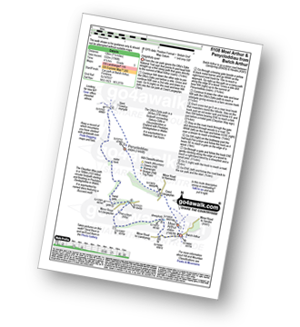
Bwlch Arthur - Moel Arthur - Coed Llangwyfan - Penycloddiau - Nant Coed-y-mynydd - Pen-y-bryn - Bwlch Arthur
|
Vital Statistics:
| Length: | 7 miles (11 km) |
| Ascent: | 847ft (258m) |
| Time: | 3½ hrs |
| Grade: | |
Route Summary:
Glan Llyn - Coed Jenny Morgan - The Offa's Dyke Path - Coed Rhedyn-coch - Mynydd y Cwm (Coed Cwm) - Marian Cwm - Marian Ffrith - Bryn Cnewyllyn - Marian Mill Trout Farm - Henfryn Hall - The Clwydian Way - Swyn y Mynydd - Hendre Fawr - Glan Llyn
|
Vital Statistics:
| Length: | 5.5 miles (9 km) |
| Ascent: | 1,362ft (415m) |
| Time: | 3½ hrs |
| Grade: | |

|
Vital Statistics:
| Length: | 12 miles (19 km) |
| Ascent: | 2,409ft (734m) |
| Time: | 6.75hrs |
| Grade: |  |
Route Summary:
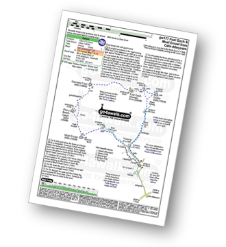
Bwlch Penbarras - The Offa's Dyke Path - Moel Famau - Moel Dywyll - Moel Llys-y-coed - Bwlch Arthur - Gronfoel Farm - Cilcain - Y Pentre - Crug Farm - Ffrith - Bryn Fynnon - Moel Famua Country Park - Bwlch Penbarras
|
Vital Statistics:
| Length: | 8.25 miles (13 km) |
| Ascent: | 1,943ft (592m) |
| Time: | 5 hrs |
| Grade: | |

Route Summary:
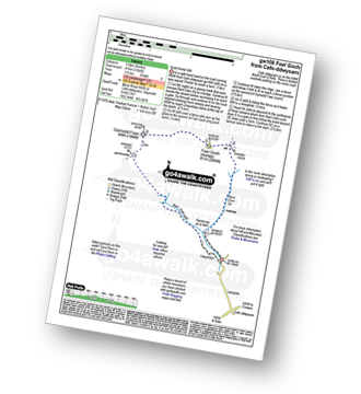
Cilcain - Y Pentre - Crug Farm - Ffrith - Bryn Fynnon - Moel Famau Country Park - Moel Famau - The Offa's Dyke Path - Moel Dywyll - Moel Llys-y-coed - Bwlch Arthur - Gronfoel Farm - Cilcain
|
Vital Statistics:
| Length: | 11 miles (17.5 km) |
| Ascent: | 2,389ft (728m) |
| Time: | 6½ hrs |
| Grade: | |

Route Summary:
Moel Famau Country Park - Moel Famau - The Offa's Dyke Path - Moel Dywyll - Moel Llys-y-coed - Bwlch Arthur - Gronfoel Farm - Cilcain - Y Pentre - Crug Farm - Ffrith - Bryn Fynnon - Moel Famau Country Park
|
Vital Statistics:
| Length: | 3.75 miles (6 km) |
| Ascent: | 961ft (293m) |
| Time: | 2½ hrs |
| Grade: | |

|
Vital Statistics:
| Length: | 9.75 miles (15.5 km) |
| Ascent: | 1,303ft (397m) |
| Time: | 4.75hrs |
| Grade: | |
Route Summary:
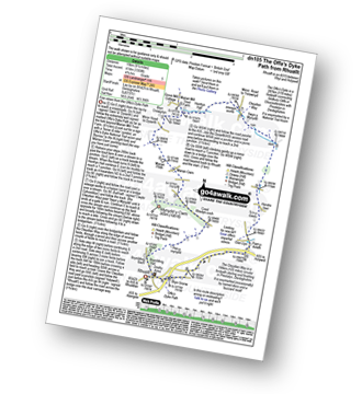
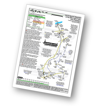
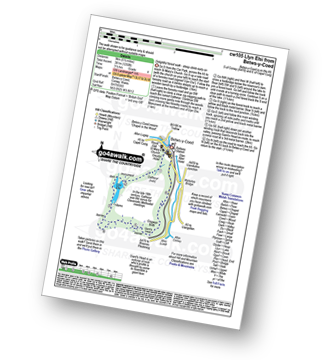
Prestatyn - The North Wales Path - Dyserth - Dyserth Waterfall - The Offa's Dyke Path - Ty Newydd - Bryniau - Red Roofs - Crag y Fran - Prestatyn
Not familiar with the area around LL16?
See these 30 nearest walks to UK Postcode LL16 on a google map
|
Vital Statistics:
| Length: | 10.75 miles (17 km) |
| Ascent: | 916ft (279m) |
| Time: | 4.75hrs |
| Grade: | |
Route Summary:
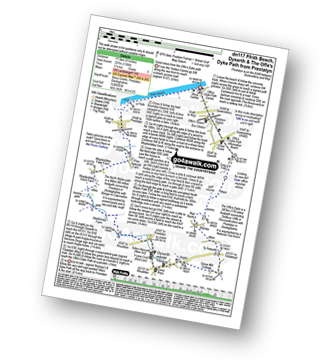
Prestatyn - Ffrith Beach - Plas Newydd Farm - Rhydorddwy Goch Farm - Aberkinsey Farm - Dyserth - Dyserth Waterfall - The Offa's Dyke Path - Ty Newydd - Bryniau - Red Roofs - Crag y Fran - Prestatyn
|
Vital Statistics:
| Length: | 12.25 miles (19.5 km) |
| Ascent: | 2,356ft (718m) |
| Time: | 6.75hrs |
| Grade: | |

Route Summary:
Cynwyd - Afon Trystion - Cynwyd Forest - Pen Creigiau'r Barcut - Bwlch Cynwyd - Moel Fferna - Cerrig Coediog - Pan y Ladron - Pen Bwlch Llandrillo Top - Bwlch Llandrillo Wayfarer Memorial - Nant Gwyn - Nat y Cwm - Rhos-y-maerdy - Cynwyd
|
Vital Statistics:
| Length: | 15.5 miles (25 km) |
| Ascent: | 3,157ft (962m) |
| Time: | 8.75hrs |
| Grade: |  |
Route Summary:
Cynwyd - Afon Trystion - Cynwyd Forest - Pen Creigiau'r Barcut - Bwlch Cynwyd - Moel Fferna - Cerrig Coediog - Pan y Ladron - Pen Bwlch Llandrillo Top - Bwlch Llandrillo Wayfarer Memorial - Blaen Llynor - Cadair Bronwen (North Top) - Cadair Bronwen - Bwlch Llandrillo Wayfarer Memorial - Nant Gwyn - Nat y Cwm - Rhos-y-maerdy - Cynwyd
|
Vital Statistics:
| Length: | 3 miles (5 km) |
| Ascent: | 542ft (165m) |
| Time: | 2 hrs |
| Grade: |  |
Route Summary:
Maenan - Cadair Ifan Goch - Bryn Hyfryd - Pant-yr-ych Bach Farm - Maes-yr-Groes - Tyn-y-graig - Maenan
|
Vital Statistics:
| Length: | 5.5 miles (9 km) |
| Ascent: | 1,250ft (381m) |
| Time: | 3½ hrs |
| Grade: | |
|
Vital Statistics:
| Length: | 6 miles (9.5 km) |
| Ascent: | 1,364ft (416m) |
| Time: | 3½ hrs |
| Grade: | |
Route Summary:
Cefn-ddwysarn - Pentre-tai-yn-y-cwm - Nant Cwm Da - Foel Goch (Arenigs) - Garnedd Fawr - Nant Cefn-coch - Cefn-ddwysarn
|
Vital Statistics:
| Length: | 7.5 miles (12 km) |
| Ascent: | 1,963ft (598m) |
| Time: | 4.75hrs |
| Grade: | |
Route Summary:
Cefn-ddwysarn - Pentre-tai-yn-y-cwm - Nant Cwm Da - Waun Tafolog - Orddu - Foel Goch (Arenigs) - Garnedd Fawr - Pen y Bwlch Gwyn - Moel Emoel - Nant Cefn-coch - Tir Gofal - Llwyniolyn - Cefn-ddwysarn
|
Vital Statistics:
| Length: | 10.25 miles (16.5 km) |
| Ascent: | 2,627ft (801m) |
| Time: | 6½ hrs |
| Grade: | |
Route Summary:
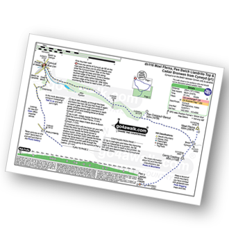
Llandrillo - Pont Rhyd-yr-hydd - Bwlch Llandrillo Wayfarer Memorial - Pen Bwlch Llandrillo Top - Cadair Bronwen (North Top) - Cadair Bronwen - Bwlch Maen Gwynedd - Ffordd Gan Elin - Llandrillo
|
Vital Statistics:
| Length: | 16.25 miles (26 km) |
| Ascent: | 3,213ft (979m) |
| Time: | 9 hrs |
| Grade: | |

Route Summary:
Llandrillo - Pont Rhyd-yr-hydd - Bwlch Llandrillo Wayfarer Memorial - Pen Bwlch Llandrillo Top - Bronwen (North Top) - Cadair Bronwen - Bwlch Maen Gwynedd - Craig Berwyn - Cadair Berwyn - Cadair Berwyn (North Top) - Moel Sych - Ceulan Myheryn - Milltir Gerrig - Blaen-y-cwm - Llandrillo
|
Vital Statistics:
| Length: | 7.75 miles (12.5 km) |
| Ascent: | 2,785ft (849m) |
| Time: | 5.75hrs |
| Grade: | |

Route Summary:
Llyn Crafnant - Crimpiau - Craig Wen - Craiglwyn - Creigiau Gleision - Creigiau Gleision (North Top) - Lledwigan - Llyn Crafnant
|
Vital Statistics:
| Length: | 5 miles (8 km) |
| Ascent: | 843ft (257m) |
| Time: | 2½ hrs |
| Grade: | |

Route Summary:
Llandderfel - Llyn Bodweni - Afron Dyfrdwy (River Dee) - Bryn-Banon - Coed Bryn Banon - Ty'n-y-bwlch - Llyn Maes-y-clawydd - Coed Hen-blas - Llandderfel
|
Vital Statistics:
| Length: | 7.5 miles (12 km) |
| Ascent: | 1,841ft (561m) |
| Time: | 4.75hrs |
| Grade: | |

Route Summary:
Llyn Celyn - Ffridd Bwlch-gwyhn - Nant y Coed - Brottos - Carnedd y Filiast (Arenigs) - Waun Garnedd-y-filiast - Carnedd Llechwedd-llyfn - Llechwedd-llyfnr - Foel-boeth (Llyn Celyn) - Llyn Celyn
|
Vital Statistics:
| Length: | 12.75 miles (20.5 km) |
| Ascent: | 2,939ft (896m) |
| Time: | 7.75hrs |
| Grade: | |

Route Summary:
Llyn Celyn - Nant y Coed - Brottos - Carnedd y Filiast (Arenigs) - Waun Garnedd-y-Filiast - Carnedd y Filiast (Arenigs) - Carnedd Llechwedd-llyfn - Afon Celyn - Trinant - Arenig Fach - Capel Celyn - Llyn Celyn
|
Vital Statistics:
| Length: | 11 miles (17.5 km) |
| Ascent: | 3,641ft (1,110m) |
| Time: | 7.75hrs |
| Grade: | |

Route Summary:
Llyn Eigiau - Craig Eigiau - Gwaun Y Garnedd - Foel Grach - Carnedd Llewelyn - Craig Yr Ysfa - Bwlch Eryl Farchog - Pen yr Helgi Du - Bwlch y Tri Marchog - Pen Llithrig y Wrach - Cedryn - Hafod-y-rhrw - Llyn Eigiau
|
Vital Statistics:
| Length: | 10 miles (16 km) |
| Ascent: | 3,027ft (923m) |
| Time: | 6½ hrs |
| Grade: | |

Route Summary:
Llyn Eigiau - Hafod-y-rhrw - Cedryn - Pen Llithrig y Wrach - Llyn Colwyd Reservoir - Craiglwyn - Creigiau Gleision - Creigiau Gleision (North Top) - Eilio Farm - Llyn Eigiau
Not familiar with the area around LL16?
See these 30 nearest walks to UK Postcode LL16 on a google map


