UK Postcode G43 - The 30 nearest easy-to-follow, circular walk route maps to you
The thirty nearest easy-to-follow, circular walk route maps to you in UK Postcode G43 in Walk Grade Order
The UK cities, towns and villages in Glasgow City, Scotland that have G43 in their UK Postcode include:
• Pollokshaws •
Not familiar with the area around G43?
See these 30 nearest walks to UK Postcode G43 on a google map
   |
Vital Statistics:
| Length: | 2.75 miles (4.5 km) |
| Ascent: | 627ft (191m) |
| Time: | 1.75hrs |
| Grade: |  |

|
Vital Statistics:
| Length: | 6.25 miles (10 km) |
| Ascent: | 4,506ft (459m) |
| Time: | 4 hrs |
| Grade: |  |
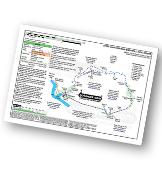
Route Summary:
Balmaha - The West Highland Way - Conic Hill - Burn of Mar - Garadhban Wood - Creity Hall - Milton of Buchanan - Balmaha
|
Vital Statistics:
| Length: | 7 miles (11 km) |
| Ascent: | 2,534ft (772m) |
| Time: | 5 hrs |
| Grade: |  |
|
Vital Statistics:
| Length: | 7.75 miles (12.5 km) |
| Ascent: | 3,180ft (969m) |
| Time: | 6 hrs |
| Grade: | |

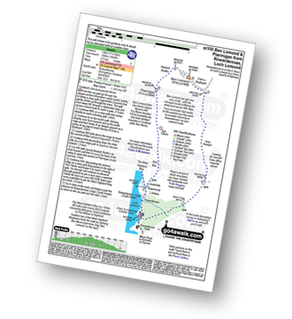
Route Summary:
Rowardennan - Loch Lomond - Sron Aonaich - Ben Lomond - Sron Aonaich - The West Highland Way - Rowardennen - Loch Lomond.
|
Vital Statistics:
| Length: | 7.5 miles (12 km) |
| Ascent: | 3,426ft (1,044m) |
| Time: | 6.25hrs |
| Grade: | |
Route Summary:
Rowardennan - Loch Lomond - Sron Aonaich - Ben Lomond - Ptarmigan - Tom Fithich - The West Highland Way - Rowardennen - Loch Lomond.
|
Vital Statistics:
| Length: | 7.25 miles (11.5 km) |
| Ascent: | 1,894ft (577m) |
| Time: | 4½ hrs |
| Grade: | |
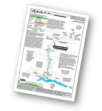
Route Summary:
Kirk Logie - Bridge of Allan - Yellow Craig Wood - Dumyat - Glen Menstrie - Lossburn Reservoir - Kirk Logie - Bridge of Allan.
|
Vital Statistics:
| Length: | 5.25 miles (8.5 km) |
| Ascent: | 2,117ft (645m) |
| Time: | 4 hrs |
| Grade: | |
Route Summary:
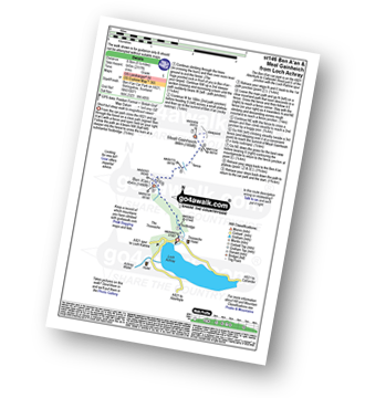
Ben A'an Forestry Commision Car Park - Loch Achray - The Trossachs - Woodland - Ben A'an - Meall Gainmheich - Ben A'an Forestry Commision Car Park - Loch Achray.
|
Vital Statistics:
| Length: | 2.5 miles (4 km) |
| Ascent: | 1,329ft (405m) |
| Time: | 2½ hrs |
| Grade: |  |

Route Summary:
Ben A'an Forestry Commision Car Park - Loch Achray - The Trossachs - Woodland - Ben A'an - Woodland - Ben A'an Forestry Commision Car Park - Loch Achray.
|
Vital Statistics:
| Length: | 5.25 miles (8.5 km) |
| Ascent: | 1,165ft (355m) |
| Time: | 3½ hrs |
| Grade: |  |
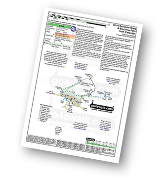
Route Summary:
Callander - Callander Craig - Bracklinn Falls Car Park - Keltie Water - Bracklinn Falls - Woodland - Callander
|
Vital Statistics:
| Length: | 6.25 miles (9.5 km) |
| Ascent: | 2,681ft (817m) |
| Time: | 5 hrs |
| Grade: | |

Route Summary:
Falls of Leny - Car Park NW of Falls of Leny - The Rob Roy Way - Garbh Uisge - Coireachchrombie - Stank - Stank Glen - Bealach Nan Corp - Coire na Fuaire - Gualainn Buidhe - Mullach Buidhem - Ben Ledi - Meal Odher - Creag Ghornm Car Park - Falls of Leny
|
Vital Statistics:
| Length: | 8.75 miles (14 km) |
| Ascent: | 3,499ft (1,051m) |
| Time: | 6.75hrs |
| Grade: |  |

Route Summary:
Arrochar - Loch Long - Ardgarten Forest - Allt a' Bhalachain - Narnain Boulders - Core a' Bhalachain - Lochan a' Chlaidheimh - Bealach A Mhaim - Beinn Ime - Bealach A Mhaim - Lochan a' Chlaidheimh - Core a' Bhalachain - Narnain Boulders - Allt a' Bhalachain - Ardgarten Forest - Arrochar
|
Vital Statistics:
| Length: | 6 miles (9.5 km) |
| Ascent: | 3,216ft (980m) |
| Time: | 5½ hrs |
| Grade: | |

Route Summary:
Arrochar - Loch Long - Argyle Forest - Creag An Fhithich - Cruach Nam Miseag - The Spearhead - Beinn Narnain - Yawning Crags - Bealach A Mhaim - Lochan a' Chlaidheimh - Core a' Bhalachain - Narnain Boulders - Allt a' Bhalachain - Andgarten Forest - Loch Long - Arrochar
|
Vital Statistics:
| Length: | 7.5 miles (11.5 km) |
| Ascent: | 3,344ft (1,019m) |
| Time: | 6 hrs |
| Grade: | |

Route Summary:
Arrochar - Loch Long - Argyll Forest Park - Adgarten Forest - Allt a' Bhalachain - Narnain Boulders - The Cobbler (Ben Arthur) (NE Top) - The Cobbler (Ben Arthur) - Lochan a' Chlaidheimh - Coire a' Bhalachain - Narnain Boulders - Allt a' Bhalachain - Adgarten Forest - Argyll Forest Park - Arrochar - Loch Long.
|
Vital Statistics:
| Length: | 1.5 miles (2.5 km) |
| Ascent: | 542ft (165m) |
| Time: | 1.25hrs |
| Grade: |  |

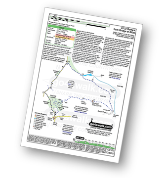
Route Summary:
Inversnaid - Inversnaid Hotel - Arklet Falls - Loch Lomond - The West Highland Way - Leacainn Lasgair - Cladachbeag - Inversnaid Hotel - Inversnaid
|
Vital Statistics:
| Length: | 12.25 miles (19.5 km) |
| Ascent: | 3,305ft (1,007m) |
| Time: | 7.75hrs |
| Grade: | |

Route Summary:
Culter Allers Farm - Culter Fell - Moss Law - Holm Nick - Gathersnow Hill - Hillshaw Head - Coomb Dod - Dod Hill - Hudderstone - Lea Gill - Culter Water - Culter Allers Farm
Not familiar with the area around G43?
See these 30 nearest walks to UK Postcode G43 on a google map
|
Vital Statistics:
| Length: | 7.5 miles (12 km) |
| Ascent: | 1,699ft (518m) |
| Time: | 4½ hrs |
| Grade: | |
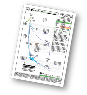
Route Summary:
Culter Allers Farm - Culter Fell - Moss Law - Holm Nick - Culter Water - Coulter Reservoir - Culter Waterhead - Culter Allers Farm
|
Vital Statistics:
| Length: | 9 miles (14.5 km) |
| Ascent: | 3,502ft (1,067m) |
| Time: | 6.75hrs |
| Grade: | |

Route Summary:
Inveruglas Power Station - Loch Lomond - A82 - Inveruglas Water - Loch Sloy Access Road - Lag Dubh - Ben Vorlich (The Arrochar Alps) - Ben Vorlich (The Arrochar Alps) (North Top) - Lag Dubh - Loch Sloy Access Road - Inveruglas - Loch Lomond.
|
Vital Statistics:
| Length: | 7.5 miles (12 km) |
| Ascent: | 3,101ft (945m) |
| Time: | 6 hrs |
| Grade: | |
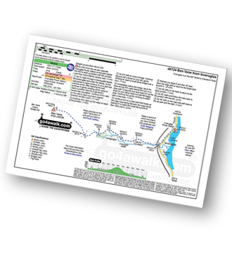
Route Summary:
Inveruglas Power Station - Loch Lomond - Loch Sloy Hydro Electric Sub-station - Inveruglas Water - Coiregrogain - Ben Vane - Coiregrogain - Inveruglas Water - Loch Sloy Hydro Electric Sub-station - Inveruglas Power Station - Loch Lomond.
|
Vital Statistics:
| Length: | 6.25 miles (10 km) |
| Ascent: | 1,848ft (563m) |
| Time: | 4.25hrs |
| Grade: | |

Route Summary:
Strathyre - River Balvag - Strathyre Forest - An Sidhean - Beinn an t-Sidhein - Beinn Luidh - Buachaille Breige - Stroneslaney - Baileful - Strathyre
|
Vital Statistics:
| Length: | 13.75 miles (22 km) |
| Ascent: | 3,206ft (977m) |
| Time: | 8.25hrs |
| Grade: |  |
Route Summary:
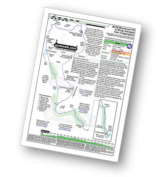
Craigengillan - Craigengillan Bridge - Galloway Forest Park - Polifferie Burn - Poldores Burn - Tup Knowe - Soms Knowe - Scar Knowe - Moorbrock Farm - Poltie Burn - Green Hill (Moorbrock) - Moorbrock Hill - Moorbrock Hill (North Top) - Luke's Stone - Keoch Rig - Deil's Putting Stone - Chapman's Cleugh - Windy Standard - Trostan Hill - Dugland - Clennoch Bothy - Green Hill (Moorbrock) - Craigengillan
|
Vital Statistics:
| Length: | 6.25 miles (10 km) |
| Ascent: | 2,091ft (637m) |
| Time: | 4½ hrs |
| Grade: | |
Route Summary:
Durisdeer - The Well Path - Well Hill - Penbane - Black Hill - Roman Fortlet - Roman Road - Durisdeer
|
Vital Statistics:
| Length: | 9.75 miles (15.5 km) |
| Ascent: | 2,881ft (878m) |
| Time: | 6½ hrs |
| Grade: | |

Route Summary:
Craigengillan - Craigengillan Bridge - Galloway Forest Park - Polifferie Burn - Poldores Burn - Tup Knowe - Soms Knowe - Scar Knowe - Moorbrock Farm - Poltie Burn - Green Hill (Moorbrock) - Poldores Burn - Beninne Gairy - Beninner - Nick of The Lochans - Cairnsmore of Carsphairn - Green Hill (Moorbrock) - Craigengillan
|
Vital Statistics:
| Length: | 9.5 miles (15 km) |
| Ascent: | 3,673ft (1,119m) |
| Time: | 7.25hrs |
| Grade: | |
Route Summary:
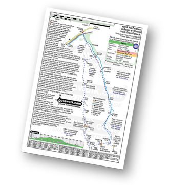
Glen Falloch - River Falloch - Sron Garbh - Coire Elch - Twistin Hill - The Castle - An Caisteal (Glen Falloch) - Bealach Buidhe - Beinn a' Chroin - Beinn a' Chroin (East Top) - River Falloch - Core Earb - Glen Falloch
|
Vital Statistics:
| Length: | 2.75 miles (4.5 km) |
| Ascent: | 82ft (25m) |
| Time: | 1 hrs |
| Grade: | |

|
Vital Statistics:
| Length: | 13 miles (22 km) |
| Ascent: | 3,823ft (1,165m) |
| Time: | 8 hrs |
| Grade: | |

Route Summary:
Forrest Lodge - Galloway Forest Park - Fore Bush - Polharrow Burn - Lumford Burn - Craignelden - Craigrine - Corserine - Carlin's Cairn - Corserine - Millfire - Milldown - Rhinns of Kells - Meikle Millyea - Meikle Lump - Burnhead - Forrest Lodge - Galloway Forest Park.
|
Vital Statistics:
| Length: | 8.75 miles (14 km) |
| Ascent: | 3,236ft (986m) |
| Time: | 6½ hrs |
| Grade: | |
Route Summary:
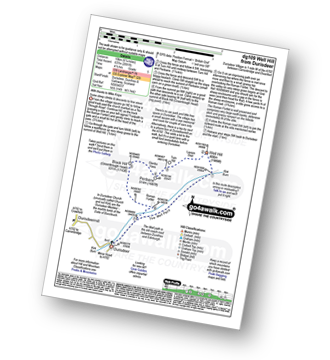
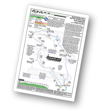
Capplegill - Blackhope Burn - Saddle Yoke - Under Saddle Yoke - Whirly Gill - Saddle Craigs - Harfell Rig - Hart Fell (Moffat) - Hartfell Craig - Falcon Craig - Upper Comb Craig - Swatte Fell - Nether Comb Craig - Black Craig - Hang Burn - Hang Gill - Capplegill
|
Vital Statistics:
| Length: | 9.75 miles (15.5 km) |
| Ascent: | 2,206ft (672m) |
| Time: | 5.75hrs |
| Grade: | |

Route Summary:
Parking Area A708 NE of Moffat - Moffat Water - Moffat Dale - The Southern Upland Way - Cornal Burn - Craigbeck Hope - Eskdalemuir - Wamphrey Burn - Sheepfold - Slecoth Burn - Croft Head - Corfthead Burn - Craiglochan Gardens - Parking Area.
|
Vital Statistics:
| Length: | 14.5 miles (23 km) |
| Ascent: | 3,781ft (1,152m) |
| Time: | 9 hrs |
| Grade: | |

Route Summary:
Parking Area A708 NE of Moffat - Moffat Water - Moffat Dale - The Southern Upland Way - Cornal Burn - Craigbeck Hope - Coomb Cairn - Scaw'd Fell - Eskdalemuir - Wamphrey Burn - Sheepfold - Slecoth Burn - Loch Fell - Croft Head - Corfthead Burn - Craiglochan Gardens - Parking Area.
|
Vital Statistics:
| Length: | 12.25 miles (19.5 km) |
| Ascent: | 2,750ft (838m) |
| Time: | 7½ hrs |
| Grade: | |

Route Summary:
Parking Area A708 NE of Moffat - Moffat Water - Moffat Dale - The Southern Upland Way - Cornal Burn - Craigbeck Hope - Coomb Cairn - Scaw'd Fell - Eskdalemuir - Wamphrey Burn - Sheepfold - Slecoth Burn - Croft Head - Corfthead Burn - Craiglochan Gardens - Parking Area.
|
Vital Statistics:
| Length: | 13.25 miles (21 km) |
| Ascent: | 2,586ft (788m) |
| Time: | 7.25hrs |
| Grade: | |

Route Summary:
Ettrick Water,Longhope Burn - Bught Hill - Bodesbeck Law - Nowtrig Head - Mid Rig (Bell Craig) - Salmongill Craig - Bald Craig - Bell Craig - Mirk Side - Andrewhinney Hill - Brockhope Head - Trowgrain Middle - Herman Law - Fala Grain - Back Beck - Brockhoperig - Ettrick Water
Not familiar with the area around G43?
See these 30 nearest walks to UK Postcode G43 on a google map


