|
Vital Statistics:
| Length: | 9mls (14.5km) |
| Ascent: | 3,502ft (1,067m) |
| Time: | 6¾hrs |
| Grade: |  |

Route outline for walk ab121:
Inveruglas Power Station - Loch Lomond - A82 - Inveruglas Water - Loch Sloy Access Road - Lag Dubh - Ben Vorlich (The Arrochar Alps) - Ben Vorlich (The Arrochar Alps) (North Top) - Lag Dubh - Loch Sloy Access Road - Inveruglas - Loch Lomond.
Peaks, Summits and Tops reached on this walk:
 1 Munro |
 0 Corbetts |
 0 Grahams |
 1 Murdo |
 0 Donalds |
 1 Scottish Marilyn |
 0 Bridgets |
Peak Bagging Statistics for this walk:
The highest point of this walk is Ben Vorlich (The Arrochar Alps) at 943m (3094ft). Ben Vorlich (The Arrochar Alps) is classified as a Munro (No. 230) and a Scottish Marilyn (170th highest in Scotland, 176th highest in the UK). Ben Vorlich (The Arrochar Alps) is also known as a Murdo (344th highest in Scotland). The summit of Ben Vorlich (The Arrochar Alps) is marked by a cairn 200m NNW of the Trig Point.
Completing this walk will also take you to the top of Ben Vorlich (The Arrochar Alps) (North Top) at 931m (3056ft). Ben Vorlich (The Arrochar Alps) (North Top) is Unclassified
You can find this walk and other nearby walks on these unique free-to-access Interactive Walk Planning Maps:
1:25,000 scale OS Explorer Map (orange/yellow covers):
1:50,000 scale OS Landranger Map (pink/magenta covers):
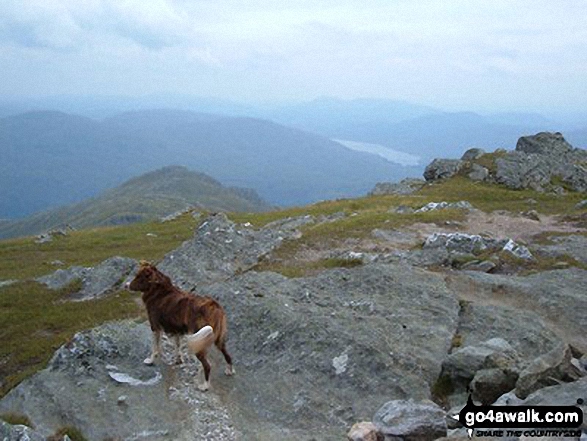
Some Photos and Pictures from Walk ab121 Ben Vorlich (Arrochar Alps) from Inveruglas
In no particular order . . .

The summits of Ben Vane (left) and Beinn Ime poking up through the clouds during a temperature inversion seen from Ben Vorlich (The Arrochar Alps)

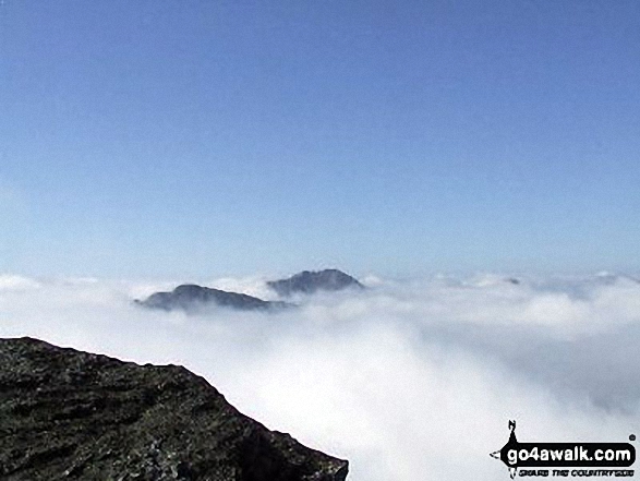
The summits of Ben Vane (left) and Beinn Ime poking up through the clouds during a temperature inversion seen from Ben Vorlich (The Arrochar Alps)

The summits of Ben Vane (left) and Beinn Ime poking up through the clouds during a temperature inversion seen from Ben Vorlich (The Arrochar Alps)
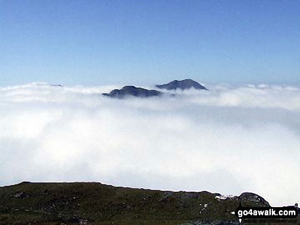
The summits of Ben Vane (left) and Beinn Ime poking up through the clouds during a temperature inversion seen from Ben Vorlich (The Arrochar Alps)
Send us your photographs and pictures from your walks and hikes
We would love to see your photographs and pictures from walk ab121 Ben Vorlich (Arrochar Alps) from Inveruglas. Send them in to us as email attachments (configured for any computer) along with your name and where the picture was taken to:
and we shall do our best to publish them.
(Guide Resolution = 300dpi. At least = 660 pixels (wide) x 440 pixels (high).)

You can also submit photos from walk ab121 Ben Vorlich (Arrochar Alps) from Inveruglas via our Facebook Page.
NB. Please indicate where each photo was taken.