   |
Vital Statistics:
| Length: | 5¼mls (8.5km) |
| Ascent: | 1,165ft (355m) |
| Time: | 3½hrs |
| Grade: |  |
Route outline for walk st144:
Callander - Callander Craig - Bracklinn Falls Car Park - Keltie Water - Bracklinn Falls - Woodland - Callander
Points of Interest/Notes on this walk:
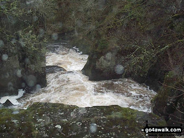
There used to be a wooden bridge across Bracklinn Falls but it was washed away during a storm in August, 2004. The water rose to about 3/4's of the way up the steps that lead down to the falls and a local farmer found fish some 15 feet up a tree! The bridge has never been found.
Peaks, Summits and Tops reached on this walk:
 0 Munros |
 0 Corbetts |
 0 Grahams |
 0 Murdos |
 0 Donalds |
 0 Scottish Marilyns |
 1 Bridget |
Peak Bagging Statistics for this walk:
The highest point of this walk is Callander Craig at 343m (1125ft). Callander Craig is known as a Scottish Bridget. The summit of Callander Craig is marked by a tall cairn.
You can find this walk and other nearby walks on these unique free-to-access Interactive Walk Planning Maps:
1:25,000 scale OS Explorer Map (orange/yellow covers):
1:50,000 scale OS Landranger Map (pink/magenta covers):
Some Photos and Pictures from Walk st144 Callander Craig from Bracklinn Falls
In no particular order . . .

Send us your photographs and pictures from your walks and hikes
We would love to see your photographs and pictures from walk st144 Callander Craig from Bracklinn Falls. Send them in to us as email attachments (configured for any computer) along with your name and where the picture was taken to:
and we shall do our best to publish them.
(Guide Resolution = 300dpi. At least = 660 pixels (wide) x 440 pixels (high).)

You can also submit photos from walk st144 Callander Craig from Bracklinn Falls via our Facebook Page.
NB. Please indicate where each photo was taken.


