Seventeen easy to follow walks from Great Langdale National Trust Campsite, Great Langdale, The Lake District, Cumbria, England
To reach Great Langdale National Trust Campsite, Great Langdale, in-car SatNav users should select the Latitude/Longitude (Lat Lon) screen and enter:
Lat = N54.44725 and Lon = W3.09177 or postcode: LA22 9JU
Not familiar with this campsite?
Seventeen easy to follow walks from Great Langdale National Trust Campsite, Great Langdale, The Lake District, Cumbria, England
Scroll down the list of walks below & click on each walk title (in blue) to locate it on the map above.

   |
Vital Statistics:
| Length: | 4.5 miles (7 km) |
| Ascent: | 1,902ft (580m) |
| Time: | 3½ hrs |
| Grade: |  |

Route Summary:
Great Langdale - The Old Dungeon Ghyll - Wall End Farm - Redacre Gill - Wrynose Fell - Pike of Blisco (Pike O' Blisco) - Red Tarn (Langdale) - Browney Gill - Oxendale Beck - Oxendale - Stool End Farm - The Old Dungeon Ghyll - Great Langdale


|
Vital Statistics:
| Length: | 8.5 miles (13.5 km) |
| Ascent: | 1,447ft (441m) |
| Time: | 4½ hrs |
| Grade: |  |

Route Summary:
Elterwater - Elterwater Bridge - Little Langdale - Little Langdale Tarn - Bridge End - Fell Foot Bridge - Castle Howe - Blea Tarn (Langdale) - Great Langdale - Oak Howe - Chapel Stile - Elterwater

|
Vital Statistics:
| Length: | 4.5 miles (7.5 km) |
| Ascent: | 2,645ft (806m) |
| Time: | 4½ hrs |
| Grade: | |

Route Summary:
Great Langdale - The New Dungeon Ghyll - Great Langdale - Stickle Ghyll - Stickle Tarn - Jack's Rake - The Langdale Pikes - Pavey Ark - Thunacar Knott - Harrison Stickle - Pike of Stickle (Pike O' Stickle) - Loft Crag - Mark Gate - The New Dungeon Ghyll - Great Langdale

|
Vital Statistics:
| Length: | 7 miles (11 km) |
| Ascent: | 1,976ft (602m) |
| Time: | 4½ hrs |
| Grade: | |

Route Summary:
Elterwater - Elterwater Bridge - Dale End - Lingmoor Fell - Fat Man's Agony (or Fat Man's Struggle) - Side Pike - Great Langdale - Side House Farm - The Cumbria Way - Oak Howe - Chapel Stile - Elterwater Bridge - Elterwater

|
Vital Statistics:
| Length: | 6.25 miles (10 km) |
| Ascent: | 1,968ft (600m) |
| Time: | 4.25hrs |
| Grade: | |
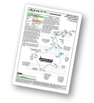
Route Summary:
Great Langdale - The Old Dungeon Ghyll - Wall End Farm - Redacre Gill - Wrynose Fell - Pike of Blisco (Pike O' Blisco) - Red Tarn (Langdale) - Wrynose Pass - Blea Tarn (Langdale) - The Old Dungeon Ghyll - Great Langdale

|
Vital Statistics:
| Length: | 7.75 miles (12.5 km) |
| Ascent: | 2,770ft (844m) |
| Time: | 5.75hrs |
| Grade: |  |

Route Summary:
Great Langdale - Old Dungeon Ghyll - Stool End - Oxendale Beck - Browney Gill - Red Tarn (Langdale) - Great Knott - Crinkle Crags (South Top) - Crinkle Crags (Long Top) - Crinkle Crags (Gunson Knott) - Shelter Crags - Shelter Crags (North Top) - Three Tarns - Earing Crag - White Stones - The Band - Oxendale - Stool End Farm - The Old Dungeon Ghyll - Great Langdale

|
Vital Statistics:
| Length: | 7.25 miles (11.5 km) |
| Ascent: | 3,046ft (928m) |
| Time: | 5.75hrs |
| Grade: | |

Route Summary:
Great Langdale - The New Dungeon Ghyll - Stickle Ghyll - Whitegill Crag - Blea Rigg - Sergeant Man - High Raise (Langdale) - The Langdale Pikes - Thunacar Knott - Pavey Ark - Harrison Stickle - Pike of Stickle (Pike O' Stickle) - Loft Crag - Mark Gate - The New Dungeon Ghyll - Great Langdale

|
Vital Statistics:
| Length: | 8.25 miles (13 km) |
| Ascent: | 2,924ft (891m) |
| Time: | 6 hrs |
| Grade: | |

Route Summary:
Great Langdale - The New Dungeon Ghyll - Stickle Ghyll - Stickle Tarn - North Rake - The Langdale Pikes - Pavey Ark - Thunacar Knott - Harrison Stickle - Loft Crag - Pike of Stickle (Pike O' Stickle) - Martcrag Moor - Stake Pass - The Cumbria Way - Stake Gill - Mickleden - Mickleden Beck - The New Dungeon Ghyll - Great Langdale

|
Vital Statistics:
| Length: | 8.75 miles (14 km) |
| Ascent: | 2,271ft (692m) |
| Time: | 5½ hrs |
| Grade: | |

Route Summary:
Great Langdale - Old Dungeon Ghyll - The Cumbria Way - Mickleden Beck - Mickleden (Langdale) - Rossett Beck - Rossett Pike - Little Gill Head - Black Crags (Langdale) - Stake Pass - The Cumbria Way - Stake Gill - Mickleden - Mickleden Beck - The New Dungeon Ghyll - Great Langdale

|
Vital Statistics:
| Length: | 11.25 miles (18 km) |
| Ascent: | 3,604ft (1,098m) |
| Time: | 7.75hrs |
| Grade: |  |

Route Summary:
Great Langdale - The Old Dungeon Ghyll - Stool End Farm - Oxendale - Oxendale Beck - Browney Gill - Red Tarn (Langdale) - Great Knott - Crinkle Crags (South Top) - Crinkle Crags (Long Top) - Crinkle Crags (Gunson Knott) - Shelter Crags - Shelter Crags (North Top) - Three Tarns - Climbers' Traverse (optional) - Flat Crag - Cambridge Crag - Bowfell Buttress - Bow Fell (Bowfell) - Bow Fell (Bowfell) (North Top) - Ore Gap - Angle Tarn (Langdale) - Rossett Pike - Rossett Beck - Mickleden - Mickleden Beck - The Cumbria Way - The Old Dungeon Ghyll - Great Langdale

|
Vital Statistics:
| Length: | 10 miles (16 km) |
| Ascent: | 4,007ft (1,221m) |
| Time: | 7½ hrs |
| Grade: | |

Route Summary:
Great Langdale - The Old Dungeon Ghyll - Wall End Farm - Redacre Gill - Wrynose Fell - Pike of Blisco (Pike O' Blisco) - Red Tarn (Langdale) - Cold Pike - Cold Pike (West Top) - Cold Pike (Far West Top) - Great Knott - Little Stand - Great Knott - Crinkle Crags (South Top) - Crinkle Crags (Long Top) - Crinkle Crags (Gunson Knott) - Shelter Crags - Shelter Crags - (North Top) - Three Tarns - Earing Crag - White Stones - The Band - Oxendale - Stool End Farm - The Old Dungeon Ghyll - Great Langdale

|
Vital Statistics:
| Length: | 9 miles (14.5 km) |
| Ascent: | 3,459ft (1,054m) |
| Time: | 6.75hrs |
| Grade: | |

Route Summary:
Great Langdale - Old Dungeon Ghyll - The Cumbria Way - Mickleden Beck - Mickleden (Langdale) - Rossett Beck - Rossett Pike - Angle Tarn (Langdale) - Esk Hause - Esk Pike - Ore Gap - Bow Fell (Bowfell) (North Top) - Bow Fell (Bowfell) - Bowfell Buttress - Cambridge Crag - Flat Crag - Climbers' Traverse (optional) - Three Tarns - Earing Crag - White Stones - The Band - Oxendale - Stool End Farm - The Old Dungeon Ghyll - Great Langdale

|
Vital Statistics:
| Length: | 9 miles (14.5 km) |
| Ascent: | 3,387ft (1,032m) |
| Time: | 6.75hrs |
| Grade: | |

Route Summary:
Great Langdale - The Old Dungeon Ghyll - Oxendale - Oxendale Beck - Red Tarn (Langdale) - Great Knott - Crinkle - Crags (South Top) - Bad Step - Crinkle Crags (Long Top) - Crinkle Crags (Gunson Knott) - Shelter Crags - Shelter Crags (North Top) - Three Tarns - Climbers' Traverse (optional) - Flat Crag - Cambridge Crag - Bowfell Buttress - Bow Fell (Bowfell) - Three Tarns - Earing Crag - White Stones - The Band - Stool End Farm - Mickleden Beck - Mickleden - The Old Dungeon Ghyll - Great Langdale

|
Vital Statistics:
| Length: | 10 miles (16 km) |
| Ascent: | 3,580ft (1,091m) |
| Time: | 7.25hrs |
| Grade: | |

Route Summary:
Great Langdale - The New Dungeon Ghyll - Stickle Ghyll - Stickle Tarn - North Rake - The Langdale Pikes - Pavey Ark - Thunacar Knott - Harrison Stickle - Loft Crag - Pike of Stickle (Pike o' Stickle) - Martcrag Moor - Stake Pass - Black Crags (Langdale) - Little Gill Head - Rossett Pike - Rossett Gill - The Cumbria Way - Mickleden - Mickleden Beck - The New Dungeon Ghyll - Great Langdale

|
Vital Statistics:
| Length: | 12.5 miles (20 km) |
| Ascent: | 4,684ft (1,428m) |
| Time: | 9.25hrs |
| Grade: |  |

Route Summary:
Great Langdale - The Old Dungeon Ghyll - The Cumbria Way - Mickleden Beck - Mickleden - Rossett Beck - Rossett Pike - Angle Tarn (Langdale) - Esk Hause - Great End - Ill Crag - Broad Crag - Scafell Pike - Esk Hause - Esk Pike - Ore Gap - Bow Fell (Bowfell) (North Top) - Bow Fell (Bowfell) - Bowfell Buttress - Cambridge Crag - Flat Crag - Climbers' Traverse (optional) - Three Tarns - The Band - Oxendale - Stool End Farm - The Old Dungeon Ghyll - Great Langdale

|
Vital Statistics:
| Length: | 11.25 miles (18 km) |
| Ascent: | 3,883ft (1,183m) |
| Time: | 8 hrs |
| Grade: | |

Route Summary:
Great Langdale - The Old Dungeon Ghyll - The Cumbria Way - Mickleden Beck - Rossett Gill - Rossett Pike - Angle Tarn (Langdale) - Esk Hause - Scafell Pike - Ill Crag - Broad Crag - Great End - Esk Hause - Angle Tarn - Rossett Gill - Mickleden - Mickleden Beck - The Cumbria Way - The Old Dungeon Ghyll - Great Langdale

|
Vital Statistics:
| Length: | 11.75 miles (19 km) |
| Ascent: | 4,680ft (1,426m) |
| Time: | 9 hrs |
| Grade: | |

Route Summary:
Great Langdale - The Old Dungeon Ghyll - Wall End Farm - Redacre Gill - Wrynose Fell - Pike of Blisco (Pike O' Blisco) - Red Tarn (Langdale) - Great Knott - Crinkle Crags (South Top) - Crinkle Crags (Long Top) - Crinkle Crags (Gunson Knott) - Shelter Crags - Shelter Crags (North Top) - Three Tarns - Climbers' Traverse (optional) - Flat Crag - Cambridge Crag - Bowfell Buttress - Bow Fell (Bowfell) - Bow Fell (Bowfell) (North Top) - Ore Gap - Angle Tarn (Langdale) - Rossett Pike - Rossett Beck - Mickleden - Mickleden Beck - The Cumbria Way - The Old Dungeon Ghyll - Great Langdale





