9 walks in The North York Moors
The North York Moors National Park is located in North Eastern England and wholly within the county of North Yorkshire.
Interactive Map of Walks in The North York Moors
![]() How to Load this interactive map: Due to usage restrictions, you must be Registered and Logged-On to go4awalk.com to view and use the interactive Google Map below. You do not need to purchase any credits, but you must be Registered and Logged-On.
How to Load this interactive map: Due to usage restrictions, you must be Registered and Logged-On to go4awalk.com to view and use the interactive Google Map below. You do not need to purchase any credits, but you must be Registered and Logged-On.

You can use these checkboxes to show only the grades of walk you are interested in:-
Nine easy-to-follow, circular, walk route maps in The North York Moors in Walk Grade Order (1 to 9)
See this list of walks, routes & maps in:
Grade Order | Length Order | Time Order | Walk Number or Start Location Order
NB. To reverse (toggle) this order, click Grade Order again
Scroll down the list of walks below & click on each walk title (in blue) to locate it on the map above.
   |
Vital Statistics:
| Length: | 5.25 miles (8.5 km) |
| Ascent: | 380 ft (116 m) |
| Time: | 2.25 hrs |
| Grade: |  |
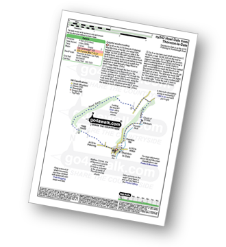
Route Summary:
Thornton-le-Dale - Hagg House - Howl Dale Wood - Howl Dale - Orchan Dale - Pexton Moor Plantation - Kirkdale Slack - Ellerburn - Thornton-le-Dale
|
Vital Statistics:
| Length: | 5 miles (8 km) |
| Ascent: | 689 ft (210 m) |
| Time: | 2½ hrs |
| Grade: |  |
Route Summary:
Hawnby - Hill End House - Moor Gate - Sportsman's Hall - Ladhill Beck - Pepper Hill - Easterside Hill - Wass House - Easterside Farm - Ladhill Beck - Hawnby
|
Vital Statistics:
| Length: | 4.5 miles (7 km) |
| Ascent: | 623 ft (190 m) |
| Time: | 2.25 hrs |
| Grade: | |

Route Summary:
Hutton-le-Hole - The Lund - Fairy Call Beck - High Cross Plain - Mary Magdalene Well - Lastingham - St Chad's Well - St Cedd's Well - Ings Beck - Hagg Wood - Spaunton - Grange Farm - Austin Head - Hutton-le-Hole
|
Vital Statistics:
| Length: | 8.75 miles (14 km) |
| Ascent: | 590 ft (180 m) |
| Time: | 3.75 hrs |
| Grade: |  |
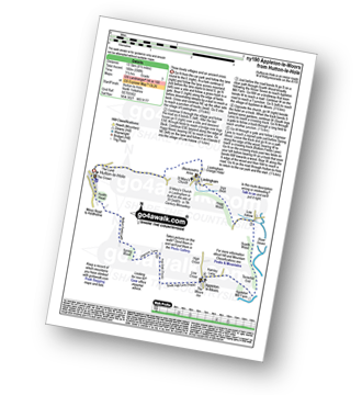
Route Summary:
Hutton-le-Hole - The Lund - Fairy Call Beck - High Cross Plain - Mary Magdalene Well - Lastingham - St Chad's Well - St Cedd's Well - Ings beck - Hagg Wood - Lower Askew - Birk Head - Scarth Wood - Tenterhill End - Appleton Mill Farm - The Tabular Hills Walk - Hamley Lane - Appleton-le-Moors - South Ings Lane (Track) - Ings Balk (Track) - Lingmoor Lane (Track) - Spring Wood - Bottom Fields Lane - Austin Head - Hutton-le-Hole
|
Vital Statistics:
| Length: | 6.5 miles (10.5 km) |
| Ascent: | 932 ft (284 m) |
| Time: | 3.25 hrs |
| Grade: | |
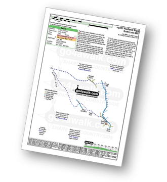
Route Summary:
Low Mill - Horn End Farm - Crow Wood - West Gill Beck - Westside Road (Track) - West Gill Head - Rudland Rigg - Dickon Howe - Monket House Bank (Track) - Monket House - Thorn Wath Bridge - Church Houses - High Mill - River Dove - Ferndale Nature Reserve - Low Mill
|
Vital Statistics:
| Length: | 8.5 miles (13.5 km) |
| Ascent: | 1,089 ft (332 m) |
| Time: | 4 hrs |
| Grade: | |

Route Summary:
Hutton-le-Hole - Lodge Road - Wheat Lund - Hutton Ridge - High Snapes - Loskey Beck - Loskey Ridge - Ana Cross - Spaunton Moor - Spring Heads Turn - Barker Slack - Lastingham Ridge - Lastingham - St Chad's Well - St Cedd's Well - Ings beck - Hagg Wood - Spaunton - Grange Farm - Austin Head - Hutton-le-Hole
|
Vital Statistics:
| Length: | 6.25 miles (10 km) |
| Ascent: | 1,355 ft (413 m) |
| Time: | 3.75 hrs |
| Grade: | |
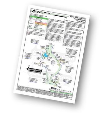
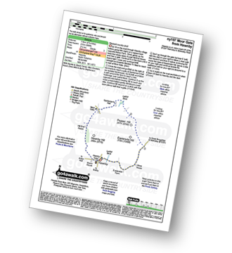
Route Summary:
Kilburn White Horse - Hoodhill Feld Plantation - Hood Hill Plantation - Hood Grange - Kennycow - High Cleavers Farm - Gormire Rigg - Gormire Lake - Southwoods Lodge - Garbutt Wood - The Cleveland Way - Whitestone Cliff - White Mare Crag - Great Relief Pot - Cliff Plantation - Sutton Brow - Sutton Bank - Knowlson's Drop - Roulston Scar - Ivy Scar - Kilburn White Horse
|
Vital Statistics:
| Length: | 8.75 miles (14 km) |
| Ascent: | 1,398 ft (426 m) |
| Time: | 4½ hrs |
| Grade: |  |
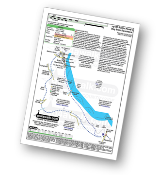
Route Summary:
Robin Hood's Bay - The Cleveland Way - Cowfield Hill - Boggle Hole - Stoupe Beck - Stoupe Bank Farm - Stoupebrow Cottage Farm - Ravenscar - Dismantled Railway - Stoupe Brow Farm - Home Farm - Brownside Farm - Howdale Wood - Alison Head Wood - Fyling Old Hall Farm - White House - Fylingthorpe - Robin Hood's Bay
|
Vital Statistics:
| Length: | 12.75 miles (20.5 km) |
| Ascent: | 1,056 ft (322 m) |
| Time: | 5.75 hrs |
| Grade: | |

Route Summary:
Hutton-le-Hole - Lodge Road - Wheat Lund - Hutton Ridge - High Snapes - Loskey Beck - Loskey Ridge - Ana Cross - Spaunton Moor - Spring Heads Turn - Barker Slack - Lastingham Ridge - Lastingham - St Chad's Well - St Cedd's Well - Ings beck - Hagg Wood - Lower Askew - Birk Head - Scarth Wood - Tenterhill End - Appleton Mill Farm - The Tabular Hills Walk - Hamley Lane - Appleton-le-Moors - South Ings Lane (Track) - Ings Balk (Track) - Lingmoor Lane (Track) - Spring Wood - Bottom Fields Lane - Austin Head - Hutton-le-Hole
See this list of walks, routes & maps in:
Grade Order | Length Order | Time Order | Walk Number or Start Location Order
NB. To reverse (toggle) this order, click Grade Order again


