12 easy-to-follow circular walk route maps of all grades in The Broads
The Broads National Park is the area of Norfolk and Suffolk that lies within the boundary of The Broads National Park.
Tap/mouse over a coloured circle (1-3 easy walks, 4-6 moderate walks, 7-9 hard walks) and click to select.
You can use these checkboxes to show only the grades of walk you are interested in:-
Scroll down the list of walks below & click on each walk title (in blue) to locate it on the map above.
See this list of walks, routes & maps in:
Grade Order | Length Order | Time Order | Walk Number or Start Location Order
NB. To reverse (toggle) this order, click Grade Order again
   |
Vital Statistics:
| Length: | 3.5 miles (5.5 km) |
| Ascent: | 91 ft (28 m) |
| Time: | 1½ hrs |
| Grade: |  |
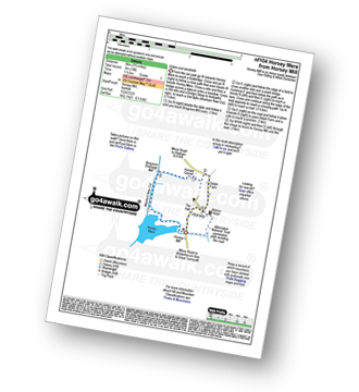
Route Summary:
Horsey Mill - Horsey Mere - Waxham New Cut - Brograve Drainage Mill - Horsey Corner - Horsey church - Horsey - National Trust Permissive Path - Horsey Mill
|
Vital Statistics:
| Length: | 7 miles (11 km) |
| Ascent: | 141 ft (43 m) |
| Time: | 3 hrs |
| Grade: | |

Route Summary:
Haddiscoe - Thorpe Road - Thorpe Hall - Haddiscoe Marshes - Thorpe Marshes - Thorpe and Haddiscoe Fleet - Haddiscoe Cut Bridge - Willow Farm - Marsh Farm - Lower Thurlton - Haddiscoe
|
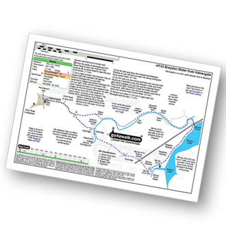
Vital Statistics:
| Length: | 9 miles (14.5 km) |
| Ascent: | 125 ft (38 m) |
| Time: | 3½ hrs |
| Grade: |  |

Route Summary:
Burgh Castle - Burgh Castle Roman Fort - The Angles Way - Breydon Water - Burgh Castle Marshes - Breydon Water Pump House - Fisher's Marshes - Humberstone Marshes - Breydon Bridge - Cobholm Island - Great Yarmouth - Southtown - Ganton Marshes - Bradwell Hall - Burgh Castle
|
Vital Statistics:
| Length: | 7.75 miles (12.5 km) |
| Ascent: | 135 ft (41 m) |
| Time: | 3 hrs |
| Grade: | |
Route Summary:
South Walsham Broad - Fleet Dike - Ward Marsh - St Benet's Abbey - River Bure - South Walsham Marshes - Thurne Mouth - Upton Marshes - Upton Black Drainage Mill - Ashby Oby Drainage & sawmill - Clippesby Mill - Upton Dyke - Palmer's Mill - Upton - Duckboards in Upton Broad and Marshes Nature Reserve - Cargate Green - Pilson Green - South Walsham Broad
|
Vital Statistics:
| Length: | 6 miles (9.5 km) |
| Ascent: | 128 ft (39 m) |
| Time: | 2½ hrs |
| Grade: | |

Route Summary:
Winterton-on-Sea - Winterton Dunes National Nature Reserve - South Wood - Decay Wood - White House Farm - East Somerton - Winterton-on-Sea
|
Vital Statistics:
| Length: | 4.25 miles (6.5 km) |
| Ascent: | 157 ft (2,348 m) |
| Time: | 1.75 hrs |
| Grade: | |

Route Summary:
Worstead - Worstead Belt - Worstead Hall Farm - Chestnut Belt - Gothic Wood - Upper Street - Carman's Lane - Mucklefield Plantation - Dairyhouse Barn - Green Lane - Berard's Road - Worstead
|
Vital Statistics:
| Length: | 9.25 miles (14.5 km) |
| Ascent: | 229 ft (70 m) |
| Time: | 3½ hrs |
| Grade: | |
Route Summary:
Halvergate - The Weavers Way - Wickhampton Marshes - Berney Arms Railway Station - Berney Arms Mill - Berney Arms Reach - Breydon Water - Reedham Marshes - Beighton Marshes - Breydon Pump - The Fleet - Halvergate
|
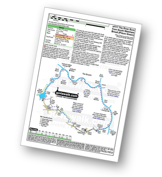
Vital Statistics:
| Length: | 9 miles (14.5 km) |
| Ascent: | 151 ft (46 m) |
| Time: | 3½ hrs |
| Grade: |  |

Route Summary:
Winterton-on-Sea - Winterton Dunes National Nature Reserve - South Wood - Bramble Hill - Crinkle Hill - Horsey - Horsey Mill - Hundred Stream - Martham Broad National Nature Reserve - Martham Broad - West Somerton Mill - West Somerton - East Somerton - Winterton-on-Sea
|
Vital Statistics:
| Length: | 12.5 miles (20 km) |
| Ascent: | 347 ft (106 m) |
| Time: | 4.75 hrs |
| Grade: | |

Route Summary:
Reedham - Reedham Chain Ferry - Wherryman's Way - Reedham Drainage Mill - River Yare - Reedham Marshes - Seven Mile House - Polkey's Drainage Mill - Cadge's Drainage Mill - Berney Arms Reach - Berney Arms Mill - The Weavers Way - Berney Marshes - Berney Arms Railway Station - Stone's Drainage Mill - Wickhampton Marshes - Wickhampton - Halvergate Road - Reedham Parish Church - Damgate - Holly Farm Road - Reedham
|
Vital Statistics:
| Length: | 5.5 miles (9 km) |
| Ascent: | 670 ft (204 m) |
| Time: | 2.75 hrs |
| Grade: | |
Route Summary:
Sheringham - The Peddars Way and Norfolk Coast Path - Life Boat Station - Golf Course - Coast Watch Lookout Station - Sheringham Park - Oak Wood - Gazebo View Point - Sheringham Wood - Sheringham Temple - Hall Farm - Upper Sheringham - Sheringham
|
Vital Statistics:
| Length: | 5.25 miles (8.5 km) |
| Ascent: | 43 ft (13 m) |
| Time: | 2 hrs |
| Grade: | |
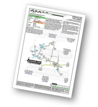
Route Summary:
Ludham - Lovers Lane - Whitegates - How Hill National Nature Reserve - River Ant - Turf Fen Drainage Mill - Boardman's Drainage Mill - Clayrack Drainage Mill - The Mill House - Crome's Farm - Crome's Broad - Grove Farm - Waterpiece Lane - Catfield Road - Ludham
|
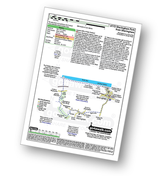
Vital Statistics:
| Length: | 7.25 miles (11.5 km) |
| Ascent: | 197 ft (60 m) |
| Time: | 3 hrs |
| Grade: | |

Route Summary:
Somerleyton - The Angles Way - Somerleyton Park - Lound - Green Lane - Waddling Lane - The Angles Way - Wicker Well - Waddling Wood - Somerleyton Railway Station - Somerleyton
See this list of walks, routes & maps in:
Grade Order | Length Order | Time Order | Walk Number or Start Location Order
NB. To reverse (toggle) this order, click Grade Order again


