36 walks in Northumberland
Northumberland National Park is located in North East England and wholly within the county of Northumberland.
Interactive Map of Walks in Northumberland
![]() How to Load this interactive map: Due to usage restrictions, you must be Registered and Logged-On to go4awalk.com to view and use the interactive Google Map below. You do not need to purchase any credits, but you must be Registered and Logged-On.
How to Load this interactive map: Due to usage restrictions, you must be Registered and Logged-On to go4awalk.com to view and use the interactive Google Map below. You do not need to purchase any credits, but you must be Registered and Logged-On.

You can use these checkboxes to show only the grades of walk you are interested in:-
Thirty-six easy-to-follow, circular, walk route maps in Northumberland in Walk Grade Order
See this list of walks, routes & maps in:
Grade Order | Length Order | Time Order | Walk Number or Start Location Order
NB. To reverse (toggle) this order, click Grade Order again
Scroll down the list of walks below & click on each walk title (in blue) to locate it on the map above.
   |
Vital Statistics:
| Length: | 8.25 miles (13 km) |
| Ascent: | 1,460 ft (445 m) |
| Time: | 4½ hrs |
| Grade: |  |

Route Summary:
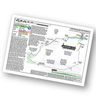
Housteads Visitor Centre - Chapel Hill - Housesteads - Vercovicium Fort - The Hadrian's Wall Path - Housesteads Crags - Cuddy's Crag - The Pennine Way - Hotbank Crags - Hotbank - Crag Lough - Highshield Crags - Steel Rigg - Peel Crags - Peel - Once Brewed - Brackies Burn - Smith's Shield - Causeway House - Vindolanda Roman Fort - Chesterholm - Barcombe - East Crindledykes Farm - Green Brae - Little Shield - Deafley Rigg - Housteads Visitor Centre
|
Vital Statistics:
| Length: | 7 miles (11 km) |
| Ascent: | 2,022 ft (616 m) |
| Time: | 4½ hrs |
| Grade: | |

Route Summary:
Harthope Burn Valley - Hawsen Burn Parking Area - New Burn - Scald Hill - The Cheviot - Scald Hill - New Burn - Hawsen Burn Parking Area.
|
Vital Statistics:
| Length: | 4 miles (6.75 km) |
| Ascent: | 732 ft (223 m) |
| Time: | 2½ hrs |
| Grade: |  |

Route Summary:
Harbottle Castle - Drake Stone - West Wood - Harbottle Lake - Angryhaugh - Low Winton - River Coquet - Harbottle - Harbottle Castle
|
Vital Statistics:
| Length: | 9.5 miles (15 km) |
| Ascent: | 1,378 ft (420 m) |
| Time: | 4.75 hrs |
| Grade: | |
Route Summary:
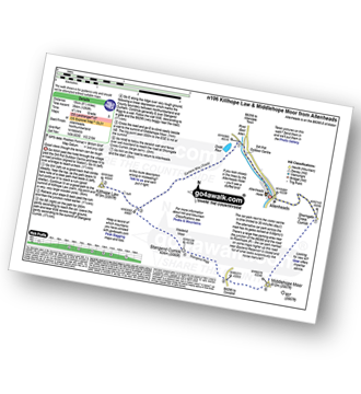
Allenheads - Dirt Pots - The Weardale Way - Killhope Law - Stangend Currick - Middlehope Moor - Shorngate Cross - Allenheads
|
Vital Statistics:
| Length: | 7.5 miles (12 km) |
| Ascent: | 1,257 ft (383 m) |
| Time: | 4½ hrs |
| Grade: | |

Route Summary:
Wooler - The St Cuthbert's Way - Waud House - Kenterdale Hill - Wooler Common - Switcher Wood - Earlhillhead Farm - Carey Burn - Careyburn Bridge - Harthope Burn - Colgate Water (High Level Route) - Happy Valley - Middleton Old Town - North Middleton - Colgate Mill - Colgate Water - Earle Mill - Wooler Water - Wooler
|
Vital Statistics:
| Length: | 7.5 miles (12 km) |
| Ascent: | 1,753 ft (534 m) |
| Time: | 4½ hrs |
| Grade: | |

Route Summary:
Rowhope Burn Bridge - River Coquet - Hindside Knowe - The Street - Swineside Law - Black Braes - Windy Rigg Top - Windy Gyle - Trows Burn - Rowhope Burn - Rowhope Burn Bridge
|
Vital Statistics:
| Length: | 7.25 miles (11.5 km) |
| Ascent: | 1,165 ft (355 m) |
| Time: | 3.75 hrs |
| Grade: |  |
Route Summary:
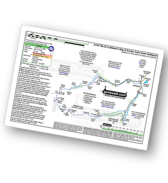
Hethpool - The St Cuthbert's Way - Elsdon Burn - Elsdonburn Farm - Shank's Sike - Scaldhill Shank - Tom's Knowe - Tuppie's Sike - Eccles Cairn - England / Scotland Border - The Pennine Way - Tuppie's Grave - The Tongue - Maddie's Well - Madam Law - Wideopen Head - Trowup Burn - Trowupburn - College Valley - College Burn - Hethpool
|
Vital Statistics:
| Length: | 10.5 miles (17 km) |
| Ascent: | 2,614 ft (797 m) |
| Time: | 6½ hrs |
| Grade: |  |

Route Summary:
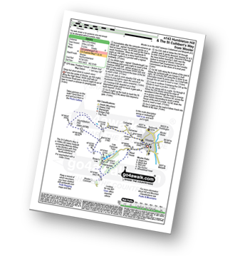
Harthope Burn Valley - Cold Law - Broadhope Hill - Scald Hill - The Cheviot - The Pennine Way - Harthope Burn - Langleeford Hope - Langleeford - Harthope Burn Valley
|
Vital Statistics:
| Length: | 4.75 miles (7.5 km) |
| Ascent: | 985 ft (300 m) |
| Time: | 2.75 hrs |
| Grade: | |
Route Summary:
Wooler - Gallowlaw Gallowlaw Hill - Humbleton - Humbleton Hill - Brown's Law - Wooler Common And Woodland Park - Wooler
|
Vital Statistics:
| Length: | 8.5 miles (13.5 km) |
| Ascent: | 2,114 ft (644 m) |
| Time: | 5½ hrs |
| Grade: |  |

Route Summary:
Harthope Burn Valley - Hawsen Burn Parking Area - New Burn - Scald Hill - The Cheviot - Cairn Hill (Scotsmans Cairn) - Harthope Burn - Hrthope Linn - Langleeford Hope - Cat Loup - Ray Burn - Langleeford Farm - Hawsen Burn Parking Area.
|
Vital Statistics:
| Length: | 8.5 miles (13.5 km) |
| Ascent: | 804 ft (245 m) |
| Time: | 4 hrs |
| Grade: | |

Route Summary:
Haltwhistle - Wydon Farm - Wydon Eals Farm - River South Tyne - Featherstone Castle - Lambley Viaduct Nature Trail - Thorneyhole Wood - Featherstone Rowfoot - Park Village - Broomhouse Farm - Haltwhistle
|
Vital Statistics:
| Length: | 3.75 miles (6 km) |
| Ascent: | 700 ft (213 m) |
| Time: | 2.25 hrs |
| Grade: | |
Route Summary:
Careyburn Bridge - Carey Burn - Switcher Wood - Earlhillhead Farm - Wooler Common - Carey Burn - Careyburn Bridge
|
Vital Statistics:
| Length: | 5.25 miles (8.5 km) |
| Ascent: | 512 ft (156 m) |
| Time: | 2½ hrs |
| Grade: | |

Route Summary:
Bamburgh - Bamburgh Castle - The Wynding - Harkess Rocks - Bamburgh Lighthouse - Blackrocks Point - Hare Law - Kittling Hill - Budle Point - Heather Cottages - Kiln Point - Budle - East Hill - Warren Camping and Caravan Park - Drawkiln Hill - Shada Plantation - Gallinheugh Bank - Bamburgh
|
Vital Statistics:
| Length: | 9.5 miles (15 km) |
| Ascent: | 2,009 ft (612 m) |
| Time: | 5½ hrs |
| Grade: | |

Route Summary:
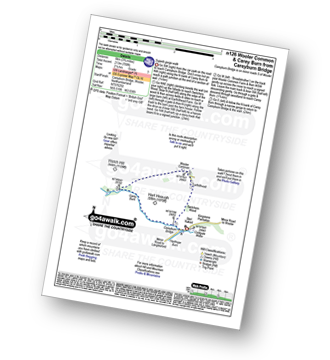
Wedder Leap - River Coquet - Rowhope Burn - Trows Burn - Windy Gyle - The Pennine Way - Hazely Law - Hepden Burn - Clennel St - Middle Hill - Fairhaugh - Barrow Burn - Barrowburn.
|
Vital Statistics:
| Length: | 8.5 miles (13.5 km) |
| Ascent: | 1,450 ft (442 m) |
| Time: | 4.75 hrs |
| Grade: | |
Route Summary:
Rothbury - The St Oswald's Way - Whitton - Whittondean Farm - Garleigh Moor - Lordenshaws Car Park - The Beacon - Dove Crag - Old stell Crag - Simonside - Bob Pyle's Studdie - Joe's Wood - Great Tosson - The Old Pumphouse - River Coquet - Anton's Letch - Rothbury
|
Vital Statistics:
| Length: | 4.75 miles (7.5 km) |
| Ascent: | 735 ft (225 m) |
| Time: | 2½ hrs |
| Grade: | |

|
Vital Statistics:
| Length: | 9.5 miles (15.5 km) |
| Ascent: | 2,800 ft (853 m) |
| Time: | 6½ hrs |
| Grade: | |

Route Summary:
Harthope Burn Valley - Hawsen Burn Parking Area - New Burn - Scald Hill - The Cheviot - Cairn Hill (Scotsmans Cairn) - Harthope Burn - Comb Fell - Hedgehope Hill - Long Crags - Housey Crags - Hawsen Burn Parking Area.
|
Vital Statistics:
| Length: | 17 miles (27 km) |
| Ascent: | 3,463 ft (1,055 m) |
| Time: | 9½ hrs |
| Grade: |  |
Route Summary:
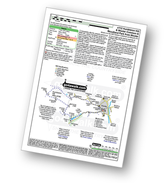
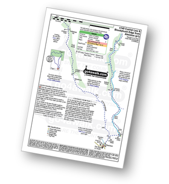
Alwinton - River Alwin - Alwindale - Kidland Forest - Yoke Burn - Cushat Law - Bloodybush Edge - Uswayford Farm - Usway Burn - Nettlehope Hill - Flesh Shank - Wholehope - Clennell Street - Howedon Burn - Alwinton
|
Vital Statistics:
| Length: | 5 miles (8 km) |
| Ascent: | 1,021 ft (311 m) |
| Time: | 3 hrs |
| Grade: | |

Route Summary:
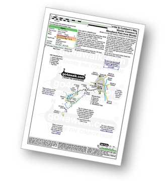
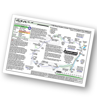
Hethpool - The St Cuthbert's Way - White Hill (Hethpool) - East Laddie's Knowe - Laddie's Knowe or Betsy's Cairn - Black Bog (Haddon Hill) - Haddon Hill - Ring Chesters - Elsdonburn Farm - Elsdon Burn - The St Cuthbert's Way - Hethpool
|
Vital Statistics:
| Length: | 5.5 miles (9 km) |
| Ascent: | 1,138 ft (347 m) |
| Time: | 3½ hrs |
| Grade: | |
Route Summary:
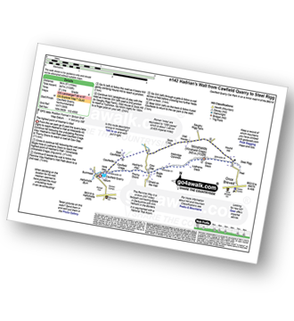
Cawfield Quarry Car Park - Hadrian's Wall - The Pennine Way - The Hadrian's Wall Path - Cawfield Crags - Thorny Doors - Caw Gap - Bogle Hole - Lodhams Slack - Winshields (Winshield Crags) - Green Slack - Steel Rigg - Hound Hill - Melkridge Common - East Cawfields - Cawfields - Cawfield Quarry Car Park
|
Vital Statistics:
| Length: | 5.75 miles (9 km) |
| Ascent: | 1,214 ft (370 m) |
| Time: | 3½ hrs |
| Grade: | |
Route Summary:
Wooler - Gallowlaw Gallowlaw Hill - Humbleton - Humbleton Hill - Brown's Law - Wooler Common and Woodland Park - The St Cuthbert's Way - Kenterdale Hill - Waud House - Wooler
|
Vital Statistics:
| Length: | 10.5 miles (16.5 km) |
| Ascent: | 2,244 ft (684 m) |
| Time: | 6 hrs |
| Grade: | |

Route Summary:
Alnham - Salter's Road - Northfieldhead - White Gate - High Knowes - Ewartly Shank - Shank Burn - Little Dod - Shill Moor - Breamish Valley - Meggrim's Knowe - Alnhammoor Farm - Rowhope Burn - Leafield Edge - Deb Cleugh - Northfieldhead - Alnham
|
Vital Statistics:
| Length: | 6.5 miles (10.5 km) |
| Ascent: | 1,043 ft (318 m) |
| Time: | 3½ hrs |
| Grade: | |

Route Summary:
Wooler - The St Cuthbert's Way - Waud House - Kenterdale Hill - Wooler Common - Switcher Wood - Earlhillhead Farm - Carey Burn - Careyburn Bridge - Harthope Burn - Colgate Water (Low Level Route) - Skirl Naked - Grimping Haugh - Broom Crook Plantation - Happy Valley - Careyburn Bridge - Colgate Mill - Earle Mill - Wooler Water - Wooler
|
Vital Statistics:
| Length: | 12.75 miles (20.5 km) |
| Ascent: | 1,759 ft (536 m) |
| Time: | 6½ hrs |
| Grade: | |

Route Summary:
Allenheads - Dirt Pots - The Weardale Way - Killhope Law - Shivery Hill - Carshield Moor - Scum Hill - Hartley Moor - Nan Davison's Cleugh - Philipson's Fold - Knockshield Moor - Black Way (Track) - Swinhope Shield - High Knock Shield - Knock Shield - Knockburn Farm - River East Allen - Low Sipton Shield - Sipton Terrace - Teedham Green - Corn Mill - Low Huntwell - Dirt Pots - Allenheads
|
Vital Statistics:
| Length: | 11.25 miles (18 km) |
| Ascent: | 2,311 ft (704 m) |
| Time: | 6½ hrs |
| Grade: | |

Route Summary:
Wedder Leap - River Coquest - Rowhope Burn - Hindside Knowe - The Street - Swineside Law - Black Braes - Windy Rigg Top - Windy Gyle - Hazely Law - Usway Burn - Middle Hill - Fairhaugh - Barrow Burn - Barrowburn.
|
Vital Statistics:
| Length: | 7.5 miles (12 km) |
| Ascent: | 1,316 ft (401 m) |
| Time: | 4 hrs |
| Grade: | |

Route Summary:
Hethpool - The St Cuthbert's Way - White Hill (Hethpool) - East Laddie's Knowe - Laddie's Knowe or Betsy's Cairn - Black Bog (Haddon Hill) - Haddon Hill - Ring Chesters - Sheepfold - Eccles Cairn - England / Scotland Border - Elsdonnurn Farm - Elsdon Burn - The St Cuthbert's Way - Hethpool
|
Vital Statistics:
| Length: | 3.25 miles (5 km) |
| Ascent: | 525 ft (160 m) |
| Time: | 1.75 hrs |
| Grade: |  |
Route Summary:
Wooler - The St Cuthbert's Way - Waud House - Kenterdale Hill - Wooler Common and Woodland Park - Wooler
|
Vital Statistics:
| Length: | 16.5 miles (26.5 km) |
| Ascent: | 3,144 ft (958 m) |
| Time: | 9.25 hrs |
| Grade: | |

Route Summary:
Hethpool - College Valley - Whitehall - Fleehope - Mounthooly - Birnie Brae - The Pennine Way - Red Cribs - Auchope Cairn - Cairn Hill - The Cheviot - Scald Hill - Goldcleugh - Lambden Burn - Dunsdale - Coldburn - Southernknowe - Whitehall - Hethpool
|
Vital Statistics:
| Length: | 10.25 miles (16.5 km) |
| Ascent: | 1,182 ft (360 m) |
| Time: | 5 hrs |
| Grade: | |

Route Summary:
Wooler - The St Cuthbert's Way - Weetwood Bank - Weetwood Moor - River Till - Weetwood Bridge - Weetwood Hall - Weetwood Hill - Broomy Knowe - Shepherds House - Dod Law (Doddington Moor) - Doddington Moor - Doddington - River Till - St Cuthbert's Bridge - Milfield Plain - River Glen - Bridge End - Bowchester - Low Humbleton - Gallowlaw Hill - Gallowlaw - Wooler
|
Vital Statistics:
| Length: | 13.5 miles (21.5 km) |
| Ascent: | 2,504 ft (763 m) |
| Time: | 7½ hrs |
| Grade: | |

Route Summary:
Alwinton - Hosedon Burn - The Creel - Clennelstreet Farm - Clennell Street (Track) - Cross Dyke - Uplaw Knowe - Hare Sheds - Wholehope - Wholehope Knowe - Saughy Hill - Nettlehope Hill - Usway Burn - The Middle - Middle Hill - Fairhaugh - Hoseden Law - The Castles - Batailshiel Haugh - Shillmoor - The Knocks - Pass Peth - Alwinton
|
Vital Statistics:
| Length: | 8.5 miles (13.5 km) |
| Ascent: | 988 ft (301 m) |
| Time: | 4.25 hrs |
| Grade: | |

Route Summary:
Eglingham - Tarry - Eglingham Moor - Curleheugh - Hare Crag - Ceteran Hill - Ceteran Meadows Moss - Blawearie - Bewick Moor - Tick Law - Harehope Hill - Harehope Farm - Ticket Hill - Eglingham
|
Vital Statistics:
| Length: | 8.5 miles (13.5 km) |
| Ascent: | 945 ft (288 m) |
| Time: | 4 hrs |
| Grade: | |

Route Summary:
Hawkhope Car Park - Starsley Burn - Falstone Mine - Flastone Forest - Belling Burn - Goodwell Syke - Soney Gap - Plashetts Incline Jetty - Kielder Water - Benny Shanks Jetty - Pot Burn - Cock Soor - Whinny Hill - Belling Burn - The Belling - Bastle - Kielder Water Dam - Hawkhope Car Park
|
Vital Statistics:
| Length: | 8.25 miles (13 km) |
| Ascent: | 1,483 ft (452 m) |
| Time: | 4½ hrs |
| Grade: | |
Route Summary:
Hethpool - The St Cuthbert's Way - White Hill (Hethpool) - East Laddie's Knowe - Laddie's Knowe or Betsy's Cairn - Black Bog (Haddon Hill) - Haddon Hill - Ring Chesters - Sheepfold - Eccles Cairn - England / Scotland Border - The Pennine Way - Tuppie's Grave - The Tongue - Maddie's Well - Madam Law - Wideopen Head - Trowup Burn - Trowupburn - College Valley - College Burn - Hethpool
|
Vital Statistics:
| Length: | 13.75 miles (22 km) |
| Ascent: | 2,665 ft (812 m) |
| Time: | 7.75 hrs |
| Grade: | |

Route Summary:
Hethpool - The St Cuthbert's Way - Elsdon Burn - Elsdonburn Farm - Shank's Sike - Scaldhill Shank - Tom's Knowe - Tuppie's Sike - Eccles Cairn - England / Scotland Border - The Pennine Way - White Law - Steel Rig - Black Hag (Hethpool) - The Schil - Birnie Brae - Red Cribs - Mounthooly - Fleehope - Whitehall - College Valley - Hethpool
|
Vital Statistics:
| Length: | 10.75 miles (17 km) |
| Ascent: | 1,746 ft (532 m) |
| Time: | 5.75 hrs |
| Grade: | |

Route Summary:
Wooler - The St Cuthbert's Way - Waud House - Kenterdale Hill - Wooler Common - Carey Burn - Broadstruthers Burn - Commonburn House - Wackerage Cairn - Tom Tallon's Crag - The St Cuthbert's Way - Gleadscleugh - Akeld Burn - Humbleton - Gallowlaw - Wooler
|
Vital Statistics:
| Length: | 4.5 miles (7 km) |
| Ascent: | 781 ft (238 m) |
| Time: | 2½ hrs |
| Grade: | |

Route Summary:
Careyburn Bridge - Carey Burn - Harthope Burn - Middleton Old Town - North Middleton - Colgate Mill - Colgate Water (Low Level Route) - Happy Valley - Broom Crook Plantation - Grimping Haugh - Skirl Naked - Careyburn Bridge
See this list of walks, routes & maps in:
Grade Order | Length Order | Time Order | Walk Number or Start Location Order
NB. To reverse (toggle) this order, click Grade Order again


