UK Postcode ST13 - The 30 nearest easy-to-follow, circular walk route maps to you
The thirty nearest easy-to-follow, circular walk route maps to you in UK Postcode ST13 in Walk Grade Order
The UK cities, towns and villages in Staffordshire, England that have ST13 in their UK Postcode include:
• Ball Haye Green • Basford Green • Bradnop • Butterton • Cheddleton • Grindon • Horton • Leek • Meerbrook • Onecote • Rudyard • Thorncliff • Upper Hulme • Winkhill •
Not familiar with the area around ST13?
See these 30 nearest walks to UK Postcode ST13 on a google map
   |
Vital Statistics:
| Length: | 7 miles (11 km) |
| Ascent: | 1,076ft (328m) |
| Time: | 3½ hrs |
| Grade: |  |

Route Summary:
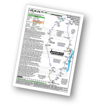
Leek - Mount Road - Holly House - Beely Barn - Morridge - Moor Top - Morridge Side - Egg Well - Roost Hill - Ashenhurst Mill - Lowe Hill - Leek
|
Vital Statistics:
| Length: | 9 miles (14.5 km) |
| Ascent: | 1,178ft (359m) |
| Time: | 4½ hrs |
| Grade: |  |
Route Summary:
Abbey Green - Abbey Wood - Hillswood - North Hillswood Farm - Tittesworth Reservoir - Meerbrook - Lea End - Stockmeadows Farm - Meadows Farm - Turner's Pool - Old Hag Farm - Gun (Staffordshire) - Fould Farm - Abbey Green
|
Vital Statistics:
| Length: | 6.5 miles (10.5 km) |
| Ascent: | 738ft (225m) |
| Time: | 3.25hrs |
| Grade: |  |
Route Summary:
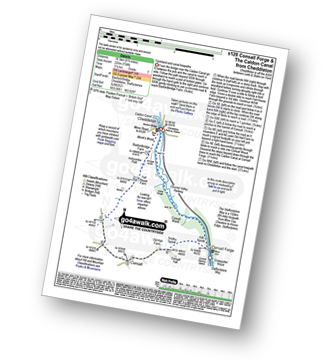
Cheddleton - Basford Bridge - Monk's Wood - Basfordbridge Farm - Felt House Farm - Consall - Consall Forge - River Churnet - Churnet Valley Railway - Caldon Canal - The Staffordshire Way - Consall Wood - Cheddleton
|
Vital Statistics:
| Length: | 8.25 miles (13 km) |
| Ascent: | 1,490ft (454m) |
| Time: | 4½ hrs |
| Grade: | |
Route Summary:
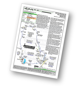
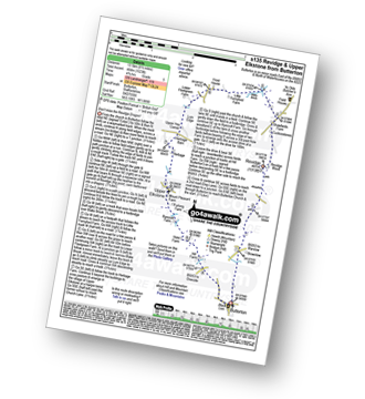
Meerbrook - Lea End - Stockmeadows Farm - Meadows Farm - Buxton Brow Farm - Clough Head - Roach End - Bearstone Rock - The Roaches - Doxey Pool - Rockhall - Hen Cloud - Rockhall - Well Farm - Dains Mill - Upper Hulme - Butty Fold Farm - Tittesworth Reservoir - Meerbrook
|
Vital Statistics:
| Length: | 6 miles (9.5 km) |
| Ascent: | 715ft (218m) |
| Time: | 3 hrs |
| Grade: | |
Route Summary:
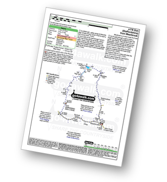
Meerbrook - Lea End - Stockmeadows Farm - Meadows Farm - Turner's Pool - Old Hag Farm - Gun (Staffordshire) - Meerbrook
|
Vital Statistics:
| Length: | 9 miles (14.5 km) |
| Ascent: | 1,795ft (547m) |
| Time: | 5 hrs |
| Grade: |  |

Route Summary:
Upper Hulme - Dains Mill - Blue Hills - Black Brook Nature Reserve - Gib Torr Rocks - Moss Top - Moss End Farm - Black Brook - Roach End - The Roaches - Rockhall - Hen Cloud - Roaches Hall - Upper Hulme
|
Vital Statistics:
| Length: | 7.75 miles (12.5 km) |
| Ascent: | 1,139ft (347m) |
| Time: | 4 hrs |
| Grade: | |
Route Summary:
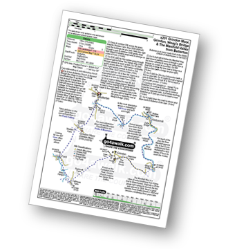
Onecote - Hamps Way - Onecote Grange - The River Hamps - Mixon Mines - Black Brook Farm - Breech Farm - Under The Hill Farm - Upper Elkstone - Ryecroft Farm - Hole Farm - Hill Farm - Butterton - The Twist - Grindon Moor (Grindon Moor) - Home Farm - Onecote
|
Vital Statistics:
| Length: | 3.75 miles (6 km) |
| Ascent: | 775ft (236m) |
| Time: | 2.25hrs |
| Grade: | |

Route Summary:
Five Clouds - Upper Hulme - Rockhall - Doxey Pool - The Roaches - Roach End - Spring Cottage - Five Clouds - Upper Hulme
|
Vital Statistics:
| Length: | 6 miles (9.5 km) |
| Ascent: | 1,234ft (376m) |
| Time: | 3½ hrs |
| Grade: | |

Route Summary:
Five Clouds - Upper Hulme - Rockhall - The Roaches - Roach End - Back Forest - Lud's Church - Rock Chasm - Forest Wood - Roach End - Spring Cottage - Five Clouds - Upper Hulme
|
Vital Statistics:
| Length: | 4.75 miles (7.5 km) |
| Ascent: | 1,182ft (360m) |
| Time: | 3 hrs |
| Grade: | |
Route Summary:
Five Clouds - Pheasants Clough Farm - Roach Grange - Roach End - Bearstone Rock - The Roaches - Doxey Pool - Rockhall - Hen Cloud - Rockhall - Five Clouds
|
Vital Statistics:
| Length: | 4.75 miles (7.5 km) |
| Ascent: | 742ft (226m) |
| Time: | 2½ hrs |
| Grade: | |

Route Summary:
Ipstones - Booth's Hall Farm - Cherryeye Bridge - Caldon Canal - The Staffordshire Way - Podmores Bridge - Booth's Wood - Consall New Lock - Crowgutter Wood - Churnet Valley Railway - Consall Forge - River Churnet - Devil's Staircase - Belmont Hall - Noonsun Common - Ipstones
|
Vital Statistics:
| Length: | 4.5 miles (7 km) |
| Ascent: | 295ft (90m) |
| Time: | 2 hrs |
| Grade: |  |

Route Summary:
Rudyard Reservoir - The Staffordshire Way - Rudyard - Rea Cliffe Wood - Cliffe Park Hall - Rudyard Reservoir
|
Vital Statistics:
| Length: | 10 miles (16 km) |
| Ascent: | 1,404ft (428m) |
| Time: | 5 hrs |
| Grade: | |

Route Summary:
Rudyard Reservoir - The Staffordshire Way - Ryecroft Gate - Rushton Spencer - Heaton Lodge Farm - Weathercock Farm - Gun End House - Gun (Staffordshire) - Fould Farm - Fould Villa - Poolend - Willgate Farm - Rudyard - Black Wood - Rudyard Reservoir
|
Vital Statistics:
| Length: | 8.75 miles (14 km) |
| Ascent: | 1,690ft (515m) |
| Time: | 5 hrs |
| Grade: | |
Route Summary:
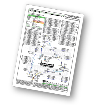
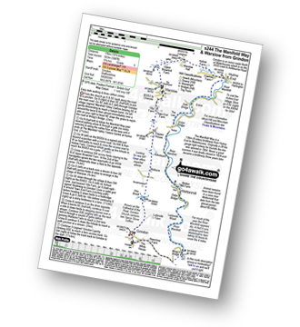
Butterton - Grindon Moor (Grindon Moor) - Ford - Ryebrook Farm - Grindon - Weag's Bridge - The Manifold Way - The River Manifold - Thor's Cave - Ladyside Wood - Dafar Bridge - Wettonmill - Hoo Brook - Butterton
|
Vital Statistics:
| Length: | 9.5 miles (15 km) |
| Ascent: | 1,641ft (500m) |
| Time: | 5 hrs |
| Grade: | |

Route Summary:
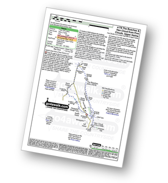
Butterton - Hoo Brook - The Twist - Grindon Moor - Onecote - Waterhouse - Old Mixon Hey Farm - Manor Farm - Hill House - Under The Hill Farm - Upper Elkstone - Ryecroft Farm - Hole Farm - Hill Farm - Butterton
Not familiar with the area around ST13?
See these 30 nearest walks to UK Postcode ST13 on a google map
|
Vital Statistics:
| Length: | 8.5 miles (13.5 km) |
| Ascent: | 1,523ft (464m) |
| Time: | 4.75hrs |
| Grade: | |
Route Summary:
Butterton - Revidge - Cuckoostones - Reaps Moor - Blake Brook - Little Fernyfold Farm - Herbage Barn - Lum Edge - Upper Elkstone - Ryecroft Farm - Hole Farm - Hill Farm - Butterton
|
Vital Statistics:
| Length: | 3.25 miles (5 km) |
| Ascent: | 778ft (237m) |
| Time: | 2 hrs |
| Grade: | |

Route Summary:
Roach End - Back Forest - Forest Wood - Lud's Church - Roach End - The Roaches - Roach End
|
Vital Statistics:
| Length: | 5.5 miles (8.5 km) |
| Ascent: | 896ft (273m) |
| Time: | 3 hrs |
| Grade: | |
Route Summary:
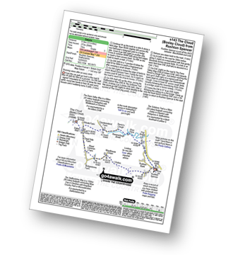
Rushton Spencer - Oulton - Woodhouse Green - Wood Common Farm - Avona - The Staffordshire Way - The Gritstone Trail - The Cloud (Bosley Cloud) - Bosley Cloud - Avona - The Dane Valley Way - Raven's Clough - Ravensclough Brook - Rushton Spencer
|
Vital Statistics:
| Length: | 4 miles (6.5 km) |
| Ascent: | 830ft (253m) |
| Time: | 2.25hrs |
| Grade: | |

Route Summary:
Froghall Wharf - Moseymoor Wood - Whieldon's Wood - Cloughead Wood - Blackbank Brook - Foxt - Newfields Gallery - Shirley Hollow - Oldridge Pinnacle - Harston Wood - Oldridge - Froghall Wharf
|
Vital Statistics:
| Length: | 6 miles (9.5 km) |
| Ascent: | 860ft (262m) |
| Time: | 3 hrs |
| Grade: | |
Route Summary:
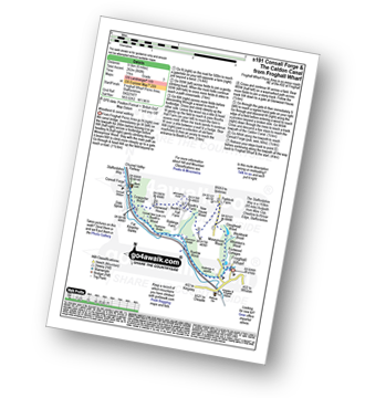
Froghall Wharf - Moseymoor Wood - Ipstones - New House Wood - Booth's Farm - Booth's Hall Farm - Glenwood House - Crowgutter Wood - Caldon Canal - The Staffordshire Way - Consall Forge - Churnet Valley Railway - Consall New Lock - Booth's Wood - Podmores Bridge - Cherryeye Bridge - Ruelow Wood - Froghall - Froghall Wharf
|
Vital Statistics:
| Length: | 10.5 miles (17 km) |
| Ascent: | 1,847ft (563m) |
| Time: | 5.75hrs |
| Grade: | |
Route Summary:
Grindon - Weag's Bridge - The Manifold Way - The River Manifold - Thor's Cave - Dafar Bridge - Wettonmill - Ecton Bridge - Dale Bridge - Ecton - Hulme End - Hollow Farm - Warslow Hall - Upper Brownhill Farm - Warslow - Villa Farm - Clayton House - Wallacre - Hoo Brook - Ladyside Farm - Grindon
|
Vital Statistics:
| Length: | 4.75 miles (7.5 km) |
| Ascent: | 909ft (277m) |
| Time: | 3 hrs |
| Grade: | |

Route Summary:
Grindon - Weag's Bridge - The Manifold Way - Thor's Cave - Wettonmill - Hoo Brook - Grindon
|
Vital Statistics:
| Length: | 9.5 miles (15 km) |
| Ascent: | 1,483ft (452m) |
| Time: | 5 hrs |
| Grade: | |

Route Summary:
Warslow - Villa Farm - Clayton House - Wallacre - Hoo Brook - Butterton - The Twist - Grindon Moor (Grindon Moor) - Onecote - Butterton Moor End Farm - Butterton Moor - Golden Hill - Black Brook Farm - Breech Farm - Underhill Farm - Upper Elkstone - Moorside - Cowhay Head - Warslow
|
Vital Statistics:
| Length: | 7 miles (10.5 km) |
| Ascent: | 787ft (240m) |
| Time: | 3.25hrs |
| Grade: | |

Route Summary:
Wettonmill - Hoo Brook - Butterton - Warslow - Dale Bridge - Ecton - The Manifold Way - The River Manifold - Manifold Valley - Wettonmill
|
Vital Statistics:
| Length: | 5 miles (8 km) |
| Ascent: | 1,306ft (398m) |
| Time: | 3.25hrs |
| Grade: | |

Route Summary:
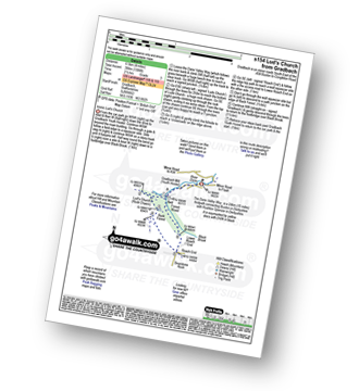
Gradbach - The Dane Valley Way - Gradbach Youth Hostel - The River Dane - Black Brook - Forest Wood - Lud's Church - Back Forest - Roach End - The Roaches - Roach End - Forest Wood - Black Brook - The River Dane - Gradbach Youth Hostel - The Dane Valley Way - Gradbach
|
Vital Statistics:
| Length: | 8.25 miles (13 km) |
| Ascent: | 1,464ft (446m) |
| Time: | 4½ hrs |
| Grade: | |

Route Summary:
Gradbach - The Dane Valley Way - River Dane - Dane View House - Three Shires Head - Panniers Pool - Knotbury Farm - Wolf Edge - Oliver Hill - Flash - Lower House Farm - Flash Brook Farm - Ann Roach Rocks - Gib Torr Rocks - Moss Top - Cloughhead - Gradbach
|
Vital Statistics:
| Length: | 11.5 miles (18.5 km) |
| Ascent: | 1,897ft (578m) |
| Time: | 6.25hrs |
| Grade: | |

Route Summary:
Gradbach - Bradley Howel - Little Hillend - Ann Roach Farm - Adder's Green - Morridge Top - Penthills Farm - Smallshaw Farm - High Ash - Bradshaw Farm - Bottom Hocker - Oakenclough Hall - Oakenclough Brook - Boarsgrove Farm - Middle Hills - Morridge - Royal Cottage - Blackbank Farm - Goldsitch Farm - Black Brook - Cloughhead - Gradbach
|
Vital Statistics:
| Length: | 4 miles (6.5 km) |
| Ascent: | 1,306ft (398m) |
| Time: | 2½ hrs |
| Grade: | |
Route Summary:
Gradbach - The Dane Valley Way - Gradbach Youth Hostel - The River Dane - Black Brook - Forest Wood - Lud's Church - Back Forest - Roach End - Forest Wood - Black Brook - The River Dane - Gradbach Youth Hostel - The Dane Valley Way - Gradbach
|
Vital Statistics:
| Length: | 11.5 miles (18.5 km) |
| Ascent: | 2,274ft (693m) |
| Time: | 6½ hrs |
| Grade: | |

Route Summary:
Gradbach - The Dane Valley Way - Gradbach Youth Hostel - Black Brook - Forest Wood - Roach End - The Roaches - Doxey Pool - Rockhall - Hen Cloud - Well Farm - Dains Mill - Upper Hulme - Butty Fold Farm - Staffordshire Moorlands Walk - Tittesworth Reservoir - Meerbrook - Stockmeadows Farm - Meadows Farm - Buxton Brow - Clough Head - Back Forest - Lud's Church - Rock Chasm - Black Brook - Gradbach Youth Hostel - The Dane Valley Way - Gradbach
|
Vital Statistics:
| Length: | 15 miles (24 km) |
| Ascent: | 2,028ft (618m) |
| Time: | 8 hrs |
| Grade: |  |

Route Summary:
Weag's Bridge - River Manifold - Beeston Tor Farm - River Hamps - Soles Coppice - Old Soles Wood - Hell Hole - Lee House - Farwell Farm - Calton - Carlton Green - Rushley Wood - Musden Wood - Rushley - Ilam Country Park - Ilam - River Dove - Dovedale Castle - Dove Dale - The River Dove - Stepping Stones - Lover's Leap - Tissington Spires - Shaplow Dale,Natural Arch - Raynard's Cave - Upper Taylor's Wood - Dove Holes - Viator's Bridge - Milldale - Alstonefield - Wetton - Thor's Cave - Weag's Bridge
Not familiar with the area around ST13?
See these 30 nearest walks to UK Postcode ST13 on a google map


