UK Postcode SG5 - The 30 nearest easy-to-follow, circular walk route maps to you
The thirty nearest easy-to-follow, circular walk route maps to you in UK Postcode SG5 in Walk Grade Order
The UK cities, towns and villages in Bedfordshire, England that have SG5 in their UK Postcode include:
• Apsley End • Astwick • Charlton • Great Offley • Hexton • Higham Gobion • Hitchin • Holwell • Ickleford • Pirton • Shillington • Stotfold • Upton End •
Not familiar with the area around SG5?
See these 30 nearest walks to UK Postcode SG5 on a google map
   |
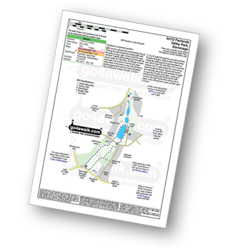
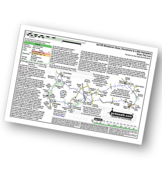
Vital Statistics:
| Length: | 2.25 miles (3.5 km) |
| Ascent: | 72ft (22m) |
| Time: | 1 hrs |
| Grade: |  |
|
Vital Statistics:
| Length: | 4.75 miles (7.5 km) |
| Ascent: | 249ft (76m) |
| Time: | 2 hrs |
| Grade: |  |

|
Vital Statistics:
| Length: | 7.5 miles (12 km) |
| Ascent: | 315ft (96m) |
| Time: | 3 hrs |
| Grade: | |
|
Vital Statistics:
| Length: | 6.25 miles (70 km) |
| Ascent: | 240ft (73m) |
| Time: | 2½ hrs |
| Grade: | |
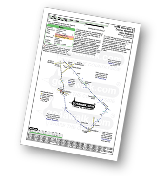
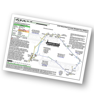
Route Summary:
Ardeley - Wood End - Roman Road - Hare Street - Roman Road - Hare Street - Cromer Windmill - Ardeley
|
Vital Statistics:
| Length: | 6.5 miles (10.5 km) |
| Ascent: | 637ft (194m) |
| Time: | 3 hrs |
| Grade: |  |
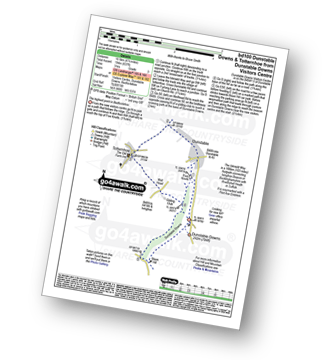
Route Summary:
Dunstable Downs Visitors Centre - The Icknield Way - Five Knolls - Drovers Way - Totternhoe - Well Head - Bison Hill - Dunstable Downs Visitors Centre
|
Vital Statistics:
| Length: | 6.5 miles (10 km) |
| Ascent: | 722ft (220m) |
| Time: | 3 hrs |
| Grade: | |

Route Summary:
Dagnall - Chlitern Farm - Former Radio Station - Gallows Hill - Ivinghoe Beacon - The Ridgeway - Ivinghoe Hills - Steps Hill - Down Farm - Clipperdown Cottage - Clipper Down - Ward's Hurst Farm - Hog Hall - Hog Hall Lane - Dagnall
|
Vital Statistics:
| Length: | 4.5 miles (7 km) |
| Ascent: | 295ft (90m) |
| Time: | 2 hrs |
| Grade: | |

Route Summary:
Little Gransden - Waresley - Waresley Wood - Waresley Dean Brook - Gransden Wood - Squirrels' Grove - Gransden Park - Great Gransden - Home Dole Brook - Little Gransden
|
Vital Statistics:
| Length: | 6.5 miles (10 km) |
| Ascent: | 328ft (100m) |
| Time: | 2½ hrs |
| Grade: | |

Route Summary:
Turvey - Turvey Abbey - Priory Farm - Grotto Plantation - Hill Spinney - Ramacre Wood - Gorewell - The Milton Keynes Boundary Walk - Gullet Wood - Keepers (Church's) Cottage - Woodside - Turvey
|
Vital Statistics:
| Length: | 8.25 miles (13 km) |
| Ascent: | 919ft (280m) |
| Time: | 4 hrs |
| Grade: |  |
Route Summary:
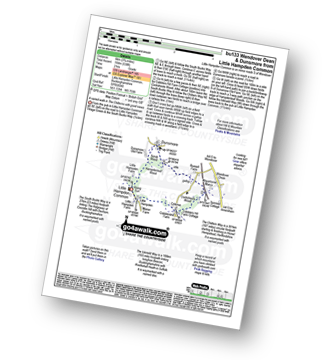
The Lee - Kiln Cottage - Lee Gate - The Chiltern Way - Durham Farm - Wendoverdean Farm - Wendover Dean - Mayortorne Manor - Russell Farm - Dunsmore - Scrub Wood - Hampdenleaf Wood - The Icknield Way - Little Hampden Common - Little Hampden - The South Bucks Way - Cobblershill Farm - The Chiltern Way - Cockshoots Wood - Mayortorne Manor - Spinney Cottage - The Lee
|
Vital Statistics:
| Length: | 4.5 miles (7 km) |
| Ascent: | 345ft (105m) |
| Time: | 2 hrs |
| Grade: | |
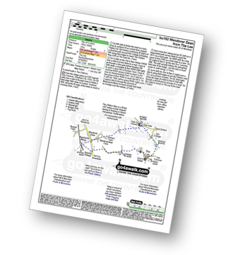
Route Summary:
The Lee - Kiln Cottage - Lee Gate - The Chiltern Way - Durham Farm - Wendoverdean Farm - Wendover Dean - Mayortorne Manor - Spinney Cottage - The Lee
|
Vital Statistics:
| Length: | 9 miles (14.5 km) |
| Ascent: | 256ft (78m) |
| Time: | 3.75hrs |
| Grade: | |
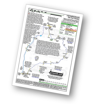
Route Summary:
Takeley - Hope End Green - Cow Common - Hellman's Cross - Taverners Green - Hatfield Broad Oak - Three Forests Way - Pincy Brook - Bush End - Harcamlow Way - The Flitch Way - Takeley
|
Vital Statistics:
| Length: | 5 miles (8 km) |
| Ascent: | 230ft (70m) |
| Time: | 2 hrs |
| Grade: | |
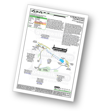
Route Summary:
Little Missenden - The South Bucks Way - Lower Park - Shardeloes Lake - Amersham Cricket Ground - Lower Park House - Wheatley Wood - Mop End - Mop End Farm - Taby's Lane - Breaches Wood - Little Missenden
|
Vital Statistics:
| Length: | 5.5 miles (9 km) |
| Ascent: | 853ft (260m) |
| Time: | 3 hrs |
| Grade: | |

Route Summary:
Butler's Cross - Monument Hill (Coombe Hill) - The Ridgeway - Linton's Wood - Goodmerhill Wood - Chisley Wood - The Icknield Way - Chequers - Pond Wood - Pulpit Wood - The North Bucks Way - The Midshires Way - Chequers Knap - Whorley Wood - Ellesborough Warren - Boxtree Wood - Beacon Hill (Ellesborough) - Ellesborough - The Aylesbury Ring - Springs Farm - Butler's Cross
|
Vital Statistics:
| Length: | 3.75 miles (6 km) |
| Ascent: | 538ft (164m) |
| Time: | 2 hrs |
| Grade: | |
Route Summary:
Little Hampden Common - Little Hampden - The South Bucks Way - Cobblershill Farm - The Chiltern Way - Cockshoots Wood - Mayortorne Manor - Russell Farm - Dunsmore - Scrub Wood - Hampdenleaf Wood - The Icknield Way - Little Hampden Common
|
Vital Statistics:
| Length: | 6.5 miles (10 km) |
| Ascent: | 82ft (25m) |
| Time: | 2½ hrs |
| Grade: | |

Route Summary:
Fulbourn - Harcamlow Way - Cole's Bridge - New Cut Drain - Hawk Mill Farm - Little Wilbraham - Great Wilbraham - Fleam Dyke - Fulbourn
Not familiar with the area around SG5?
See these 30 nearest walks to UK Postcode SG5 on a google map
|
Vital Statistics:
| Length: | 4.5 miles (7 km) |
| Ascent: | 693ft (211m) |
| Time: | 2½ hrs |
| Grade: | |

Route Summary:
Great Kimble - The North Bucks Way - Askett - Monks Risborough - Whiteleaf - The Icknield Way - The Ridgeway - Whiteleaf Cross - Cadsden - Grangelands And Pulpit Hill Nature Reserve - Chequer's Knap - The North Bucks Way - Great Kimble
|
Vital Statistics:
| Length: | 6.5 miles (10.5 km) |
| Ascent: | 230ft (70m) |
| Time: | 2½ hrs |
| Grade: | |
Route Summary:
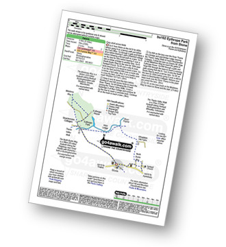
Stone - Hartwell Church - Upper Hartwell - Whaddon Hill Farm - The North Bucks Way - River Thame - Thame Valley Walk - The Midshires Way - Weir Lodge - Bridge Lodge - Eythrope Park - Beachendon Cottages - Eythrope House - Aylesbury Ring - Stone
|
Vital Statistics:
| Length: | 5.5 miles (9 km) |
| Ascent: | 722ft (220m) |
| Time: | 2.75hrs |
| Grade: | |
Route Summary:
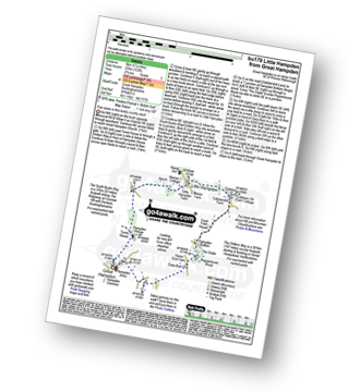
Great Hampden - The Chiltern Way - Hampden House - Little Hampden - The South Bucks Way - Cobbleshill Farm - Hampden Bottom - Pepperboxes Wood - Honor End Farm - Great Hampden
|
Vital Statistics:
| Length: | 9 miles (14.5 km) |
| Ascent: | 328ft (100m) |
| Time: | 3½ hrs |
| Grade: | |
Route Summary:
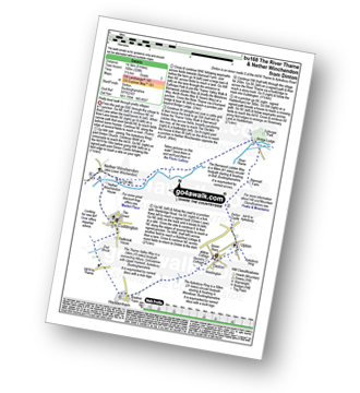
Dinton - Upton - The Aylsebury Ring - Dinton Castle - Starveall Farm - Eythrope Park - The Midshires Way - The North Bucks Way - The Swans Way - Bridge Lodge - The River Thame - The Bernwood Jubilee Way - The Thame Valley Way - Nether Winchendon - Lower Winchendon - Cuddington - Haddenham - Dad Brook - Townsend - Haddenham - Westington - Dinton
|
Vital Statistics:
| Length: | 6 miles (9.5 km) |
| Ascent: | 528ft (161m) |
| Time: | 2.75hrs |
| Grade: | |
Route Summary:
Bledlow - The Midshires Way - The Warren - The Ridgeway - Thickthorn Wood - Lodge Hill - Longwood Farm - The Old Rectory - Saunderton - Horsenden - Bledlow
|
Vital Statistics:
| Length: | 8.5 miles (13.5 km) |
| Ascent: | 246ft (75m) |
| Time: | 3½ hrs |
| Grade: | |
|
Vital Statistics:
| Length: | 4.75 miles (7.5 km) |
| Ascent: | 476ft (145m) |
| Time: | 2.25hrs |
| Grade: | |
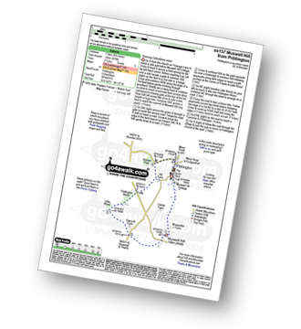
Route Summary:
Piddington - Muswell Hill - Oakcroft Farm - Little Wood - Piddington Wood - Widnell Park - Piddington
|
Vital Statistics:
| Length: | 7 miles (11 km) |
| Ascent: | 650ft (198m) |
| Time: | 3.25hrs |
| Grade: | |
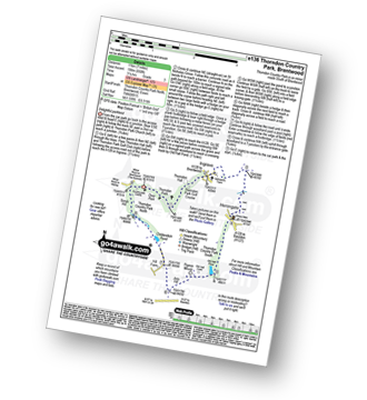
Route Summary:
Thorndon Country Park North - Thorndon Park - Thorndon Hall - Ingrave - Herongate - Thorndon Country Park South - Old Hall Pond - Pigeon Mount - Jury Hill - Childerditch Pond - Scrub Hill - Countryside Centre - Thorndon Country Park North
|
Vital Statistics:
| Length: | 7.25 miles (11.5 km) |
| Ascent: | 381ft (116m) |
| Time: | 3 hrs |
| Grade: | |

Route Summary:
Richmond Park - Pembroke Lodge - Hamcross Plantation - Ham Bottom - Park Gate - Kingston Gate - Robin Hood Gate - Beverley Brook - Roehampton Gate - Adam's Pond - Sheen Gate - The Bog - Richmond Gate - Richmond Park (Richmond Park) - Pembroke Lodge - Richmond Park
|
Vital Statistics:
| Length: | 7.75 miles (12.5 km) |
| Ascent: | 295ft (90m) |
| Time: | 3.25hrs |
| Grade: | |
|
Vital Statistics:
| Length: | 6.75 miles (10 km) |
| Ascent: | 256ft (78m) |
| Time: | 2.75hrs |
| Grade: | |
|
Vital Statistics:
| Length: | 5 miles (8 km) |
| Ascent: | 345ft (105m) |
| Time: | 2.25hrs |
| Grade: | |
Route Summary:
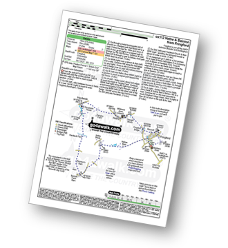
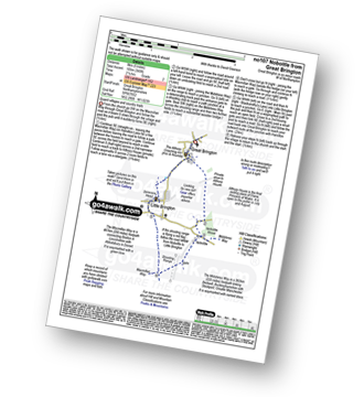
Great Brington - Nobottle Wood - The Midshires Way - Nobottle - The Macmillan Way - Little Brington - Great Brington
|
Vital Statistics:
| Length: | 5.25 miles (8.5 km) |
| Ascent: | 177ft (54m) |
| Time: | 2.25hrs |
| Grade: | |
Route Summary:
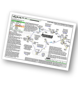
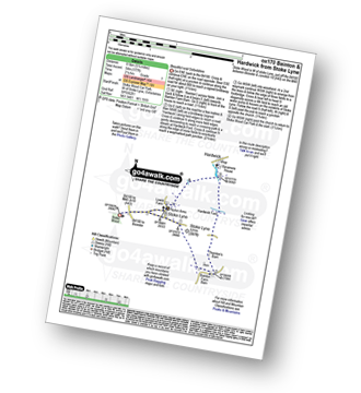
Stoke Wood - Stoke Lyne - Bainton - Hardwick Ford - Hardwick - Stoke Bushes - Stoke Lyne - Stoke Wood
|
Vital Statistics:
| Length: | 4.25 miles (6.5 km) |
| Ascent: | 131ft (40m) |
| Time: | 1.75hrs |
| Grade: | |
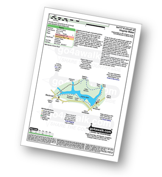
Route Summary:
Virginia Water - Wick Pond - Totem Pole - Oxshed Clump - Valley Gardens - Heather Gardens - Johnson's Pond - Blacknest - Frostform Plantation - Leptis Magna Roman Ruins - Cascade Bridge - Virginia Water
|
Vital Statistics:
| Length: | 5.5 miles (9 km) |
| Ascent: | 499ft (152m) |
| Time: | 2½ hrs |
| Grade: | |

Not familiar with the area around SG5?
See these 30 nearest walks to UK Postcode SG5 on a google map


