   |
Vital Statistics:
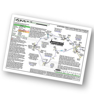
| Length: | 7¾mls (12.5km) |
| Ascent: | 295ft (90m) |
| Time: | 3¼hrs |
| Grade: |  |
Route outline for walk ox148:
Fringford - Hethe - Hardwick - Stoke Lyne - Bainton - Hethe Brede - Fringford
Points of Interest/Notes on this walk:
The monument in the field north of Bainton was erected in 1812 by Sir Thomas Mostyn Bart MP, master of the Bicester Foxhounds 1800-1830, in memory of his favourite dog 'Lady'.
You can find this walk and other nearby walks on these unique free-to-access Interactive Walk Planning Maps:
1:25,000 scale OS Explorer Map (orange/yellow covers):
An Interactive Walk Planning Map for OS Explorer 191 Banbury, Bicester & Chipping Norton is not currently available
1:50,000 scale OS Landranger Map (pink/magenta covers):
Send us your photographs and pictures from your walks and hikes
We would love to see your photographs and pictures from walk ox148 Fringford from Stoke Lyne. Send them in to us as email attachments (configured for any computer) along with your name and where the picture was taken to:
and we shall do our best to publish them.
(Guide Resolution = 300dpi. At least = 660 pixels (wide) x 440 pixels (high).)

You can also submit photos from walk ox148 Fringford from Stoke Lyne via our Facebook Page.
NB. Please indicate where each photo was taken.


