Walk c175 Slight Side and Sca Fell from Wha House Farm, Eskdale
This 10 mile, Grade 7 (Hard), easy-to-follow, hand-crafted walk, complete with GPS Waypoints, starts at Eskdale & will take about 7 hrs to complete.
   |
Vital Statistics:
| Length: | 10mls (16km) |
| Ascent: | 3,401ft (1,037m) |
| Time: | 7hrs |
| Grade: |  |

Route outline for walk c175:
Eskdale - Wha House Farm - Hare Crag - Goat Crag - Dawsonground Crags - Cat Crag - Quagrigg Moss - Slight Side - Sca Fell - Symonds Knott - Hard Rigg - Burnmoor Tarn - Eel Tarn - Christcliff - Wha House Farm - Eskdale
Peaks, Summits and Tops reached on this walk:
 1 English Mountain |
 2 Wainwrights |
 2 English Nuttalls |
 0 English Deweys |
 0 Wainwright Outlying Fells |
 0 Marilyns |
 0 Bridgets |
Peak Bagging Statistics for this walk:
The highest point of this walk is Sca Fell at 964m (3163ft). Sca Fell is classified as an English Mountain (Hewitt) (2nd highest in England, 10th highest in England & Wales) and a Wainwright (No. 2).
Sca Fell is also known as an English Nuttall (2nd highest in England, 11th highest in England & Wales).
Completing this walk will also take you to the top of Symonds Knott at 959m (3147ft). Symonds Knott is also known as an English Nuttall (3rd highest in England, 13th highest in England & Wales).
You will also reach the summit of Slight Side at 762m (2501ft). Slight Side is classified as an Wainwright (No. 58).
You can find this walk and other nearby walks on these unique Interactive Walk Planning Maps:
(worth a look if you're new to go4awalk.com & have never seen one of these before.)
1:25,000 scale OS Explorer Map (orange/yellow covers):
1:50,000 scale OS Landranger Maps (pink/magenta covers):
Some Photos and Pictures from Walk c175 Slight Side and Sca Fell from Wha House Farm, Eskdale
In no particular order . . .

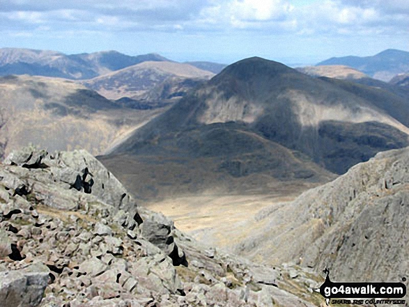
Great Gable (back), Lingmell, the shoulder of Scafell Pike and Mickeldore from Symonds Knott


Little Stand (foreground), Pike of Blisco (Pike o' Blisco) (left), Wetherlam and The Old Man of Coniston (right) from Slight Side


. . . load all 48 walk photos from Walk c175 Slight Side and Sca Fell from Wha House Farm, Eskdale
Send us your photographs and pictures from your walks and hikes
We would love to see your photographs and pictures from walk c175 Slight Side and Sca Fell from Wha House Farm, Eskdale. Send them in to us as email attachments (configured for any computer) along with your name and where the picture was taken to:
and we shall do our best to publish them.
(Guide Resolution = 300dpi. At least = 660 pixels (wide) x 440 pixels (high).)

You can also submit photos from walk c175 Slight Side and Sca Fell from Wha House Farm, Eskdale via our Facebook Page.
NB. Please indicate where each photo was taken.

To contribute to go4awalk.com or to contact us about anything at all - see Talk To Us.
For help see Help.
go4awalk.com and go4awalk.co.uk are registered trademarks of TMDH Limited.
Copyright © 2000-2026 TMDH Limited. All rights reserved.
Copyright Terms & Conditions Privacy Statement
A - Z Walks Home Log On/Accounts Photo Gallery Walk Ideas and Collections Fell Facts Hill Skills Walking Questions and Answers Your Stories News Competitions Product Reviews/Gear Tests Walking Gear Guides Peaks and Mountains Peak Bagging Find New Walking Friends Camping GPS Waypoints for Walking Contents Walk Search Talk To Us go4awalk.com Help Free Example Walks Newsletter


