UK Postcode LA8 - The 30 nearest easy-to-follow, circular walk route maps to you
The thirty nearest easy-to-follow, circular walk route maps to you in UK Postcode LA8 in Walk Grade Order
The UK cities, towns and villages in Cumbria, England that have LA8 in their UK Postcode include:
• Beck Foot • Brigsteer • Cotes • Crook • Crosthwaite • Endmoor • Garnett Bridge • Gatebeck • Grayrigg • Grigghall • Howe • Ings • Kentmere • Levens • Low • Lowgill • Middleshaw • Millholme • Mitchelland • New Hutton • Old Hutton • Row • Sadgill • Sedgwick • Stainton • Staveley • Underbarrow • Watchgate • Winster •
Not familiar with the area around LA8?
See these 30 nearest walks to UK Postcode LA8 on a google map
   |
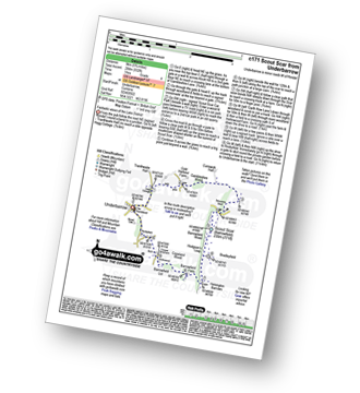
Vital Statistics:
| Length: | 7.25 miles (11.5 km) |
| Ascent: | 1,053ft (321m) |
| Time: | 3.75hrs |
| Grade: |  |

Route Summary:
Kendal - Kendal Fell - Kettlewell Crag - Cunswick Fell - Cunswick Scar - Scout Scar (Barrowfield) - Helsington Barrows - Bradleyfield - Brigsteer Road - Larch How - Kendal
|
Vital Statistics:
| Length: | 5.75 miles (9 km) |
| Ascent: | 932ft (284m) |
| Time: | 3 hrs |
| Grade: | |
Route Summary:
Underbarrow - Hagg Cottage - Gambleshire Lane - Gambleshire Lane - Cunswick Fell - Scout Scar (Barrowfield) - Hodgeson's Leap - Bradleyfield - Helsington Barrows - Barrowfield Farm - Barrowfield Lot - Copeland Wood - Hollinwood - Cooper Tenement - Rockyfield - Underbarrow
|
Vital Statistics:
| Length: | 10 miles (16 km) |
| Ascent: | 1,496ft (456m) |
| Time: | 5.25hrs |
| Grade: |  |

Route Summary:
Underbarrow - Hagg Cottage - Gambleshire Lane - Gambleshire Lane - Cunswick Fell - Cunswick Scar - Scout Scar (Barrowfield) - Hodgeson's Leap - Bradleyfield - Helsington Barrows - Windy Howe - Helsington Church - Honeybee Wood - Barrowfield Farm - Barrowfield Lot - Copeland Wood - Hollinwood - Cooper Tenement - Rockyfield - Underbarrow
|
Vital Statistics:
| Length: | 5.5 miles (8.5 km) |
| Ascent: | 974ft (297m) |
| Time: | 3 hrs |
| Grade: | |

Route Summary:
Staveley - Barley Bridge - Craggy Plantation - Spy Crag - Littlewood Farm - Birk Field Farm - Potter Tarn - Ghyll Pool - Hundhowe - Hagg Foot - The River Kent - The Dales Way - Beckmickle Ing - Staveley
|
Vital Statistics:
| Length: | 5.25 miles (8.5 km) |
| Ascent: | 899ft (274m) |
| Time: | 3 hrs |
| Grade: |  |
|
Vital Statistics:
| Length: | 6 miles (9.5 km) |
| Ascent: | 531ft (246m) |
| Time: | 2½ hrs |
| Grade: | |

Route Summary:
Ings - High Fairbank - The Dales Way - Crag House Farm - Outrun Nook - Hag End Farm - School Knott - Schoolknott Plantation - Whasdike Farm - Ings
|
Vital Statistics:
| Length: | 7 miles (11 km) |
| Ascent: | 1,218ft (371m) |
| Time: | 3.75hrs |
| Grade: | |

Route Summary:
Winster Church - Winster House - Birkett Houses Allotments - Ghyll Head Reservoir - Great Ludderburn Moss - Little Ludderburn Moss - Ludderburn Hill - The Oaks - Intake Wood - High Hartbarrow - Lound Cottage - Strawberry Bank - Hollins Farm - Great Hartbarrow - Wood Farm - River Winster - Bryan House Farm - Winster Church
|
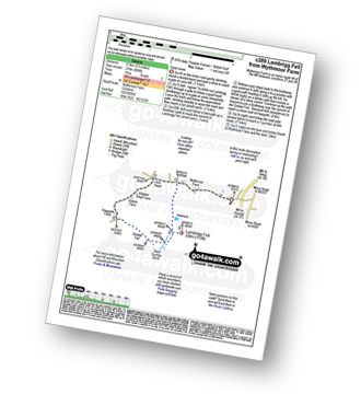
Vital Statistics:
| Length: | 4.75 miles (7.5 km) |
| Ascent: | 945ft (288m) |
| Time: | 2.75hrs |
| Grade: | |

Route Summary:
Witherslack Hall School - Black Yews Scar - Flodder Allotment - Lord's Seat (Whitbarrow Scar) - Farrar's Allotment - Whitbarrow Scar - Buckhouse Wood - Beck Head (Witherslack) - Witherslack Hall School
|
Vital Statistics:
| Length: | 6.75 miles (11 km) |
| Ascent: | 1,243ft (379m) |
| Time: | 3.75hrs |
| Grade: | |
Route Summary:
Mill Side - Buckhouse Wood - Farrar's Allotment - Pether Pots. Whitbarrow National Nature Reserve - Lord's Seat (Whitbarrow Scar) - Flodder Allotment - Bell Rake - High Park Wood - Black Yew Scars - Witherslack Hall School - Chapel Head Scar - High Crag Wood - Low Crag Wood - Beck Head - Mill Side
|
Vital Statistics:
| Length: | 7.25 miles (11.5 km) |
| Ascent: | 1,247ft (380m) |
| Time: | 3.75hrs |
| Grade: | |

Route Summary:
Windermere - Orrest Head - Moorhowe - Dubbs Road - Garburn Road - Longmire Road - Far Orrest Farm - Orrest Head - Windermere
|
Vital Statistics:
| Length: | 7.5 miles (12 km) |
| Ascent: | 787ft (240m) |
| Time: | 3½ hrs |
| Grade: | |

Route Summary:
Windermere - Ellery Woods - Orrest Head - Near Orrest Farm - Mislet Farm - Heaning Farm - Blackmoss Farm - School Knott Plantation - School Knott - The Dales Way - High Cleabarrow Farm - Matson Ground - Heaththwaite Manor - Windermere
|
Vital Statistics:
| Length: | 8.25 miles (13 km) |
| Ascent: | 1,572ft (479m) |
| Time: | 4½ hrs |
| Grade: | |

Route Summary:
Huck's Bridge - Ashstead Fell - Mabbin Crag - Castle Fell - Whinfell Beacon - Low Borrowdale - Borrow Beck - High Borrowdale - Borrowdale - Huck's Bridge
|
Vital Statistics:
| Length: | 4.5 miles (7 km) |
| Ascent: | 1,214ft (370m) |
| Time: | 3 hrs |
| Grade: | |

Route Summary:
Hause Bridge Parking Area - Grayrigg Pike - Grayrigg Forest - Repeater Station - Borrowdale Wood - Hause Bridge Parking Area
|
Vital Statistics:
| Length: | 10.5 miles (17 km) |
| Ascent: | 3,417ft (1,041m) |
| Time: | 7.25hrs |
| Grade: |  |

Route Summary:
Stockdale - Sadgill Bridge - Stockdale Beck - Great Howe - Grey Crag (Sleddale) - Tarn Crag (Sleddale) - Sleddale Fell - Selside Brow - Branstree (Artlecrag Pike) - Gatescarth Pass - Adam Seat - Harter Fell (Mardale) - Kentmere Pike - Goat Scar - Shipman Knotts - Wray Crag - Stockdale
|
Vital Statistics:
| Length: | 4.75 miles (7.5 km) |
| Ascent: | 1,890ft (576m) |
| Time: | 3½ hrs |
| Grade: | |
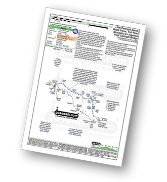
Route Summary:
Carlingill Bridge - Carlingill Beck - Carlin Gill - Screes of Black Force - Carlingill Spout - Little Ulgill Beck - Black Force - Ulgill Rigg - Fell Head (Howgills) - Linghaw - Knowles - Back Balk - Gibbet Hill - Carlingill Bridge - The Howgill Fells.
Not familiar with the area around LA8?
See these 30 nearest walks to UK Postcode LA8 on a google map
|
Vital Statistics:
| Length: | 11 miles (17.5 km) |
| Ascent: | 4,430ft (1,350m) |
| Time: | 8½ hrs |
| Grade: |  |

Route Summary:
Carlingill Bridge - The Howgills - Carlingill Beck - Carlin Gill - Screes of Black Force - Carlingill Spout - Blakethwaite Bottom - Docker Knott - Great Blea Gill - Simon's Seat (Howgills) - Langdale Beck (Howgills) - Hazelgill Knott - Bowderdale Beck - Bowderdale Head - Cautley Spout - Cautley Crag - Great Dummacks - Little Dummacks - Calders - Bram Rigg Top - The Calf - White Fell Head - Bush Howe - Windscarth Wyke - Breaks Head - Fell Head (Howgills) - Fell Head Scar - Linghaw - Knowles - Back Balk - Gibbet Hill - Carlingill Bridge - The Howgill Fells.
|
Vital Statistics:
| Length: | 11.5 miles (18.5 km) |
| Ascent: | 3,378ft (1,030m) |
| Time: | 7½ hrs |
| Grade: | |

Route Summary:
Kentmere - Garburn Pass - Yoke - Ill Bell - Froswick - Thornthwaite Crag - Mardale Ill Bell - Nan Bield Pass - Harter Fell (Mardale) - Kentmere Pike - Brookstones - Kentmere
|
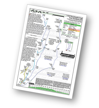
Vital Statistics:
| Length: | 8.5 miles (13.5 km) |
| Ascent: | 1,644ft (501m) |
| Time: | 4.75hrs |
| Grade: | |

Route Summary:
Far Sawrey - Mitchell Knotts - Low Pate Crag - Claife Heights (High Blind How) - The Heald - High Moss - Belle Grange Beck - Long Height - Latterbarrow - High Wray - Red Nap Car Park - Lake Windermere - Belle Grange Bay - Bark Barn Ferry - Slape Scar - Strawberry Gardens - Far Sawrey
|
Vital Statistics:
| Length: | 7 miles (11 km) |
| Ascent: | 945ft (288m) |
| Time: | 3½ hrs |
| Grade: | |
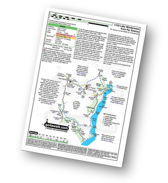
Route Summary:
Far Sawrey - Mitchell Knotts - Fellborough - Lake Windermere Shore - Rawlinson Nab - Low Cunsey Farm - Cunsey Wood - The Forge - Great Ore Gate - Cunsey Beck - Eel House Bridge - Dub How Farm - Near Sawrey - Hill Top (former Home of Beatrix Potter) - Wilfin Beck - Far Sawrey
|
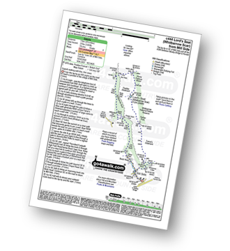
Vital Statistics:
| Length: | 3.75 miles (6 km) |
| Ascent: | 627ft (191m) |
| Time: | 2 hrs |
| Grade: |  |
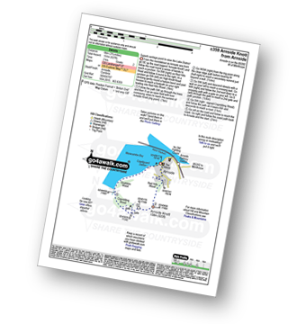
Route Summary:
Arnside (Morecambe Bay) - Red Hills Wood - Arnside Knott - Copridding Wood - Grubbins Wood - Morecambe Bay - The Cumbria Coastal Way - Arnside (Morecambe Bay)
|
Vital Statistics:
| Length: | 13.5 miles (21.5 km) |
| Ascent: | 2,317ft (706m) |
| Time: | 7.25hrs |
| Grade: | |

Route Summary:
Hodge Bridge - Barbon - Thorn Moor - Eskholme Pike - Castle Knott - Calf Top - Barkin Top - Longbank Peat Moss - Long Bank - Fellside Farm - River Lune - Low Waterside Farm - Middleton Hall Bridge - Stockdale Beck - Applegarth - Borwens - Eller Beck - Barbon - Hodge Bridge
|
Vital Statistics:
| Length: | 9.5 miles (15 km) |
| Ascent: | 3,114ft (949m) |
| Time: | 6½ hrs |
| Grade: | |

Route Summary:
Sedbergh - Settlebeck Gill - Winder Hill - Arant Haw - Calders - Bram Rigg Top - The Calf - White Fell Head - Long Rigg Beck - Ivy Crag - Eller Mire - Crosdale Beck - Nursery Wood - Lockbank Farm - Sedbergh
|
Vital Statistics:
| Length: | 12.25 miles (19.5 km) |
| Ascent: | 4,194ft (1,278m) |
| Time: | 8.75hrs |
| Grade: | |
Route Summary:
Troutbeck Bridge - Garburn Pass - Yoke - Ill Bell - Froswick - Thornthwaite Crag - Stony Cove Pike (Caudale Moor) - Doup Crag - Trout Beck - Troutbeck Tongue - Hagg Gill - Lowther Brow - Long Green Head - Limefitt Campsite - Troutbeck - Troutbeck Bridge
|
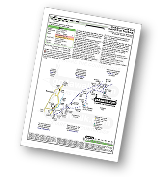
Vital Statistics:
| Length: | 8.25 miles (13 km) |
| Ascent: | 1,421ft (433m) |
| Time: | 4½ hrs |
| Grade: | |

Route Summary:
Troutbeck Bridge - Troutbeck - Limefitt Holiday Park - Long Green Head - Ing Bridge - Troutbeck Park - Park Fell Head - Trout Beck - Troutbeck Tongue - Hagg Gill - Lowther Brow - Long Green Head - Limefitt Holiday Park - Troutbeck - Troutbeck Bridge
|
Vital Statistics:
| Length: | 5.5 miles (8.5 km) |
| Ascent: | 1,582ft (482m) |
| Time: | 3.75hrs |
| Grade: | |
Route Summary:
Troutbeck Bridge - Garburn Road - Backstone Barrow - Sour Howes - Sallows - Garburn Pass - Troutbeck - Troutbeck Bridge
|
Vital Statistics:
| Length: | 11 miles (17.5 km) |
| Ascent: | 3,410ft (1,039m) |
| Time: | 7½ hrs |
| Grade: | |

Route Summary:
Troutbeck Bridge - Garburn Road - Backstone Barrow - Sour Howes - Sallows - Garburn Pass - Yoke - Ill Bell - Froswick - Wanfer Crag - Hagg Gill - Trout Beck - Troutbeck Tongue - Lowther Brow - Long Green Head - Limefitt Campsite - Troutbeck - Troutbeck Bridge
|
Vital Statistics:
| Length: | 9.5 miles (15 km) |
| Ascent: | 2,050ft (625m) |
| Time: | 5½ hrs |
| Grade: |  |

Route Summary:
Demings Moss - Shap - Whatshaw Common - Little Yarlside - Great Yarlside - Harrop Pike - Grey Crag (Sleddale) - Lord's Seat (Crookdale) - Robin Hood (Crookdale) - High House Bank - Demings Moss - Shap.
|
Vital Statistics:
| Length: | 7.25 miles (11.5 km) |
| Ascent: | 896ft (273m) |
| Time: | 3½ hrs |
| Grade: | |

Route Summary:
Hawkshead - Colthouse - Long Height - Holland Band Plantation - Wise Een Tarn - Scale Tarn - Moss Eccles Tarn - Stones Lane - Near Sawrey - Hill Top (former Home of Beatrix Potter) - Ees Bridge - Esthwaite Tarn - Howe Farm - Roger Ground - Hawkshead
|
Vital Statistics:
| Length: | 6.5 miles (10.5 km) |
| Ascent: | 1,076ft (328m) |
| Time: | 3.75hrs |
| Grade: | |
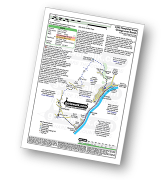
Route Summary:
Grange-over-Sands - Eggerslack Wood - Hampsfell - Fell End - High Fell Gate Farm - Allithwaite - The Cumbria Coastal Way - Kents Bank - Morecambe Bay - Grange-over-Sands
|
Vital Statistics:
| Length: | 10.25 miles (16.5 km) |
| Ascent: | 1,375ft (419m) |
| Time: | 5.25hrs |
| Grade: | |
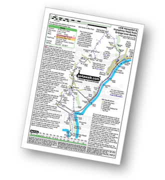
Route Summary:
Grange-over-Sands - Eggerslack Wood - Hampsfell - Fell End - High Fell Gate Farm - Allithwaite - Wraysholme Tower - The Cumbria Coastal Way - Humphrey Head - Humphrey Head Wood - Wyke Farm - Kirkhead End - Allithwaite - Kents Bank - Morecambe Bay - Grange-over-Sands
Not familiar with the area around LA8?
See these 30 nearest walks to UK Postcode LA8 on a google map


