UK Postcode L40 - The 30 nearest easy-to-follow, circular walk route maps to you
The thirty nearest easy-to-follow, circular walk route maps to you in UK Postcode L40 in Walk Grade Order
The UK cities, towns and villages in Lancashire, England that have L40 in their UK Postcode include:
• Bescar • Burscough • Burscough Bridge • Holmeswood • Mawdesley • New Lane • Pinfold • Rufford • Scaris-brick • Scarth Hill • Tarlscough • Westhead •
Not familiar with the area around L40?
See these 30 nearest walks to UK Postcode L40 on a google map
   |
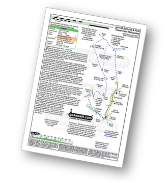
Vital Statistics:
| Length: | 4 miles (6.5 km) |
| Ascent: | 417ft (127m) |
| Time: | 2 hrs |
| Grade: |  |
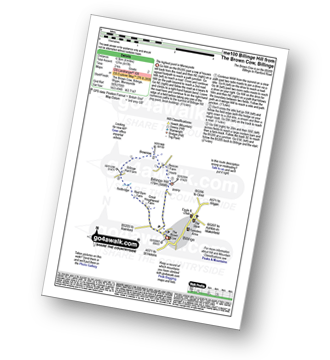
Route Summary:
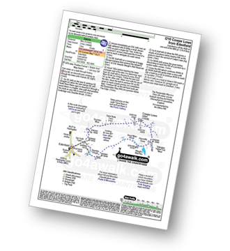
Billinge - Billinge Hill - Beacon Farm - Brownlow - Billinge Hall Farm - Red Barn Farm - Great Houghwood Farm - Billinge
|
Vital Statistics:
| Length: | 6.25 miles (10 km) |
| Ascent: | 128ft (39m) |
| Time: | 2½ hrs |
| Grade: |  |
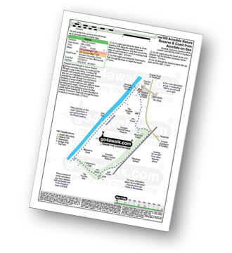
Route Summary:
Ainsdale-on-Sea - Ainsdale Discovery Centre - Ainsdale Nature Reserve - Ainsdale Hills - West End Lodge - Woodvale Airfield - The Formby Hills - Massam's Slack - Irish Sea - Ainsdale Sands - Ainsdale-on-Sea
|
Vital Statistics:
| Length: | 6.25 miles (10 km) |
| Ascent: | 879ft (268m) |
| Time: | 3.25hrs |
| Grade: |  |

Route Summary:
Lower Rivington Reservoir - Rivington - Upper Rivington Reservoir - Pilkington Wood - Street Wood - Yarrow Reservoir - Bradley Wood - Anglezarke Reservoir - High Bullough Reservoir - John Meadow Wood - Heapey Waterman's Cottage - Grey Heights Wood - Heapey Fold Lane - Kays Farm - Waring Fram - Lane Ends (Adlington) - Upper Rivington Reservoir - Lower Rivington Reservoir
|
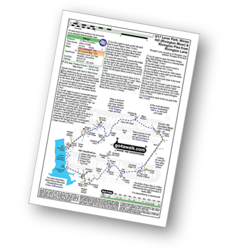
Vital Statistics:
| Length: | 4.5 miles (7 km) |
| Ascent: | 893ft (272m) |
| Time: | 2½ hrs |
| Grade: |  |

Route Summary:
Great House Information Centre - Rivington Hall - Rivington Cottage - Rivington Upper Barn - Pigeon Tower (Rivington Moor) - Rivington Pike - Brown Hill (Rivington Moor) - Higher Knoll - Rivington Lane Car Park - Lever Park - The Castle (Lower Rivington Reservoir) - Lower Rivington Reservoir - Great House Information Centre
|
Vital Statistics:
| Length: | 8.25 miles (13 km) |
| Ascent: | 1,230ft (375m) |
| Time: | 4 hrs |
| Grade: |  |
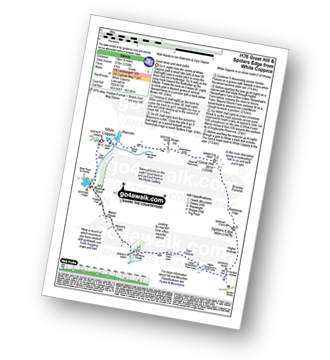
Route Summary:
White Coppice - Wheelton Moor - Withnell Moor - Great Hill - Redmonds Edge - Spitlers Edge - Horden Pasture - Lead Mines Clough - Anglezarke Reservoir - White Coppice
|
Vital Statistics:
| Length: | 7.75 miles (12.5 km) |
| Ascent: | 1,536ft (468m) |
| Time: | 4½ hrs |
| Grade: | |
Route Summary:
Rivington Lane Car Park - Lever Park - The Castle (Lower Rivington Reservoir) - Lower Rivington Reservoir - Great House Information Centre - Rivington Hall - Rivington Cottage - Rivington Upper Barn - Pigeon Tower (Rivington Moor) - Catter Nab - Noon Hill Slack - Moor Bottom - Winter Hill (Rivington Moor) - Crooked Edge Hill - Two Lads (Rivington Moor) - Pike Cottage - Brown Hill (Rivington Moor) - Rivington Pike - Higher Knoll - Rivington Lane Car Park
|
Vital Statistics:
| Length: | 5.5 miles (8.5 km) |
| Ascent: | 1,113ft (339m) |
| Time: | 3.25hrs |
| Grade: | |
Route Summary:
Rivington Upper Barn - Pigeon Tower (Rivington Moor) - Catter Nab - Noon Hill Slack - Moor Bottom - Winter Hill (Rivington Moor) - Crooked Edge Hill - Two Lads (Rivington Moor) - Pike Cottage - Brown Hill (Rivington Moor) - Rivington Pike - Pigeon Tower (Rivington Moor) - Rivington Upper Barn
|
Vital Statistics:
| Length: | 6.25 miles (10 km) |
| Ascent: | 400ft (122m) |
| Time: | 2.75hrs |
| Grade: | |

Route Summary:
Higher Walton - The Bridgewater Canal - Hillfoot Farm - The Mersey Valley Way - Bellfield Farm - Dennow Cottage - Dennow Farm - Hatton - Blue Coat Farm - Row's Wood - Moore - The Bridgewater Canal - Walton Hall - Higher Walton
|
Vital Statistics:
| Length: | 4.5 miles (7 km) |
| Ascent: | 190ft (58m) |
| Time: | 1.75hrs |
| Grade: | |
Route Summary:
Thelwall - Manchester Ship Canal - Thelwall Viaduct - Statham - The Bridgewater Canal - The Cheshire Ring Canal Walk - Thelwall
|
Vital Statistics:
| Length: | 3.75 miles (6 km) |
| Ascent: | 204ft (62m) |
| Time: | 2 hrs |
| Grade: | |

Route Summary:
The Trans Pennine Trail (Lymm) - Lymm - The Bridgewater Canal - The Cheshire Ring Canal Walk - Lymm Village - The Dingle - Lymm Dam - The Bongs - Crosfield Bridge - Lymm Dam - The Dingle - Lymm Cross - The Bridgewater Canal - The Cheshire Ring Canal Walk - Slitten Gorge - The Trans Pennine Trail - Lymm.
|
Vital Statistics:
| Length: | 11 miles (17.5 km) |
| Ascent: | 269ft (82m) |
| Time: | 4½ hrs |
| Grade: | |

Route Summary:
The Trans Pennine Trail (Lymm) - Lymm - Carr Green - Oldfield Brow - Altrincham - The Bridgewater Canal - The Cheshire Ring Canal Walk - Dunham Town - Dunham Massey - Little Bollington - The Bridgewater Canal - The Cheshire Ring Canal Walk - Agden Bridge - Oughtrington - Lymm Village - Slitten Gorge - The Trans Pennine Trail - Lymm.
|
Vital Statistics:
| Length: | 5.25 miles (8.5 km) |
| Ascent: | 246ft (75m) |
| Time: | 2.25hrs |
| Grade: | |

Route Summary:
The Trans Pennine Trail (Lymm) - Lymm - The Bridgewater Canal - The Cheshire Ring Canal Walk - Lymm Village - The Dingle - Lymm Dam - The Bongs - Crosfield Bridge - Oughtrington - The Bridgewater Canal - The Cheshire Ring Canal Walk - Rushgreen - Slitten Gorge - The Trans Pennine Trail - Lymm.
|
Vital Statistics:
| Length: | 4 miles (6.5 km) |
| Ascent: | 590ft (180m) |
| Time: | 2.25hrs |
| Grade: | |
Route Summary:
Holcombe Moor Car Park - Branch Rd - Top O'th' Moor Farm - Peel Tower - Taylor's Farm - Redisher Wood - Holcombe Brook - Holcombe Moor Car Park
|
Vital Statistics:
| Length: | 5.25 miles (8.5 km) |
| Ascent: | 686ft (210m) |
| Time: | 2.75hrs |
| Grade: | |
Route Summary:
Holcombe Moor Car Park - Holcombe - Higher Tops - Chatterton Close Farm - Buckden Wood - The Rossendale Way - Beetle Hill - Bull Hill (Holcombe Moor) - Pilgrim's Cross - Harcles Hill - Peel Tower - Top o'th'Moor Farm - Branch Road - Holcombe Moor Car Park
|
Vital Statistics:
| Length: | 6.75 miles (11 km) |
| Ascent: | 1,050ft (320m) |
| Time: | 3.75hrs |
| Grade: | |
Route Summary:
Holcombe Moor Car Park - Holcombe - Higher Tops - Chatterton Close Farm - Buckden Wood - The Rossendale Way - Beetle Hill - Bull Hill (Holcombe Moor) - Pilgrim's Cross - Harcles Hill - Peel Tower - Taylor's Farm - Redisher Wood - Holcombe Brook - Holcombe Car Park.
Not familiar with the area around L40?
See these 30 nearest walks to UK Postcode L40 on a google map
|
Vital Statistics:
| Length: | 6 miles (9.5 km) |
| Ascent: | 859ft (262m) |
| Time: | 3 hrs |
| Grade: | |
Route Summary:
Jeffrey Hill - Thornley Hall - Gibbon Bridge - River Loud - River Hodder - Weedacre Farm - Longridge Fell (Spire Hill) - Jeffrey Hill
|
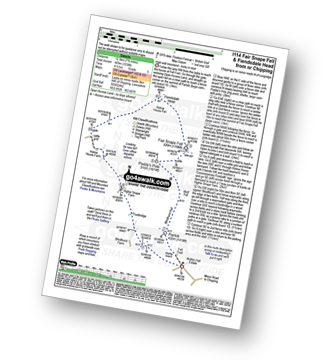
Vital Statistics:
| Length: | 6 miles (9.5 km) |
| Ascent: | 1,279ft (390m) |
| Time: | 3½ hrs |
| Grade: | |

Route Summary:
Fell Foot (nr Chipping) - Parlick - Blindhurst Fell - Wolf Fell - Paddy's Pole (Fair Snape Fell) - Fair Snape Fell - Saddle Fell - Ward's End - Saddle End Farm - Wolfen Hall - Fell Foot (nr Chipping)
|
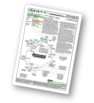
Vital Statistics:
| Length: | 7.75 miles (12.5 km) |
| Ascent: | 1,538ft (469m) |
| Time: | 4½ hrs |
| Grade: | |
Route Summary:
Fell Foot (nr Chipping) - Parlick - Blindhurst Fell - Wolf Fell - Paddy's Pole (Fair Snape Fell) - Fair Snape Fell - Holme House Fell - Fiendsdale Head - Holme House Farm - Higher Snape Farm - Fell Foot (nr Chipping)
|
Vital Statistics:
| Length: | 10 miles (16 km) |
| Ascent: | 1,597ft (487m) |
| Time: | 5.25hrs |
| Grade: |  |
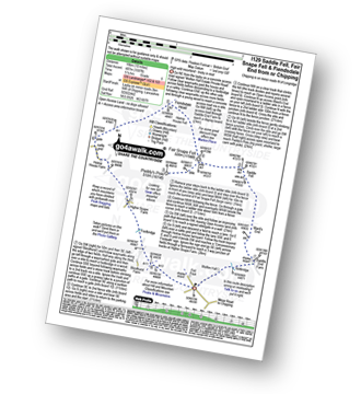
Route Summary:
Fell Foot (nr Chipping) - Wolfen Hall - Saddle End Farm - Ward's End - Saddle Fell - Paddy's Pole (Fair Snape Fell) - Fair Snape Fell - Holme House Fell - Fiendsdale Head - Holme House Farm - Higher Snape Farm - Fell Foot (nr Chipping)
|
Vital Statistics:
| Length: | 6.25 miles (10 km) |
| Ascent: | 1,254ft (382m) |
| Time: | 3½ hrs |
| Grade: | |

Route Summary:
Frodsham - Beacon Hill (Frodsham) - Frodsham Golf Course - Dunsdale Wood - Tong Dean - Helsby Hill Fort - Helsby Hill - The Longster Trail - Harmers Wood - The Sandstone Trail - Snidley Moor and Woodhouse Hill - Snidley Moor Wood - Beacon Hill (Frodsham) - Frodsham
|
Vital Statistics:
| Length: | 5 miles (8 km) |
| Ascent: | 1,044ft (318m) |
| Time: | 3 hrs |
| Grade: | |
Route Summary:
Edenfield - Gin Croft Lane - Dearden Moor - Sand Beds Farm - Cowpe Lowe - The Rossendale Way - Foe Edge - Horncliffe Close - Waugh's Well Reservoir - Scout Moor Brook - Dearden Clough - Edenfield
|
Vital Statistics:
| Length: | 7.25 miles (11.5 km) |
| Ascent: | 1,355ft (413m) |
| Time: | 4 hrs |
| Grade: | |

Route Summary:
Edenfield - Gin Croft Lane - Dearden Moor - Sand Beds Farm - Cowpe Lowe - The Rossendale Way - Foe Edge - Cowpe Moss - Cragg Quarry - Hail Storm Hill - Tottington Higher End Moor - Whittle Hill - New Gate Brook - Fecit Delf Endm Scout Moss - Turn - Dearden Clough - Edenfield
|
Vital Statistics:
| Length: | 6 miles (9.5 km) |
| Ascent: | 236ft (72m) |
| Time: | 2½ hrs |
| Grade: | |

Route Summary:
Dunham Town - The Bridgewater Canal - The Cheshire Ring Canal Walk - Agden Bridge - Agden Brook Farm - Arthill Farm - Reddy Lane Cottage - Little Bollington - Dunham Massey Park - Dunham Park - Dunham Town
|
Vital Statistics:
| Length: | 3.75 miles (6 km) |
| Ascent: | 197ft (60m) |
| Time: | 1.75hrs |
| Grade: | |
Route Summary:
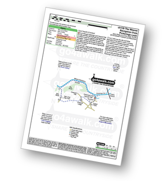
Pickerings Lock - The Weaver Navigation - The Belt - Hall O' The' Hey Farm - Crewood Lodge - The Hurst - Oakwell Farm - Pickerings Lock
|
Vital Statistics:
| Length: | 5.5 miles (8.5 km) |
| Ascent: | 158ft (48m) |
| Time: | 2.25hrs |
| Grade: | |

Route Summary:
Arley - Arley Hall - Arley Brook - Hollies Farm - Antrobus - Budworth Heath - Great Budworth - Stockley Farm - Arley
|
Vital Statistics:
| Length: | 4 miles (6.5 km) |
| Ascent: | 233ft (71m) |
| Time: | 1.75hrs |
| Grade: | |
Route Summary:
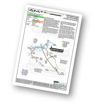
Acton Bridge - Manor Farm - Dutton Locks - River Weaver - Pickerings Cut - Dutton Viaduct - Pickerings Lock - Oakhill Farm - Cliff Brook - Lower Green Farm - Acton Bridge
|
Vital Statistics:
| Length: | 7.25 miles (11.5 km) |
| Ascent: | 384ft (117m) |
| Time: | 3 hrs |
| Grade: | |

Route Summary:
Acton Bridge - Manor Farm - Dutton Locks - River Weaver - Pickerings Cut - Dutton Viaduct - Pickerings Lock - The Weaver Navigation - The Belt - Hall O' The' Hey Farm - Crewood Lodge - Oakhill Farm - Cliff Brook - Lower Green Farm - Acton Bridge
|
Vital Statistics:
| Length: | 7 miles (11 km) |
| Ascent: | 1,198ft (365m) |
| Time: | 3.75hrs |
| Grade: | |
Route Summary:
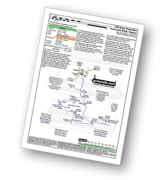
Lane Ends - Hapton - The Burnley Way - Hameldon Hill - May Road Well - Great Hameldon - Hameldon Common - Hameldon Scouts - Lane Ends - Hapton.
|
Vital Statistics:
| Length: | 5 miles (8 km) |
| Ascent: | 338ft (103m) |
| Time: | 2.25hrs |
| Grade: | |

Route Summary:
Little Leigh - Friar's Rough - Trent and Mersey Canal - Bardleymeadow Wood - Daleford House - Saltersford Tunnel - Barnton - Stone Heyes Farm - Desley Heath Farm - Claterwick Farm - Little Leigh
|
Vital Statistics:
| Length: | 6.75 miles (11 km) |
| Ascent: | 370ft (110m) |
| Time: | 3 hrs |
| Grade: | |
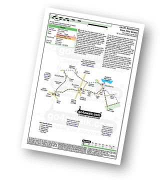
Route Summary:
Hoo Green - Hulseheath - Gorse Barn - Millington Brook - Agden Brook - Denfield Hall Farm - Rostherne Brook - Rostherne - Rostherene Mere Nature Reserve - Marsh Farm - Rostherne - Cicely Mill - Bucklow Hill - Hulseheath - Hoo Green
Not familiar with the area around L40?
See these 30 nearest walks to UK Postcode L40 on a google map


