UK Postcode BN10 - The 30 nearest easy-to-follow, circular walk route maps to you
The thirty nearest easy-to-follow, circular walk route maps to you in UK Postcode BN10 in Walk Grade Order
The UK cities, towns and villages in East Sussex, England that have BN10 in their UK Postcode include:
• Peacehaven • Telscombe Cliffs •
Not familiar with the area around BN10?
See these 30 nearest walks to UK Postcode BN10 on a google map
   |
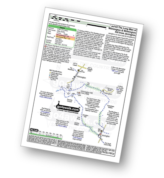
Vital Statistics:
| Length: | 6 miles (9.5 km) |
| Ascent: | 729ft (222m) |
| Time: | 3 hrs |
| Grade: |  |

Route Summary:
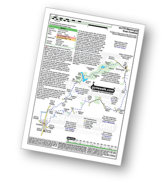
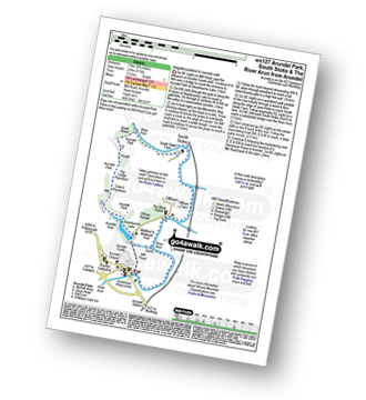
Westdean - The South Down Way - Cliff End - Cuckmere Haven - Exceat Bridge - Cuckmere River - Charlston Manor - Westdean
|
Vital Statistics:
| Length: | 9.75 miles (15.5 km) |
| Ascent: | 1,122ft (342m) |
| Time: | 4.75hrs |
| Grade: |  |
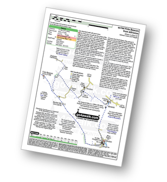
Route Summary:
Alfriston - The South Downs Way - Bostal Hill - Firle Beacon - Tilton Farm - Charleston Farmhouse - Upper Barn - Bopeep Farm - Alciston - Berwick - The Vanguard Way - Alfriston
|
Vital Statistics:
| Length: | 2.75 miles (4.5 km) |
| Ascent: | 154ft (47m) |
| Time: | 1.25hrs |
| Grade: |  |
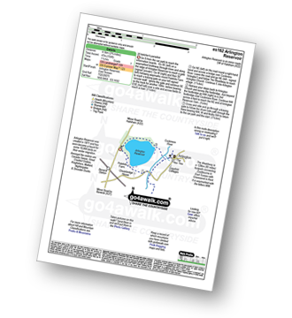
Route Summary:
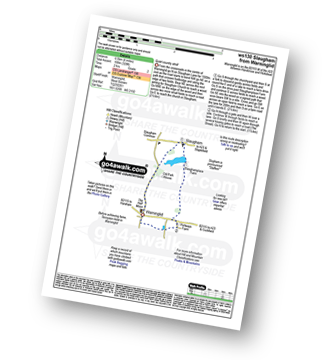
Arlington Reservoir - Polehills Farm - The Wealdway - Arlington - Cuckmere River - Arlington Reservoir
|
Vital Statistics:
| Length: | 8.5 miles (13.5 km) |
| Ascent: | 1,388ft (423m) |
| Time: | 4½ hrs |
| Grade: | |
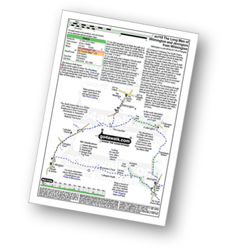
Route Summary:
Wilmington - The Wealdway - The Long Man of Wilmington - The South Downs Way - Lullington Church - Litlington - Litlington Heath - Jevington - The Wealdway - Cranedown Bottom - Folkington - The Holt - Wilmington
|
Vital Statistics:
| Length: | 7.25 miles (11.5 km) |
| Ascent: | 1,109ft (338m) |
| Time: | 3.75hrs |
| Grade: |  |

Route Summary:
Wilmington - The Wealdway - The Long Man of Wilmington - The South Downs Way - Lullington Church - Litlington - Litlington Heath - Jevington Holt - Wilmington Hill - The Wealdway - The Holt - Wilmington
|
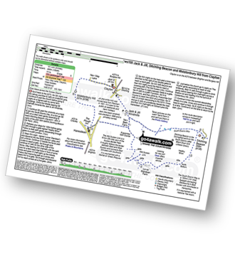
Vital Statistics:
| Length: | 5.5 miles (9 km) |
| Ascent: | 804ft (245m) |
| Time: | 2.75hrs |
| Grade: | |
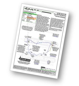
Route Summary:
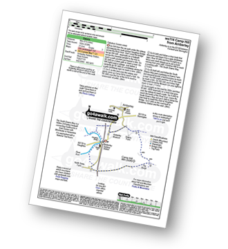
Ditchling Beacon Car Park - Ditchling Beacon - Heathy Brpw - Borth Bottom - Lower Standean Farm - New Barn Farm - Clayton Windmills - Jill Windmill - Jack Windmill - The South Downs Way - Ditchling Beacon.
|
Vital Statistics:
| Length: | 7.75 miles (12.5 km) |
| Ascent: | 1,466ft (447m) |
| Time: | 4½ hrs |
| Grade: | |

Route Summary:
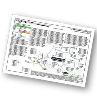
East Dean - Ringwood Bottom - East Dean Hill - Warren Hill - Crapham Bottom - East Hale Bottom - Wigden's Bottom - Hod Combe - Belle Tout Lighthouse - Birling Gap - Went Hill - East Dean
|
Vital Statistics:
| Length: | 14.5 miles (23 km) |
| Ascent: | 3,177ft (968m) |
| Time: | 8½ hrs |
| Grade: |  |

Route Summary:
East Dean - Ringwood Bottom - East Dean Hill - The South Downs Way - Beachy Head - Belle Tout - Birling Gap - The Seven Sisters - Went Hill - Michel Dean - Bailey's Hill - Flathill Bottom - Flat Hill - Flagstaff Bottom - Flagstaff Brow - Gap Bottom - Brass Point - Rough Bottom - Rough Brow - Limekiln Bottom - Short Brow - Short Bottom - Haven Brow - Cliff End - Exceat - Westdean - Begger's Croft - Friston Forest - Middle Brow - Friston Hill - Friston Place - East Dean
|
Vital Statistics:
| Length: | 8.25 miles (13 km) |
| Ascent: | 1,594ft (486m) |
| Time: | 4½ hrs |
| Grade: | |

Route Summary:
East Dean - The South Downs Way - The Seven Sisters - Went Hill - Michel Dean - Bailey's Hill - Flathill Bottom - Flat Hill - Flagstaff Bottom - Flagstaff Brow - Gap Bottom - Brass Point - Rough Bottom - Rough Brow - Limekiln Bottom - Short Brow - Short Bottom - Haven Brow - Cliff End - Exceat - Westdean - Begger's Croft - Friston Forest - Middle Brow - Friston Hill - Friston Place - East Dean
|
Vital Statistics:
| Length: | 8.5 miles (13.5 km) |
| Ascent: | 2,045ft (623m) |
| Time: | 5.25hrs |
| Grade: |  |

Route Summary:
East Dean - Ringwood Bottom - East Dean Hill - The South Downs Way - Beachy Head - Belle Tout - Birling Gap - Went Hill - East Dean
|
Vital Statistics:
| Length: | 6.75 miles (10.5 km) |
| Ascent: | 952ft (290m) |
| Time: | 3.25hrs |
| Grade: | |
Route Summary:
Jevington - The Wealdway - Cranedown Bottom - Folkington - The Holt - The Long Man of Wilmington - The South Downs Way - Wilmington Hill - Tenantry Ground - Jevington Holt - Jevington
|
Vital Statistics:
| Length: | 9 miles (14.5 km) |
| Ascent: | 1,594ft (486m) |
| Time: | 5 hrs |
| Grade: | |
Route Summary:
Clayton - Clayton Windmills - Jill Windmill - Jack Windmill - The South Downs Way - Ditchling Beacon - Heathy Brow - North Bottom - Lower Standean Farm - New Barn Farm - The South Downs Way - Haresdean - Wolstonbury Hill - Clayton
|
Vital Statistics:
| Length: | 4.5 miles (7 km) |
| Ascent: | 754ft (230m) |
| Time: | 2½ hrs |
| Grade: | |

Route Summary:
Clayton - Clayton Windmills - Jill Windmill - Jack Windmill - The South Downs Way - New Barn Farm - Haresdean - Wolstonbury Hill - Clayton
|
Vital Statistics:
| Length: | 6.25 miles (10 km) |
| Ascent: | 1,152ft (351m) |
| Time: | 3½ hrs |
| Grade: | |

Route Summary:
East Dean Hill Car Park - East Dean Hill - The South Downs Way - Beachy Head - Belle Tout - Hod Combe - Birling Gap - Wigden's Bottom - East Hale Bottom - Crapham Bottom - East Dean Hill.
|
Vital Statistics:
| Length: | 7 miles (11 km) |
| Ascent: | 505ft (154m) |
| Time: | 3 hrs |
| Grade: | |
Route Summary:
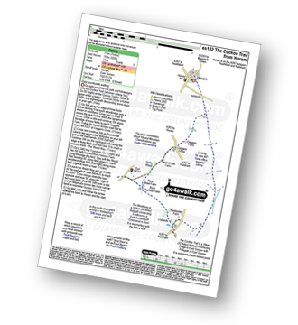
Horam - The Cuckoo Trail - Coggers Farm - Cogger's Cross - Pickly Wood - Gun Hill - The Wealdway - Lealands - The Cuckoo Trail - Horam
Not familiar with the area around BN10?
See these 30 nearest walks to UK Postcode BN10 on a google map
|
Vital Statistics:
| Length: | 3.75 miles (6 km) |
| Ascent: | 689ft (210m) |
| Time: | 2.25hrs |
| Grade: | |
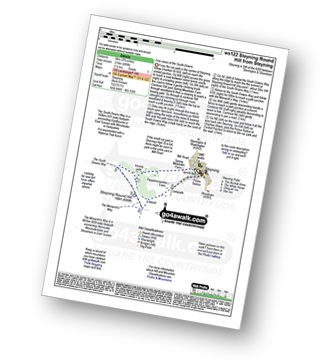
Route Summary:
Steyning - Spring Meadows Farm - The South Downs Way - Steyning Round Hill - The Monarch's Way - Pepperscoombe Farm - Steyning
|
Vital Statistics:
| Length: | 9 miles (14.5 km) |
| Ascent: | 951ft (290m) |
| Time: | 4 hrs |
| Grade: | |
Route Summary:
Cowfold - Brook House - Picts Farm - Graffields - Hookland Farm - Bushy Platts - Minepits Woods - New Pond - Furnace Pond - Leonardslee Estate - Freechase Hill - William's Wood - Stonedelf - Warninglid - Rout Farm - Colwood Park House - Colwwod Manor - Earwig Lane - Bull's Wood - Long House Farm - aWallhurst Manor - Cowfold
|
Vital Statistics:
| Length: | 4 miles (6.5 km) |
| Ascent: | 328ft (100m) |
| Time: | 2 hrs |
| Grade: |  |
Route Summary:
Warninglid - Old Park House - Slaugham - Slaughamplace Farm - Colwood - Portways Farm - Warninglid
|
Vital Statistics:
| Length: | 6 miles (9.5 km) |
| Ascent: | 262ft (80m) |
| Time: | 2½ hrs |
| Grade: | |

Route Summary:
Ashington - Mitchbourne Farm - Greenhurst Farm - Abingworth - Thakeham - Warminghurst - Ashington
|
Vital Statistics:
| Length: | 7.75 miles (12.5 km) |
| Ascent: | 932ft (284m) |
| Time: | 3.75hrs |
| Grade: | |
Route Summary:
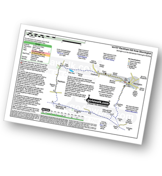
Storrington - Greyfriars Farm - Chantry Hill - Kithurst Hill - The South Downs Way - Springhead Hill - Rackham Hill - Rackham - Parham House - Cootham - Storrington
|
Vital Statistics:
| Length: | 9 miles (14.5 km) |
| Ascent: | 948ft (289m) |
| Time: | 4.25hrs |
| Grade: | |
Route Summary:
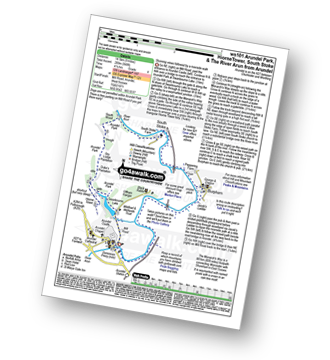
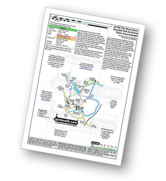
Arundel - Arundel Castle - Swanbourne Lake - Arundel Park - The Monarch''s Way - Hiorne Tower - Duke's Plantation - Dry Lodge Plantation - South Wood - The River Arun - South Stoke - Burpham - Arundel
|
Vital Statistics:
| Length: | 6.75 miles (11 km) |
| Ascent: | 715ft (218m) |
| Time: | 3.25hrs |
| Grade: | |
Route Summary:
Arundel - Arundel Castle - Swanbourne Lake - Arundel Park - The Monarch''s Way - Hiorne Tower - Duke's Plantation - Dry Lodge Plantation - South Wood - The River Arun - South Stoke - The River Arun - Offham - Wildfowl Reserve - Arundel
|
Vital Statistics:
| Length: | 4.75 miles (7.5 km) |
| Ascent: | 475ft (145m) |
| Time: | 2½ hrs |
| Grade: | |
Route Summary:
Arundel - Arundel Castle - The River Arun - Wildfowl Reserve - Offham - Offham Hanger - Swanbourne Lake - Arundel Park - The Monarch''s Way - Hiorne Tower - Arundel Cathedral - Arundel Chapel - Arundel Castle - Arundel
|
Vital Statistics:
| Length: | 6.25 miles (10 km) |
| Ascent: | 660ft (201m) |
| Time: | 3 hrs |
| Grade: | |

Route Summary:
Amberley Museum - Amberley Railway Station - Houghton Bridge - The River Arun - North Stoke - Camp Hill - The South Downs Way - Amberley Village - Amberley Castle - The River Arun - Amberley.
|
Vital Statistics:
| Length: | 5.5 miles (9 km) |
| Ascent: | 630ft (192m) |
| Time: | 2½ hrs |
| Grade: | |
Route Summary:
Amberley Museum - Amberley Railway Station - Houghton Bridge - The River Arun - North Stoke - Camp Hill - The South Downs Way - High Titten - Foxleigh Down - The River Arun - Amberley.
|
Vital Statistics:
| Length: | 3.5 miles (5.5 km) |
| Ascent: | 16ft (5m) |
| Time: | 1½ hrs |
| Grade: | |
Route Summary:
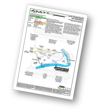
Climping Beach - Atherington - Kent's Farm - Ryebank Rife - River Arun - Littlehampton - Littlehampton Harbour - The Mill - Climping - Climping Beach
|
Vital Statistics:
| Length: | 6.25 miles (10 km) |
| Ascent: | 141ft (43m) |
| Time: | 2½ hrs |
| Grade: | |
Route Summary:
Lingfield - Park Farm - Puttenden Manor - Haxted Watermill - River Eden - Eden Brook - Cernes Farm - Starborough Castle - St Piers School - Lingfield Railway Station - Lingfield
|
Vital Statistics:
| Length: | 6.25 miles (10 km) |
| Ascent: | 40ft (12m) |
| Time: | 2.25hrs |
| Grade: | |
Route Summary:
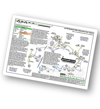
Yapton - Yapton Gardens - Bilsham - Ryebank Rife - Weststone Bridge - Westfield - Lidsey Rife - The Portsmouth and Arundel Navigation Canal - Tilebarn Farm - Barnham - Yapton
|
Vital Statistics:
| Length: | 4.5 miles (7 km) |
| Ascent: | 236ft (72m) |
| Time: | 2 hrs |
| Grade: | |
Route Summary:
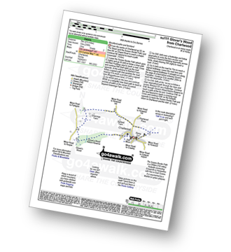
Charlwood - The Sussex Border Path - Barfield Farm - Greenings Farm - Glover's Wood Nature Reserve - Charlwood
|
Vital Statistics:
| Length: | 4.5 miles (7 km) |
| Ascent: | 453ft (138m) |
| Time: | 2 hrs |
| Grade: | |

Not familiar with the area around BN10?
See these 30 nearest walks to UK Postcode BN10 on a google map


