   |
Vital Statistics:
| Length: | 6¾mls (10.5km) |
| Ascent: | 952ft (290m) |
| Time: | 3¼hrs |
| Grade: |  |
Route outline for walk es143:
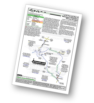
Jevington - The Wealdway - Cranedown Bottom - Folkington - The Holt - The Long Man of Wilmington - The South Downs Way - Wilmington Hill - Tenantry Ground - Jevington Holt - Jevington
Points of Interest/Notes on this walk:
The Long Man of Wilmington is 72m (235ft) long & is designed to look in proportion when viewed from below. Originally thought to originate in the Iron Age or Neolithic period, an investigation in 2003 has shown the figure to originate in the 16th or 17th century. At first, the figure appears to have been carved from the underlying chalk but closer inspection reveals it to be formed from white-painted breeze blocks & lime mortar.
Peaks, Summits and Tops reached on this walk:
 0 English Mountains |
 0 Wainwrights |
 0 English Nuttalls |
 0 English Deweys |
 0 Wainwright Outlying Fells |
 1 Marilyn |
 0 Bridgets |
Peak Bagging Statistics for this walk:
The highest point of this walk is Wilmington Hill at 214m (702ft). Wilmington Hill is classified as an English Marilyn (167th highest in England, 1508th highest in the UK). The summit of Wilmington Hill is marked by an Ordnance Survey Trig Point.
National Trails & Long Paths included on this walk:
Part of this walk follows a section of The South Downs Way, a 162km (101 miles) linear footpath connecting Eastbourne (Holywell) in East Sussex, England with Winchester in Hampshire, England. The South Downs Way is waymarked by a National Trail acorn. For more walks that include a section of this trail see The South Downs Way.
You can find this walk and other nearby walks on these unique free-to-access Interactive Walk Planning Maps:
1:25,000 scale OS Explorer Map (orange/yellow covers):
1:50,000 scale OS Landranger Map (pink/magenta covers):
Some Photos and Pictures from Walk es143 Folkington and The Long Man of Wilmington from Jevington
In no particular order . . .


Send us your photographs and pictures from your walks and hikes
We would love to see your photographs and pictures from walk es143 Folkington and The Long Man of Wilmington from Jevington. Send them in to us as email attachments (configured for any computer) along with your name and where the picture was taken to:
and we shall do our best to publish them.
(Guide Resolution = 300dpi. At least = 660 pixels (wide) x 440 pixels (high).)

You can also submit photos from walk es143 Folkington and The Long Man of Wilmington from Jevington via our Facebook Page.
NB. Please indicate where each photo was taken.


