10 walks in The Chiltern Hills (Chilterns)
Interactive Map of Walks in The Chiltern Hills (Chilterns)
![]() How to Load this interactive map: Due to usage restrictions, you must be Registered and Logged-On to go4awalk.com to view and use the interactive Google Map below. You do not need to purchase any credits, but you must be Registered and Logged-On.
How to Load this interactive map: Due to usage restrictions, you must be Registered and Logged-On to go4awalk.com to view and use the interactive Google Map below. You do not need to purchase any credits, but you must be Registered and Logged-On.

You can use these checkboxes to show only the grades of walk you are interested in:-
Ten easy-to-follow, circular, walk route maps in The Chiltern Hills (Chilterns) in Walk Number Order (First to Last)
See this list of walks, routes & maps in:
Grade Order | Length Order | Time Order | Walk Number or Start Location Order
NB. To reverse (toggle) this order, click Number Order again
Scroll down the list of walks below & click on each walk title (in blue) to locate it on the map above.
   |
Vital Statistics:
| Length: | 6.5 miles (10.5 km) |
| Ascent: | 230 ft (70 m) |
| Time: | 2½ hrs |
| Grade: |  |
Route Summary:
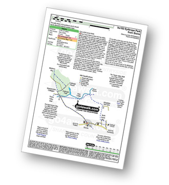
Stone - Hartwell Church - Upper Hartwell - Whaddon Hill Farm - The North Bucks Way - River Thame - Thame Valley Walk - The Midshires Way - Weir Lodge - Bridge Lodge - Eythrope Park - Beachendon Cottages - Eythrope House - Aylesbury Ring - Stone
|
Vital Statistics:
| Length: | 4.5 miles (7 km) |
| Ascent: | 693 ft (211 m) |
| Time: | 2½ hrs |
| Grade: |  |

Route Summary:
Great Kimble - The North Bucks Way - Askett - Monks Risborough - Whiteleaf - The Icknield Way - The Ridgeway - Whiteleaf Cross - Cadsden - Grangelands And Pulpit Hill Nature Reserve - Chequer's Knap - The North Bucks Way - Great Kimble
|
Vital Statistics:
| Length: | 5.5 miles (9 km) |
| Ascent: | 853 ft (260 m) |
| Time: | 3 hrs |
| Grade: | |

Route Summary:
Butler's Cross - Monument Hill (Coombe Hill) - The Ridgeway - Linton's Wood - Goodmerhill Wood - Chisley Wood - The Icknield Way - Chequers - Pond Wood - Pulpit Wood - The North Bucks Way - The Midshires Way - Chequers Knap - Whorley Wood - Ellesborough Warren - Boxtree Wood - Beacon Hill (Ellesborough) - Ellesborough - The Aylesbury Ring - Springs Farm - Butler's Cross
|
Vital Statistics:
| Length: | 6 miles (9.5 km) |
| Ascent: | 528 ft (161 m) |
| Time: | 2.75 hrs |
| Grade: | |
Route Summary:
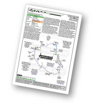
Bledlow - The Midshires Way - The Warren - The Ridgeway - Thickthorn Wood - Lodge Hill - Longwood Farm - The Old Rectory - Saunderton - Horsenden - Bledlow
|
Vital Statistics:
| Length: | 3.75 miles (6 km) |
| Ascent: | 538 ft (164 m) |
| Time: | 2 hrs |
| Grade: | |
Route Summary:
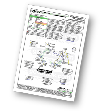
Little Hampden Common - Little Hampden - The South Bucks Way - Cobblershill Farm - The Chiltern Way - Cockshoots Wood - Mayortorne Manor - Russell Farm - Dunsmore - Scrub Wood - Hampdenleaf Wood - The Icknield Way - Little Hampden Common
|
Vital Statistics:
| Length: | 6.5 miles (10 km) |
| Ascent: | 722 ft (220 m) |
| Time: | 3 hrs |
| Grade: | |

Route Summary:
Dagnall - Chlitern Farm - Former Radio Station - Gallows Hill - Ivinghoe Beacon - The Ridgeway - Ivinghoe Hills - Steps Hill - Down Farm - Clipperdown Cottage - Clipper Down - Ward's Hurst Farm - Hog Hall - Hog Hall Lane - Dagnall
|
Vital Statistics:
| Length: | 8.25 miles (13 km) |
| Ascent: | 919 ft (280 m) |
| Time: | 4 hrs |
| Grade: |  |
Route Summary:
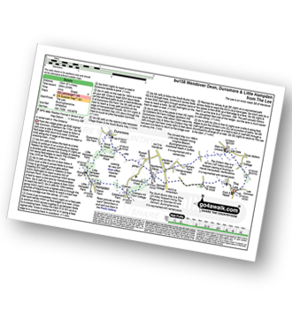
The Lee - Kiln Cottage - Lee Gate - The Chiltern Way - Durham Farm - Wendoverdean Farm - Wendover Dean - Mayortorne Manor - Russell Farm - Dunsmore - Scrub Wood - Hampdenleaf Wood - The Icknield Way - Little Hampden Common - Little Hampden - The South Bucks Way - Cobblershill Farm - The Chiltern Way - Cockshoots Wood - Mayortorne Manor - Spinney Cottage - The Lee
|
Vital Statistics:
| Length: | 5.5 miles (9 km) |
| Ascent: | 722 ft (220 m) |
| Time: | 2.75 hrs |
| Grade: | |
Route Summary:
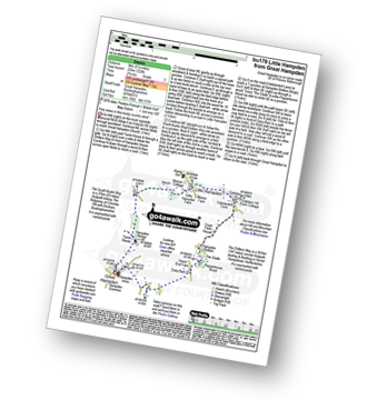
Great Hampden - The Chiltern Way - Hampden House - Little Hampden - The South Bucks Way - Cobbleshill Farm - Hampden Bottom - Pepperboxes Wood - Honor End Farm - Great Hampden
|
Vital Statistics:
| Length: | 4.5 miles (7 km) |
| Ascent: | 345 ft (105 m) |
| Time: | 2 hrs |
| Grade: | |
Route Summary:
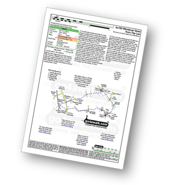
The Lee - Kiln Cottage - Lee Gate - The Chiltern Way - Durham Farm - Wendoverdean Farm - Wendover Dean - Mayortorne Manor - Spinney Cottage - The Lee
|
Vital Statistics:
| Length: | 5 miles (8 km) |
| Ascent: | 230 ft (70 m) |
| Time: | 2 hrs |
| Grade: | |
Route Summary:
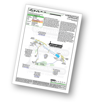
Little Missenden - The South Bucks Way - Lower Park - Shardeloes Lake - Amersham Cricket Ground - Lower Park House - Wheatley Wood - Mop End - Mop End Farm - Taby's Lane - Breaches Wood - Little Missenden
See this list of walks, routes & maps in:
Grade Order | Length Order | Time Order | Walk Number or Start Location Order
NB. To reverse (toggle) this order, click Number Order again


