11 easy-to-follow walk, route maps of all grades on OS Landranger Map 138 Kidderminster & Wyre Forest
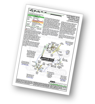
Eleven easy-to-follow walk, route maps of all grades on OS Landranger Map 138 Kidderminster & Wyre Forest in Walk Grade OrderTap/mouse over a coloured circle (1-3 easy walks, 4-6 moderate walks, 7-9 hard walks) and click to select.
You can use these checkboxes to show only the grades of walk you are interested in:-
Eleven easy-to-follow walk, route maps of all grades on OS Landranger Map 138 Kidderminster & Wyre Forest in Walk Grade Order
Scroll down the list of walks below & click on each walk title (in blue) to locate it on the map above.
See this list of walks, routes & maps in:
Grade Order | Length Order | Time Order | Walk Number or Start Location Order
NB. To reverse (toggle) this order, click Grade Order again
   |
Vital Statistics:
| Length: | 6.5 miles (10.5 km) |
| Ascent: | 1,152ft (351m) |
| Time: | 3½ hrs |
| Grade: |  |

Route Summary:
Cleobury North - Stanbroughs Wood - Brown Clee Hill (Abdon Burf) - The Shropshire Way - Sandy Nap - Monkeys Fold - Green Lea - Brown Clee Hill (Clee Burf) - Chapelwod Farm - Wallermoore Wood - Harewood - Cleobury North
|
Vital Statistics:
| Length: | 10.25 miles (16.5 km) |
| Ascent: | 2,435ft (742m) |
| Time: | 6.25hrs |
| Grade: |  |

Route Summary:
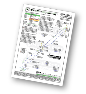
Church Stretton - The Jack Mytton Way - Snatchfield Farm - Clemcroft - Ragleth Hill - Ragdon Manor - Gaerstones Farm - Caer Caradoc Hill - Little Caradoc - Church Stretton
|
Vital Statistics:
| Length: | 5.25 miles (8.5 km) |
| Ascent: | 532ft (162m) |
| Time: | 2½ hrs |
| Grade: |  |
Route Summary:
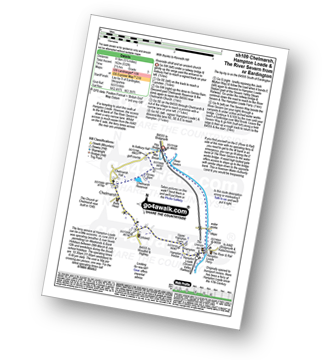
Eardington - Dinney Barn - The Jack Mytton Way - Chelmarsh Reservoir - Chelmarsh - Hampton - The Jack Mytton Way - The Severn Valley Railway - Hampton Loade - The Hampton Loade Ferry - The River Severn - The Severn Way - Eardington
|
Vital Statistics:
| Length: | 7 miles (11 km) |
| Ascent: | 1,214ft (370m) |
| Time: | 3.75hrs |
| Grade: | |

Route Summary:
Church Stretton - Three Fingers Rock - Caer Caradoc Hill - Little Caradoc - Comley - Church Stretton
|
Vital Statistics:
| Length: | 4 miles (6.5 km) |
| Ascent: | 1,011ft (308m) |
| Time: | 2½ hrs |
| Grade: | |

Route Summary:
Dhustone - The Shropshire Way - Nine Spring Farm - Titterstone Incline - Titterstone Clee Hill - Hullabaloo House - Titterstone - Benson' Brook - Woodlands - Greenacres - Dhustone
|
Vital Statistics:
| Length: | 9.5 miles (15.5 km) |
| Ascent: | 1,132ft (345m) |
| Time: | 4.75hrs |
| Grade: |  |
Route Summary:
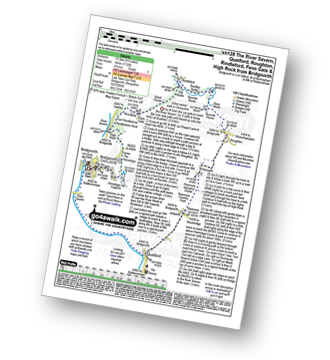
Bridgnorth - The River Severn - Quatford - Stanmore Country Park - Hoccum - Roughton - Burcote House - River Worfe - Soudley Rocks - Rindleford - Batch House - Fenn Gate - Woodside - High Rock - Caves - The Hermitage - Hermitage Hill Coppice - Bridgnorth
|
Vital Statistics:
| Length: | 5.25 miles (8.5 km) |
| Ascent: | 945ft (288m) |
| Time: | 3 hrs |
| Grade: | |
Route Summary:
Church Stretton - The Jack Mytton Way - Snatchfield Farm - Clemcroft - Ragleth Hill - Ragdon Manor - Church Stretton
|
Vital Statistics:
| Length: | 8.5 miles (13.5 km) |
| Ascent: | 1,791ft (546m) |
| Time: | 5 hrs |
| Grade: | |
Route Summary:
Leebotwood - The Lawley - Comley - Caer Caradoc Hill - Three Fingers Rock - Comley - Leebotwood
|
Vital Statistics:
| Length: | 4 miles (6.5 km) |
| Ascent: | 712ft (217m) |
| Time: | 2.25hrs |
| Grade: | |

|
Vital Statistics:
| Length: | 5.75 miles (9 km) |
| Ascent: | 1,027ft (313m) |
| Time: | 3.25hrs |
| Grade: | |
Route Summary:
Church Stretton - The Jack Mytton Way - Snatchfield Farm - Clemcroft - Ragleth Hill - Little Stretton - Church Stretton
|
Vital Statistics:
| Length: | 10 miles (16 km) |
| Ascent: | 722ft (220m) |
| Time: | 4.25hrs |
| Grade: | |

Route Summary:
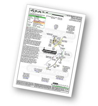
Bridgnorth - Lower Town - River Severn - The Severn Way - Apley Forge - Nordley - Astley Abbots - Cross Lane Head - High Town - Bridgnorth - Lower Town - Bridgnorth
See this list of walks, routes & maps in:
Grade Order | Length Order | Time Order | Walk Number or Start Location Order
NB. To reverse (toggle) this order, click Grade Order again


