Walk sh147 The Lawley from nr Leebotwood

Gentle uphill walk to superb views


Route outline for walk sh147:

Leebotwood  -  The Lawley  -  Comley  -  Leebotwood


Peaks, Summits and Tops reached on this walk:

hewitt
0
English
Mountains
Wainwright
0
Wainwrights
 English Nuttalls
0
English
Nuttalls
Dewey
0
English
Deweys
Wainwright Outlying Fell
0
Wainwright
Outlying Fells
marilyn
0
Marilyns
Bridget
1
Bridget

Peak Bagging Statistics for this walk:

The highest point of this walk is The Lawley at 377m (1237ft). The Lawley is known as an English Bridget. The summit of The Lawley is marked by a tall weather vane.


You can find more walks near this one on these unique free-to-access Interactive Walk Planning Maps: (click/TAP to select)


1:25,000 scale OS Explorer Map (the ones with orange/yellow covers):

217 The Long Mynd & Wenlock Edge


1:50,000 scale OS Landranger Maps (the ones with pink/magenta covers):

137 Ludlow & Church Stretton, Wenlock Edge


138 Kidderminster & Wyre Forest


Some Photos and Pictures from Walk sh147 The Lawley from nr Leebotwood

In no particular order . . .

Walk sh147 The Lawley from nr Leebotwood - On the way up The Lawley

On the way up The Lawley

Photo: Howard Moore (1)

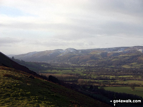
Walk sh147 The Lawley from nr Leebotwood - The Long Mynd and Church Stretton from the northern approach to The Lawley

The Long Mynd and Church Stretton from the northern approach to The Lawley

Photo: Howard Moore (2)


Send us your photographs and pictures from your walks and hikes

We would love to see your photographs and pictures from walk sh147 The Lawley from nr Leebotwood. Send them in to us as email attachments (configured for any computer) along with your name and where the picture was taken to:

and we shall do our best to publish them.

(Guide Resolution = 300dpi. At least = 660 pixels (wide) x 440 pixels (high).)

Send us your walking and hiking photographs and pictures from walk sh147 The Lawley from nr Leebotwood via Facebook

You can also submit photos from walk sh147 The Lawley from nr Leebotwood via our Facebook Page.

NB. Please indicate where each photo was taken.


Do not miss our pick of the Best Walks in the UK


Follow go4awalk.com on Twitter Follow go4awalk.com on Facebook


Find new Friends to go walking with

Walk all 214 Wainwrights in just 59 Walks. Download GPS Waypoints - Great Walks you must not miss!

Walk The Yorkshire Three Peaks Challenge Walk - All the Latest Route Information, GPS Waypoints and Split Times to keep you on Schedule

Walk The British Three Peaks Challenge Walk - All the Latest Route Information and GPS Waypoints

See our pick of The Best Walks in The Lake District - Great Walks you must not miss!

Walk our pick of the Best Lake District Ridge Walks - Great Walks you must not miss!

Walk our pick of the Best Lake District Walks to do in the rain - Great Walks you must not miss!

Walk our pick of The Best Walks in Snowdonia - Great Walks you must not miss!

Walk our pick of The Best Ridge Walks in Wales - Walks you must not miss!

Walk our pick of The Best Walks in The Brecon Beacons - Great Walks you must not miss!

Walk our pick of The Best Walks in The Yorkshire Dales - Walks you must not miss!

Walk our pick of The Best Walks in The Peak District - Walks you must not miss!

Walk our pick of The Best Walks in The Forest of Bowland - Walks you must not miss!

Walk our pick of The Best Walks in Shropshire - Walks you must not miss!

Walk our pick of The Best Walks in Cheshire - Walks you must not miss!

Walk our pick of The Best Walks in Lancashire - Walks you must not miss!

Not sure where to walk next? Try Peak Bagging - Great Walks you must not miss!

Not sure where to walk next? Walk part of a National Trail - Great Walks you must not miss!

Walks with Downloadable and Uploadable GPS Waypoint Data

Walking Kit and Gear Tested by Walkers

Full Site Search
Do not miss our pick of the Best Walks in Britain